My setup:
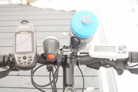
Magellan Explorist 500 on the left. And just in case you're wondering, that's the Bionx (eBike) controller on the right.
I love the Magellan on the bike for several reasons:
1 - Their bike mount is pretty sturdy. If you do crash, the GPS just pops out and bounces on the ground a bit. Not a problem for the Explorist series, they're pretty sturdy. Also the bike mount is easy to install and it positions the screen directly within your view.
2 - The 500 has a color backlit screen. So it's both useable in daytime and nighttime. Backlighting is adjustable.
3 - Built-in geocaching, if you're into that sort of thing. Mountain bikes are great for geocaching.
4 - Track logs are pretty usefull if you need to backtrack and for analysis afterwards. I especially like the fact that it even considers altitude.
5 - Routes are very useful. Every so often I discover some new trail deep in the woods so I simply convert that track to a route so the next time I want to go there I activate that route and follow the directions.
6 - ETA (Estimated time of arrival) is pretty usefull when following a route. That way if you get a cell phone call, you can tell your firends/wife approx. which time you'll be home.
7 - Points of interest are really useful. If you want to visit some location on a trail, just download the POI and map a route to it. Or if you suddenly find something really sweet, just log a POI and then you can download it into the computer later on. Every so often I see something special and take a picture. Then I'll plug in a POI into the GPS just to know where I took said picture. Usefull with google earth.
8 - Speed, distance, odometer (you can reset the odo), avg speed, time, ETA, distance to next waypoint etc. Many options you can select on the active display so it replaces a cycle computer for the most part. I only miss the cadence meter, the rest I can use the GPS for.
And since I have the Bionx, the speedo is built-in so I just glance to the right to see the speed. The GPS is about +/- 0.5 km/h off. Strangely enough, the explorist 500 is dead on with my car GPS (Factory navigation in my Acura). Maybe the Bionx is off? Not sure.
Don't forget that you can use a handheld Explorist for many other things; walking, taking mesurements, car, plane... yes... PLANE, boating (marking fishing spots) etc.
It's a very practical device and very well suited for bikes. Especially those who go deep in the woods.
Edit: Forgot to mention this: I purchased Magellan Mapsend Topo for Canada. So it's not just streets. There's plenty of POIs included as well as geopgraphical data like rivers, streams, trails, parks and the like. Best of all since it's a topo map you get altitude data. So you can actually see the outline of the mountain you climbing. if you suddenly see many altitude lines really close together in front of your position? Watch out... that means a near vertical drop.