


Highway Cycling
 05-16-09, 06:44 PM
#1
Senior Member
Thread Starter
Join Date: Jun 2008
Posts: 271
Mentioned: 0 Post(s)
Tagged: 0 Thread(s)
Quoted: 0 Post(s)
Likes: 0
Liked 0 Times
in
0 Posts
Highway Cycling
Has anyone addressed the issues that would be concerned with successfully planning and executing bike routes that involve highways? Any good ideas or suggestions on how to determine which ones would be smart or not smart to try and ride?
 05-16-09, 08:22 PM
#2
Guest
Posts: n/a
Mentioned: Post(s)
Tagged: Thread(s)
Quoted: Post(s)
Is there a particular area of the country you're concerned about? Lot of differences depending on the highways of a particular state, and interstate highways have some federal regualtions that apply, too.
05-16-09, 08:33 PM
#3


Fresh Garbage

well if you're willing to risk a ticket, you probably be safest taking the freeway when it is rush hour and totally conjested/ pumper to bumper.
here is video of a demonstration ride that has happened a few times in Los Angeles.
https://www.youtube.com/watch?v=VNZSe8Q8-Iw
here is video of a demonstration ride that has happened a few times in Los Angeles.
https://www.youtube.com/watch?v=VNZSe8Q8-Iw
05-16-09, 08:54 PM
#4
In Real Life

Join Date: Jan 2003
Location: Down under down under
Posts: 52,152
Bikes: Lots
Mentioned: 141 Post(s)
Tagged: 0 Thread(s)
Quoted: 3203 Post(s)
Liked 596 Times
in
329 Posts
 I don't ride in towns unless I have to in order to get through them and back onto the highway again.
I am one of the route planners for the Alberta Randonneur brevets (a 200K, a 300K, a 400K, and a 600K), and those are 98% highway. Check with your local Randonneuring club to see where their routes have been planned and have a chat with their route planners. Check with your local Cycletouring club to see where their routes have been planned and have a chat with their route planners. You might also check with our own Touring forum and Long Distance forum ... most of the riders in those forums ride on the highway.
And get a map ... go ride.

Many of these photos have been taken from highway rides:
https://www.flickr.com/photos/14302884@N04/sets/
This photo is from one of my favorite highway routes ... my father and I just rode it again today, and I'll be posting those photos shortly.

__________________
Rowan
My fave photo threads on BF
Century A Month Facebook Group
Machka's Website
Photo Gallery
Rowan
My fave photo threads on BF
Century A Month Facebook Group
Machka's Website
Photo Gallery
Last edited by Machka; 05-16-09 at 08:58 PM.
05-16-09, 09:15 PM
#5
Joyously Phred
Join Date: May 2008
Location: 600 miles from the nearest flat road
Posts: 126
Bikes: Raleigh Passage 3.0, Giant Halfway 2007 folding, Trek Lime Easy-Step
Mentioned: 0 Post(s)
Tagged: 0 Thread(s)
Quoted: 1 Post(s)
Likes: 0
Liked 0 Times
in
0 Posts
Not every highway is a major federal interstate - I think the OP is referring more to the type of highway with major traffic, but room on the shoulder for people to ride. Highways that aren't illegal to anything but motorized traffic.
Some highways in my area have bike lanes/mup's that run directly beside the highway, with just a concrete barrier to seperate from the regular lanes. Particularly nice for crossing the two main rivers that cut off the metro from the 'burbs. Saves a lot of side-street manoeuvering. These aren't usually marked on regular street maps, but we have a few popular bike route maps that show where these parallel lanes are.
There is one highway that is frequented by cyclists but doesn't have a barrier, just a large shoulder. The bike maps warn about traffic, and people who know the area know that it's a fave spot for cyclists because it connects to several other major highways that have bike lanes and goes direct to/from downtown and the major 'burbs - so they know in advance to be visible and keep right.
My commute last year involved both types - I had to take the non-marked highway for about 2 miles during morning rush. But the shoulder was wide enough that it was like having a lane to myself, only had to keep an eye out for the cross-streets. And the next leg of the commute had me on the bike lane of the even busier highway, but there was an official bike lane with a barrier.
I guess that would be what I'd look for if I was looking at a new area and planning a commute from scratch = is the shoulder wide enough to accomodate me if necessary, and if not, are there streets that parallel for the trickier parts if the traffic got to be too much?
05-16-09, 09:35 PM
#6
Fresh Garbage
Many of these photos have been taken from highway rides:
https://www.flickr.com/photos/14302884@N04/sets/
This photo is from one of my favorite highway routes ... my father and I just rode it again today, and I'll be posting those photos shortly.
 I want to ride out in a place like that. I can actually, but I would need a group because I'd feel uncomfortable out there alone.
https://www.flickr.com/photos/14302884@N04/sets/
This photo is from one of my favorite highway routes ... my father and I just rode it again today, and I'll be posting those photos shortly.
I want to ride out in a place like that. I can actually, but I would need a group because I'd feel uncomfortable out there alone.
05-16-09, 10:09 PM
#7

Crankenstein

Join Date: May 2006
Location: Spokane
Posts: 4,037
Bikes: Novara Randonee (TankerBelle)
Mentioned: 0 Post(s)
Tagged: 0 Thread(s)
Quoted: 1 Post(s)
Likes: 0
Liked 3 Times
in
3 Posts
Many of these photos have been taken from highway rides:
https://www.flickr.com/photos/14302884@N04/sets/
This photo is from one of my favorite highway routes ... my father and I just rode it again today, and I'll be posting those photos shortly.
I want to ride out in a place like that. I can actually, but I would need a group because I'd feel uncomfortable out there alone.
https://www.flickr.com/photos/14302884@N04/sets/
This photo is from one of my favorite highway routes ... my father and I just rode it again today, and I'll be posting those photos shortly.
I want to ride out in a place like that. I can actually, but I would need a group because I'd feel uncomfortable out there alone.I once had to stop for a herd of elk. I stayed WAY back!
__________________
"There is no greater wonder than the way the face and character of a woman fit so perfectly in a man's mind, and stay there, and he could never tell you why. It just seems it was the thing he most wanted." Robert Louis Stevenson


"There is no greater wonder than the way the face and character of a woman fit so perfectly in a man's mind, and stay there, and he could never tell you why. It just seems it was the thing he most wanted." Robert Louis Stevenson
05-16-09, 10:16 PM
#8
Senior Member
Thread Starter
Join Date: Jun 2008
Posts: 271
Mentioned: 0 Post(s)
Tagged: 0 Thread(s)
Quoted: 0 Post(s)
Likes: 0
Liked 0 Times
in
0 Posts
Yes, I'm definitely a bit envious of the fun places most here seem to ride from looking at some of these posts on here. Definitely different than the places I'm used to - maybe that's part of it.
05-16-09, 10:18 PM
#9
Senior Member

Join Date: May 2008
Location: Zang's Spur, CO
Posts: 9,080
Mentioned: 11 Post(s)
Tagged: 0 Thread(s)
Quoted: 3370 Post(s)
Liked 5,491 Times
in
2,844 Posts
Check with the state. e.g. For CO:
Here is the main page: https://www.dot.state.co.us/BikePed/maps.htm
First look at the Legend: https://www.dot.state.co.us/BikePed/Maps/Legend.pdf
Then look at the State Map: https://www.dot.state.co.us/BikePed/M...Bike%20Map.pdf
The legend explains that only the roads marked with alternating black & yellow are prohibited.
Permitted roads are colored to indicate how wide the shoulder is.
Note that only portions of I-70 are prohibited, and there are notes indicating the alternative route.
05-16-09, 10:23 PM
#10
In Real Life
Join Date: Jan 2003
Location: Down under down under
Posts: 52,152
Bikes: Lots
Mentioned: 141 Post(s)
Tagged: 0 Thread(s)
Quoted: 3203 Post(s)
Liked 596 Times
in
329 Posts
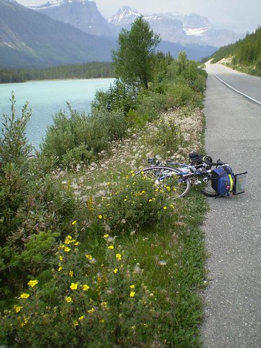
This was one of the rides I did out there alone:
https://www.flickr.com/photos/1430288...7606660549120/
Here's one of the shots in that set ... a lovely bit of highway on the Icefield Parkway:
__________________
Rowan
My fave photo threads on BF
Century A Month Facebook Group
Machka's Website
Photo Gallery
Rowan
My fave photo threads on BF
Century A Month Facebook Group
Machka's Website
Photo Gallery
05-16-09, 10:27 PM
#11
cowboy, steel horse, etc

Join Date: Sep 2008
Location: The hot spot.
Posts: 44,784
Bikes: everywhere
Mentioned: 71 Post(s)
Tagged: 1 Thread(s)
Quoted: 12736 Post(s)
Liked 7,647 Times
in
4,055 Posts
Sometimes google maps helps ascertain which highways have shoulders. Then there's drive-'em before you ride 'em.
05-16-09, 10:31 PM
#12
In Real Life
Join Date: Jan 2003
Location: Down under down under
Posts: 52,152
Bikes: Lots
Mentioned: 141 Post(s)
Tagged: 0 Thread(s)
Quoted: 3203 Post(s)
Liked 596 Times
in
329 Posts
Not really finding anything close to me, just a longer distance route that happens to cross my area, and they use all the "usual suspects" I'm already aware of, so really no clue on anything new. The only other thing I can think of is to try to find those "planned rides" (MS 150, Tour De Cure, etc) and see what routes they are choosing to use. Though, one or two of my concerns is exhibited in these roads, still (i.e. fast cars, no shoulders).
__________________
Rowan
My fave photo threads on BF
Century A Month Facebook Group
Machka's Website
Photo Gallery
Rowan
My fave photo threads on BF
Century A Month Facebook Group
Machka's Website
Photo Gallery
05-16-09, 11:29 PM
#13
Senior Member
Thread Starter
Join Date: Jun 2008
Posts: 271
Mentioned: 0 Post(s)
Tagged: 0 Thread(s)
Quoted: 0 Post(s)
Likes: 0
Liked 0 Times
in
0 Posts
I'm in MO, most highways don't have shoulders.
05-17-09, 12:15 AM
#14
In Real Life
Join Date: Jan 2003
Location: Down under down under
Posts: 52,152
Bikes: Lots
Mentioned: 141 Post(s)
Tagged: 0 Thread(s)
Quoted: 3203 Post(s)
Liked 596 Times
in
329 Posts
Okay, that's what I do for most of my unknown rides, to know what I'm getting myself into. The problem, I guess is how do I "make sure the route is OK" from driving? What are the criteria that people use? Kind of hard to count traffic as you travel along, watch specific times (i.e. may be safe at 8am but not 12pm?), and notice when the shoulder appears and disappears, and to boot pay attention enough to be safe while driving. More gut instinct or something specific?
I'm in MO, most highways don't have shoulders.
I'm in MO, most highways don't have shoulders.
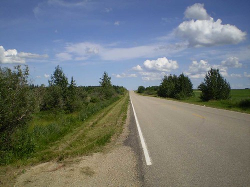
The main criteria to look for, as you're driving along, is ... would I want to cycle this road, or not? I've driven some roads and thought, "There's no way!" ... but I've driven other roads, and thought, "I can't wait to get out here on a bicycle!"
Of course the next thing is to go out and ride it. After I've mapped and driven the routes I want to use for brevets, I try to ride all or most of them, as well as other roads in the area.
This is another highway in my area. It has no shoulders and from just going out and riding it at different times of the day, I've discovered that it is fairly busy between about 4 and 5pm when people are going home from work. But much of the rest of the time it looks like the photo below.
__________________
Rowan
My fave photo threads on BF
Century A Month Facebook Group
Machka's Website
Photo Gallery
Rowan
My fave photo threads on BF
Century A Month Facebook Group
Machka's Website
Photo Gallery
05-17-09, 08:50 AM
#15
Guest
Posts: n/a
Mentioned: Post(s)
Tagged: Thread(s)
Quoted: Post(s)
Check with the Missouri state police to see what they impose on bicyclists on state highways (intra-state highways). It typically varies from state-to-state, and can be influenced by how rural the area is where you're riding; as a rule of thumb, the more rural, the less enforcement. Federally funded interstate highways allow bicyclists to ride on the shoulder if there's no other reasonable roadway heding in their direction of travel. Can get a little dicey if you're in a populous state (like here in California). While riding from Los Angeles to Las Vegas a few years ago I had a tough time with the Calif Highway PAtrol on I-15, but the Nevada H.P was really accomodating one I crossed the state line.
As mentioned, also consider how wide the shoulder is on your route, and balance that with the amount of traffic and type of traffic (a road full of big trucks vs a road with cars is quite different).
Riding alone is really quite nice. Since you don't have the distriction of other people, you tend to notice more of whats around you. An old saying is "if you're not comfortable with yourself, how can you be comfortable in the presence of others?" Guess it all depends on how you analyze risk factors.
05-17-09, 09:07 AM
#16
Senior Member
Join Date: May 2008
Location: Zang's Spur, CO
Posts: 9,080
Mentioned: 11 Post(s)
Tagged: 0 Thread(s)
Quoted: 3370 Post(s)
Liked 5,491 Times
in
2,844 Posts
I don't drive routes as a matter of principle; It just doesn't seem right to burn time, money, and fossil-fuel as preparation for an energy-efficient, healthy excercise.
05-17-09, 09:18 AM
#17
totally louche

Join Date: Oct 2004
Location: A land that time forgot
Posts: 18,023
Bikes: the ever shifting stable loaded with comfortable road bikes and city and winter bikes
Mentioned: 0 Post(s)
Tagged: 0 Thread(s)
Quoted: 0 Post(s)
Likes: 0
Liked 10 Times
in
9 Posts
pretty pictures of canadian rural highways aside- got any of the 17 outside Thunder Bay, Machka?
Many states offer bicycling maps that show traffic volumes and suitability of shoulders/bike routes.
the Adventure Cycling Association also offers great detailed maps for cyclists that offer up good highway routes.
contact the local and state bike organizations about local county bike maps, etc. Just looking at local area bike websites often leads to local bike-specific mapping and road suggestions..
https://mobikefed.org/momaps.php
doh!
Last edited by Bekologist; 05-17-09 at 09:23 AM.
05-17-09, 09:31 AM
#18
Senior Member
Join Date: Oct 2008
Posts: 414
Mentioned: 0 Post(s)
Tagged: 0 Thread(s)
Quoted: 0 Post(s)
Likes: 0
Liked 0 Times
in
0 Posts
I live in Wisconsin and have always been hesitant to ride our state highways. That is now changing.
State highways vs county roads mean higher visibility in many cases. Long curves, long up and down grades assist an automobile driver to see me for longer periods of time.
I use a safety vest. I have both head and tail lights that tend not to fade in the sunlight. I use a mirror and watch what is behind me and anticipate what is approaching me from the front and if two vehicles will come together close to me, I will move over.
I tend to avoid high traffic areas and watch the sun to make certain drivers are not blinded by it and not see me.
As always, defensive riding is most important.
05-17-09, 12:51 PM
#19
Senior Member
Thread Starter
Join Date: Jun 2008
Posts: 271
Mentioned: 0 Post(s)
Tagged: 0 Thread(s)
Quoted: 0 Post(s)
Likes: 0
Liked 0 Times
in
0 Posts
contact the local and state bike organizations about local county bike maps, etc. Just looking at local area bike websites often leads to local bike-specific mapping and road suggestions..
https://mobikefed.org/momaps.php
doh!
https://mobikefed.org/momaps.php
doh!
It's hard to know without being a local, I suppose. Or burning up a lot of petrol driving the route multiple times. But always seems an element of chance involved.
05-17-09, 01:08 PM
#20
In Real Life
Join Date: Jan 2003
Location: Down under down under
Posts: 52,152
Bikes: Lots
Mentioned: 141 Post(s)
Tagged: 0 Thread(s)
Quoted: 3203 Post(s)
Liked 596 Times
in
329 Posts
It's even more interesting when you're on a tour and trying to get from Point A to Point B. Sometimes you end up on less-than-ideal roads. You deal with it, and try to find something better as soon as possible.
This happened during my tour in Australia in 2004. For the most part the roads there were fine, but someone (the person who ran a particular campground) suggested that we take the Old Bruce Highway, in Queensland, rather than the Bruce Highway. He told us it was more scenic, and that the Bruce Highway was a main dual carriage way highway and that we wouldn't want to ride it. We took his advice and got onto the Old Bruce. I don't know if they were doing construction way down at one end of it or if it was always like that, but we were run off the road several times by gravel trucks. There was no shoulder, and these things would come up behind us and not pull out the least little bit even though they had room to do so. I don't mind traffic in general, but the first one of these that went by and came within inches of my handlebars scared me. We'd see them in our mirrors (and hear them), and would ride off the road into the ditch. We were on that road for a while, but first chance we got, we moved to the main Bruce Highway. It was busier, but there was a wide shoulder. So you don't always know what you'll end up with when you do long rides in areas outside of your own local area.
Here are the two Randonneuring clubs in your state:
https://www.geocities.com/stlbrevets/index.html
https://www.kcbrevets.blogspot.com/
They may have suggestions for you because chances are the riders in those clubs have ridden all over the state, and the route plannners may have done a lot of driving.
You might also check to see if there are any tours mentioned in CrazyGuy:
https://www.crazyguyonabike.com/
__________________
Rowan
My fave photo threads on BF
Century A Month Facebook Group
Machka's Website
Photo Gallery
Rowan
My fave photo threads on BF
Century A Month Facebook Group
Machka's Website
Photo Gallery


 05-17-09, 08:31 PM
#22
totally louche
Join Date: Oct 2004
Location: A land that time forgot
Posts: 18,023
Bikes: the ever shifting stable loaded with comfortable road bikes and city and winter bikes
Mentioned: 0 Post(s)
Tagged: 0 Thread(s)
Quoted: 0 Post(s)
Likes: 0
Liked 10 Times
in
9 Posts
The challenge always is whether you trust what the maps say compared to experience. Time of measurement always seems important compared to aggregate, which is what those maps are. For a couple of the roads on a ride which were marked "low-volume" on the map, I counted maybe a dozen vehicles that passed me in an 11 mile stretch on one (great!), but on the next, I had two dozen cars pass me from both directions before I hit the first hill (bad!). Maybe the second road might be passable another time.
It's hard to know without being a local, I suppose. Or burning up a lot of petrol driving the route multiple times. But always seems an element of chance involved.
It's hard to know without being a local, I suppose. Or burning up a lot of petrol driving the route multiple times. But always seems an element of chance involved.
So you read the maps, or look at pictures of the roads, and go ride the routes, or scope them beforehand, or ask for local knowledge on local bike websites and from clubs, etc..
what's the underlying issue? do you take reasonable safety precautions like wear high viz clothing, operate daytime visible LED array on flash, use a slo-mo safety triangle, rear view mirror, and know how to control a highway speed road on your bicycle?
then grab a map, plan a route, and go ride!
05-18-09, 06:57 AM
#23
genec

Join Date: Sep 2004
Location: West Coast
Posts: 27,079
Bikes: custom built, sannino, beachbike, giant trance x2
Mentioned: 86 Post(s)
Tagged: 0 Thread(s)
Quoted: 13658 Post(s)
Liked 4,532 Times
in
3,158 Posts
Except without cars for the most part. Catalina has very few cars and trucks at all... most vehicles in Avalon are golf carts, except for taxies and work vehicles (such as the sheriff cars). I did a ride from Two Harbors to Parsons' Landing about 2 years ago... and damn it was a blast, and the only traffic was a slow moving stake side truck that gave me all the room it could. (I think it was moving supplies to one of the camps just north of Two Harbors.
It was a blast to ride this wide empty well graded road. (I used a rental bike)
But I imagine such roads also exist all over Arizona too.
It was a blast to ride this wide empty well graded road. (I used a rental bike)
But I imagine such roads also exist all over Arizona too.
05-18-09, 11:24 AM
#24
In Real Life
Join Date: Jan 2003
Location: Down under down under
Posts: 52,152
Bikes: Lots
Mentioned: 141 Post(s)
Tagged: 0 Thread(s)
Quoted: 3203 Post(s)
Liked 596 Times
in
329 Posts
Is this for your own personal rides, or are you organizing routes for your club?
__________________
Rowan
My fave photo threads on BF
Century A Month Facebook Group
Machka's Website
Photo Gallery
Rowan
My fave photo threads on BF
Century A Month Facebook Group
Machka's Website
Photo Gallery
05-18-09, 12:27 PM
#25
Arizona Dessert

Join Date: Jun 2004
Location: AZ
Posts: 15,030
Bikes: Cannondale SuperSix, Lemond Poprad. Retired: Jamis Sputnik, Centurion LeMans Fixed, Diamond Back ascent ex
Mentioned: 76 Post(s)
Tagged: 0 Thread(s)
Quoted: 5345 Post(s)
Liked 2,169 Times
in
1,288 Posts
Take a look at this large pdf format map provided by Arizona Dept. of Trans. Note how each highway is coded for shoulder width and traffic volume. There are also symbols for grade and narrow shouldered bridges.
https://www.azbikeped.org/maps.htm
https://www.azbikeped.org/maps.htm