


Blame it on the rain.....
 10-14-09, 10:53 PM
#1
Guest
Posts: n/a
Mentioned: Post(s)
Tagged: Thread(s)
Quoted: Post(s)
Blame it on the rain.....
ARGH! Once again a bicycling weekend is getting rained on, or rained out. I should be in Harper's Ferry, WV, on Friday, and the area is getting up to two inches of rain through Saturday. The C & O Canal Towpath is going to be impossible to ride.
My plans were to see Harper's Ferry on Friday, spend the night at the hostel in Knoxville, and then ride up the towpath Saturday to Shepardstown, and across to Sharpsburg to tour Antietam Battlefield. I can't win.
My plans were to see Harper's Ferry on Friday, spend the night at the hostel in Knoxville, and then ride up the towpath Saturday to Shepardstown, and across to Sharpsburg to tour Antietam Battlefield. I can't win.
10-14-09, 11:04 PM
#2
Senior Member
Join Date: Oct 2008
Posts: 439
Mentioned: 0 Post(s)
Tagged: 0 Thread(s)
Quoted: 1 Post(s)
Likes: 0
Liked 0 Times
in
0 Posts
Sounds like your cycling year has been as fraught with problems as mine. I'm ending the year with less than half of my intended distance thanks to various difficulties. Now, we've already seen some snow, though I'm hoping for at least a couple more days warm enough and free of ice that I can squeeze in at least another 50 miles.
The good news is, Loke (my husky) still has covered the most ground ever this year. Last year, he did 562. This year, 683. I only cycled 177 miles without him as opposed to 650+ last year. So, at least some accomplishments this year.
The good news is, Loke (my husky) still has covered the most ground ever this year. Last year, he did 562. This year, 683. I only cycled 177 miles without him as opposed to 650+ last year. So, at least some accomplishments this year.
 10-18-09, 08:20 AM
#4
Junior Member

Join Date: Aug 2009
Location: North Carolina
Posts: 16
Mentioned: 0 Post(s)
Tagged: 0 Thread(s)
Quoted: 0 Post(s)
Likes: 0
Liked 0 Times
in
0 Posts
The C & O Canal Towpath is going to be impossible to ride
I have loved canal tow-path cycling ever since I cycled from Dublin to Mullingar and back along the Royal Canal in 1998. Also, where I am from in England (Leicester, you'll be amazed to learn) is on the Grand Union canal (a major waterway, in its day). Because tow paths tend to be fairly flat, some days I would start out with the intention of a medium distance training run, and end up miles away from home...
A famous (and quite picturesque) part of the Grand Union canal is located at Foxton, approx 15 miles south of Leicester (photo below.)

Apologies, I digress. Returning to the C&O Canal. The thought of "330 traffic free miles from Washington, DC all the way to Pittsburgh, PA" sounds wonderful...I think this is definitely going in my 'future cycle tour' file...However the same web-page I gleaned this information from (https://bikewashington.org/canal/) also notes: "The towpath is not paved (the surface is typically clay and crushed stone), so it is a bit rough," which, means, I guess, that my Schwinn Tourer will not be up to the task. Sounds like I would have to acquire another bike (an MTB?) for the trip. Oh dear, what a disappointment..(!)
 10-18-09, 04:58 PM
#5
Guest
Posts: n/a
Mentioned: Post(s)
Tagged: Thread(s)
Quoted: Post(s)
Ah, you set me thinking...I'm fairly new to the United States, and have to Google pretty much everything apart from the names of States and major cities to determine where / what these places are...The C & O Canal Towpath look superb...
I have loved canal tow-path cycling ever since I cycled from Dublin to Mullingar and back along the Royal Canal in 1998. Also, where I am from in England (Leicester, you'll be amazed to learn) is on the Grand Union canal (a major waterway, in its day). Because tow paths tend to be fairly flat, some days I would start out with the intention of a medium distance training run, and end up miles away from home...
A famous (and quite picturesque) part of the Grand Union canal is located at Foxton, approx 15 miles south of Leicester (photo below.)
Apologies, I digress. Returning to the C&O Canal. The thought of "330 traffic free miles from Washington, DC all the way to Pittsburgh, PA" sounds wonderful...I think this is definitely going in my 'future cycle tour' file...However the same web-page I gleaned this information from (https://bikewashington.org/canal/) also notes: "The towpath is not paved (the surface is typically clay and crushed stone), so it is a bit rough," which, means, I guess, that my Schwinn Tourer will not be up to the task. Sounds like I would have to acquire another bike (an MTB?) for the trip. Oh dear, what a disappointment..(!)
I'm in Harpers Ferry tonight. The towpath drains very well here, so I expect to get some good riding in tomorrow.
10-18-09, 05:33 PM
#6
Guest
Posts: n/a
Mentioned: Post(s)
Tagged: Thread(s)
Quoted: Post(s)
https://www.bikely.com/maps/bike-path...ietam-and-back
10-18-09, 07:07 PM
#7
Guest
Posts: n/a
Mentioned: Post(s)
Tagged: Thread(s)
Quoted: Post(s)
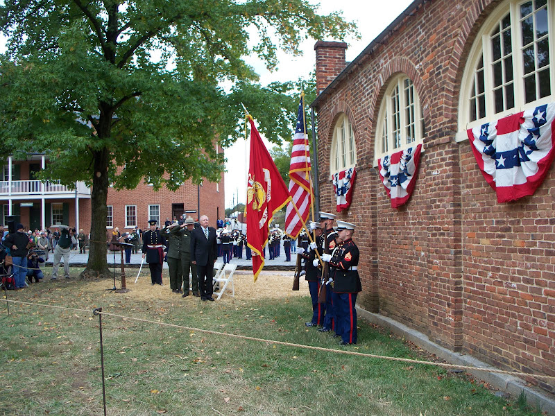
That said, I'm glad I came. As part of the 150th anniversary of John Brown's raid the NPS had presentations and events all weekend, including a wreath laying honoring a Marine who was killed in the 1859 raid. I took some nice shots of the color guard and Marine band in front of "John Brown's fort."
Lots of photos on the way. West Virginia is wonderful. I love this place, aside from the stress it causes my knees and legs.
10-19-09, 09:38 PM
#8
Vorsprung durch Technik
Join Date: Apr 2007
Location: Fairmont, WV
Posts: 310
Bikes: 2007 Specialized Crossroads, 1985 Raleigh Sportif
Mentioned: 0 Post(s)
Tagged: 0 Thread(s)
Quoted: 0 Post(s)
Likes: 0
Liked 0 Times
in
0 Posts
Neil, it was good chatting with you. We will have to plan a ride in the future.
10-19-09, 10:22 PM
#9
Guest
Posts: n/a
Mentioned: Post(s)
Tagged: Thread(s)
Quoted: Post(s)
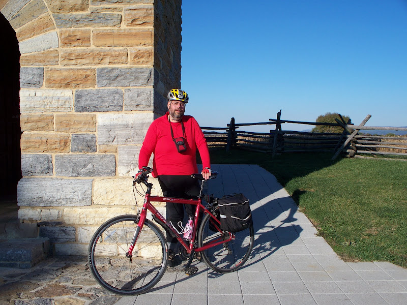
Tomorrow's route, although it will probably be trimmed a little, since I'm not spending tomorrow night at the hostel.
https://www.bikely.com/maps/bike-path...ietam-and-back
https://www.bikely.com/maps/bike-path...ietam-and-back
10-20-09, 08:18 AM
#10
Guest
Posts: n/a
Mentioned: Post(s)
Tagged: Thread(s)
Quoted: Post(s)
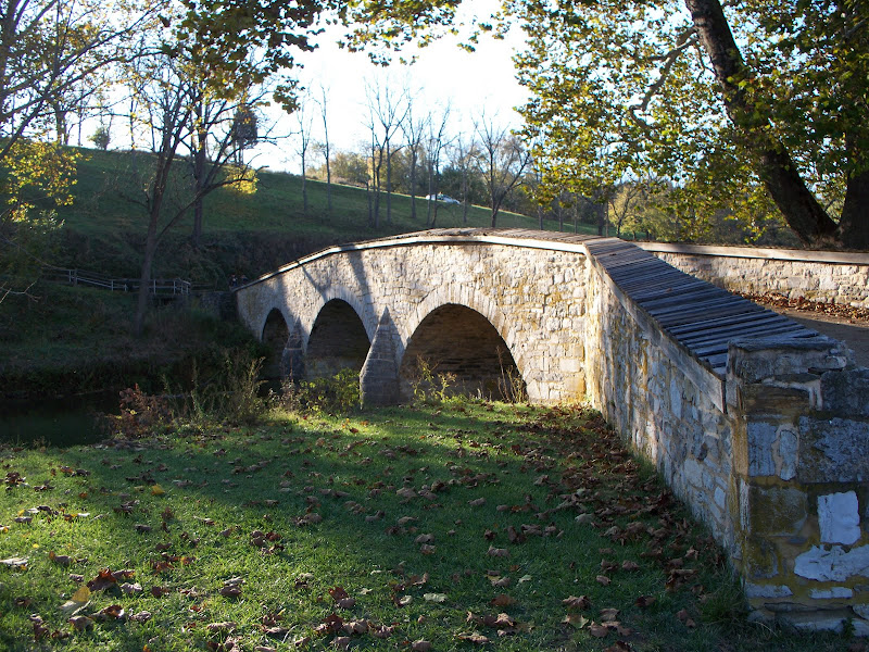
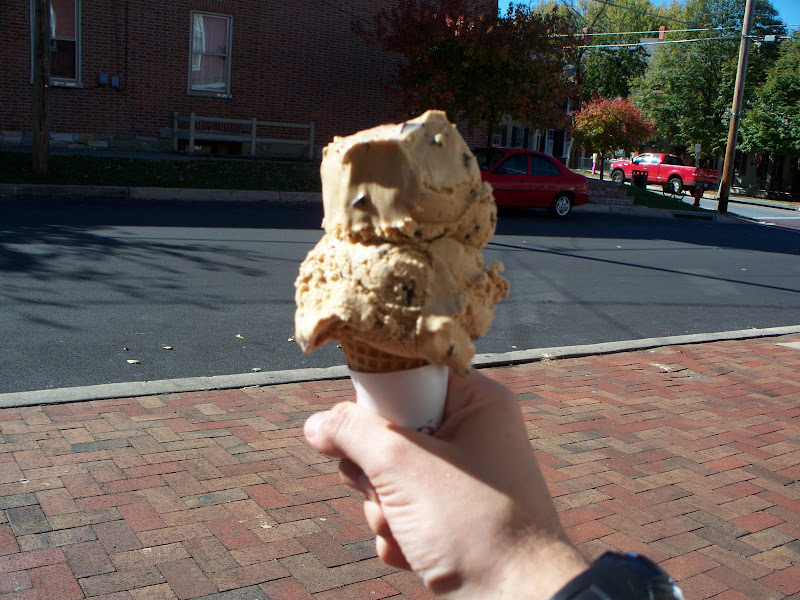
I wound up with two separate rides, thanks to my silly knack for "exploring." I spent 17 miles and 1200 feet of climbing looking for Burnside Bridge, turning around when I noticed I was climbing South Mountain and getting very far from Antietam Creek. Bikely is down, so I don't have the stats on the second ride, which was basically the driving tour from the battlefield. Ice cream from Nutters in Sharpsburg drowned my troubles.
https://www.bikely.com/maps/bike-path/360247
My ten miles through the battlefield. Note that Burnside Bridge Road doesn't travel across the Burnside Bridge. It passes UNDER the park road leading to the bridge, and the roads don't connect. Thanks to the trees I didn't see the bridge when I rode by it! Only about 600 feet of climbing, but it felt like more.
https://www.bikely.com/maps/bike-path/360246
 10-25-09, 01:45 AM
#12
Guest
Posts: n/a
Mentioned: Post(s)
Tagged: Thread(s)
Quoted: Post(s)
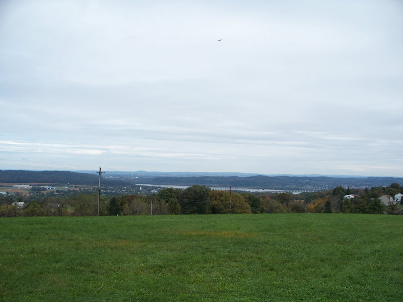
Samuel S. Lewis State Park, PA, with its scenic overlook of the Susquahanna River.

The closer of the two bridges in this photo is at the site of a wooden bridge that was burnt by Federal troops in 1863. They prevented Jubel Early's brigade from crossing the river and attacking either Lancaster or Harrisburg. Lee's orders were to "take" Pennsylvania's capital, and had the troops crossed, they would have defeated the small militia in the city. Instead, they were stuck at York because of the lack of a bridge crossing/ Fortunately for them, Lee was concerned about the Federal army gathering near a small town named Gettysburg, and he called them back to his lines....
The closer of the two bridges in this photo is at the site of a wooden bridge that was burnt by Federal troops in 1863. They prevented Jubel Early's brigade from crossing the river and attacking either Lancaster or Harrisburg. Lee's orders were to "take" Pennsylvania's capital, and had the troops crossed, they would have defeated the small militia in the city. Instead, they were stuck at York because of the lack of a bridge crossing/ Fortunately for them, Lee was concerned about the Federal army gathering near a small town named Gettysburg, and he called them back to his lines....

 Very nice images.
10-25-09, 07:41 AM
Very nice images.
10-25-09, 07:41 AM
#14
Guest
Posts: n/a
Mentioned: Post(s)
Tagged: Thread(s)
Quoted: Post(s)
From my ride around Antietam Battlefield:
At Dunker Church.

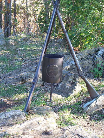
The most overlooked marker at Antietam. A Philadelphia regiment honored their camp coffee-pot. The inscription ends with the phrase "a hot place." Very true, since they were on the edge of the Bloody Cornfield. Antietam was the bloodiest battle in American history till that time, with 23K casualties in about 12 hours.

From the stone observation tower near the Mumma Farm. Antietam has far fewer monuments than Gettysburg, so you get a better feel for the terrain Lee and McClellan fought over.

At the tower:
Burnside Bridge, scene of some of the worst fighting.

The sun was setting as I got back to my car....

At Dunker Church.
The most overlooked marker at Antietam. A Philadelphia regiment honored their camp coffee-pot. The inscription ends with the phrase "a hot place." Very true, since they were on the edge of the Bloody Cornfield. Antietam was the bloodiest battle in American history till that time, with 23K casualties in about 12 hours.
From the stone observation tower near the Mumma Farm. Antietam has far fewer monuments than Gettysburg, so you get a better feel for the terrain Lee and McClellan fought over.
At the tower:
Burnside Bridge, scene of some of the worst fighting.
The sun was setting as I got back to my car....
 10-25-09, 01:13 PM
#16
Guest
Posts: n/a
Mentioned: Post(s)
Tagged: Thread(s)
Quoted: Post(s)
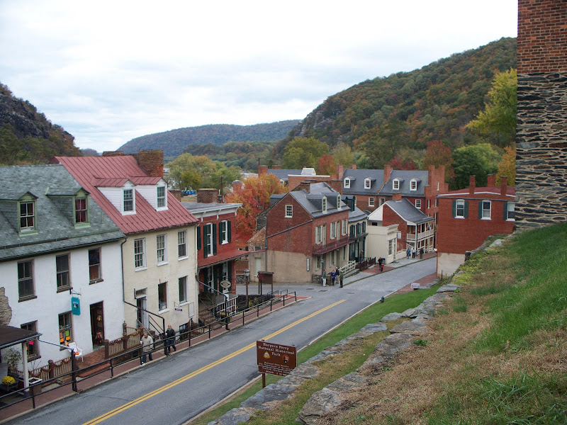
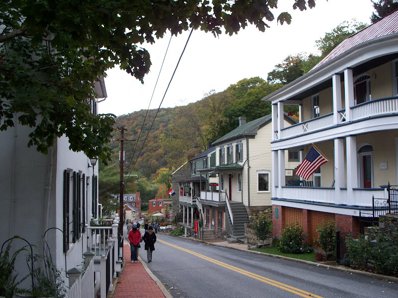
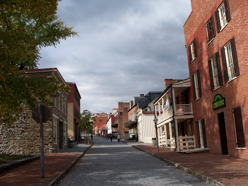
Harpers Ferry is a great place to visit, walk, or hike. Not to bike, in my opinion. It's too hilly, the NPS has a large list of restrictions on bicycles (no riding on sidewalks or trails, no riding down to the historic section of town from the park visitor center, etc), RT 340 across the Potomac and Shenandoah are not bike friendly, and the pedestrian bridge from the C & O Canal Towpath has a spiral stairway that pretty much requires you to carry the bike overhead. If you want to see town, drive to the visitor center and take the NPS shuttle bus down, or lock your bike at the rack on the towpath and walk across the river.
Marine color guard at the wreath-laying for Pvt. Luke Quinn, killed during the capture of John Brown 150 years ago.
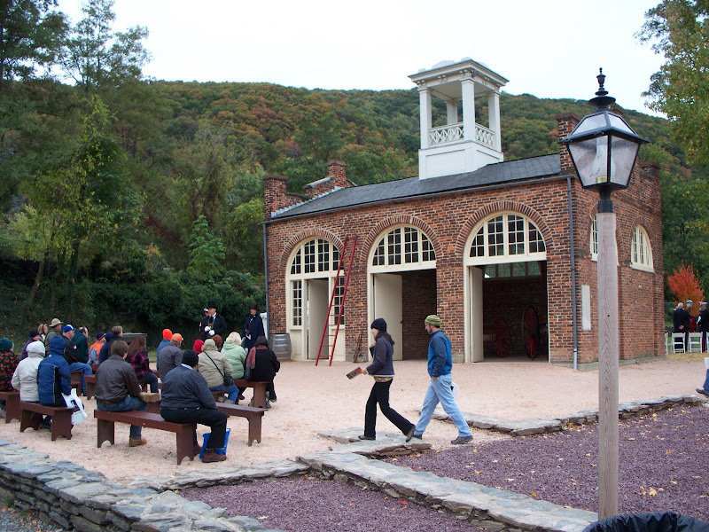
The Federal Armory's enginehouse, often called "John Brown's Fort." This is where the raiders made their last stand. It's been moved several times over the past 150 years, and currently is about a quarter mile from its 1859 location.
A few hundred feet from the fort, you can see the confluence of the Potomac and Shenandoah. Thomas Jefferson described the view as so spectacular, it was worth crossing the ocean to see. (Washington, DC, is 60 miles down the river.) "Jefferson Rock", the vantage point he had, was far too high for me to hike to during my afternoon in town. I'll be back, however, so I'll see it next trip.

Marine color guard at the wreath-laying for Pvt. Luke Quinn, killed during the capture of John Brown 150 years ago.
The Federal Armory's enginehouse, often called "John Brown's Fort." This is where the raiders made their last stand. It's been moved several times over the past 150 years, and currently is about a quarter mile from its 1859 location.
A few hundred feet from the fort, you can see the confluence of the Potomac and Shenandoah. Thomas Jefferson described the view as so spectacular, it was worth crossing the ocean to see. (Washington, DC, is 60 miles down the river.) "Jefferson Rock", the vantage point he had, was far too high for me to hike to during my afternoon in town. I'll be back, however, so I'll see it next trip.
