


Trip report: RAW / Ride Around Washington 2014
 08-11-14, 05:17 PM
#1

Senior Member
Thread Starter

Trip report: RAW / Ride Around Washington 2014
For the past several years, I've spent a week of summer vacation bicycle touring. I started out with self-supported rides on rail-trail conversions, because I didn't have the strength for hills. (2010, GAP/C&O; 2011, P'tit Train du Nord) 2012 was my first group tour, riding the Bon Ton Roulet in the Finger Lakes region of NY State. And last year, I overestimated my abilities when I tried Skyline Drive in the Shenandoah National Park.
This year, I wanted to try something with more hills; something with group support, so I wouldn't need to carry 40 pounds of camping gear with me on those hills. Ideally, I'd avoid rain and stay away from temperatures over, say, 85*F/30*C. After spending some time looking at rides on the bikingbis.com website, I found a winner: the Ride Around Washington (RAW), sponsored by the Cascade bicycle club.
RAW takes a different route every year, visiting different parts of Washington State. This year, the focus was on the Olympic Peninsula. We'd ride sort of anti-clockwise around the state from La Conner, a town northeast of Seattle. Keeping the Olympic mountains in view just about the whole time, we'd get ocean breezes as well. 400 miles, 15000+ feet of elevation gain, in an area where the average daily rainfall in the beginning of August is 0.04 inches.
I'll post more about the ride and route later; but let me start off by telling you all how well-organized the trip was. Next year, the ride will be in a different part of the state, so having me tell you about the sights along my ride won't help you know how good next year's ride will be. Telling you about the organization, though, will be useful no matter when you're thinking of heading out with RAW.
Cascade provided three meals a day; two extra rest stops; and camping in different towns. They shuttled our gear from town to town while we rode. In an area where road services were few and far between, they carted water tanks in pickup trucks from rest stop to rest stop to make sure we stayed hydrated. Of course they scouted the roads in advance, deciding on the route; on top of that, they rechecked the route the day before, making on-the-fly changes where possible around construction and gravel. They coordinated getting the entire caravan of 250+ riders and several support trucks onto a single ferry, so we could keep together as we crossed Puget Sound. In areas where there was only one road for all traffic -- no "main" road vs "back" road -- organizers called the local timber companies to make sure the folks driving logging trucks knew we'd be out there.
Food came from a catering company that had a tractor-trailer-kitchen as part of our caravan. We had hot breakfasts and hot dinners, with omnivore and vegetarian options. Lunches were sandwiches that were shuttled to the designated lunch stop in coolers. On the morning when riders woke up at 4am to be on the ferry on time, the kitchen staff started making our lunches ay 2am.
Another tractor-trailer was adapted as a mobile shower. At the end of a day of riding, we were all guaranteed a hot shower if we wanted one -- and we did. How the water heaters kept up with the demand I don't know, but I never had a problem getting hot water.
Cascade let riders know far in advance what the climate was like in that area in August, and suggested items I never would have thought to pack otherwise. Arm warmers and leg warmers, which I had never used before, were essential on the mornings when we set out in 50*F fog-covered mornings -- which eventually gave way to 80*F cloudless skies. At every rest stop, we had the opportunity to leave behind any gear or clothing we thought we wouldn't need the rest of the day; the staff would carry it to the day's destination for us.
They organized shuttle service for the riders, our bikes, and the rest of our gear from Seattle to La Connor, where the ride actually began; and another ride from Ilwaco, the end of the ride, back to Seattle.
Of course, a bicycle mechanic was part of the caravan -- but I didn't expect that three massage therapists would be joining us too!
I can't say what the sights will be on the 2015 RAW, but with the organizational team Cascade has, I'm certain it will be well-planned, well-supported, and well-executed.
(Key words for this thread: Cascade Bicycle Club, RAW, RIde Around Washington, ride report, trip report, ride review )
__________________
- Jeneralist
- Jeneralist
Last edited by jeneralist; 08-22-14 at 04:28 AM. Reason: Added key words to make it easire for search engines )
 08-11-14, 06:00 PM
#2
Senior Member
Thread Starter
Day 1: Seattle to La Conner by bus; then La Conner to Coupeville (47 miles, 2991 ft)
I had arrived in Seattle the day before the ride started, bringing my clothes and my camping gear with me on the flight from the East Coast. I sent my bike on ahead, to be delivered to Cascade's office; they had already let me know that it had arrived. (US Airways wanted $150 each way to carry the bike -- I figured I could do better than that!)
Sunday morning, the riders who didn't want to go straight to La Conner met up at a parking lot on the University of Washington's campus in Seattle. I schlepped my gear from my hotel on the bus; the mile and a half seemed just a bit too far to carry everything. Fortunately, Seattle's mass transit system seems to run starting at 6am even on the weekends.
At the meeting place, folks waited politely to load their bikes onto the trailer that would carry them to the starting line.
Other gear got loaded onto smaller trucks, and comfortable buses were waiting to shuttle us to the beginning of the ride itself. I was a bit concerned at this stage: my bike was still disassembled in its shipping container, and the mechanic who would be helping me re-assemble it was in La Conner, not Seattle. Because I got to the meeting point in Seattle early, I was on the first bus to La Conner, arriving ahead of other riders, their bikes, and my bike box.
It turns out, I didn't need to worry. The bike that had taken me 40 minutes to disassemble and pack on my porch in Philadelphia took Gary, the ride mechanic, a whole 10 minutes to reassemble -- and that included truing the wheels.

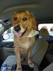
I added in my water bottles, made sure that my mascot (Douglas, a weather-predicting groundhog) had a good view, and by 10:30 or so I was ready to get under way. As we left the parking lot, we were met by Charles, one of the Cascade volunteers, who gave us a quick briefing on how the roads would be marked on the ride. Sure, we had our cue sheets; but there were also painted blazes ("Dan Henrys", they called them) on the road identifying turns. Every now and then, there would also be markings indicating "just keep going straight; you're on the trail and doing fine", which I very much appreciated.
Gentle readers, I was not prepared for this ride. Oh, sure, I had trained on hills. I'd had the elevation profiles for the ride months in advance, and had been making sure to take rides in the hilly areas around my home when I had the change. What I wasn't prepared for was scenes like this:

See, where I grew up (New Jersey), the oceanfront is flat. The only obstacles on beachfront rides are the pedestrians going back and forth from the ice-cream stand to the bar. There are no hills; there are no trees; there is only sand, with maybe a few scrub grasses to give some color to the scene. There certainly aren't any mountains nearby. OMG, that mountain has snow!

We rode for 47 miles that day, with more elevation gain than I'd ever had in one day's ride. There was one hill where I walked the bike -- but I was pleased to see that I wasn't the only one who had dismounted. I got to camp tired but happy, as the organizers let us know it might be a good idea if we woke up at 4am the next day. We'd need to be on the road by 6am to make the ferry off the island.
Who knew that my "secret weapon" would be that I was still on Eastern time? 4am in Washington was 7am back home -- that shouldn't be a problem, right?
Sunday morning, the riders who didn't want to go straight to La Conner met up at a parking lot on the University of Washington's campus in Seattle. I schlepped my gear from my hotel on the bus; the mile and a half seemed just a bit too far to carry everything. Fortunately, Seattle's mass transit system seems to run starting at 6am even on the weekends.
At the meeting place, folks waited politely to load their bikes onto the trailer that would carry them to the starting line.
Other gear got loaded onto smaller trucks, and comfortable buses were waiting to shuttle us to the beginning of the ride itself. I was a bit concerned at this stage: my bike was still disassembled in its shipping container, and the mechanic who would be helping me re-assemble it was in La Conner, not Seattle. Because I got to the meeting point in Seattle early, I was on the first bus to La Conner, arriving ahead of other riders, their bikes, and my bike box.
It turns out, I didn't need to worry. The bike that had taken me 40 minutes to disassemble and pack on my porch in Philadelphia took Gary, the ride mechanic, a whole 10 minutes to reassemble -- and that included truing the wheels.
I added in my water bottles, made sure that my mascot (Douglas, a weather-predicting groundhog) had a good view, and by 10:30 or so I was ready to get under way. As we left the parking lot, we were met by Charles, one of the Cascade volunteers, who gave us a quick briefing on how the roads would be marked on the ride. Sure, we had our cue sheets; but there were also painted blazes ("Dan Henrys", they called them) on the road identifying turns. Every now and then, there would also be markings indicating "just keep going straight; you're on the trail and doing fine", which I very much appreciated.
Gentle readers, I was not prepared for this ride. Oh, sure, I had trained on hills. I'd had the elevation profiles for the ride months in advance, and had been making sure to take rides in the hilly areas around my home when I had the change. What I wasn't prepared for was scenes like this:
See, where I grew up (New Jersey), the oceanfront is flat. The only obstacles on beachfront rides are the pedestrians going back and forth from the ice-cream stand to the bar. There are no hills; there are no trees; there is only sand, with maybe a few scrub grasses to give some color to the scene. There certainly aren't any mountains nearby. OMG, that mountain has snow!
We rode for 47 miles that day, with more elevation gain than I'd ever had in one day's ride. There was one hill where I walked the bike -- but I was pleased to see that I wasn't the only one who had dismounted. I got to camp tired but happy, as the organizers let us know it might be a good idea if we woke up at 4am the next day. We'd need to be on the road by 6am to make the ferry off the island.
Who knew that my "secret weapon" would be that I was still on Eastern time? 4am in Washington was 7am back home -- that shouldn't be a problem, right?
__________________
- Jeneralist
- Jeneralist
Last edited by jeneralist; 08-11-14 at 08:29 PM. Reason: fixed link to pic of snow-capped mountain
08-12-14, 08:06 AM
#3
SuperGimp
It sounds like you had a great time - how was the level of support compared to the finger lakes ride you did? Did you have them set up/ take down and transport your tent?
08-12-14, 12:54 PM
#4
Senior Member

Join Date: Oct 2011
Location: Ellensburg,WA
Posts: 3,179
Bikes: Schwinn Broadway, Specialized Secteur Sport(crashed) Spec. Roubaix Sport, Spec. Crux
Mentioned: 7 Post(s)
Tagged: 0 Thread(s)
Quoted: 179 Post(s)
Liked 167 Times
in
83 Posts
I'm happy to read you enjoyed your trip through my state! I look forward to reading more about the ride jeneralist. I had to laugh that you choose Washington to avoid rain and the route went through our rain forest, although historically you did come the one week it rarely rains.
__________________
Sir Mark, Knight of Sufferlandria
Sir Mark, Knight of Sufferlandria
08-12-14, 04:23 PM
#5
Senior Member
Thread Starter
One advantage of keeping things small, though, was a service that the Bon Ton didn't offer: an official charging table! At overnight stops, riders on the Bon Ton would disperse through the open areas of whatever school we were camping at, hunting for outlets so we could charge our electronic gear. The RAW was small enough that they could make charging an official feature of the ride:
The availability of AC power and the small number of riders also meant that RAW was able to accomodate participants' CPAP machines. Each night's camp had a special CPAP section where folks with sleep apnea could have electricity during the night for their breathing devices.
__________________
- Jeneralist
- Jeneralist
08-12-14, 04:25 PM
#6
Senior Member
Thread Starter
I'm happy to read you enjoyed your trip through my state! I look forward to reading more about the ride jeneralist. I had to laugh that you choose Washington to avoid rain and the route went through our rain forest, although historically you did come the one week it rarely rains.
__________________
- Jeneralist
- Jeneralist
08-12-14, 05:09 PM
#7
Senior Member
Thread Starter
Day 2: Coupeville to Port Angeles, 70 miles, 3621 feet climbing
We really did wake up at 4am that morning, to be able to be at the ferry at 6:30. The sky was dark, and mist had settled over the island. By the time I had gotten dressed for the early ride -- with arm warmers, leg warmers, and a cap under my helmet -- the sun had risen to the point that I could see to take down the tent. By 6, we had all loaded our gear onto the trucks and left the campsite.
The loadmaster for the ferry had a rough job that morning: how do you keep the ship balanced while you load trucks on board, to be balanced against 250 bikes? As we queued, waiting for our ship to come in, I half expected to hear an announcement of, "OK, everyone with steel bikes to the left side; titanium to the right; carbon fiber needs to go in the middle...."


When we docked in Port Townsend, we had the only mass start of the week as we all made our way off the ferry and on to the Olympic Discovery Trail. Over the course of the day, we'd go back and forth between the trail (packed dirt & gravel) and the local roads and highways. Since several of the local roads were chip-seal rather than smooth asphalt, there were times that the trail was a nicer surface than the pavement!
The route kept close to the ocean, but that didn't mean it was flat. We'd ride down just to the verge of the water, then turn up and inland up a cliff. (At least, that's what it seemed like to East-Coast me.) One memorable section had what felt to be a 3-4% grade of old chipseal. Just when the grade increased to 6-7%, the road department had done some maintenance and put down new sealer and a fresh layer of loose gravel. I walked the bike on that section.
The trail led through evergreen forest, over streams and rivers.


After crossing one bridge, a rider who lived locally suggested that I stop my bike and have a look at something I had noted without understanding what it was:

She explained that I was looking at a salmon trap. The stream flows from the bottom of the picture to the top; salmon returning to their spawning areas swim against the current, from the top of the picture to the bottom -- and find the way blocked by a fence. Salmon are going to swim upstream; they don't turn around. So eventually, salmon accumulate behind the fence, and someone from the local hatchery collects them. In a process that may involve mood lighting and Barry White music, the fish are induced to spawn; the fry are collected; and the adult fish are returned to the stream.
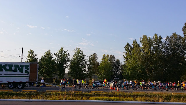
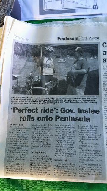
The next day, I discovered that we had an extra rider with us on the ride into Port Angeles: Washington's governor, Jay Inslee, is an avid cyclist. He joined the ride for the day, even daring to have his photograph taken in lycra riding shorts. That's how you know that the government supports cycling infrastructure!
With a day's practice already behind us, our tent city sprang up more quickly than it had in Coupeville. We had already learned who brought a hammer for the tent stakes, and which brand of beer they favored.

The loadmaster for the ferry had a rough job that morning: how do you keep the ship balanced while you load trucks on board, to be balanced against 250 bikes? As we queued, waiting for our ship to come in, I half expected to hear an announcement of, "OK, everyone with steel bikes to the left side; titanium to the right; carbon fiber needs to go in the middle...."
When we docked in Port Townsend, we had the only mass start of the week as we all made our way off the ferry and on to the Olympic Discovery Trail. Over the course of the day, we'd go back and forth between the trail (packed dirt & gravel) and the local roads and highways. Since several of the local roads were chip-seal rather than smooth asphalt, there were times that the trail was a nicer surface than the pavement!
The route kept close to the ocean, but that didn't mean it was flat. We'd ride down just to the verge of the water, then turn up and inland up a cliff. (At least, that's what it seemed like to East-Coast me.) One memorable section had what felt to be a 3-4% grade of old chipseal. Just when the grade increased to 6-7%, the road department had done some maintenance and put down new sealer and a fresh layer of loose gravel. I walked the bike on that section.
The trail led through evergreen forest, over streams and rivers.
After crossing one bridge, a rider who lived locally suggested that I stop my bike and have a look at something I had noted without understanding what it was:
She explained that I was looking at a salmon trap. The stream flows from the bottom of the picture to the top; salmon returning to their spawning areas swim against the current, from the top of the picture to the bottom -- and find the way blocked by a fence. Salmon are going to swim upstream; they don't turn around. So eventually, salmon accumulate behind the fence, and someone from the local hatchery collects them. In a process that may involve mood lighting and Barry White music, the fish are induced to spawn; the fry are collected; and the adult fish are returned to the stream.
The next day, I discovered that we had an extra rider with us on the ride into Port Angeles: Washington's governor, Jay Inslee, is an avid cyclist. He joined the ride for the day, even daring to have his photograph taken in lycra riding shorts. That's how you know that the government supports cycling infrastructure!
With a day's practice already behind us, our tent city sprang up more quickly than it had in Coupeville. We had already learned who brought a hammer for the tent stakes, and which brand of beer they favored.
__________________
- Jeneralist
- Jeneralist
08-13-14, 08:00 AM
#8
Senior Member
Join Date: Jan 2010
Posts: 39,220
Mentioned: 211 Post(s)
Tagged: 1 Thread(s)
Quoted: 18403 Post(s)
Liked 15,495 Times
in
7,317 Posts
Sounds like fun. Maybe they will do the N. Cascades Highway next year. That's a beautiful ride.
Did the Bon Ton this for the first time since '06. I was pleasantly surprised to find that the event s better supported than it was when I did it in '06.
Did the Bon Ton this for the first time since '06. I was pleasantly surprised to find that the event s better supported than it was when I did it in '06.
08-13-14, 04:21 PM
#10
Senior Member
Thread Starter
The ride this year ended in Ilwaco, where the Columbia river meets the Pacific Ocean. I believe that next year, they're planning a ride from Ilwaco to Walla Walla, tracking the river upstream; 2016 will be headed north from Walla Walla up to the northeast corner of the state; and 2017 will be following Rt 20 from east to west, ending in La Conner -- where this ride began. The full four year cycle will truly be a ride around Washington.
__________________
- Jeneralist
- Jeneralist
08-13-14, 05:16 PM
#11
Senior Member
Thread Starter
Day 3: Resting in Port Angeles
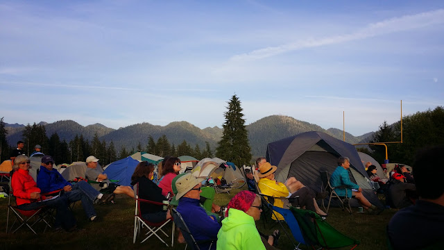
And on the third day, we rested.
Some of the riders found it odd to have our rest day come so early in the week. By stopping in Port Angeles, though, the riders could do more than merely rest. Many took the ferry across the Strait of Juan de Fuca to Victoria, BC. Others took advantage of a 50 mile loop route that Cascade had set up for us: even if we'd be on our own for rest stops and such, the cue sheet highlighted convenience stores along the way. Some went into town, visiting small shops, microbreweries, or laundromats. And for about 30 riders, there was Hurricane Ridge.
If you head south out of Port Angeles on Hurricane Ridge Rd, you are treated to an 18 mile stretch of asphalt into the Olympic Mountains, and into Olympic National Park. At the group assembly the night before, we were told to allow 3 hours for the ride up -- and one hour for the ride back down. Along those 18 miles, you gain a little over a mile in elevation. That works out to a 5.5% average slope. Of course, the hill is steeper in some sections than others. RidewithGPS shows a few sections that are 9% inclines. There's a ranger station at the top of the climb, where you can get something to eat or drink, or just sit and admire the views.
(I apologize for the ads that my photo service has started putting at the bottom of linked pics. For these, though, I think the extra size makes the banner ads worth it.)

If you know where to look (about 1/3 of the way from the right border of the picture) you can see a glacier:

The ranger station highlights something I already knew: Olympic National Park is one of the only places in the world to see the endangered Olympic Mountain marmot. These cousins of the more common groundhog live above the treeline (no wood for these woodchucks to chuck!) in the Olympic mountains. With my mascot in my backpack, I set out along one of the hiking trails in hopes of seeing one of these rodents of unusual size. Of course, the hike had its own rewards.
Looking north to the straits:

Getting above the treeline:

And then I waited. And waited some more. And realized that I didn't have any water with me. And waited... and then I heard someone above me on the trail say, "Hey, I didn't know they had beavers up here."

Click here for animated gif
Delighted, I set off down the trail, heading back to the ranger station.

I got back in time to take a nap -- this was supposed to be a rest day, after all -- before heading into downtown Port Angeles to a microbrewery that was giving away the first round free for RAW riders. Then back to the campsite for dinner, a few minutes of just watching the clouds, and bedtime.
Oh, and if you're wondering how someone who walked her bike up a short 9% incline the day before managed the 18 mile climb up Hurricane Ridge, you should know that Port Angeles has many of the amenities of larger cities, including car rental offices.
Some of the riders found it odd to have our rest day come so early in the week. By stopping in Port Angeles, though, the riders could do more than merely rest. Many took the ferry across the Strait of Juan de Fuca to Victoria, BC. Others took advantage of a 50 mile loop route that Cascade had set up for us: even if we'd be on our own for rest stops and such, the cue sheet highlighted convenience stores along the way. Some went into town, visiting small shops, microbreweries, or laundromats. And for about 30 riders, there was Hurricane Ridge.
If you head south out of Port Angeles on Hurricane Ridge Rd, you are treated to an 18 mile stretch of asphalt into the Olympic Mountains, and into Olympic National Park. At the group assembly the night before, we were told to allow 3 hours for the ride up -- and one hour for the ride back down. Along those 18 miles, you gain a little over a mile in elevation. That works out to a 5.5% average slope. Of course, the hill is steeper in some sections than others. RidewithGPS shows a few sections that are 9% inclines. There's a ranger station at the top of the climb, where you can get something to eat or drink, or just sit and admire the views.
(I apologize for the ads that my photo service has started putting at the bottom of linked pics. For these, though, I think the extra size makes the banner ads worth it.)
If you know where to look (about 1/3 of the way from the right border of the picture) you can see a glacier:
The ranger station highlights something I already knew: Olympic National Park is one of the only places in the world to see the endangered Olympic Mountain marmot. These cousins of the more common groundhog live above the treeline (no wood for these woodchucks to chuck!) in the Olympic mountains. With my mascot in my backpack, I set out along one of the hiking trails in hopes of seeing one of these rodents of unusual size. Of course, the hike had its own rewards.
Looking north to the straits:
Getting above the treeline:
And then I waited. And waited some more. And realized that I didn't have any water with me. And waited... and then I heard someone above me on the trail say, "Hey, I didn't know they had beavers up here."
Click here for animated gif
Delighted, I set off down the trail, heading back to the ranger station.
I got back in time to take a nap -- this was supposed to be a rest day, after all -- before heading into downtown Port Angeles to a microbrewery that was giving away the first round free for RAW riders. Then back to the campsite for dinner, a few minutes of just watching the clouds, and bedtime.
Oh, and if you're wondering how someone who walked her bike up a short 9% incline the day before managed the 18 mile climb up Hurricane Ridge, you should know that Port Angeles has many of the amenities of larger cities, including car rental offices.
__________________
- Jeneralist
- Jeneralist
08-13-14, 11:14 PM
#12
Just Keep Pedaling

Join Date: Mar 2012
Location: Lakewood, CA
Posts: 3,355
Bikes: 99 Schwinn Mesa GS MTB, 15 Trek Domane 5.9 Dura-Ace, 17 Trek Emonda SL6 Pro & 18 Bianchi Vigorelli
Mentioned: 30 Post(s)
Tagged: 0 Thread(s)
Quoted: 251 Post(s)
Likes: 0
Liked 67 Times
in
34 Posts
As a native Washingtonian...these RAW rides are on my bucket list. Keep the ride report coming! Enjoying all the trip so far
08-13-14, 11:28 PM
#13
Senior Member
Join Date: Jan 2014
Location: Seattle, WA
Posts: 73
Bikes: Seven Evergreen, Co-Motion Americano
Mentioned: 0 Post(s)
Tagged: 0 Thread(s)
Quoted: 0 Post(s)
Likes: 0
Liked 0 Times
in
0 Posts
This is great stuff, keep it coming!
I live here in Washington, and RAW is something I would really like to do on the next go round.
I live here in Washington, and RAW is something I would really like to do on the next go round.
08-13-14, 11:44 PM
#14
SuperGimp
 08-14-14, 06:17 AM
#15
Senior Member

I have only gotten to Day 2 and scrolled through the pictures, but need to shut down PC. Couldn't wait until later to post - thanks so much for posting this. A multi-day tour is in my biking bucket list. I'm reading your intro and thinking "this is a good writeup; I could be reading this in a glossy magazine at the grocery store."
// Zoxe
// Zoxe
08-14-14, 07:32 AM
#16
Senior Member
Join Date: Jan 2010
Posts: 39,220
Mentioned: 211 Post(s)
Tagged: 1 Thread(s)
Quoted: 18403 Post(s)
Liked 15,495 Times
in
7,317 Posts
If you don't mind large events (about 2,200 people), you might want to check out Cycle Oregon next year. The routes are usuaully fantastic. This year's route has over 30,000 feet of climbing, so next year's route might be an easier one. The 2015 route will be announced in February of that year.
08-14-14, 02:44 PM
#17
Senior Member

Join Date: Sep 2009
Location: Seattle, WA
Posts: 223
Bikes: 198? Colnago, 2010 Jamis Quest, 2013 Wabi Classic 46x18
Mentioned: 0 Post(s)
Tagged: 0 Thread(s)
Quoted: 0 Post(s)
Likes: 0
Liked 0 Times
in
0 Posts
Thanks for the ride report! Keep the posts coming--you're making me seriously think about doing RAW, even though most of the time I am a strict no-camping person...
08-14-14, 08:47 PM
#18
Senior Member
Thread Starter
Day 4: Port Angeles to Forks (66 miles, 3176 feet climbing)
By the fourth day, I was moving through the ride with a predictable rhythm. I'd wake up around dawn; get dressed in my biking gear, with arm warmers, leg warmers, and a jacket; then bypass the hot breakfast line to grab some yogurt and granola. (My stomach refuses to really wake up until an hour or two after the rest of me.) Then pack up the tent and drop off my bags with at the truck before setting out for the day's ride. The morning fog would burn off in two or three hours. That would be my cue to start taking off all those extra layers. I'd amble through the ride, in no rush to go past the marvelous scenery, getting back to camp a bit before our 5pm SAG deadline. A shower, a delicious hot dinner, an evening briefing, and then to bed at sunset.
For some of the riders I was with, there was an extra element to the day's plans: get the bike ready for Forks. I don't mean making sure that the tires are inflated to the right pressure, or that your red blink-taillights are working well. No, I mean something extra for the town of Forks itself, the setting for the Twilight series of books. There would be a vampire-related costume contest at the evening meeting when we got into town. Some of the cyclists got an early jump on things by decorating their bikes:

For me, it was one of the more nerve-wracking days of the ride. By this point, we had left the bike trails behind and were riding almost completely on highways. The cue sheet had far more instructions to "continue straight" than there were turns. There was no such thing as "back road" any more; there was only the road, and we had to share it with RVs and logging trucks. One logging truck -- or more accurately, the driver of one logging truck -- was giving some of the riders a hard time that morning. He'd drive to just behind a cyclist, then let rip with his air horn before creeping over 6 inches to pass as closely and and sullenly as he could. A few of the riders who endured his attentions mentioned it to ride organizers, and to other truckers, at the first rest stop of the day. After that, word likely spread along the drivers, and there were no more incidents.
Adding to my trepidation was something I had named to myself as Halfway Hill. You'll remember that the ride started along the islands and northern shore of Washington, next to the straight of Juan de Fuca. Wednesday's ride marked the shift to the Pacific coast. We didn't ride all the way around the coastline: there just weren't any roads that hugged the coast southwards from that northwestern tip of the state. Instead, we tracked inland, into the hills.

Folks who ride long hills regularly will smile when they see the elevation profile that had me scared. Because RAW is so well organized, I had been looking at this sheet for months, tryng to find hills in my area that are comparable to the incline between about mile 43 and mile 47:

What really scared me, I think, was that this was one hill that I couldn't just walk. It was long enough that walking it might take me an hour -- an hour with who knew what kind of shoulder, in what kind of traffic. So I had over-anticipated the peak of "Halfway Hill", marked with the name of the highway on the map above. The lunch stop was at mile 40, and knowing how poorly I ride after a big meal, I had written "DO NOT EAT" on that line of the cue sheet. I got to the lunch stop, grabbed my sandwich and a bag of chips, refilled my water bottles, and started pedalling.
The first few miles after the lunch stop were easy, as I expected them to be, except for the nervous anticipation. When would the incline change? When would the real hill start? The few clouds there were drifted away, and I was under the sun's full noontime glare. Where was the hill? Should I leave one foot un-clipped from my pedals, so that if I got into trouble I could touch down without falling over?
Then, there it was, and I was on my way up, slowly. I felt like I was going slowly enough that I wouldn't be able to coordinate reaching for a water bottle without stopping, and I was afraid to stop for fear I wouldn't get started again. I've got a granny gear that's 28 in the front, 34 in the back, and with it I was finding out just how slowly I could ride without falling over. It wasn't hard, in the muscle sense; but I had gotten myself so worked up about it that even something the slope of a rail-trail could have felt impossible along that stretch.
Finally, I turned the corner from Rt 112 to Rt 113. A genuine stop sign gave me an excuse to put both feet down, grab my water bottle, and drink deeply. Then back into the cleats and -- FRAK! MORE HILL!
This made no sense to me. Wouldn't the road start turning down at the intersection? From that point on, every time I got to a bend in the road where I could see a bit farther -- and see that the road kept going uphill -- I'd stop and have a sip of Gatorade. Something about the sweetness helped. Maybe I was giving my whining inner child a lollipop to get her to keep quiet.
Of course, eventually the hill did reach an apex, and I started rolling down southwards. At the first spot where the shoulder was a bit wider than usual, where there was some shade, I spotted two riders pulled over having lunch. Heartened that I hadn't been the only one who deferred eating until after the hill, I joined them, enjoying the barbeque tofu wrap that I had picked up 10 miles -- and 10000 whines -- before.
For some of the riders I was with, there was an extra element to the day's plans: get the bike ready for Forks. I don't mean making sure that the tires are inflated to the right pressure, or that your red blink-taillights are working well. No, I mean something extra for the town of Forks itself, the setting for the Twilight series of books. There would be a vampire-related costume contest at the evening meeting when we got into town. Some of the cyclists got an early jump on things by decorating their bikes:
For me, it was one of the more nerve-wracking days of the ride. By this point, we had left the bike trails behind and were riding almost completely on highways. The cue sheet had far more instructions to "continue straight" than there were turns. There was no such thing as "back road" any more; there was only the road, and we had to share it with RVs and logging trucks. One logging truck -- or more accurately, the driver of one logging truck -- was giving some of the riders a hard time that morning. He'd drive to just behind a cyclist, then let rip with his air horn before creeping over 6 inches to pass as closely and and sullenly as he could. A few of the riders who endured his attentions mentioned it to ride organizers, and to other truckers, at the first rest stop of the day. After that, word likely spread along the drivers, and there were no more incidents.
Adding to my trepidation was something I had named to myself as Halfway Hill. You'll remember that the ride started along the islands and northern shore of Washington, next to the straight of Juan de Fuca. Wednesday's ride marked the shift to the Pacific coast. We didn't ride all the way around the coastline: there just weren't any roads that hugged the coast southwards from that northwestern tip of the state. Instead, we tracked inland, into the hills.
Folks who ride long hills regularly will smile when they see the elevation profile that had me scared. Because RAW is so well organized, I had been looking at this sheet for months, tryng to find hills in my area that are comparable to the incline between about mile 43 and mile 47:
What really scared me, I think, was that this was one hill that I couldn't just walk. It was long enough that walking it might take me an hour -- an hour with who knew what kind of shoulder, in what kind of traffic. So I had over-anticipated the peak of "Halfway Hill", marked with the name of the highway on the map above. The lunch stop was at mile 40, and knowing how poorly I ride after a big meal, I had written "DO NOT EAT" on that line of the cue sheet. I got to the lunch stop, grabbed my sandwich and a bag of chips, refilled my water bottles, and started pedalling.
The first few miles after the lunch stop were easy, as I expected them to be, except for the nervous anticipation. When would the incline change? When would the real hill start? The few clouds there were drifted away, and I was under the sun's full noontime glare. Where was the hill? Should I leave one foot un-clipped from my pedals, so that if I got into trouble I could touch down without falling over?
Then, there it was, and I was on my way up, slowly. I felt like I was going slowly enough that I wouldn't be able to coordinate reaching for a water bottle without stopping, and I was afraid to stop for fear I wouldn't get started again. I've got a granny gear that's 28 in the front, 34 in the back, and with it I was finding out just how slowly I could ride without falling over. It wasn't hard, in the muscle sense; but I had gotten myself so worked up about it that even something the slope of a rail-trail could have felt impossible along that stretch.
Finally, I turned the corner from Rt 112 to Rt 113. A genuine stop sign gave me an excuse to put both feet down, grab my water bottle, and drink deeply. Then back into the cleats and -- FRAK! MORE HILL!
This made no sense to me. Wouldn't the road start turning down at the intersection? From that point on, every time I got to a bend in the road where I could see a bit farther -- and see that the road kept going uphill -- I'd stop and have a sip of Gatorade. Something about the sweetness helped. Maybe I was giving my whining inner child a lollipop to get her to keep quiet.
Of course, eventually the hill did reach an apex, and I started rolling down southwards. At the first spot where the shoulder was a bit wider than usual, where there was some shade, I spotted two riders pulled over having lunch. Heartened that I hadn't been the only one who deferred eating until after the hill, I joined them, enjoying the barbeque tofu wrap that I had picked up 10 miles -- and 10000 whines -- before.
__________________
- Jeneralist
- Jeneralist
08-14-14, 09:08 PM
#19
Senior Member
Thread Starter
Evening in Forks
Forks was the first town on the route where we set up camp somewhere other than a schoolyard. Because we were no longer on school grounds, we were allowed to have alcohol at the campsite that night. Indeed, on getting to the site we could have a bottle of beer or a glass of wine for free. A glass of red went very well with my minimalist "costume", a black piece of fabric wrapped cape-style around my shoulders.
The contest winners, though, had more than the usual costume ideas to help them out. A group of four people -- three with garbage-bag capes, and one dressed like a jogger -- claimed the prize. "Most of the time," said the jogger, when it was his turn at the microphone, "I look like anyone else in the Pacific Northwest. Active, healthy, green. But in Forks, I turn into a vampire slayer!" He took off the jacket from his 80s-style jogging outfit, revealing a silvered jacket underneath. "And the vampires that I kill are --- flat tires! broken chains! headwinds!" His 'stake' was a long, heavy Allen wrench, as he went after companions -- one with an inner tube, one who was holding a section of bike chain, and one with a wig of brightly-colored tubes that bobbed in the breeze.
Because we were in a park in the middle of town, some of us felt a bit more nervous about our bikes than we had at the other overnights. Along with two friends I had made on the trip, I thought I should lock my bike that night -- especially since our tents were right at the edge of the park. Since there weren't any formal bike racks nearby, we "circled the wagons", locking our bikes to each other around a tree.

As it happens, there was a bit of a disturbance that night. Some folks decided to drive their cars around the park honking their horns; others started walking through the encampment until they were challenged by some of the ride organizers. RAW staffers collected all the cell phones that had been left outside charging and locked them inside one of the equipment trucks. Eventually, the police came and cleared away the harassers.
I found out just how good my ear plugs were: I slept through the whole thing.
The contest winners, though, had more than the usual costume ideas to help them out. A group of four people -- three with garbage-bag capes, and one dressed like a jogger -- claimed the prize. "Most of the time," said the jogger, when it was his turn at the microphone, "I look like anyone else in the Pacific Northwest. Active, healthy, green. But in Forks, I turn into a vampire slayer!" He took off the jacket from his 80s-style jogging outfit, revealing a silvered jacket underneath. "And the vampires that I kill are --- flat tires! broken chains! headwinds!" His 'stake' was a long, heavy Allen wrench, as he went after companions -- one with an inner tube, one who was holding a section of bike chain, and one with a wig of brightly-colored tubes that bobbed in the breeze.
Because we were in a park in the middle of town, some of us felt a bit more nervous about our bikes than we had at the other overnights. Along with two friends I had made on the trip, I thought I should lock my bike that night -- especially since our tents were right at the edge of the park. Since there weren't any formal bike racks nearby, we "circled the wagons", locking our bikes to each other around a tree.
As it happens, there was a bit of a disturbance that night. Some folks decided to drive their cars around the park honking their horns; others started walking through the encampment until they were challenged by some of the ride organizers. RAW staffers collected all the cell phones that had been left outside charging and locked them inside one of the equipment trucks. Eventually, the police came and cleared away the harassers.
I found out just how good my ear plugs were: I slept through the whole thing.
__________________
- Jeneralist
- Jeneralist
08-15-14, 07:26 PM
#20
Senior Member
Thread Starter
Day 5: Forks to Amanda Park (65 miles, 1942 ft climbing)
Thursday's ride was as straightforward as it could get: turn left out of the park in Forks; ride along Highway 101 for about 65 miles until you reach Amanda Park; turn left into the high school parking lot.

Of course, those directions don't make mention of the fact that we'd spend part of the day riding along the Pacific shoreline, in the middle of a rainforest.
Yep! Not all rainforests are tropical rainforests. The temperate zone -- "where they have seasons", roughly -- has its own rainforests, and some say that because of the variety in temperatures throughout the year the rainforests of the Pacific Northwest have more ecological diversity, acre for acre, than the Amazon does. Most of the year, the easterly prevailing wind off the Pacific carries moisture over this region. When the moisture hits the Olympic mountains, rain comes down on the western side. The Hoh valley gets an average of 140+ inches of rain a year, plus extra moisture from morning fog. Yet somehow, very little of that rain comes during the beginning of August.
The heavy rains support a lush growth of tall trees. One had its own highway sign as we went through this section of Olympic National Park. "Big Cedar Tree, 0.3 miles" said the sign. I turned left off the main road to see what was, indeed, a big cedar tree.

Or, perhaps, long cedar tree was a better description. Over a millenium old, the tree had been 175 feet tall and almost 20 feet in diameter before a storm in March split the trunk in two.

The upright part of the tree is clinging to life, although the odds are against it thriving again. We keep our fingers crossed.
The lunch stop on Thursday was at a beach in the park, just above the Pacific.

Sitting on the little gravel outcropping, several of us caught sight of three dark shapes moving through the water. We'd see an arc leaping through the waves, spotting a fin on top before it submerged again. One, two, three would surface and dive; then, after a few seconds, the pattern would repeat some distance northwards. I think we were seeing dolphins.
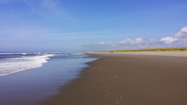
Dolphins or no, I had plenty of reminders that I wasn't at the Jersey Shore this vacation. Jersey doesn't have signs like this near its beaches.

The day's short, flat ride, marred only by some chip-seal roads, meant that I got to the evening campsite earlier than usual. A good portion of the 250 riders celebrated the day by strolling down to a nearby bar for a drink or two before dinner. I feel sorry for the bartender (note use of singular) who had to manage an evening rush far beyond the usual. I noted with delight that I was not the only rider to get a chainring mark on the left leg as we strolled back to the campsite for dinner and the evening meeting.

That night we had a limerick contest. Although I didn't win, I was complimented on my effort:
Of course, those directions don't make mention of the fact that we'd spend part of the day riding along the Pacific shoreline, in the middle of a rainforest.
Yep! Not all rainforests are tropical rainforests. The temperate zone -- "where they have seasons", roughly -- has its own rainforests, and some say that because of the variety in temperatures throughout the year the rainforests of the Pacific Northwest have more ecological diversity, acre for acre, than the Amazon does. Most of the year, the easterly prevailing wind off the Pacific carries moisture over this region. When the moisture hits the Olympic mountains, rain comes down on the western side. The Hoh valley gets an average of 140+ inches of rain a year, plus extra moisture from morning fog. Yet somehow, very little of that rain comes during the beginning of August.
The heavy rains support a lush growth of tall trees. One had its own highway sign as we went through this section of Olympic National Park. "Big Cedar Tree, 0.3 miles" said the sign. I turned left off the main road to see what was, indeed, a big cedar tree.
Or, perhaps, long cedar tree was a better description. Over a millenium old, the tree had been 175 feet tall and almost 20 feet in diameter before a storm in March split the trunk in two.
The upright part of the tree is clinging to life, although the odds are against it thriving again. We keep our fingers crossed.
The lunch stop on Thursday was at a beach in the park, just above the Pacific.
Sitting on the little gravel outcropping, several of us caught sight of three dark shapes moving through the water. We'd see an arc leaping through the waves, spotting a fin on top before it submerged again. One, two, three would surface and dive; then, after a few seconds, the pattern would repeat some distance northwards. I think we were seeing dolphins.
Dolphins or no, I had plenty of reminders that I wasn't at the Jersey Shore this vacation. Jersey doesn't have signs like this near its beaches.
The day's short, flat ride, marred only by some chip-seal roads, meant that I got to the evening campsite earlier than usual. A good portion of the 250 riders celebrated the day by strolling down to a nearby bar for a drink or two before dinner. I feel sorry for the bartender (note use of singular) who had to manage an evening rush far beyond the usual. I noted with delight that I was not the only rider to get a chainring mark on the left leg as we strolled back to the campsite for dinner and the evening meeting.
That night we had a limerick contest. Although I didn't win, I was complimented on my effort:
There was a new rider from Philly
Who searched for some rides that were chilly
She found chip-seal roads
And trucks with their loads
And routes that were happily hilly.
A glass of wine, a lovely dinner, a massage while my phone recharged, and then to sleep. And the days just kept getting better.
Who searched for some rides that were chilly
She found chip-seal roads
And trucks with their loads
And routes that were happily hilly.
__________________
- Jeneralist
- Jeneralist
08-17-14, 05:54 PM
#21
Senior Member
Thread Starter
Day 6: Amanda Park to Raymond (93 miles, 1888 ft climbing)
At 93 miles, our last full day of riding was also our longest. "If you want to do a century, just double back on the route; we'll be looking for you. Slower riders should please be on the road by seven AM," we were told the night before. "We want folks to finish up by five, so our SAG drivers can finish their day. If you're a mile or so from the campsite at the end of the day, we'll let you ride in. If you're ten miles away, you'll be asked to accept a ride on one of our SAG trucks." Even with the extra distance, there were still only three formal rest stops on our route. Morning break as at mile 17; lunch was at mile 47; afternoon break was at mile 71. Given the logistics of the ride, I understand why they didn't just give us an extra rest stop to keep the distances between the breaks shorter. They only had so many trucks to get things set up at each site. The lunch stop was at a town "athletic complex" with plumbing, but the smaller rest stops needed to have water carried in. There were times when a stop would be set up in a slightly wider than usual road shoulder; there just weren't that many places to set things up.
Still, I was nervous. Folks had already commented on the fact that my bike, seemingly alone of all the single-rider bikes there, was set up to carry three water bottles; other folks made do with one or two, or with a camelback-style holder. I had tried a camelback once, and hated the clammy feeling I got on my back under the pack. It didn't help, I suppose, that in my one serious spill (knock wood) I had been wearing a backpack with a few of my college textbooks inside. I hit a curb, flew through the air, and landed on my back. My physics book slammed into the small of my back, giving me urine the color of Hawaiian Punch for a few days. So I kept my back clear. Never mind the fact that I had never drained even two of my water bottles completely anywhere on this ride. The thought of going 30 miles without a rest stop, in unknown (to me) territory, left me looking for ways to bring on extra fluid.
The thought of a 93 mile ride also had me wanting tunes for the road. RAW has a very understandable rule: no headphones. It doesn't matter if they're wired or not, Bluetooth or not -- you need to be able to hear the logging truck coming up behind you. But there was no rule against portable speakers. So when I set out at 6:50 that morning, I made sure that I had a little sound system with me, tucked into the handlebar bag that held my mascot.

The highest elevation for the day was at about 10 miles in. This was one of the rare days with more downhill than up, by about 200 feet. So as I headed out of Amanda Park in grey morning mist, I smiled at the realization that pretty soon, it would all be downhill from there. Our first rest stop was in the hamlet of (I kid you not) Humptulips, which was enough of a town that it had a convenience store. I bought a bottle of iced tea to carry with me. Surely with almost three quarts of liquid, I'd be OK through the thirty-mile gaps.
By about mile 20, I decided it was time to bring on the tunes. Riders nearby smiled when they heard "The Time Warp" from The Rocky Horror Picture Show somewhere along the route. "There Is A Mountain," with the lyric First, there is a mountain/then there is no mountain/then there is pretty well summed up my attitude towards the climbs on the rides; I had Donovan's original, and The Bobs' cover, both with me. Other songs had a role to play: later in the day, as "I Want a New Drug" by Huey Lewis and the News was fading and "Depravity" by Jim's Big Ego was starting up, I saw this sign:

The town name predates the legalization of marijauna by a long margin -- it was named for Chief Toke, who lived in the 19th Century -- but it has taken on a new significance of late.
Lunch was in Aberdeen. After riding through towns that have population measured in the hundreds, it was an adjustment to be back in an area with cross-streets, malls, and traffic. Aberdeen also had headwinds:

The afternoon breeze comes from west to east in that part of the state, and Aberdeen was where we turned west -- right into the wind. At the lunch stop, folks who had seen each other riding for the better part of a week were hurredly looking for others with about the same riding speed. Even those who had never trained for paceline riding were looking to take turns heading into the onshore wind. I was part of a group doing 13-14 mph until we hit the first rise in the road. I kept pedaling, but I didn't keep up. Fortunately, I was at the tail of the line. With a shouted "see you later!" I was back on my own.
Mile 62 marked the spot where we reached the coast and turned south. Again, growing up in an area where "beach" means "boardwalks", I was surprised by how little of the ocean could be seen from the road. Oh, I could hear the water -- it was only a hundred yards or so away -- I just couldn't see it. To my right, where I expected to see sand and surf, there was a little rise dotted with pines and private homes. Not the mansions that would be waterfront property on the Jersey shore; just regular houses built on the rise.
The organizers must have anticipated my frustration at not being able to see the ocean, because they had marked beach access roads on the cue sheet. I stole a few minutes from my sense of "gotta be there by five" urgency to turn off the route and actually get my feet, and my tires, wet:


It turns out that the organizers had actually done much better than that. The afternoon rest stop, at a spot along Rt 105 where the shoulder was wide enough to park a truck and set up a porta-john, overlooked the ocean. We were there at low tide, and shorebirds were coming to feed.


Spending time there just luxurating in the beauty of it all, I lost any sense of urgency I might have had. I was in a world of miracle and wonder, and I could experience it in stillness or in motion as I chose.
The path turned eastward; what had been a headwind became a tailwind; and the day unfolded as it should.


After some amount of riding, I arrived in Raymond. Then I turned back on my own path and rode a bit more. When I reached the park that was our campsite for the night, it was 4:50pm and I had ridden 100.4 miles.
Still, I was nervous. Folks had already commented on the fact that my bike, seemingly alone of all the single-rider bikes there, was set up to carry three water bottles; other folks made do with one or two, or with a camelback-style holder. I had tried a camelback once, and hated the clammy feeling I got on my back under the pack. It didn't help, I suppose, that in my one serious spill (knock wood) I had been wearing a backpack with a few of my college textbooks inside. I hit a curb, flew through the air, and landed on my back. My physics book slammed into the small of my back, giving me urine the color of Hawaiian Punch for a few days. So I kept my back clear. Never mind the fact that I had never drained even two of my water bottles completely anywhere on this ride. The thought of going 30 miles without a rest stop, in unknown (to me) territory, left me looking for ways to bring on extra fluid.
The thought of a 93 mile ride also had me wanting tunes for the road. RAW has a very understandable rule: no headphones. It doesn't matter if they're wired or not, Bluetooth or not -- you need to be able to hear the logging truck coming up behind you. But there was no rule against portable speakers. So when I set out at 6:50 that morning, I made sure that I had a little sound system with me, tucked into the handlebar bag that held my mascot.
The highest elevation for the day was at about 10 miles in. This was one of the rare days with more downhill than up, by about 200 feet. So as I headed out of Amanda Park in grey morning mist, I smiled at the realization that pretty soon, it would all be downhill from there. Our first rest stop was in the hamlet of (I kid you not) Humptulips, which was enough of a town that it had a convenience store. I bought a bottle of iced tea to carry with me. Surely with almost three quarts of liquid, I'd be OK through the thirty-mile gaps.
By about mile 20, I decided it was time to bring on the tunes. Riders nearby smiled when they heard "The Time Warp" from The Rocky Horror Picture Show somewhere along the route. "There Is A Mountain," with the lyric First, there is a mountain/then there is no mountain/then there is pretty well summed up my attitude towards the climbs on the rides; I had Donovan's original, and The Bobs' cover, both with me. Other songs had a role to play: later in the day, as "I Want a New Drug" by Huey Lewis and the News was fading and "Depravity" by Jim's Big Ego was starting up, I saw this sign:
The town name predates the legalization of marijauna by a long margin -- it was named for Chief Toke, who lived in the 19th Century -- but it has taken on a new significance of late.
Lunch was in Aberdeen. After riding through towns that have population measured in the hundreds, it was an adjustment to be back in an area with cross-streets, malls, and traffic. Aberdeen also had headwinds:
The afternoon breeze comes from west to east in that part of the state, and Aberdeen was where we turned west -- right into the wind. At the lunch stop, folks who had seen each other riding for the better part of a week were hurredly looking for others with about the same riding speed. Even those who had never trained for paceline riding were looking to take turns heading into the onshore wind. I was part of a group doing 13-14 mph until we hit the first rise in the road. I kept pedaling, but I didn't keep up. Fortunately, I was at the tail of the line. With a shouted "see you later!" I was back on my own.
Mile 62 marked the spot where we reached the coast and turned south. Again, growing up in an area where "beach" means "boardwalks", I was surprised by how little of the ocean could be seen from the road. Oh, I could hear the water -- it was only a hundred yards or so away -- I just couldn't see it. To my right, where I expected to see sand and surf, there was a little rise dotted with pines and private homes. Not the mansions that would be waterfront property on the Jersey shore; just regular houses built on the rise.
The organizers must have anticipated my frustration at not being able to see the ocean, because they had marked beach access roads on the cue sheet. I stole a few minutes from my sense of "gotta be there by five" urgency to turn off the route and actually get my feet, and my tires, wet:
It turns out that the organizers had actually done much better than that. The afternoon rest stop, at a spot along Rt 105 where the shoulder was wide enough to park a truck and set up a porta-john, overlooked the ocean. We were there at low tide, and shorebirds were coming to feed.
Spending time there just luxurating in the beauty of it all, I lost any sense of urgency I might have had. I was in a world of miracle and wonder, and I could experience it in stillness or in motion as I chose.
The path turned eastward; what had been a headwind became a tailwind; and the day unfolded as it should.
After some amount of riding, I arrived in Raymond. Then I turned back on my own path and rode a bit more. When I reached the park that was our campsite for the night, it was 4:50pm and I had ridden 100.4 miles.
__________________
- Jeneralist
- Jeneralist
08-19-14, 06:10 PM
#22
Senior Member
Thread Starter
Day 7: Raymond to Ilwaco (49 miles, 1460 feet climbing)
The last day. Many of us didn't want the ride to end, but the time was coming to head back to "the real world". We were asked to finish the ride by noon on Saturday: that would leave time for lunch, and to collect our things, before the bus came to take us back to Seattle around 3pm. The route started out along a bike path that jinked its way through Raymond, running through the parking lot of a McDonalds and in front of a strip mall as it paralleled Rt 101 closely. For my part, I made a pleasant discovery: if the headwind and path surfaces are holding down the speed of most of the riders, the ones who would ordinarily speed off past me with a jaunty "on your left" instead choose to follow whoever is leading the paceline. By the time we switched from the trail to the highway shoulder, there were about 10 riders behind me, all seemingly content to let me go first. I knew it couldn't last, and it didn't, but for a few moments that morning I was out in front of the sprinters.
Because of the abbreviated ride that day, we had two snack rest stops on the way (at mile 13 and mile 35), with lunch waiting for us at the end of the route. The cue sheet must have been finalized by folks with a great eye for detail; "wide spot right gravel" was noted at one point, warning of a road hazard; "steep downhill with stop at bottom" was the instruction just before "right turn at stop sign." Those who rode quickly were encourged to wander through the Willapa Bay Wildlife Refuge, the site for our 2nd rest stop. For me, concerns about leaving time to take apart my bike and get it packed for shipping in the middle of a parking lot kept me from noticing my surroundings.
With one or two sudden, steep hills as we made our entrance into Cape Disappointment State Park ("Downshift now!" I shouted to folks behind me, as I reached for my granny gear and worried about toppling over), the ride was over. I claimed my commemorative patch from someone at the finish line who was rattling cow bells for every finisher, then headed for one of the gear trucks to claim my bike box. The box had been with us the whole way from Seattle, kept in a rented truck behind the folding massage table, which saw use every day. With help from the ride mechanic I got Vector disassembled and put away. The shipping labels I had been carrying with me since Philadelphia emerged from my pack and were taped onto the side of the box. The box was next put back on the truck for a ride to Cascade's headquarters, where the shipping company would retrieve it the next day.
The riders I had camped with most nights had family members to come pick them up; they wouldn't be joining me on the bus ride home. Still, given the name of the beach where we found ourselves and the shorts I had worn that day, they helped me with one more selfie before saying goodbye.

Lunch on the grass, a shower, and a change of clothes got me ready for the bus back to Seattle. We filed out into a parking lot at the University of Washington. I grabbed my bags and was reaching for my phone to call a taxi, when a cab came along the side road. Within half an hour, I was at the airport, headed through security before my red-eye flight home.
Because of the abbreviated ride that day, we had two snack rest stops on the way (at mile 13 and mile 35), with lunch waiting for us at the end of the route. The cue sheet must have been finalized by folks with a great eye for detail; "wide spot right gravel" was noted at one point, warning of a road hazard; "steep downhill with stop at bottom" was the instruction just before "right turn at stop sign." Those who rode quickly were encourged to wander through the Willapa Bay Wildlife Refuge, the site for our 2nd rest stop. For me, concerns about leaving time to take apart my bike and get it packed for shipping in the middle of a parking lot kept me from noticing my surroundings.
With one or two sudden, steep hills as we made our entrance into Cape Disappointment State Park ("Downshift now!" I shouted to folks behind me, as I reached for my granny gear and worried about toppling over), the ride was over. I claimed my commemorative patch from someone at the finish line who was rattling cow bells for every finisher, then headed for one of the gear trucks to claim my bike box. The box had been with us the whole way from Seattle, kept in a rented truck behind the folding massage table, which saw use every day. With help from the ride mechanic I got Vector disassembled and put away. The shipping labels I had been carrying with me since Philadelphia emerged from my pack and were taped onto the side of the box. The box was next put back on the truck for a ride to Cascade's headquarters, where the shipping company would retrieve it the next day.
The riders I had camped with most nights had family members to come pick them up; they wouldn't be joining me on the bus ride home. Still, given the name of the beach where we found ourselves and the shorts I had worn that day, they helped me with one more selfie before saying goodbye.
Lunch on the grass, a shower, and a change of clothes got me ready for the bus back to Seattle. We filed out into a parking lot at the University of Washington. I grabbed my bags and was reaching for my phone to call a taxi, when a cab came along the side road. Within half an hour, I was at the airport, headed through security before my red-eye flight home.
__________________
- Jeneralist
- Jeneralist
08-19-14, 06:39 PM
#23
Senior Member
Thread Starter
Assorted comments
- I used Bikeflights to ship my bike from Philadelphia to Seattle. They contract with FedEx Ground, as near as I can tell, and give better prices than I'd be able to get on my own because they get a quantity discount. They were easy to work with.
- I used an old Rose Versand bike box, eerily similar to the Nashbar Team box, to ship the bike in. "Old" as in $50 on Craigslist. Rose Versand is on Model V of this box; I think the one I got was Model 1. The box took some damage; the bike came through fine. I was glad that I followed the advice of other folks on the web and got a long piece of strapping to wrap around the box just in case the latches failed! (Anyone who knows where to get replacement latches for this case, please PM me.)
- People in Seattle don't jaywalk anywhere near as often as folks in New York City, NJ, or Philadelphia. The night before the ride started, I was walking around town. I'd be at a red traffic light; there would be no cars in sight; and no one would cross the street against the light. Similarly, it was rare indeed to see a rider on RAW roll through a stop sign. The "Idaho stop" has not made it to Seattle. (Yes, I know it's illegal. I'm still surprised more people don't do it.)
- Thanks again to participants over in the Touring forum who convinced me to try arm and leg warmers. They really worked well; I didn't use my long riding tights at all.
- The wool-blend riding shorts I got for this trip (SmartWool) worked really well, as did the wool blend riding jersey (Ibex). 400 miles, 6 days of riding and one rest day; two pairs of shorts (one wool, one regular) and two jerseys (one wool, one not). The wool didn't get stinky the way the polyester did.
- I'd say 75% of the bike were diamond frame drop-bar style. There were a few recumbents, faired and unfaired. (If you're in front of a faired recumbent on a downhill, get out of the way!) One very low-to-the-ground recumbent trike stands out in my memory. Even a tandem or two, though no recumbent tandems. Far more Rodriguez bikes than I'd seen in one place before -- no surprise, since they're made in Seattle. A few Bike Fridays. Gary, our mechanic, liked to do wheelies on his Brompton. And mine seemed to be the only Bilenky.
__________________
- Jeneralist
- Jeneralist
08-19-14, 10:48 PM
#24
Senior Member
Join Date: Oct 2011
Location: Ellensburg,WA
Posts: 3,179
Bikes: Schwinn Broadway, Specialized Secteur Sport(crashed) Spec. Roubaix Sport, Spec. Crux
Mentioned: 7 Post(s)
Tagged: 0 Thread(s)
Quoted: 179 Post(s)
Liked 167 Times
in
83 Posts
Thanks again for the wonderful ride report. It reads as a really good time. You rode through the one part of my state that I have spent the least amount of time in.
__________________
Sir Mark, Knight of Sufferlandria
Sir Mark, Knight of Sufferlandria
08-23-14, 03:11 PM
#25
Senior Member
Join Date: Mar 2014
Location: Cascadia
Posts: 1,206
Bikes: Jamis Quest Comp
Mentioned: 2 Post(s)
Tagged: 0 Thread(s)
Quoted: 169 Post(s)
Likes: 0
Liked 3 Times
in
3 Posts
Oh man, I would've loved to do this ride. If only I had known about it. I lived in Port Angeles for a couple years, and my parents still live there.
Yeah, cycling up to Hurricane Ridge would take it out of you(for most of us).
You don't happen to have the map for that 50 mile loop around the Port Angeles area, do you?
Sad about the big cedar.
These rides might be my vacation plans for a few years.
Yeah, cycling up to Hurricane Ridge would take it out of you(for most of us).
You don't happen to have the map for that 50 mile loop around the Port Angeles area, do you?
Sad about the big cedar.
These rides might be my vacation plans for a few years.