


Android app that will follow a predefined route?
 02-18-11, 12:46 PM
#1
Senior Member
Thread Starter
Join Date: Apr 2010
Location: Atlanta, GA
Posts: 276
Bikes: 2012 Venge, 2011 Transition, Surly Troll
Mentioned: 0 Post(s)
Tagged: 0 Thread(s)
Quoted: 0 Post(s)
Likes: 0
Liked 0 Times
in
0 Posts
Android app that will follow a predefined route?
Is there an android app that exists where I can upload a GPX file and it follow that predefined route? I don't so much need the map, just want the voice prompts on where to turn.
 02-19-11, 08:39 AM
#2
Senior Member
Join Date: Feb 2009
Posts: 210
Mentioned: 0 Post(s)
Tagged: 0 Thread(s)
Quoted: 24 Post(s)
Likes: 0
Liked 2 Times
in
2 Posts
Yes, the app is called OsmAnd. I have had it about a week now. When properly configured it will do exactly what you want--voice nav from a gpx route. The documentation is scanty but it really works after proper configuration, and it's free.
Let me know what help you need after downloading. Part of the fun is determining how to setup, but here's a clue. Creae a new folder called tracks within the Osmand folder on your SD card and drop your GPX files there. I create my routes using ridewithgps.
It's really great. You don't even need a data connection for it to work, only GPS, as long as you use the Vector OSM map source. I'm currently wandering around on vacation here in Australia. OsmAnd guides me to the beaches and tracks the ferry boat rides in Sydney with no problem.
02-19-11, 02:24 PM
#4
Senior Member
Thread Starter
Join Date: Apr 2010
Location: Atlanta, GA
Posts: 276
Bikes: 2012 Venge, 2011 Transition, Surly Troll
Mentioned: 0 Post(s)
Tagged: 0 Thread(s)
Quoted: 0 Post(s)
Likes: 0
Liked 0 Times
in
0 Posts
Have you used a GPX file that's a loop yet? I've got OsmAnd using my GPX files but am still kinda figuring it out. I used the "Route with GPX" and started at home with a short loop hoping I could just put the phone in my pocket and use the GPS for it to tell me where to turn. I think I need to turn on the Background service maybe?
Also, have you figured out the difference between direct and reverse when you route via GPX?
Also, have you figured out the difference between direct and reverse when you route via GPX?
Last edited by opie; 02-19-11 at 02:50 PM.
02-21-11, 07:18 AM
#5
Senior Member
Join Date: Feb 2009
Posts: 210
Mentioned: 0 Post(s)
Tagged: 0 Thread(s)
Quoted: 24 Post(s)
Likes: 0
Liked 2 Times
in
2 Posts
Have you used a GPX file that's a loop yet? I've got OsmAnd using my GPX files but am still kinda figuring it out. I used the "Route with GPX" and started at home with a short loop hoping I could just put the phone in my pocket and use the GPS for it to tell me where to turn. I think I need to turn on the Background service maybe?
Also, have you figured out the difference between direct and reverse when you route via GPX?
Also, have you figured out the difference between direct and reverse when you route via GPX?
Another technique is to break it up into separate routes that do not end at the starting point. The reverse route feature is perfect for this in some ways. It just takes you back to the start point from the end point along the same route you just traveled.
In fact the reverse route feature is really a safety net that will point you home (back to the start point) no matter where you are. The blue arrow tells you where you're heading and the red arrow always points straight to home. Keep the two lined up and you'll get back to where you started, guaranteed. If you follow voice prompts, you'll rejoin the route back to the start.
I just used it to walk back from Bondi Beach to Double Bay here in Sydney. I used reverse route to take me home by just lining up the arrows and disregarded the GPX bikeroute I had programmed. As mentioned earlier, all of this is with GPS and a downloaded map database to avoid the data roaming cost while out of country.
02-26-11, 07:19 AM
#6
Senior Member
Join Date: Feb 2009
Posts: 210
Mentioned: 0 Post(s)
Tagged: 0 Thread(s)
Quoted: 24 Post(s)
Likes: 0
Liked 2 Times
in
2 Posts
Thought I would add a few more comments in case some of you actually download this app. OsmAnd is a collaborative act of Russian origin, so expect to find English documentation with Russian sentence structure. It's part of the fun of this delightful program that provides turn by turn voice guidance along a route that you download from ridewithgps or similar mapping program. After your ride you can then upload the route you actually rode back to your mapping program for analysis. Although other products are similar, this one has the unique voice nav feature that can be setup specifically for cycling.
While some riders would rather not carry their expensive smart phone on the bike itself, I've come up with a mount that's pretty secure yet can be dismantled in seconds. Using industrial strength velcro stapled and screwed onto a watch style HRM adapter, I mate the adapter with the phone and mount to the handlebar. Saran wrap is used to waterproof as needed.
It's secure enough as is, but the earphone wire can be used to tether the phone to the bars for added bounce protection. Nevertheless, I think I'll hang on to the phone insurance.
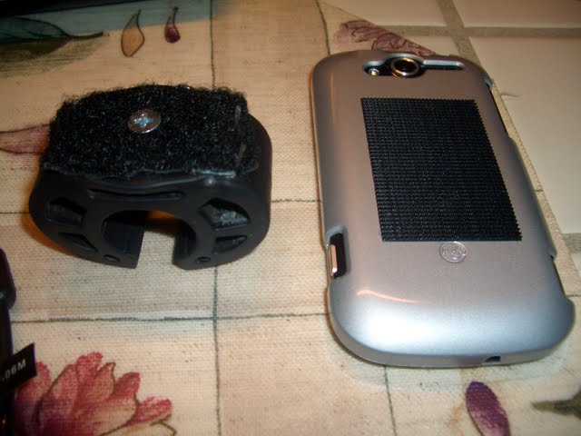
This actually makes for a very handy stand for the phone when off the bike.
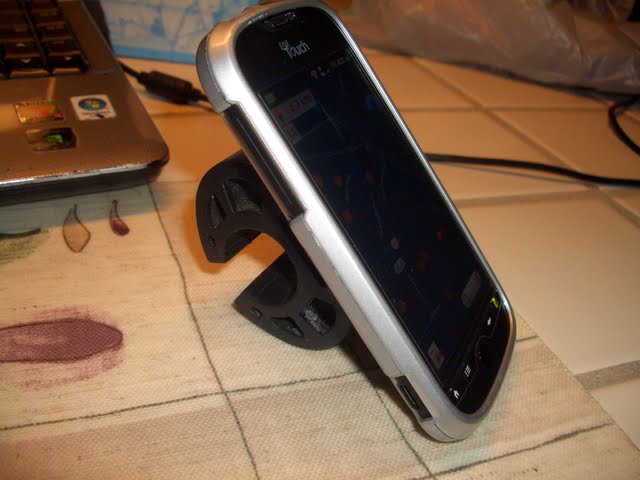
The setup is very versatile. On the bike you can easily answer calls and even use the front facing camera for video chatting. For longer rides, I use airplane mode and a dim screen for max battery life.
While some riders would rather not carry their expensive smart phone on the bike itself, I've come up with a mount that's pretty secure yet can be dismantled in seconds. Using industrial strength velcro stapled and screwed onto a watch style HRM adapter, I mate the adapter with the phone and mount to the handlebar. Saran wrap is used to waterproof as needed.
It's secure enough as is, but the earphone wire can be used to tether the phone to the bars for added bounce protection. Nevertheless, I think I'll hang on to the phone insurance.
This actually makes for a very handy stand for the phone when off the bike.
The setup is very versatile. On the bike you can easily answer calls and even use the front facing camera for video chatting. For longer rides, I use airplane mode and a dim screen for max battery life.
Last edited by sierrabob; 03-04-11 at 11:45 PM. Reason: added photo
03-11-11, 07:32 AM
#7
Senior Member
Thread Starter
Join Date: Apr 2010
Location: Atlanta, GA
Posts: 276
Bikes: 2012 Venge, 2011 Transition, Surly Troll
Mentioned: 0 Post(s)
Tagged: 0 Thread(s)
Quoted: 0 Post(s)
Likes: 0
Liked 0 Times
in
0 Posts
After multiple weeks of trying I uninstalled the app... I'm sure it's pebcak but I can't figure out what it's trying to do when I set it to "follow GPX route". It shows the route fine (point to point) and shows "me" at the beginning of the route but the directions aren't even close 1/2 the time so I can't figure out if it's just giving it's own directions and not really following the route or doing something else. Seems neat but guess I'll stick with my memorization plan for now. Wish the mapmyride app would update to follow a gpx route
03-13-11, 01:17 PM
#8
Senior Member
Join Date: Feb 2009
Posts: 210
Mentioned: 0 Post(s)
Tagged: 0 Thread(s)
Quoted: 24 Post(s)
Likes: 0
Liked 2 Times
in
2 Posts
After multiple weeks of trying I uninstalled the app... I'm sure it's pebcak but I can't figure out what it's trying to do when I set it to "follow GPX route". It shows the route fine (point to point) and shows "me" at the beginning of the route but the directions aren't even close 1/2 the time so I can't figure out if it's just giving it's own directions and not really following the route or doing something else. Seems neat but guess I'll stick with my memorization plan for now. Wish the mapmyride app would update to follow a gpx route
Here's another tip: you should always choose the "stop routing" and "clear point" options before loading a route to make sure you are going to the right place.
After a long wilderness ride with the program yesterday, I realized that the voice nav and the mapping work independently. You can have no map displayed or the wrong map displayed and still receive correct audible turn instructions based on the downloaded gpx route. If you don't use the installed map database (Vector OSM) and rely on linking to Google, you can expect some big delays in seeing a map.
The voice cues continue to work, however, regardless of the map problems. If the voice cues take you off route, then it's likely a direct to destination signal took over or you merged close to a leg that was closer to your destination. Or you may be following a previous route rather than the one you just loaded if you didn't choose stop routing/clear point beforehand.
Keep in mind also that the program needs GPS. If the signal were weakened or interrupted, you can expect some glitches.
Granted this program has problems, but I enjoy it quite a bit. Rode with it six hours yesterday and learned some more about the design features.
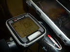
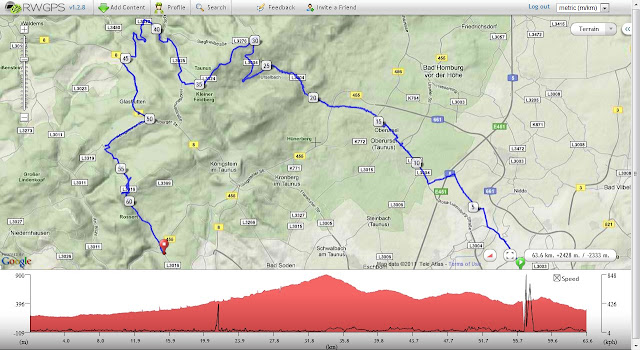
Here's a capture from part of the ride, recorded every 5 seconds by the OsmAnd app and uploaded to RidewithGPS:
Pretty cool stuff, much like the Garmin program, IMHO. If you ever reinstall, ask specific questions. I or others will try to help.
Last edited by sierrabob; 03-13-11 at 01:23 PM. Reason: clarity
03-13-11, 06:49 PM
#9
Senior Member
Join Date: Feb 2009
Posts: 210
Mentioned: 0 Post(s)
Tagged: 0 Thread(s)
Quoted: 24 Post(s)
Likes: 0
Liked 2 Times
in
2 Posts
Another OsmAnd tip: after you've heard the "trip is more than" announcement, don't push anymore buttons other than the map centering key in the upper right. If you select Directions and press the Follow key, you will dump your route and go direct to destination.
Also, the Cue Sheet available from the About Route key has no street names for a gpx route; street names are provided only if you select a point A to point B calculation using the CloudMade routing option in Settings.
Remember this program was designed primarilly to go from A to B, not to travel along a downloaded route. It just happens to be the only app that follows routes with voice nav, a huge plus that Garmin users can only dream about.
Last edited by sierrabob; 03-14-11 at 12:37 AM. Reason: clarity
03-25-11, 10:55 PM
#10
Senior Member
Join Date: Feb 2009
Posts: 210
Mentioned: 0 Post(s)
Tagged: 0 Thread(s)
Quoted: 24 Post(s)
Likes: 0
Liked 2 Times
in
2 Posts
Although this thread has not generated much interest, there are many, many people out there begging Google to come up with a GPX routing version of the voice prompt Google Navigation app. Few people realize that this OsmAnd program is potentially a killer app: it reduces battery drain and data usage by only using the GPS signal to navigate its own database with a choice of languages for voice prompts. It's perfect for following long routes over unfamiliar terrain, especially in foreign countries where data roaming is cost prohibitive.
03-26-11, 07:11 AM
#11
Senior Member
Join Date: Mar 2011
Posts: 1,029
Mentioned: 1 Post(s)
Tagged: 0 Thread(s)
Quoted: 7 Post(s)
Likes: 0
Liked 1 Time
in
1 Post
Why not use runkeeper?
I've got installed on my device and it's great! It keeps my pace/route/avg pace/speed and logs how many km I've did on my bike.
Check one of my routes: https://runkeeper.com/user/8bits/activity/29043889
I've got installed on my device and it's great! It keeps my pace/route/avg pace/speed and logs how many km I've did on my bike.
Check one of my routes: https://runkeeper.com/user/8bits/activity/29043889
03-26-11, 10:38 AM
#12
Senior Member
Join Date: Feb 2009
Posts: 210
Mentioned: 0 Post(s)
Tagged: 0 Thread(s)
Quoted: 24 Post(s)
Likes: 0
Liked 2 Times
in
2 Posts
Why not use runkeeper?
I've got installed on my device and it's great! It keeps my pace/route/avg pace/speed and logs how many km I've did on my bike.
Check one of my routes: https://runkeeper.com/user/8bits/activity/29043889
I've got installed on my device and it's great! It keeps my pace/route/avg pace/speed and logs how many km I've did on my bike.
Check one of my routes: https://runkeeper.com/user/8bits/activity/29043889
04-06-11, 11:36 PM
#13
Senior Member
Join Date: Feb 2008
Location: London
Posts: 740
Bikes: Mezzo D9, 2012 Giant Avail 2
Mentioned: 0 Post(s)
Tagged: 0 Thread(s)
Quoted: 13 Post(s)
Likes: 0
Liked 0 Times
in
0 Posts
Google took me here, and it may be that OsmAnd is just what I am looking for.
I want to plot out this route when I am roaming: https://www.cycling-loire.com/tabid/2...20%2F%20Tours#
I couldn't see how to extract the gpx, so I hand traced it on gmap pedometer https://www.gmap-pedometer.com/?r=4401500 and put a gpx file on my phone. I can now see the route in OsmAnd. I've downloaded data for that area and UK, but when I put my phone in airline mode, I can't see any maps. What am I doing wrong?
thanks
joan
ps the tracing doesn't seem to be brilliant, but I can live with that.
04-07-11, 07:39 AM
#14
Senior Member

Join Date: Nov 2010
Location: North of Mayo Clinic Minnesota
Posts: 507
Bikes: Trek 820 Madone 6.2. Trek 2.1
Mentioned: 0 Post(s)
Tagged: 0 Thread(s)
Quoted: 0 Post(s)
Likes: 0
Liked 0 Times
in
0 Posts
Go to Market and download AllsportGPS. You can make your own routes on the web and they will import to your phone and you can follow that route. Any route you ride it will upload to the web page for future use. Keeps track of your mph elevation and many other stats. There is now a Free version and a $9.99 one.
04-07-11, 01:11 PM
#15
Senior Member
Join Date: Feb 2009
Posts: 210
Mentioned: 0 Post(s)
Tagged: 0 Thread(s)
Quoted: 24 Post(s)
Likes: 0
Liked 2 Times
in
2 Posts
Google took me here, and it may be that OsmAnd is just what I am looking for.
I want to plot out this route when I am roaming: https://www.cycling-loire.com/tabid/2...20%2F%20Tours#
I couldn't see how to extract the gpx, so I hand traced it on gmap pedometer https://www.gmap-pedometer.com/?r=4401500 and put a gpx file on my phone. I can now see the route in OsmAnd. I've downloaded data for that area and UK, but when I put my phone in airline mode, I can't see any maps. What am I doing wrong?
thanks
joan
ps the tracing doesn't seem to be brilliant, but I can live with that.
I want to plot out this route when I am roaming: https://www.cycling-loire.com/tabid/2...20%2F%20Tours#
I couldn't see how to extract the gpx, so I hand traced it on gmap pedometer https://www.gmap-pedometer.com/?r=4401500 and put a gpx file on my phone. I can now see the route in OsmAnd. I've downloaded data for that area and UK, but when I put my phone in airline mode, I can't see any maps. What am I doing wrong?
thanks
joan
ps the tracing doesn't seem to be brilliant, but I can live with that.
Also, you need to ensure you have downloaded the correct maps for your area. This may require creating your own maps using the OsmAndMapCreator program. Let me know if you need any help with that.
Note that in Airplane mode all radios except GPS should be off with an Android phone, although with some handsets you may need to turn it on manually.
Finally, although other apps mentioned in this thread perform navigation and record performance, none offer free turn by turn voice instructions of downloaded maps following gpx routes. Only OsmAnd offers this function, a real value for cycling explorers, tourists, or just folks trying to follow a club ride without needing a cue sheet.
04-07-11, 11:30 PM
#17
Senior Member
Join Date: Feb 2008
Location: London
Posts: 740
Bikes: Mezzo D9, 2012 Giant Avail 2
Mentioned: 0 Post(s)
Tagged: 0 Thread(s)
Quoted: 13 Post(s)
Likes: 0
Liked 0 Times
in
0 Posts
Thanks. That was the trick. Oh, the airplane mode was just a quick way of turning the internet off, I don't use it abroad generally.
The voice controls seem a bit crap. I was using it follow a path back and it kept directing me right when the next turn was left and telling me over and over "drive for more than ...5 kilometres" I'll try it again to see if I can use it.
AllSportGPS also seems a bit weird. I uploaded two routes to the website, but only one appeared on my phone, despite multiple refreshes. I couldn't find any instructions on how to use it, to follow a route, so I clicked the "follow" button and it crashed. It's also hard to use on my phone that has a smaller screen - text is disappearing under the weather ... and why is the weather there anyway?
thanks guys. Will be back with more questions later.
04-08-11, 05:51 AM
#18
Senior Member
Join Date: Feb 2009
Posts: 210
Mentioned: 0 Post(s)
Tagged: 0 Thread(s)
Quoted: 24 Post(s)
Likes: 0
Liked 2 Times
in
2 Posts
Proper how-to instructions for anything Android in nature seems lacking, even with many Google apps. You will have to use these programs over and over to figure them out, especially the OsmAnd app. If you're following a gpx route, for example, you can't use the "directions" button again. This will perform a route recalculation and take you direct to your destination, disregarding the gpx route. Also, GPS signal interruption can cause bogus turn instructions. When the program does not give you advance warning of a turn (e.g., "in 150 meters, turn left") and just commands a turn, it's picked up a spurious signal that should be disregarded.
BTW, I can't imagine any road longer than 5km in London other than motorways. Are you not using the bicycle setting?
BTW, I can't imagine any road longer than 5km in London other than motorways. Are you not using the bicycle setting?
04-08-11, 08:11 PM
#19
Senior Member
Join Date: Apr 2007
Location: Newfield, NY
Posts: 140
Mentioned: 0 Post(s)
Tagged: 0 Thread(s)
Quoted: 0 Post(s)
Likes: 0
Liked 0 Times
in
0 Posts
I use a mapping program called Orux and really like it. It doesn't do voice prompts, though. It does allow you to import gpx routes and has an alarm feature if you stray. It has a few map servers that it links to for maps. One of them does a nice job of ovelaying the road info over topo maps and includes bike routes. You can download maps for offline use. You can also download topo maps on your own from usgs and calibrate and install them using a desktop ap that orux has for free. I also use this ap for making nautical charts. So it doesn't have exactly what you want but is pretty intuitive to use and has good support.
04-09-11, 04:25 AM
#20
Senior Member
Join Date: Feb 2008
Location: London
Posts: 740
Bikes: Mezzo D9, 2012 Giant Avail 2
Mentioned: 0 Post(s)
Tagged: 0 Thread(s)
Quoted: 13 Post(s)
Likes: 0
Liked 0 Times
in
0 Posts
Thanks sesmith, I'll check Orux out, too.
My requirements are quite simple, I'd be happy enough with google "My maps" except the painful process from GPX->Google Earth->KML->MyMaps, and the fact that it kept truncating the route. Of line maps, voice commands etc are just a bonus.
sierrabob: I'm definitely in bike mode. I've tried tracing a route via pedometer and recording it and then returning. In each case I just load the gpx file and don't do anything else. Where is the "directions" button? I'll keep using it on my commute, and hopefully get used to the foibles. At the moment, she does things like saying "in 150m turn right" when the next turn is left. And then at the corner, saying "turn left now" which is the opposite of your experience.
Minimum required: just something to show me where I am and when I should turn and when I have missed the turn. I don't really want to carry a map for following a bike path/road for 20km+ journey. No real danger of getting lost, as we are following a river through the heart of France
04-09-11, 07:39 AM
#21
Senior Member
Join Date: Feb 2009
Posts: 210
Mentioned: 0 Post(s)
Tagged: 0 Thread(s)
Quoted: 24 Post(s)
Likes: 0
Liked 2 Times
in
2 Posts
Thanks sesmith, I'll check Orux out, too.
My requirements are quite simple, I'd be happy enough with google "My maps" except the painful process from GPX->Google Earth->KML->MyMaps, and the fact that it kept truncating the route. Of line maps, voice commands etc are just a bonus.
sierrabob: I'm definitely in bike mode. I've tried tracing a route via pedometer and recording it and then returning. In each case I just load the gpx file and don't do anything else. Where is the "directions" button? I'll keep using it on my commute, and hopefully get used to the foibles. At the moment, she does things like saying "in 150m turn right" when the next turn is left. And then at the corner, saying "turn left now" which is the opposite of your experience.
Minimum required: just something to show me where I am and when I should turn and when I have missed the turn. I don't really want to carry a map for following a bike path/road for 20km+ journey. No real danger of getting lost, as we are following a river through the heart of France
My requirements are quite simple, I'd be happy enough with google "My maps" except the painful process from GPX->Google Earth->KML->MyMaps, and the fact that it kept truncating the route. Of line maps, voice commands etc are just a bonus.
sierrabob: I'm definitely in bike mode. I've tried tracing a route via pedometer and recording it and then returning. In each case I just load the gpx file and don't do anything else. Where is the "directions" button? I'll keep using it on my commute, and hopefully get used to the foibles. At the moment, she does things like saying "in 150m turn right" when the next turn is left. And then at the corner, saying "turn left now" which is the opposite of your experience.
Minimum required: just something to show me where I am and when I should turn and when I have missed the turn. I don't really want to carry a map for following a bike path/road for 20km+ journey. No real danger of getting lost, as we are following a river through the heart of France
Not sure if you have the phone mounted on your stem or handlebars to view the map display, but you'll need that for your little trip and to troubleshoot your nav issues. With the OsmAnd app, press the menu key to bring up the directions button, or the "more" soft key. Keep playing with it or just disregard for your river journey. It's better suited for long rides with lots of turns in unfamiliar territory.
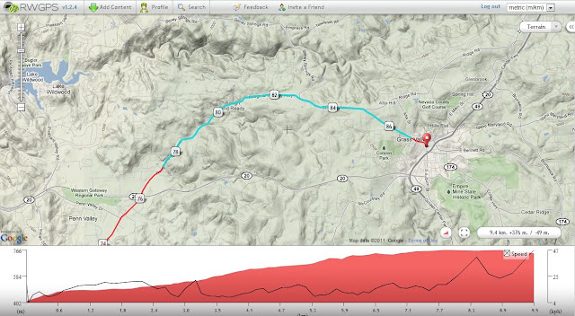
Here's an image of a ride I did northwest of Frankfurt recently. Using RidewithGPS, I searched for routes posted near Frankfurt, downloaded as a GPX route to my OsmAnd app, then rode it on March 29. Never would have been able to find my way through all the little turns without this OsmAnd app. While other apps come close, e.g., BikeRoute and MyTracks, none allow me to do this:
Last edited by sierrabob; 04-09-11 at 07:52 AM. Reason: clarity
04-16-11, 11:38 AM
#22
Senior Member
Join Date: Feb 2008
Location: London
Posts: 740
Bikes: Mezzo D9, 2012 Giant Avail 2
Mentioned: 0 Post(s)
Tagged: 0 Thread(s)
Quoted: 13 Post(s)
Likes: 0
Liked 0 Times
in
0 Posts
Thanks again for the help.
1) Google maps - I meant minimum requirement - be able to see a map with the route marked on it. You can create "my maps" via google maps page, and then view them with maps on the android phone. Only thing is they always get truncated when I try to do that.
2) Yup, phone on the handlebars. Using a Krusell and very happy with it.
3) She is definitely a bit eccentric. I've put in my commute using the same method, and the first day I tried to follow it she was telling me a left was coming up when it was a right turn, and then for "2.4 km" she was telling me I was going to have to turn around and go back "In 2.4km, turn around and go back". The next time I followed the same route, she reported it correctly.
4) Obviously I'm relaxed about the trip. It's a nice pootle through french country-side, and I can't really get lost, even if I lost the phone.
So thanks, I think it's going to be fine.
joan
04-17-11, 04:15 AM
#23
Senior Member
Join Date: Feb 2009
Posts: 210
Mentioned: 0 Post(s)
Tagged: 0 Thread(s)
Quoted: 24 Post(s)
Likes: 0
Liked 2 Times
in
2 Posts
BTW, I believe the voice you have installed is actually that of Vicki Archer, a UK radio DJ. There is a nice male French voice of very good quality available in the Osmand data base. Also, if you download OsmAnd Voice, you can install many different voices. Here's a link to some voice choices. https://www.gps-data-team.com/pda-gps...inks/index.php As a non-Britisher, I can barely understand the Chav female voice, but it's quite entertaining.
Last edited by sierrabob; 04-17-11 at 04:38 AM. Reason: spelling
05-08-11, 11:49 AM
#24
Senior Member
Join Date: Feb 2008
Location: London
Posts: 740
Bikes: Mezzo D9, 2012 Giant Avail 2
Mentioned: 0 Post(s)
Tagged: 0 Thread(s)
Quoted: 13 Post(s)
Likes: 0
Liked 0 Times
in
0 Posts
Thanks again.
Trip ended up quite differently from originally planned (we didn't do the cycle route above AND I had the wrong location for the hotel).
However, it was very useful for navigating across paris in peak hour, though I still didn't use the voice, just watched the map unfold.
Trip ended up quite differently from originally planned (we didn't do the cycle route above AND I had the wrong location for the hotel).
However, it was very useful for navigating across paris in peak hour, though I still didn't use the voice, just watched the map unfold.
10-10-12, 05:16 PM
#25
Junior Member
Join Date: Oct 2012
Posts: 5
Mentioned: 0 Post(s)
Tagged: 0 Thread(s)
Quoted: 0 Post(s)
Likes: 0
Liked 0 Times
in
0 Posts
Found this thread with google search. I have been searching for an app to follow custom routes on my android phone for months and found nothing. After reading this thread, I downloaded Osmand and started trying to make it follow a .gpx file. Unfortunately, I am having no luck. I started in Google maps making a very simple route from work to home. I threw in two minor deviations from the route google wants to go just to make it "custom". I then converted that to a gpx and saved it to the tracks folder under Osmand on my phone. I have downloaded the maps for my state (North Carolina). I opened Osmand, selected directions, chose car, then GPX route. The route shows up, so I select that. Next I have to choose Reverse GPX direction, Use current destination, or Pass along entire track. The only choice that makes sense is Pass along entire track, so did that. It then says "the trip is 16 Km". The route is displayed on the map, so I start driving.
The first thing I notice is that the route is shown as straight lines form point to point. It doesn't actually follow the curves of the road. When the road is straight, it appears to be working, but as soon as the road curves, it gets confused and starts recalculating the route, telling me to make U turns, etc.
Below is a screen shot. You can see the blue route line is perfectly straight and not following any actualy road. The route programmed was supposed to follow Zion Church Road, which is where the red arrow is pointing.

It would be fantastic if this app would work. For now, I just have to make my google maps, then set my phone to track my location. I can see if I deviate from the blue route line, but it isn't great. I really would like to have voice instructions, plus the offline capability. If anyone can help figure this out, I would be most appreciative. Thanks.
The first thing I notice is that the route is shown as straight lines form point to point. It doesn't actually follow the curves of the road. When the road is straight, it appears to be working, but as soon as the road curves, it gets confused and starts recalculating the route, telling me to make U turns, etc.
Below is a screen shot. You can see the blue route line is perfectly straight and not following any actualy road. The route programmed was supposed to follow Zion Church Road, which is where the red arrow is pointing.
It would be fantastic if this app would work. For now, I just have to make my google maps, then set my phone to track my location. I can see if I deviate from the blue route line, but it isn't great. I really would like to have voice instructions, plus the offline capability. If anyone can help figure this out, I would be most appreciative. Thanks.