


How to find an empty MUP
 05-09-08, 04:10 PM
#1
Senior Member
Thread Starter
Join Date: Dec 2002
Location: Cherry Hill,NJ
Posts: 1,176
Mentioned: 0 Post(s)
Tagged: 0 Thread(s)
Quoted: 2 Post(s)
Liked 0 Times
in
0 Posts
How to find an empty MUP
As part of my new "Nothing stops a scheduled training ride" policy I rode on an empty MUP today. No people! No "On your left!!!!" It was great! Well except for the stinging rain, 25 mph winds with higher gusts and 50 degree temps. Other than that it was perfect!
Actually it was very good!
Don't let the weather stop your next ride.
Actually it was very good!
Don't let the weather stop your next ride.


 05-09-08, 04:19 PM
#3

Approaching Nirvana

Join Date: Aug 2003
Location: Tomah, WI
Posts: 1,223
Bikes: Catrike Expedition
Mentioned: 0 Post(s)
Tagged: 0 Thread(s)
Quoted: 0 Post(s)
Likes: 0
Liked 0 Times
in
0 Posts
 05-09-08, 08:02 PM
#6
Cycle Year Round

A small portion of my commute is on the Pearl Harbor Bike Path. No matter how bad the weather, I am never the only one on the path. I can count on seeing a women with a cane and leg supports, who has had a couple of strokes, walking on the path for her twice a day exercise.
05-09-08, 08:18 PM
#7
Senior Member
Thread Starter
Join Date: Dec 2002
Location: Cherry Hill,NJ
Posts: 1,176
Mentioned: 0 Post(s)
Tagged: 0 Thread(s)
Quoted: 2 Post(s)
Liked 0 Times
in
0 Posts
DF, I'm jealous! OK,maybe just green with envy. I'd love to come there for a visit. Looks like a beautiful place.
05-09-08, 09:29 PM
#8
Banned.

Join Date: Aug 2001
Posts: 20,917
Mentioned: 0 Post(s)
Tagged: 0 Thread(s)
Quoted: 0 Post(s)
Likes: 0
Liked 12 Times
in
10 Posts
A small portion of my commute is on the Pearl Harbor Bike Path. No matter how bad the weather, I am never the only one on the path. I can count on seeing a women with a cane and leg supports, who has had a couple of strokes, walking on the path for her twice a day exercise.
We also have a tiny little lady, about 85, who walks with her cane (she had a hip replacement) for miles and miles. I see her all over the place, and frequently talk with her. I've seen her 3 - 4 miles from her home. She walks about 2.5 miles per hour.
05-09-08, 09:39 PM
#10
Surly Girly

Join Date: Mar 2007
Location: SoCal
Posts: 4,116
Mentioned: 0 Post(s)
Tagged: 0 Thread(s)
Quoted: 2 Post(s)
Likes: 0
Liked 0 Times
in
0 Posts
05-09-08, 10:08 PM
#11
www.ocrebels.com
Join Date: Aug 2006
Location: Los Angeles area
Posts: 6,186
Bikes: Several bikes, Road, Mountain, Commute, etc.
Mentioned: 1 Post(s)
Tagged: 0 Thread(s)
Quoted: 83 Post(s)
Likes: 0
Liked 5 Times
in
2 Posts
The Coyote Creek MUP is pretty much empty most of the time. An occasional walker, runner or cyclist, but not many, for sure. And that's even on a nice day!
Rick / OCRR
Rick / OCRR
05-10-08, 12:18 AM
#12
Time for a change.

Join Date: Jan 2004
Location: 6 miles inland from the coast of Sussex, in the South East of England
Posts: 19,913
Bikes: Dale MT2000. Bianchi FS920 Kona Explosif. Giant TCR C. Boreas Ignis. Pinarello Fp Uno.
Mentioned: 2 Post(s)
Tagged: 0 Thread(s)
Quoted: 3 Post(s)
Likes: 0
Liked 5 Times
in
4 Posts
The mups connect communities and towns and in the "Over" crowded South East of the UK- there are too many commuters using them and far too many dogs that will drag their owners out in all weathers.
__________________
How long was I in the army? Five foot seven.
Spike Milligan
How long was I in the army? Five foot seven.
Spike Milligan
05-10-08, 04:43 AM
#13
gone ride'n
Join Date: Aug 2007
Location: Upstate NY
Posts: 4,050
Bikes: Simoncini, Gary Fisher, Specialized Tarmac
Mentioned: 0 Post(s)
Tagged: 0 Thread(s)
Quoted: 0 Post(s)
Likes: 0
Liked 1 Time
in
1 Post
Here are some pictures of the Mohawk Hudson MUP - where you will usually find me riding

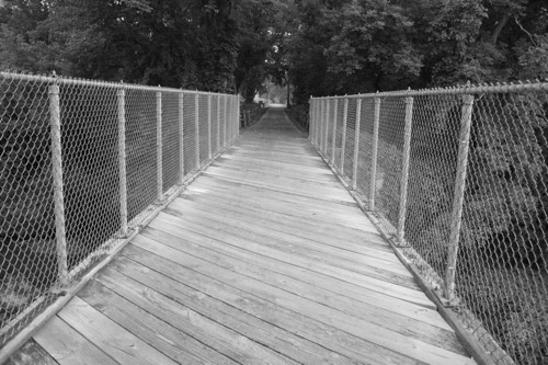
This bike trail follows the original route of one of the first rail lines in the US - along the Mohawk river and is almost continuous from the Hudson to Amsterdam and is continually being filled in all the way to Buffalo. Every few miles you pass a lock for the canal - here is lock 7 a few miles from my house
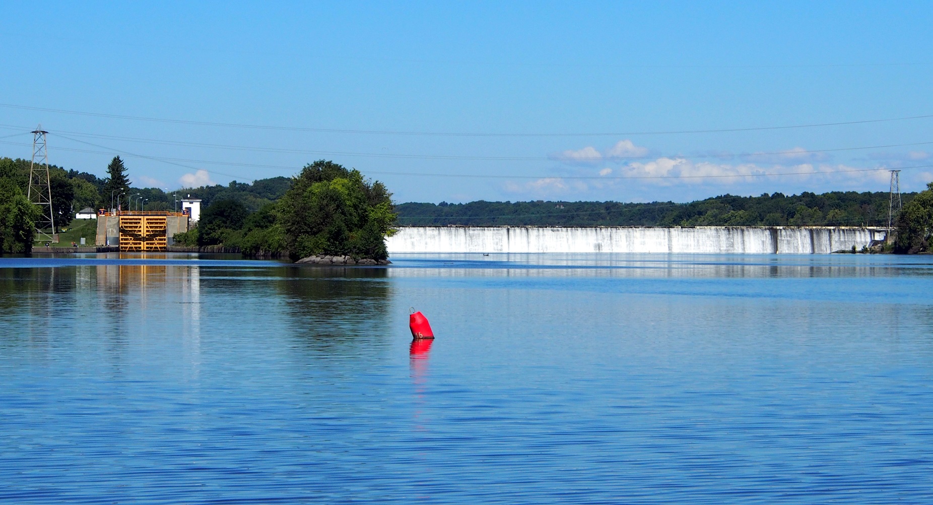
This bike trail follows the original route of one of the first rail lines in the US - along the Mohawk river and is almost continuous from the Hudson to Amsterdam and is continually being filled in all the way to Buffalo. Every few miles you pass a lock for the canal - here is lock 7 a few miles from my house
05-10-08, 06:04 AM
#14
Banned.
Join Date: Aug 2001
Posts: 20,917
Mentioned: 0 Post(s)
Tagged: 0 Thread(s)
Quoted: 0 Post(s)
Likes: 0
Liked 12 Times
in
10 Posts
It looks like NY has a really neat canal trail system:
https://www.nyscanals.gov/exvac/trail/index.html
New York State Canalway Trail System
Here is an interactive map:
https://www.nyscanals.gov/maps/index.html
The New York State Canalway Trail System is comprised of a network of more than 260 miles of existing multi-use, recreational trails across upstate New York. Major segments are adjacent to the waterways of the New York State Canal System (see our map) or follow remnants of the historic original canals of the early 1800s that preceded today's working Canal System.
The Canalway Trail System is comprised of four major segments: the 100-mile Erie Canal Heritage Trail in Western New York; the 36-mile Old Erie Canal State Park Trail in Central New York; the 60-mile Mohawk-Hudson Bikeway in the eastern Capital Region, and the eight-mile Glens Falls Feeder Canal Trail in the foothills of the Adirondacks near Lake George. In addition, there are smaller segments of Canalway Trail.
These trail segments and other areas of the Canalway Trail System connect with trails leading throughout New York State, providing one of the most extensive trail networks in the country.
Canalway Trail Times
Find out what’s going on along the Canalway Trail in the Canalway Trail Times newsletter. The publication contains information on volunteer programs, trail development updates and events from across the corridor. To view the latest edition, please refer to the Parks and Trails New York website.
FOLLOW THE TRAILBLAZERS TO THE CANALWAY TRAIL The major segments of the Canalway Trail are easy to find by following the distinctive trailblazers installed along New York State and local routes.
Purchase the official Canalway Trail Cycling Guide.
Erie Canal Heritage Trail -* a 100-mile Trail between Tonawanda and Newark in Western New York. This Trail segment is designated as a National Recreation Trail and has numerous access points, primarily where local roads intersect. Parking is available at many of the access points. Sign kiosks containing maps and historic information are located at many trailheads. Trail Uses: Hiking, bicycling, cross-country skiing (all sections); horseback riding and snowmobiling in some sections (for details call the Canal Corporation). Trail Surface: Stone dust; some portions in Tonawanda and Rochester are asphalt. Biker-Hiker-Boater Campsites are located at Lock 30 in Macedon and at the Holley Canal Port.
Trail Uses: Hiking, bicycling, cross-country skiing.
Trail Surface: Stone dust, gravel.
Old Erie Canal State Park Trail - a 36-mile Trail within the linear State Park between DeWitt and Rome in Central New York. Designated as a National Recreation Trail, this segment incorporates an abandoned section of the nineteenth century-era Erie Canal. Parking areas with foot-bridge access to the Trail are located at Poolsbrook and Cedar Bay picnic areas within the park.
Trail Uses: Hiking, bicycling, cross-country skiing, horseback riding and snowmobiling. Trail Surface: Stone dust, gravel.
Mohawk-Hudson Bikeway - a 60-mile Trail along the Erie Canal and Mohawk River between St. Johnsville and Waterford in the Capital Region. Many sections of this segment were built on former grades of the nineteenth century Erie Canal towpath. The trail is continuous except for a segment between Rotterdam Junction and Amsterdam, a short segment under Interstate Route 87 (Adirondack Northway) in the Town of Colonie, and short segments in Schenectady and Cohoes. The bikeway route is signed along connecting roadways.*
Trail Uses: Hiking, bicycling, in-line skating and cross-country skiing. Motorized vehicles are not allowed.*
Trail Surface: Stone dust in Montgomery County and on a one-mile segment in Cohoes. Asphalt elsewhere.
Glens Falls Feeder Canal Trail - an eight-mile Trail between Glens Falls and Fort Edward along the historic Feeder Canal near the Hudson River and Old Champlain Canal. The Trail follows the towpath along the Feeder Canal, which is one of the last surviving sections of the original 1820s Canal System. The Feeder Canal was built in the late 1820s to help maintain the water level in the Champlain Canal, since the section between Fort Ann and Fort Edward was higher than the rest of the Canal. A link between the Feeder Canal Trail and the Warren County/Bikeway leading to Lake George is signed along connecting roadways in Glens Falls.*
Trail Uses: Hiking, bicycling, cross-country skiing. Motorized vehicles are not allowed. Trail Surface: Stone dust.
WATCH THE CANALWAY TRAIL SYSTEM GROW
The New York State Canal Corporation's long-range goal for the Canalway Trail System is to create a cross-State network of multi-use trails that will span nearly 500 miles across upstate New York, paralleling major portions of the 524-mile New York State Canal System.
When completed over the next several years, the Trail System will provide a means for those who are not boaters to enjoy the beauty and the history found all along New York's Canals. The System will include both urban and rural trails to meet the needs of both visitors and local residents alike.
Completion of the Trail will involve the creation of partnerships between the New York State Canal Corporation and a variety of organizations, including local governments, not-for-profit organizations, other New York State government agencies, and the National Park Service.
FIND THE CANALWAY TRAIL TODAY
A free map of the New York State Canalway Trail System is available from the New York State Canal Corporation. To obtain a copy, or to learn more about the Canalway Trail, call: Toll-free (800)-4CANAL4 or write: New York State Canal Corporation P.O. Box 189 Albany, NY 12201-0189.
Last edited by DnvrFox; 05-10-08 at 06:13 AM.
05-10-08, 04:28 PM
#15
His Brain is Gone!

Join Date: Sep 2006
Location: Paoli, Wisconsin
Posts: 9,979
Bikes: RANS Stratus, Bridgestone CB-1, Trek 7600, Sun EZ-Rider AX, Fuji Absolute 1.0, Cayne Rambler 3
Mentioned: 1 Post(s)
Tagged: 0 Thread(s)
Quoted: 2 Post(s)
Likes: 0
Liked 1 Time
in
1 Post
I had time to get out for a short 10 mile ride on a rail trail today. In the first mile I saw 4 people (2 walking, 2 riding). That's a lot in these parts. But then over the next 9 miles I saw only 5 more, so that comes out to seeing only 1 person per mile. It was overcast, temps in the high 50s, mild breeze. Nice day for riding.
__________________
"Too often I would hear men boast of the miles covered that day, rarely of what they had seen." Louis L'Amour
There are two types of road bikers: bikers who are faster than me, and me. Bruce Cameron - Denver Post
"Too often I would hear men boast of the miles covered that day, rarely of what they had seen." Louis L'Amour
There are two types of road bikers: bikers who are faster than me, and me. Bruce Cameron - Denver Post
05-10-08, 04:43 PM
#16
Senior Member
Join Date: Sep 2007
Location: Denver, Co.
Posts: 699
Mentioned: 0 Post(s)
Tagged: 0 Thread(s)
Quoted: 1 Post(s)
Likes: 0
Liked 0 Times
in
0 Posts
OK I'll bite, where is that?
I did my 19 mi yesterday,, home to Cherry crk. to confluence. Platte to dartmouth, to home..
Bud
I did my 19 mi yesterday,, home to Cherry crk. to confluence. Platte to dartmouth, to home..
Bud
05-10-08, 04:50 PM
#17
gone ride'n
Join Date: Aug 2007
Location: Upstate NY
Posts: 4,050
Bikes: Simoncini, Gary Fisher, Specialized Tarmac
Mentioned: 0 Post(s)
Tagged: 0 Thread(s)
Quoted: 0 Post(s)
Likes: 0
Liked 1 Time
in
1 Post
DNVR - How dare you!! You let the whole secret out. Next thing you'll tell us is you are moving to Up State NY
Well - we would welcome you.
NY has a lot of problems - but we have a lot of really great stuff too.
I will need to post pictures if TSL and I do the Idaride in the Adirondacks in Aug - the spectacular beauty will just take your breath away.
Well - we would welcome you.
NY has a lot of problems - but we have a lot of really great stuff too.
I will need to post pictures if TSL and I do the Idaride in the Adirondacks in Aug - the spectacular beauty will just take your breath away.
05-10-08, 04:54 PM
#18
Banned.
Join Date: Aug 2001
Posts: 20,917
Mentioned: 0 Post(s)
Tagged: 0 Thread(s)
Quoted: 0 Post(s)
Likes: 0
Liked 12 Times
in
10 Posts
If I go from Cottonwood to Franktown - the trail goes though now, even if it doesn't show on the map - (and on to Castlewood Canyon State Park - which is a road fior 5 miles, but hardly ever used) and then return and include the Sulphur Gulch and the Tallman Gulch trails, I will have gone about 62 miles.
Also, a bunch of us rode from Englewood Golf Course to Confluence Park and back Tuesday - 20 miles.
05-12-08, 10:20 AM
#19
Senior Member
Join Date: Sep 2007
Location: Denver, Co.
Posts: 699
Mentioned: 0 Post(s)
Tagged: 0 Thread(s)
Quoted: 1 Post(s)
Likes: 0
Liked 0 Times
in
0 Posts
Any weekday on the Parker Cherry Creek, Sulphur Gulch trails (far south).
If I go from Cottonwood to Franktown - the trail goes though now, even if it doesn't show on the map - (and on to Castlewood Canyon State Park - which is a road fior 5 miles, but hardly ever used) and then return and include the Sulphur Gulch and the Tallman Gulch trails, I will have gone about 62 miles.
Also, a bunch of us rode from Englewood Golf Course to Confluence Park and back Tuesday - 20 miles.
Off now to downtown via wash park and c/c trail to play 3 cushion..
and back via platte south...The spring rides have dropped my b/p 25 points, so gotta keep it up...
Bud
05-12-08, 09:33 PM
#20
Plays in traffic

Join Date: May 2006
Location: Rochester, NY
Posts: 6,971
Bikes: 1996 Litespeed Classic, 2006 Trek Portland, 2013 Ribble Winter/Audax, 2016 Giant Talon 4
Mentioned: 21 Post(s)
Tagged: 0 Thread(s)
Quoted: 76 Post(s)
Likes: 0
Liked 14 Times
in
9 Posts
On the topic of the Canalway, around here, it's jam packed all weekend and most evenings. Wobble speed is the usual max. At my usual commute times, (lunch and evening) it's filled with joggers, usually with iPods.
Traffic is thin on my Saturday 7:15 AM commute--mostly other cyclists, and mostly moving along. After subbing for a co-worker this evening, it was empty after dark. Nicest ride I've had on it since the weather got nice. I'll have to ride it after dark more often.
05-13-08, 07:21 AM
#21
Senior Member
Join Date: Oct 2007
Location: Medina, OH
Posts: 5,804
Bikes: confidential infromation that I don't even share with my wife
Mentioned: 5 Post(s)
Tagged: 0 Thread(s)
Quoted: 35 Post(s)
Likes: 0
Liked 1 Time
in
1 Post
This trail is near our family's cabin in Western PA. Since it does not connect two busy cities it is not busy at all. With the Allegheny River on one side and woods and tree canopy over head this place is special. You need a light as there are also several tunnels to go thru. The Sandy Creek portion of the trail goes up thru a valley with many bridges providing plenty of places to stop and enjoy nature.
https://www.avta-trails.org/allegheny-samuel-trails.html
https://www.avta-trails.org/allegheny-samuel-trails.html
