


Indian Valley Century-Report w/ pics
 05-25-09, 12:11 AM
#1

Lincoln, CA
Thread Starter
Join Date: Sep 2004
Location: Lincoln, CA
Posts: 2,229
Bikes: 94 Giant ATX 760, 2001 Biachi Eros, 2005 Giant OCR2 Composite +
Mentioned: 0 Post(s)
Tagged: 0 Thread(s)
Quoted: 1 Post(s)
Likes: 0
Liked 2 Times
in
1 Post
Indian Valley Century-Report w/ pics
Well, this hardly seems worth the post after reading RickOCRR's wonderful account of the Davis Double, but I have pictures.
Saturday, I rode in the Indian Valley (Greenville, Plumas County, CA) Century for the 6th consecutive year. It was the first century I ever did and happens to fall exactly one week before I leave on the AIDS/LifeCycle 7-day ride from San Francisco to Los Angeles. It has become a tradition to make it my last real ride before the AIDS ride.
I left Friday at noon to make the 2 1/2 hour drive to Quincy, my former home of 36 years. I made the rounds visiting old friends and colleagues before heading to Pete'n'Julie's for the night, preceded by a wonderful dinner of BBQed Tri-Tip and red wine on the deck.
Pete, Julie and I left at 6:15am for the 7:00 start in Greenville, a half hour away. We had hoped to meet up with other members of the Plumas-Sierra Bicycle Club and wore our colors proudly. We didn't see anyone else until we were on the road.
It was a bit nippy, low 40s. Arm warmers and a wind breaker for me. This is one of the most beautiful rides in the state, I'm sure. The first 35 miles are pretty flat, with just a couple of rollers+. The road follows the edge of the valley, so one side is a big meadow and the other a steep, wooded hill. I was feeling pretty good and having no trouble maintaining 17-18 mph in our little group of 4. As always, there were cattle, wild turkeys, snakes (dead) an hawks everywhere.
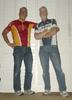
We had pre-decided to keep rest-stop time at a minimum. At mile 15 I refilled my water and Gatorade bottles (mixing my berry with their lemon), grabbed some Oreos, banana and a "Little Debbie" packaged coffee cake. We met another friend and our group of 5 took off. Here's a picture to help you visualize.

This leg has the rollers, but I was still averaging 16 mph when we pulled in the town of Genesee, the second rest stop and lunch stop on the way back. Genesee consists of a store and two houses. This is it.

Even though it was only about 9:45, lunch was coming out. More Oreos and a banana, but I grabbed a couple pieces of cheese and sliced turkey. I shed the arms and windbreaker.
The other three riders turned around here, as they had signed up for the metric century. Now, I know I am about to start riding alone. Pete is a certified animal and the one major climb of the ride is upon us. The first two miles of the climb is VERY steep, I estimate 12% or more, with a couple of switchbacks that are worse. As anticipated, Pete is soon out of sight. I am proud to say however, that I did not use my two granniest gears at any time. Hill climbing is not my forte, but I'm doing OK. Those d&#m kids in kits pass me like I'm on a break, but I actually caught a couple of riders. Oh, did I mention that after that first 2 miles THERE ARE NINE MORE MILES OF MOSTLY CLIMBING?! It's 1600 feet of elevation gain and at least 30,000 feet of climbing, I'm sure.
Now, here's the freaky part: I caught Pete!!! In the spirit of full disclosure however, I must say that the only reason I caught him was his flat tire. We rode together for a while, until a bike club member came by and they were both off and soon out of sight. Here's a picture of the creek that parallels the road.

Antelope Lake and the top of the climb is at 45 miles. It is a lovely Alpine lake, it's beauty marred by three forest fires in the last 12 years. This is what it looks like now, on the west and north side.

I meet Pete at the 47-mile rest stop and we start the remaining 9 miles of the ride around the lake. The road on the climb is not very good, but around the lake it's quite smooth. I think that, and the brief rest stop (and a PB&J) perked me up a bit. I was almost keeping up with Pete on the rollers, but my legs were protesting. But I know that it's mostly downhill or flat from here, so I'm hangin' on.
What were nice respites coming up the hill became pesky climbs on the way "down". As mentioned, the road is not great, marred by perpendicular cracks that can make your handlebars come loose and sandy turns. There are also riders still coming UP the hill and the occasional pickup truck on it's way to a camping spot. Plus it had gotten windy. I have to admit, I didn't have much confidence going down and remained cautious, albeit I apparently hit 40.2 mph somewhere along the way.
Now, back at what was rest stop #2, this time for lunch. And I would sit down for the first time today. Lunch was great. I made a chicken-black bean and corn salsa - shredded cabbage - ranch dressing wrapped in a tortilla. I had three of 'em. Plus chips and other stuff. We met up with 4 other club members, but they left before us. Here's a picture I take every year, bikes using a picket fence as a bike rack.

Pete and I rode together the last 35 miles, hooking up with different groups as they slipped past. I pulled in to the ending parking lot at 101.01 miles, average speed 14.976. I have done this ride a bit faster, but I felt this was OK. My legs were feeling dead (could it have been the 11-mile climb?) but otherwise I felt good.
I was able to take a cold shower at the high school, then drove 2 1/2 hours home, enjoying a Coke and a Rocky Patel Connecticut. After a real shower at home, I must say that my legs never felt better. I couldn't make them hurt.
So there you have it. This was my second 100 mile ride this year, and I have two more next week, as part of the 560 miles between SF and LA. I think I'm ready for that.
Saturday, I rode in the Indian Valley (Greenville, Plumas County, CA) Century for the 6th consecutive year. It was the first century I ever did and happens to fall exactly one week before I leave on the AIDS/LifeCycle 7-day ride from San Francisco to Los Angeles. It has become a tradition to make it my last real ride before the AIDS ride.
I left Friday at noon to make the 2 1/2 hour drive to Quincy, my former home of 36 years. I made the rounds visiting old friends and colleagues before heading to Pete'n'Julie's for the night, preceded by a wonderful dinner of BBQed Tri-Tip and red wine on the deck.
Pete, Julie and I left at 6:15am for the 7:00 start in Greenville, a half hour away. We had hoped to meet up with other members of the Plumas-Sierra Bicycle Club and wore our colors proudly. We didn't see anyone else until we were on the road.
It was a bit nippy, low 40s. Arm warmers and a wind breaker for me. This is one of the most beautiful rides in the state, I'm sure. The first 35 miles are pretty flat, with just a couple of rollers+. The road follows the edge of the valley, so one side is a big meadow and the other a steep, wooded hill. I was feeling pretty good and having no trouble maintaining 17-18 mph in our little group of 4. As always, there were cattle, wild turkeys, snakes (dead) an hawks everywhere.
We had pre-decided to keep rest-stop time at a minimum. At mile 15 I refilled my water and Gatorade bottles (mixing my berry with their lemon), grabbed some Oreos, banana and a "Little Debbie" packaged coffee cake. We met another friend and our group of 5 took off. Here's a picture to help you visualize.
This leg has the rollers, but I was still averaging 16 mph when we pulled in the town of Genesee, the second rest stop and lunch stop on the way back. Genesee consists of a store and two houses. This is it.
Even though it was only about 9:45, lunch was coming out. More Oreos and a banana, but I grabbed a couple pieces of cheese and sliced turkey. I shed the arms and windbreaker.
The other three riders turned around here, as they had signed up for the metric century. Now, I know I am about to start riding alone. Pete is a certified animal and the one major climb of the ride is upon us. The first two miles of the climb is VERY steep, I estimate 12% or more, with a couple of switchbacks that are worse. As anticipated, Pete is soon out of sight. I am proud to say however, that I did not use my two granniest gears at any time. Hill climbing is not my forte, but I'm doing OK. Those d&#m kids in kits pass me like I'm on a break, but I actually caught a couple of riders. Oh, did I mention that after that first 2 miles THERE ARE NINE MORE MILES OF MOSTLY CLIMBING?! It's 1600 feet of elevation gain and at least 30,000 feet of climbing, I'm sure.
Now, here's the freaky part: I caught Pete!!! In the spirit of full disclosure however, I must say that the only reason I caught him was his flat tire. We rode together for a while, until a bike club member came by and they were both off and soon out of sight. Here's a picture of the creek that parallels the road.
Antelope Lake and the top of the climb is at 45 miles. It is a lovely Alpine lake, it's beauty marred by three forest fires in the last 12 years. This is what it looks like now, on the west and north side.
I meet Pete at the 47-mile rest stop and we start the remaining 9 miles of the ride around the lake. The road on the climb is not very good, but around the lake it's quite smooth. I think that, and the brief rest stop (and a PB&J) perked me up a bit. I was almost keeping up with Pete on the rollers, but my legs were protesting. But I know that it's mostly downhill or flat from here, so I'm hangin' on.
What were nice respites coming up the hill became pesky climbs on the way "down". As mentioned, the road is not great, marred by perpendicular cracks that can make your handlebars come loose and sandy turns. There are also riders still coming UP the hill and the occasional pickup truck on it's way to a camping spot. Plus it had gotten windy. I have to admit, I didn't have much confidence going down and remained cautious, albeit I apparently hit 40.2 mph somewhere along the way.
Now, back at what was rest stop #2, this time for lunch. And I would sit down for the first time today. Lunch was great. I made a chicken-black bean and corn salsa - shredded cabbage - ranch dressing wrapped in a tortilla. I had three of 'em. Plus chips and other stuff. We met up with 4 other club members, but they left before us. Here's a picture I take every year, bikes using a picket fence as a bike rack.
Pete and I rode together the last 35 miles, hooking up with different groups as they slipped past. I pulled in to the ending parking lot at 101.01 miles, average speed 14.976. I have done this ride a bit faster, but I felt this was OK. My legs were feeling dead (could it have been the 11-mile climb?) but otherwise I felt good.
I was able to take a cold shower at the high school, then drove 2 1/2 hours home, enjoying a Coke and a Rocky Patel Connecticut. After a real shower at home, I must say that my legs never felt better. I couldn't make them hurt.
So there you have it. This was my second 100 mile ride this year, and I have two more next week, as part of the 560 miles between SF and LA. I think I'm ready for that.
__________________
Truth is stranger than reality.
'96 Giant ATX 760 MTB
'01 Bianchi Eros
'05 Giant OCR Llimited Carbon Fiber + upgrades
Truth is stranger than reality.
'96 Giant ATX 760 MTB
'01 Bianchi Eros
'05 Giant OCR Llimited Carbon Fiber + upgrades
Last edited by Mojo Slim; 05-25-09 at 12:18 AM.
 05-25-09, 12:19 AM
#2
Don't mince words
Chris and his friends have flown above this valley, and landed in it, for more years than I can count. I have often fantasized about riding it as I was driving to pick up a hang glider. I had hoped to do it on the tandem; obviously we're too late. Thanks for the report and pics; it all just makes us want to do it all the more.
Isn't there a fall century, or am I fantasizing again?
Good job on the ride, the report, and the finish.
Isn't there a fall century, or am I fantasizing again?
Good job on the ride, the report, and the finish.
05-25-09, 10:19 AM
#3
Lincoln, CA
Thread Starter
Join Date: Sep 2004
Location: Lincoln, CA
Posts: 2,229
Bikes: 94 Giant ATX 760, 2001 Biachi Eros, 2005 Giant OCR2 Composite +
Mentioned: 0 Post(s)
Tagged: 0 Thread(s)
Quoted: 1 Post(s)
Likes: 0
Liked 2 Times
in
1 Post
[QUOTE=Red Rider;8978612]Chris and his friends have flown above this valley, and landed in it, for more years than I can count. I have often fantasized about riding it as I was driving to pick up a hang glider. I had hoped to do it on the tandem; obviously we're too late. Thanks for the report and pics; it all just makes us want to do it all the more.
Isn't there a fall century, or am I fantasizing again?
Good job on the ride, the report, and the finish.[/QUOTE]
The Mile High Century is June 20th. It starts in Chester, circles Lake Almanor then goes down the hill and covers some of the same ground as the Indian Valley Century. It, too, is a gorgeous ride.
However, I can not tell for sure, from this distance, whether or not you are fantasizing.
__________________
Truth is stranger than reality.
'96 Giant ATX 760 MTB
'01 Bianchi Eros
'05 Giant OCR Llimited Carbon Fiber + upgrades
Truth is stranger than reality.
'96 Giant ATX 760 MTB
'01 Bianchi Eros
'05 Giant OCR Llimited Carbon Fiber + upgrades
05-25-09, 10:20 AM
#4
Senior Member
Join Date: Jul 2006
Posts: 4,260
Mentioned: 0 Post(s)
Tagged: 0 Thread(s)
Quoted: 0 Post(s)
Likes: 0
Liked 2 Times
in
2 Posts

Great piece of photo journalism, it is a very enjoyable read. Congrats on a ride well done.

Thanks for sharing.
05-25-09, 10:22 AM
#5
Senior Member
Join Date: Aug 2006
Location: Central Coast, CA
Posts: 3,392
Bikes: Surly LHT, Specialized Rockhopper, Nashbar Touring (old), Specialized Stumpjumper (older), Nishiki Tourer (model unknown)
Mentioned: 0 Post(s)
Tagged: 0 Thread(s)
Quoted: 1 Post(s)
Likes: 0
Liked 2 Times
in
2 Posts
This looks wonderful. I've driven through that area several times and have considered coming back to do some cycling. I googled this and couldn't find a route map. Do you have one, or could you describe the route so that I could find it on Google Maps?
05-25-09, 11:59 AM
#6
Council of the Elders
Join Date: Jul 2008
Location: Omaha, NE
Posts: 3,759
Bikes: 1990 Schwinn Crosscut, 5 Lemonds
Mentioned: 1 Post(s)
Tagged: 0 Thread(s)
Quoted: 2 Post(s)
Likes: 0
Liked 2 Times
in
1 Post
That looks really great. I enjoyed it! +1 on BBT's request for route description.
05-25-09, 01:17 PM
#7
Senior Member
Join Date: Jun 2004
Location: Northern Nevada
Posts: 3,811
Mentioned: 0 Post(s)
Tagged: 0 Thread(s)
Quoted: 3 Post(s)
Likes: 0
Liked 0 Times
in
0 Posts
Missed it this year, but it's one of my favorite rides. The lunch stop is legendary. Twice, I've started out intending to do the whole 100, eaten myself into a stupor and taken the cutoff to do the metric instead. Couldn't haul all that roast beef another 38 miles.
05-25-09, 01:30 PM
#8
Lincoln, CA
Thread Starter
Join Date: Sep 2004
Location: Lincoln, CA
Posts: 2,229
Bikes: 94 Giant ATX 760, 2001 Biachi Eros, 2005 Giant OCR2 Composite +
Mentioned: 0 Post(s)
Tagged: 0 Thread(s)
Quoted: 1 Post(s)
Likes: 0
Liked 2 Times
in
1 Post
Here is the map of the ride. I'm not quite literate enough to make it a link.
https://www.gmap-pedometer.com/?r=2855536
You can print this cue sheet:
Start in downtown Greenville Ca. Highway 70 and Main St. is the main intersection
00 Head north east on Main st.
.9 R North Valley Rd.
9.7 S Diamond Mtn Rd. If you bear right over the bridge, you cut about 12 miles off.
13.4 S Look for the buffalo herd on the left
14.8 S Lights Creek Rd
15.0 R North Arm Rd.
21.3 L North Valley Rd. (short cut joins from the right)
21.6 R Nelson St. (you can go straight, but you miss Taylorsville and food)
22.6 L Arllington Rd. The Taylorsville Store is on this corner. It may be the only thing open.
23.3 R N. Valley Rd./Genesee Rd/ Etc. Campgrounds on the right. There are bathrooms.
32ish The town of Genesee, but it may not be open. If it is, go in the store.
34ish Becomes Genesee-Indian Creek Rd. Start the climb. The first 2 miles are the worst
45.2 R Cross the Dam. You can go either way, but I like counter-clockwise.
There are bathrooms here. The road becomes Fruit Growers Blvd.
56.3 Back at the dam and potties. Start downhill. Be careful. There are big cracks in the
pavement and sand on the road.
Retrace your route from here.
Hope this works for ya'll.
__________________
Truth is stranger than reality.
'96 Giant ATX 760 MTB
'01 Bianchi Eros
'05 Giant OCR Llimited Carbon Fiber + upgrades
Truth is stranger than reality.
'96 Giant ATX 760 MTB
'01 Bianchi Eros
'05 Giant OCR Llimited Carbon Fiber + upgrades
05-25-09, 03:15 PM
#9
Let's do a Century

Join Date: Oct 2004
Location: North Carolina
Posts: 8,316
Bikes: Cervelo R3 Disc, Pinarello Prince/Campy SR; Cervelo R3/Sram Red; Trek 5900/Duraace, Lynskey GR260 Ultegra
Mentioned: 59 Post(s)
Tagged: 0 Thread(s)
Quoted: 651 Post(s)
Liked 879 Times
in
408 Posts
Great job Mojo!! I am envious of the views you have in your riding area. It probably would not be too safe for me as I'd keep running off the road looking at everything!!
