


Brown County, IN
 10-17-07, 05:45 AM
#1
Upgrading my engine
Thread Starter
Join Date: Aug 2004
Location: Alamogordo
Posts: 6,218
Mentioned: 5 Post(s)
Tagged: 0 Thread(s)
Quoted: 125 Post(s)
Likes: 0
Liked 0 Times
in
0 Posts
Brown County, IN
Anybody have a good century route in Brown County? Do you have to pay to ride through the state park?
 10-17-07, 07:57 AM
#2
Newbie
Join Date: Jul 2007
Posts: 2
Mentioned: 0 Post(s)
Tagged: 0 Thread(s)
Quoted: 0 Post(s)
Likes: 0
Liked 0 Times
in
0 Posts
I was out there a few weeks back and went for a ride. There is a fee to drive into the park, but I parked outside and rode in without paying anything...not sure if this was allowed, but I did it anyway. The day I was leaving I saw a group of riders heading out N Salt Creek Road, but I don't know what route they were taking. Route 46 was a little difficult to ride on, getting passed by cars going about 50-60 MPH. Beautiful out there...have fun!
10-17-07, 08:27 AM
#3
NOT a Trek Junkie

Join Date: Jul 2007
Location: Louisiana
Posts: 94
Bikes: 2015 Electra Townie, 2007 Orbea Orca(FOR SALE), 2001 Giant Rincon (SOLD), 1999 Softride Powerwing (SOLD)650
Mentioned: 0 Post(s)
Tagged: 0 Thread(s)
Quoted: 0 Post(s)
Likes: 0
Liked 0 Times
in
0 Posts
You do not have to pay if you are on bicycle. There is an annual ride called the "Brown County Hills Challenge." It is a single day ride that has a 100 mile route. If I recall correctly, it is somewhere around 7500 feet of climb. I've done it this year and last year. I believe I have the route on Motionbased and it is available for public view.
If I knew more about my Garmin and how to load routes/send routes, etc., I would send it to you.
If you go to www.motionbased.com you can search the trailnetwork and find my 100 mile route there by searching "Brown County Hills." Their server seemed extremely slow today...and I noticed something about their site being down for maintenance on 10/18. There are several other routes but all are shorter with the exception of one that was 130 miles. Looking at the site, I think you can select the route and then there are options on the next page to download to GPS or export the route some kind of way. I've never used that feature before....but I'm guessing you can put the route on your Garmin if you have one.
 10-17-07, 04:53 PM
#5
Senior Member
Join Date: Mar 2004
Location: Indianapolis, IN
Posts: 121
Mentioned: 0 Post(s)
Tagged: 0 Thread(s)
Quoted: 0 Post(s)
Likes: 0
Liked 0 Times
in
0 Posts
You do not have to pay if you are on bicycle. There is an annual ride called the "Brown County Hills Challenge." It is a single day ride that has a 100 mile route. If I recall correctly, it is somewhere around 7500 feet of climb. I've done it this year and last year. I believe I have the route on Motionbased and it is available for public view.
To the OP:
I would suggest the 100 mile JAWS route which is a CIBA (Central Indiana Bicycling Association) ride every June.
It starts from Indian Creek High School in Trafalgar and does include a loop through Brown County State Park. If you want to bypass the Park and forgo the entry fee you can cut that loop out and the ride will still be 80 miles or so.
I did both The BC Hills Challenge and JAWS this year and both are great loops. The JAWS loop is the tougher of the two in my opinion.
One caution going into and out of the park on a road bike. The north entrance to the park has a covered bridge with wood planks laid out length wise. Between some of those planks there are gaps large enough for a road bike tire to fall into, especially on the way out. It's really not to tough to navigate if you are alert going across.
10-17-07, 07:46 PM
#6
Je suis ici !

Join Date: Jun 2005
Location: Bloomington, Indiana
Posts: 482
Bikes: 2006 Scott Speedster S20, 2005 Trek 7200FX, 1988 White Cannondale Criterium Single Speed Conversion, 1986(?) Peugeot...I don't know what model it is, but it's a road bike
Mentioned: 0 Post(s)
Tagged: 0 Thread(s)
Quoted: 0 Post(s)
Likes: 0
Liked 0 Times
in
0 Posts
Cheers!
10-19-07, 06:11 PM
#7
Senior Member
Join Date: Sep 2006
Location: Indiana
Posts: 204
Mentioned: 0 Post(s)
Tagged: 0 Thread(s)
Quoted: 0 Post(s)
Likes: 0
Liked 0 Times
in
0 Posts
Check Routeslip.com. There's some routes posted there, including a couple of centuries. I'd suggest hitting Bear Wallow Hill Road, Greasy Creek Rd., up to Bean Blossom to Helmsburg, then Travlac, around south to Lake Lemon and ino the Park - depending on how you can work them in. If you want to see the JAWs ride with more detail, Private message me and I'll email the route to you. One of the ride leaders sent it to me this summer, including the cue sheet. It starts and finishes at Indian Creek HS in Trafalger and goes around Cordry-Sweetwater, down to Nashville and back up.
10-20-07, 03:24 PM
#8
Upgrading my engine
Thread Starter
Join Date: Aug 2004
Location: Alamogordo
Posts: 6,218
Mentioned: 5 Post(s)
Tagged: 0 Thread(s)
Quoted: 125 Post(s)
Likes: 0
Liked 0 Times
in
0 Posts
Anybody done both JAWS and the Hilly Hundred? According to RouteSlip, total climbing is similar for both routes. How do the two compare? I think I'll do one of those two, but I haven't decided which one.
10-20-07, 05:26 PM
#9
Senior Member
Join Date: Mar 2004
Location: Indianapolis, IN
Posts: 121
Mentioned: 0 Post(s)
Tagged: 0 Thread(s)
Quoted: 0 Post(s)
Likes: 0
Liked 0 Times
in
0 Posts
BTW: On my altimeter I had 6480' for JAWS and 5280' for the hilly.
10-20-07, 08:09 PM
#10
★ ★ ★
Join Date: Oct 2006
Posts: 2,073
Mentioned: 0 Post(s)
Tagged: 0 Thread(s)
Quoted: 2 Post(s)
Likes: 0
Liked 0 Times
in
0 Posts
10-22-07, 04:45 PM
#11
Upgrading my engine
Thread Starter
Join Date: Aug 2004
Location: Alamogordo
Posts: 6,218
Mentioned: 5 Post(s)
Tagged: 0 Thread(s)
Quoted: 125 Post(s)
Likes: 0
Liked 0 Times
in
0 Posts
I ended up doing a modified version of the JAWS route. Thanks to SSIndyRider for sending me some cue sheets and maps.
It's beautiful down there and the weather was perfect. Enjoy some pictures.
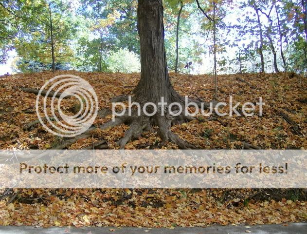


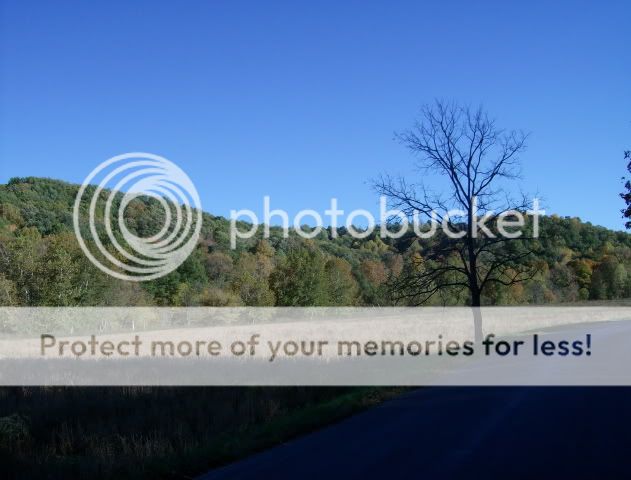


The last two are from the park. You can see that it's not quite peak time yet, so I'm tempted to go back soon.
It's beautiful down there and the weather was perfect. Enjoy some pictures.
The last two are from the park. You can see that it's not quite peak time yet, so I'm tempted to go back soon.
10-22-07, 05:37 PM
#12
Senior Member
Join Date: Mar 2004
Location: Indianapolis, IN
Posts: 121
Mentioned: 0 Post(s)
Tagged: 0 Thread(s)
Quoted: 0 Post(s)
Likes: 0
Liked 0 Times
in
0 Posts
I ended up doing a modified version of the JAWS route. Thanks to SSIndyRider for sending me some cue sheets and maps.
It's beautiful down there and the weather was perfect. Enjoy some pictures.
The last two are from the park. You can see that it's not quite peak time yet, so I'm tempted to go back soon.
It's beautiful down there and the weather was perfect. Enjoy some pictures.
The last two are from the park. You can see that it's not quite peak time yet, so I'm tempted to go back soon.
I did a modified JAWS route as well on Sunday. 65 miles and 4200' of climbing.
No pictures though.
10-22-07, 07:35 PM
#13
Je suis ici !
Join Date: Jun 2005
Location: Bloomington, Indiana
Posts: 482
Bikes: 2006 Scott Speedster S20, 2005 Trek 7200FX, 1988 White Cannondale Criterium Single Speed Conversion, 1986(?) Peugeot...I don't know what model it is, but it's a road bike
Mentioned: 0 Post(s)
Tagged: 0 Thread(s)
Quoted: 0 Post(s)
Likes: 0
Liked 0 Times
in
0 Posts
Okay, dumb question, but what is the JAWS route? Is this from a charity ride route?
Great pics DXchulo!
I got out Sunday and had a great ride...really windy though.
https://trail.motionbased.com/trail/activity/4271762
I need to start looping over to Nashville, I'm getting tired of riding up to Martinsville and back.
Great pics DXchulo!
I got out Sunday and had a great ride...really windy though.
https://trail.motionbased.com/trail/activity/4271762
I need to start looping over to Nashville, I'm getting tired of riding up to Martinsville and back.
10-23-07, 04:41 PM
#14
Senior Member
Join Date: Mar 2004
Location: Indianapolis, IN
Posts: 121
Mentioned: 0 Post(s)
Tagged: 0 Thread(s)
Quoted: 0 Post(s)
Likes: 0
Liked 0 Times
in
0 Posts
There are several ride lengths but I think the one most of us is talking about is the 100 mile route. Here is a link to the route on route slip. This isn't completely accurate so I'm going to try and create my own route to get a more accurate version of the route online.
If you are interested in doing the route, you can still see the dan henrys which are white arrows.
10-23-07, 07:15 PM
#15
Senior Member
Join Date: Sep 2006
Location: Indiana
Posts: 204
Mentioned: 0 Post(s)
Tagged: 0 Thread(s)
Quoted: 0 Post(s)
Likes: 0
Liked 0 Times
in
0 Posts
I don't know the ride history, but suspect the name may have something to do with the ride profile looking a lot like shark jaws/teeth with all the hill peaks. I think the Dan Henrys have a white shark painted with them, too. Many of the roads in that area have multiple Dan Henrys - White with yellow directions are from the Bear ride in July - another nice hilly ride, though shorter and not as severe. There are also plain white DHs from another ride crossing through.
10-23-07, 08:07 PM
#16
Je suis ici !
Join Date: Jun 2005
Location: Bloomington, Indiana
Posts: 482
Bikes: 2006 Scott Speedster S20, 2005 Trek 7200FX, 1988 White Cannondale Criterium Single Speed Conversion, 1986(?) Peugeot...I don't know what model it is, but it's a road bike
Mentioned: 0 Post(s)
Tagged: 0 Thread(s)
Quoted: 0 Post(s)
Likes: 0
Liked 0 Times
in
0 Posts
Excellent. Thanks for the replies! For some reason I've never heard of it, but I'm definitely looking forward to it for next year.
