


Fun and Safe rides in the south end of the Denver Metro Area?
 05-02-10, 01:23 PM
#1
Senior Member
Thread Starter

Join Date: Apr 2010
Location: Colorado
Posts: 72
Mentioned: 0 Post(s)
Tagged: 0 Thread(s)
Quoted: 0 Post(s)
Likes: 0
Liked 0 Times
in
0 Posts
Fun and Safe rides in the south end of the Denver Metro Area?
Hi Everyone:
Just getting back on the road after taking 8 years off to get fat and lazy. I have now lost the weight and want to get back on my road bike. I live in Castle Rock and would like to know where you ride that is fun and safe. I have checked out Hwy 105 from Sedalia to Palmer Lake and it looks fun, but want to hear about the rest of the local favorites. Thanks in advance for your input.
-Pelotoner
 05-04-10, 05:09 PM
#2
Senior Member
Join Date: Jun 2009
Location: Castle Rock, CO
Posts: 332
Bikes: '09 Gary Fisher "Kaitai, '09 Raleigh Team", '91 Trek 8700, '97 Cannondale SR500, '12 Raleigh Twin Six
Mentioned: 0 Post(s)
Tagged: 0 Thread(s)
Quoted: 0 Post(s)
Likes: 0
Liked 0 Times
in
0 Posts
What do you consider fun? What do you consider safe? How far are you willing to go?
I live in CR and commute from Target to Centennial Airport via Crowfoot Valley Rd. to the Cherry Creek Trail system. Riding across Castle Rock terrifies me, so I drive to Target from my house in Plum Creek. Crowfoot has a fairly clean, wide shoulder, but also has a lot of 50-60mph traffic. I see several bike commuters on this road. From the intersection of Founders and Crowfoot to the intersection of Crowfoot and Stroh Rd. is about 7 miles. This is where you can catch the Cherry Creek trail north to a fantastic grid of MUPs.
Going South out of town, Lake Gulch is a fun ride. It is part of the Elephant Rock course. The speed limit is 45mph, but there isn't much room to share with cagers, and many of them drive too fast. Lake Gulch to 83 or Russelville Rd., North to Franktown, and then 86 back to CR would make a good loop.
Just riding the I-25 frontage road from the intersection of Wilcox and Plum Creek is a nice, low relief, 15 mile loop if you need a quick ride to get the blood pumping.
Tomah Rd. is another portion of the E-Rock course that can be a fun challange and a scenic ride into Perry Park. I've not ridden Wolfensberger, but Tomah to 105 to Wolfensberger would be a good loop if you can stand the traffic. For a little less traffic you could take Tomah to 105, then south to cr 60, and wind your way through some of the back roads of Larkspur to get back to the I-25 frontage road.
A good shorter loop is to take Plum Creek Blvd (not Pkwy) south to Crystal Valley Ranch. Then head east to Lake Gulch and north back to Plum Creek Blvd. From the fairgrounds this is about an eight mile loop with two good climbs. If you happen to be ridding a cross or mtn. bike, there is a nice, two mile loop of single track at Rhyolite Park at the top of CVR.
The new MUP that goes from Safeway to the Meadows is around 5 miles end to end. You don't run the risk of being run over by cars, but you have to travel at appropriate MUP speeds. My wife and I ride this down and back on Sunday mornings and stop for a donut at Safeway on the way home.
For longer rides, the E-Rock map is a good guide. Keep in mind, not all of the through roads posted on the map are paved.
https://www.elephantrockride.com/cour...9ER_62_100.pdf
FWIW, I live in Plum Creek, so my routes are based on how I would ride from my house.
05-07-10, 04:42 PM
#3
Senior Member
Thread Starter
Join Date: Apr 2010
Location: Colorado
Posts: 72
Mentioned: 0 Post(s)
Tagged: 0 Thread(s)
Quoted: 0 Post(s)
Likes: 0
Liked 0 Times
in
0 Posts
Thanks for the reply.
I am just up the hill from you in Founders so you know why I asked this question.
The cars are pretty aggressive in our little town and the shoulders are not very wide if we are lucky to have any. I will check these out and see what I like.
I guess when I say safe and fun I am looking for routes that have decent shoulders and room to enjoy the ride without feeling the pressure of someone pressing me off the road.
05-07-10, 05:42 PM
#4
Banned.

Join Date: Aug 2001
Posts: 20,917
Mentioned: 0 Post(s)
Tagged: 0 Thread(s)
Quoted: 0 Post(s)
Likes: 0
Liked 12 Times
in
10 Posts
You can catch the Cherry Creek Trail just west of the Cherry Creek Bridge west of Franktown at Walker Road. I don't recommend riding on CO 86, however. This is dirt - you can park if you drive in, but a cement trail starts where Walker Road forms a cul-de-sac. SO, I would drive ther.
You can take the CC Trail north (or you can go south on Castlewood Canton Road to the State Park - short but pretty ride witrh a couple of hills, and real fun returning down the hills). The trail will eventually go through all the way to Castlewood Canyon SP. In the state park, it is terrible dirt corduroy.
Going north on the CC Trail, it is all cement - you may have to explore a bit to find the trail at a couple of cross sections - but it is there. At the Pradera Bridge, you can continue - the trail will have a sort-of gravel section, or take Bayou Gulch Road to Old Schoolhouse Road, then go for about a mile on a dirt road - easilt travelable on 700x25's past Choke Cherry Farm, then turn left on Scott Road, go across the closed bridge, and you once again catch the cement trail, which will take you north through Parker. If you don't mind Jordan Road a bit, continue across Arapahoe Road, and pick up the trail again just east of Jordan and Caley, where yo will be at Cherry Creek State Park. Go on the trail around the lake - either direction and you can pick up the trail just before it goes under I-225 and then you can head downtown to Confluence Park. This will be a fun and scenic ride. Also, Parker has several cross trails that are fun and excellent cement.
Last edited by DnvrFox; 05-07-10 at 07:02 PM.
05-13-10, 09:44 PM
#5
Senior Member
Thread Starter
Join Date: Apr 2010
Location: Colorado
Posts: 72
Mentioned: 0 Post(s)
Tagged: 0 Thread(s)
Quoted: 0 Post(s)
Likes: 0
Liked 0 Times
in
0 Posts
Can you ride around Cherry Creek State Park without paying a fee?
I need to check these routes out too, thank you so much for your reply.
I need to check these routes out too, thank you so much for your reply.
05-14-10, 09:03 AM
#6
Banned.
Join Date: Aug 2001
Posts: 20,917
Mentioned: 0 Post(s)
Tagged: 0 Thread(s)
Quoted: 0 Post(s)
Likes: 0
Liked 12 Times
in
10 Posts
The entrance at Jordan and Caley is simply a spur trail (that will eventually become a part of the completed trail- at least, that is my understanding,
No state park charges for bicycles in CO that I know of.
05-15-10, 08:25 AM
#7
Aluminum Convert
Join Date: Apr 2010
Location: Aurora/Centennial Co
Posts: 230
Bikes: Bianchi Via Nirone 7.
Mentioned: 0 Post(s)
Tagged: 0 Thread(s)
Quoted: 0 Post(s)
Likes: 0
Liked 0 Times
in
0 Posts
One of the best ways to plan your route is to go to Google maps. On the upper left part of the map there is a tab that says"More" Click on that and you will see "Bicycle" Click on that and it adds all the bicycle trails in your area as well as the roads that connect them.
There is not charge for riding through the park on a bike. All you need is a safe place to park your car outside the park. I park in a shopping center across from the park and ride downtown (13.8 miles one way) to work 2 to 3 times weekly, well except for this week with the crappy weather. Hope this helps.
There is not charge for riding through the park on a bike. All you need is a safe place to park your car outside the park. I park in a shopping center across from the park and ride downtown (13.8 miles one way) to work 2 to 3 times weekly, well except for this week with the crappy weather. Hope this helps.
05-26-10, 04:49 PM
#9
Senior Member
Join Date: Jun 2009
Location: Castle Rock, CO
Posts: 332
Bikes: '09 Gary Fisher "Kaitai, '09 Raleigh Team", '91 Trek 8700, '97 Cannondale SR500, '12 Raleigh Twin Six
Mentioned: 0 Post(s)
Tagged: 0 Thread(s)
Quoted: 0 Post(s)
Likes: 0
Liked 0 Times
in
0 Posts
Are you signing up for E-Rock? When are you trying to get out and ride? I'm trying to put some break in and fine-tune-fitting miles on my new roadbike, and would be happy to have some company. I'm not sure if I can keep up with the group that rides from CRBC on Saturday mornings.
PM sent.
PM sent.
05-26-10, 11:20 PM
#10
GeoBiker / Mapper
Join Date: Nov 2005
Location: Colorado
Posts: 117
Bikes: 2007 Gary Fisher Piranha & ~ 1984 Ross Mt Whitney
Mentioned: 0 Post(s)
Tagged: 0 Thread(s)
Quoted: 0 Post(s)
Likes: 0
Liked 0 Times
in
0 Posts
If you don't mind MUPS, you can view a trail network in Google Earth.
https://geobiking.org/Documents/GeoBiking02Apr10.kmz
https://geobiking.org/Documents/GeoBiking02Apr10.kmz
05-29-10, 08:12 PM
#11
Commuter
Join Date: Jul 2008
Location: Parker, Colorado
Posts: 140
Bikes: jamis quest, scattante rom�, raleigh c40
Mentioned: 0 Post(s)
Tagged: 0 Thread(s)
Quoted: 0 Post(s)
Likes: 0
Liked 0 Times
in
0 Posts
I can't remember if I've posted the recent news in here, but if you're a regular of the Cherry Creek trail in Parker you might have noticed the construction at the Wagon Loop "bridge to nowhere". They're extending the trail north to Arapahoe, so you no longer need to cut through the neighborhoods and the Happy Canyon Creek trail.
A trail map is here, or click here for the enormous map of the trail connection.
This will extend the trail up to Corner Store @ Arapahoe, which leaves about a one-mile stretch of busy road unfortunately to get back on Jordan and continue north through the state park. However when they do the next part of the trail, we'll finally have a trail that runs all the way from LoDo to just short of Franktown.
05-29-10, 08:17 PM
#12
Commuter
Join Date: Jul 2008
Location: Parker, Colorado
Posts: 140
Bikes: jamis quest, scattante rom�, raleigh c40
Mentioned: 0 Post(s)
Tagged: 0 Thread(s)
Quoted: 0 Post(s)
Likes: 0
Liked 0 Times
in
0 Posts
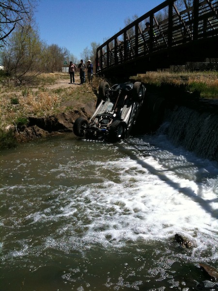
Almost forgot, one of the reasons the PJMD were wanting buy that land is because the current owners take real bad care of the creek through there, the cattle really tear it up and there are always people tearing it up with their cars, like these yahoos:
05-29-10, 08:26 PM
#13
Banned.
Join Date: Aug 2001
Posts: 20,917
Mentioned: 0 Post(s)
Tagged: 0 Thread(s)
Quoted: 0 Post(s)
Likes: 0
Liked 12 Times
in
10 Posts
I can't remember if I've posted the recent news in here, but if you're a regular of the Cherry Creek trail in Parker you might have noticed the construction at the Wagon Loop "bridge to nowhere". They're extending the trail north to Arapahoe, so you no longer need to cut through the neighborhoods and the Happy Canyon Creek trail.
A trail map is here, or click here for the enormous map of the trail connection.
This will extend the trail up to Corner Store @ Arapahoe, which leaves about a one-mile stretch of busy road unfortunately to get back on Jordan and continue north through the state park. However when they do the next part of the trail, we'll finally have a trail that runs all the way from LoDo to just short of Franktown.
A trail map is here, or click here for the enormous map of the trail connection.
This will extend the trail up to Corner Store @ Arapahoe, which leaves about a one-mile stretch of busy road unfortunately to get back on Jordan and continue north through the state park. However when they do the next part of the trail, we'll finally have a trail that runs all the way from LoDo to just short of Franktown.
I've never seen a car in the creek around there. Interesting. Isn't the PJMD a new organization**********

Thread
Thread Starter
Forum
Replies
Last Post
daihard
Pacific Northwest
5
05-05-15 12:59 AM
