


nyc fdr greenways from 86th - 77th...
 08-26-08, 02:59 PM
#1
Senior Member
Thread Starter
Join Date: Aug 2008
Posts: 749
Mentioned: 0 Post(s)
Tagged: 0 Thread(s)
Quoted: 0 Post(s)
Likes: 0
Liked 0 Times
in
0 Posts
nyc fdr greenways from 86th - 77th...
i was looking to bike down from the fdr greenway from 102nd down to 42nd st. but when i look at the map...there is a greenways all the way from 125th down to 63rd on the fdr greenway. i always walk my dog on the fdr greenway and take my dog to the dog park on 86th carl schurz park. on 90th st...the greenway start to deviate from the fdr path where this is an uphill climb...then you are biking/walking above the fdr where cars is below u...until u hit a dead end somewhere on 84th st/gracie square. i dont see how you can travel farther south..yet it is indicated a greenways down to 63rd st. i do see a little side st. by the name of "john finley way"..from 84th down to 81st. is that the continuation of greenways path? you can check out google map (satellite view) and see it for yourself if you dont believe me. someone who bike on the fdr between 77th st to 86th st...please let me know!
 08-26-08, 05:52 PM
#2
Car-Free Flatlander

Join Date: Sep 2004
Location: Below 14th Street
Posts: 1,976
Bikes: Sirrus
Mentioned: 0 Post(s)
Tagged: 0 Thread(s)
Quoted: 0 Post(s)
Likes: 0
Liked 0 Times
in
0 Posts
It's not a dead end. There's a staircase that leads down to grade level and follows the FDR down to 63rd Street. On the outher rail, there's even a metal track to roll a bike up or down the two flights. The last time I was there, it ended with a pedestrian bridge at 63rd that exits onto 63rd and York Avenue. I think they may have been doing some construction to extend the bike path down to around 42nd Street.
Last edited by Stacy; 08-26-08 at 05:56 PM.
08-26-08, 06:20 PM
#3

Professional Fuss-Budget

I forget the exact route, but you can cycle from Battery Park to the northernmost tip of Manhattan without having to carry your bike.
Last I recall, the spot(s) you're talking about are all marked. Should be pretty easy to figure it out, or worst case scenario follow your fellow bikers.
Last I recall, the spot(s) you're talking about are all marked. Should be pretty easy to figure it out, or worst case scenario follow your fellow bikers.
08-26-08, 06:45 PM
#4

Drops small screws
Heading north on the east, there's a runner up the side that you can push your bike up while you're climbing the stairs on foot. A little later, the greenway disappears for a while and you're on city streets before reconnecting.
Heading north on the west, there's a series of broad, flat steps from the end of the greenway down to Dyckman/Seaman. There's no runner, but you can roll your bike relatively easily next to the staircase. Or you can just carry it like George ("Air") does. You're on city streets after that, whether you're heading east to pick up the greenway on the other side or heading north to the very top of the island--so it also depends on what you mean by "the northernmost tip of Manhattan."
There's also a little-known spur off the western side, just before the Little Red Lighthouse, that takes you up to 177th and Haven Ave. A pretty cool little secret route, but it's got both stairs and homeless encampments where no one can see the ambush.
08-26-08, 07:23 PM
#5
Senior Member
Thread Starter
Join Date: Aug 2008
Posts: 749
Mentioned: 0 Post(s)
Tagged: 0 Thread(s)
Quoted: 0 Post(s)
Likes: 0
Liked 0 Times
in
0 Posts
It's not a dead end. There's a staircase that leads down to grade level and follows the FDR down to 63rd Street. On the outher rail, there's even a metal track to roll a bike up or down the two flights. The last time I was there, it ended with a pedestrian bridge at 63rd that exits onto 63rd and York Avenue. I think they may have been doing some construction to extend the bike path down to around 42nd Street.

Last edited by vincentnyc; 08-26-08 at 07:35 PM.
08-26-08, 11:46 PM
#6
Car-Free Flatlander
Join Date: Sep 2004
Location: Below 14th Street
Posts: 1,976
Bikes: Sirrus
Mentioned: 0 Post(s)
Tagged: 0 Thread(s)
Quoted: 0 Post(s)
Likes: 0
Liked 0 Times
in
0 Posts
https://maps.google.com/maps?ll=40.77...z=19&t=h&hl=en
08-27-08, 06:53 AM
#7
Senior Member
Thread Starter
Join Date: Aug 2008
Posts: 749
Mentioned: 0 Post(s)
Tagged: 0 Thread(s)
Quoted: 0 Post(s)
Likes: 0
Liked 0 Times
in
0 Posts
In Google Earth, it looks like it's right at 81st Street. In fact, Google Earth even has some photos of the FDR taken from the overpass. Heres the view in Google Maps. Notice the path that runs east of the FDR with trees?
https://maps.google.com/maps?ll=40.77...z=19&t=h&hl=en
https://maps.google.com/maps?ll=40.77...z=19&t=h&hl=en
08-27-08, 11:20 AM
#8
Bubba Ho-Tep's BFF

Join Date: Feb 2006
Location: Escaped NYC
Posts: 354
Bikes: Brompton & a Bianchi Volpe do-it-all-bike
Mentioned: 0 Post(s)
Tagged: 0 Thread(s)
Quoted: 0 Post(s)
Likes: 0
Liked 0 Times
in
0 Posts
The greenway's southern tip does end at 63rd, they've been doing construction between 60th and 63rd for ages. I don't think they'll ever get that done at the rate they've been going.
The east side greenway isn't much use for travelling north/south by bike in Manhattan. I'm still looking for a way to get from work on the Upper East Side down to Union Square without feeling like I'm taking part in Death Race 3 billion...
08-27-08, 11:35 AM
#9
Drops small screws
Maybe through Central Park into the 60s, over to the Hudson greenway, down to 14th and then inland?
08-27-08, 11:37 AM
#10
Senior Member
Join Date: Mar 2007
Location: Philadelphia
Posts: 221
Bikes: Surly Pacer, Trek 520 & gaspipe fixed gear beater
Mentioned: 0 Post(s)
Tagged: 0 Thread(s)
Quoted: 0 Post(s)
Likes: 0
Liked 0 Times
in
0 Posts
https://en.wikipedia.org/wiki/Marble_Hill,_Manhattan
08-27-08, 12:13 PM
#11
Senior Member
Thread Starter
Join Date: Aug 2008
Posts: 749
Mentioned: 0 Post(s)
Tagged: 0 Thread(s)
Quoted: 0 Post(s)
Likes: 0
Liked 0 Times
in
0 Posts
where is the raised greenway? yes there is a fence on 84th...it is locked...that's y i called it dead end. i think if you try to climb over the fence...the security guards from those million dollar condo building will call 911 on ur ass.
08-27-08, 12:17 PM
#12
Senior Member
Thread Starter
Join Date: Aug 2008
Posts: 749
Mentioned: 0 Post(s)
Tagged: 0 Thread(s)
Quoted: 0 Post(s)
Likes: 0
Liked 0 Times
in
0 Posts
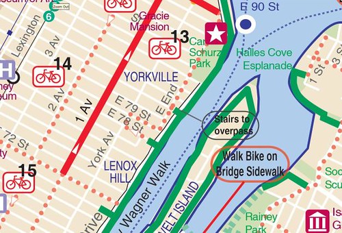
i dont really see there is a way around this...from the map i'm looking at...once u hit 84th on carlz shurz park..u gotta make a right to gracie square..then make a left on east end ave...then head south 81st...then make another left across the walk path to the fdr green on 81st...am i correct or wrong?
08-27-08, 12:18 PM
#13
Senior Member
Thread Starter
Join Date: Aug 2008
Posts: 749
Mentioned: 0 Post(s)
Tagged: 0 Thread(s)
Quoted: 0 Post(s)
Likes: 0
Liked 0 Times
in
0 Posts
i'm gonna walk my dog this weekend and check it out for myself...last time i was over on 84th...there was a fence....i dont see a way around this...i'm not getting my hope up.
08-27-08, 01:12 PM
#14
Senior Member
Join Date: Mar 2007
Location: Philadelphia
Posts: 221
Bikes: Surly Pacer, Trek 520 & gaspipe fixed gear beater
Mentioned: 0 Post(s)
Tagged: 0 Thread(s)
Quoted: 0 Post(s)
Likes: 0
Liked 0 Times
in
0 Posts
It can definitely be done. When you get to fence at 84th st. at the end alongside of Carl Shurz Park you do not have leave the greenway and go out onto East End Ave. There is an opening in the fence. It is always open. Go through it and make a left. There is a staircase (with rails for rolling your bike up or down) and it connects to the greenway south of 84th. You cannot see this detail on google maps because the building at 84th st. blocks the satellite view of the staircase.
08-27-08, 01:21 PM
#15
Bubba Ho-Tep's BFF
Join Date: Feb 2006
Location: Escaped NYC
Posts: 354
Bikes: Brompton & a Bianchi Volpe do-it-all-bike
Mentioned: 0 Post(s)
Tagged: 0 Thread(s)
Quoted: 0 Post(s)
Likes: 0
Liked 0 Times
in
0 Posts
08-27-08, 02:20 PM
#16
Senior Member
Thread Starter
Join Date: Aug 2008
Posts: 749
Mentioned: 0 Post(s)
Tagged: 0 Thread(s)
Quoted: 0 Post(s)
Likes: 0
Liked 0 Times
in
0 Posts
...There is an opening in the fence. It is always open. Go through it and make a left. There is a staircase (with rails for rolling your bike up or down) and it connects to the greenway south of 84th. You cannot see this detail on google maps because the building at 84th st. blocks the satellite view of the staircase.
Last edited by vincentnyc; 08-27-08 at 02:45 PM.
08-27-08, 03:16 PM
#17
Car-Free Flatlander
Join Date: Sep 2004
Location: Below 14th Street
Posts: 1,976
Bikes: Sirrus
Mentioned: 0 Post(s)
Tagged: 0 Thread(s)
Quoted: 0 Post(s)
Likes: 0
Liked 0 Times
in
0 Posts
i dont really see there is a way around this...from the map i'm looking at...once u hit 84th on carlz shurz park..u gotta make a right to gracie square..then make a left on east end ave...then head south 81st...then make another left across the walk path to the fdr green on 81st...am i correct or wrong?
You can't see the entire route on the map because the walkway passes under some kind of building structure where the fence is. I've only been there during daylight so it's possible they close it at night when they close the park, but I believe there's still access to the bridge and stairway via 81st Street.
08-30-08, 10:25 PM
#18
Car-Free Flatlander
Join Date: Sep 2004
Location: Below 14th Street
Posts: 1,976
Bikes: Sirrus
Mentioned: 0 Post(s)
Tagged: 0 Thread(s)
Quoted: 0 Post(s)
Likes: 0
Liked 0 Times
in
0 Posts
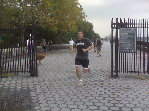
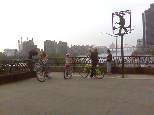
The southern gate has a green sign that says Manhattan Waterfront Greenway.
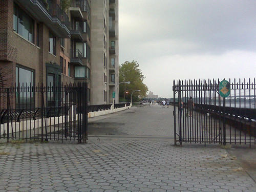
Then pass under this structure
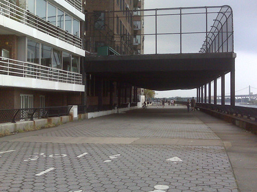
The staircase down to the greenway is at the end of John Finley Walk on your left.
 08-31-08, 12:42 AM
#20
Car-Free Flatlander
Join Date: Sep 2004
Location: Below 14th Street
Posts: 1,976
Bikes: Sirrus
Mentioned: 0 Post(s)
Tagged: 0 Thread(s)
Quoted: 0 Post(s)
Likes: 0
Liked 0 Times
in
0 Posts
It's amazing how confusing this can be until you either follow someone, or figure it out on your own. Then once you've done it, you feel like you've always known the route 
09-01-08, 01:08 PM
#21

Destroyer of Wheels

So very, very true! First few times I did a Manhattan loop I didn't go west enough before going up to 155th and walked up 100-200 stairs with my 50 pound mtb. Boy was I happy to find a different route there!
__________________
The Almighty Clyde FAQ || Northeast Index
eTrex Vista References || Road Reference
It's the year of the enema!
The Almighty Clyde FAQ || Northeast Index
eTrex Vista References || Road Reference
It's the year of the enema!
09-01-08, 02:25 PM
#22
Car-Free Flatlander
Join Date: Sep 2004
Location: Below 14th Street
Posts: 1,976
Bikes: Sirrus
Mentioned: 0 Post(s)
Tagged: 0 Thread(s)
Quoted: 0 Post(s)
Likes: 0
Liked 0 Times
in
0 Posts
I made the same mistake but didn't find any stairs. I can't remember how many block I had to double back before I found the right route.
09-01-08, 03:40 PM
#23
Destroyer of Wheels
They were not easy - to find OR go up!
__________________
The Almighty Clyde FAQ || Northeast Index
eTrex Vista References || Road Reference
It's the year of the enema!
The Almighty Clyde FAQ || Northeast Index
eTrex Vista References || Road Reference
It's the year of the enema!
09-01-08, 07:42 PM
#24
another cat...FAB!

Join Date: Jun 2005
Location: 1st star to the right...
Posts: 1,381
Bikes: Merlin Ti Build, Trek Y-50, Bianchi Titanium Build, Custom Cuevas Road bike
Mentioned: 0 Post(s)
Tagged: 0 Thread(s)
Quoted: 0 Post(s)
Liked 0 Times
in
0 Posts
In Google Earth, it looks like it's right at 81st Street. In fact, Google Earth even has some photos of the FDR taken from the overpass. Heres the view in Google Maps. Notice the path that runs east of the FDR with trees?
https://maps.google.com/maps?ll=40.77...z=19&t=h&hl=en
https://maps.google.com/maps?ll=40.77...z=19&t=h&hl=en
Here's the links to the current maps:
https://www.nyc.gov/html/dot/download...pfront2008.pdf
https://www.nyc.gov/html/dot/download...apback2008.pdf
__________________

Change the course of the Epidemic | The Merlin | Merlin XLM | Bianchi Ti | CyclePeople
Don't take it off until there's a cure LIVESTRONG | pay it forward | Cats | NEW Gallery
Don't take it off until there's a cure LIVESTRONG | pay it forward | Cats | NEW Gallery
9
