


Long Island - Old Bethpage to Penn Station in Manhattan
 05-19-10, 04:25 PM
#1

Senior Member
Thread Starter

Join Date: May 2007
Location: Highland Park, NJ, USA
Posts: 3,798
Bikes: "Hildy", a Novara Randonee touring bike; a 16-speed Bike Friday Tikit; and a Specialized Stumpjumper frame-based built-up MTB, now serving as the kid-carrier, grocery-getter.
Mentioned: 0 Post(s)
Tagged: 0 Thread(s)
Quoted: 11 Post(s)
Likes: 0
Liked 1 Time
in
1 Post
Long Island - Old Bethpage to Penn Station in Manhattan
The thread title says it all - I'm building a route from the Battle Row Campground in Old Bethpage in Nassau County to NY Penn Station. This is the final day of a planned tour from Boston to New York City, and I'll take the train home from Penn Station. (Thanks again for the great advice in this thread for an earlier day of riding.)
The route that Google maps gives me is around 36 miles but looks somewhat dull. At the cost of an extra 6 or 67 miles, I can ride through Gateway National Recreation area. I may be pretty wiped by this point, so I'd like to keep the route as flat and easy as I can, but not at the cost of it becoming boring.
I'd prefer to avoid as much stop-and-go city riding as I can. If all goes according to plan, I'll be riding this on Saturday May 29th. I have the Long Island bike map, so I can wing it if need be, but I'd appreciate thoughts form anyone who rides in this area. What roads are the most interesting?
Topographically, Long Island looks to be pretty flat, so I may be best off riding down the center of the island to stay away from shore crosswinds, is this correct? Are the shore areas more interesting? Are there areas I want to stay away from entirely?
Thanks!
__________________
Tour Journals, Blog, ride pix
My bands:
Tour Journals, Blog, ride pix
My bands:
- Uke On! - ukulele duo - Videos
- Ukulele Abyss - ukulele cover videos - Videos
- Baroque and Hungry's (Celtic fusion) full-length studio album Mended.
- Artistic Differences - 8-track EP Dreams of Bile and Blood.
 05-19-10, 06:18 PM
#2
Senior Member
Thread Starter
Join Date: May 2007
Location: Highland Park, NJ, USA
Posts: 3,798
Bikes: "Hildy", a Novara Randonee touring bike; a 16-speed Bike Friday Tikit; and a Specialized Stumpjumper frame-based built-up MTB, now serving as the kid-carrier, grocery-getter.
Mentioned: 0 Post(s)
Tagged: 0 Thread(s)
Quoted: 11 Post(s)
Likes: 0
Liked 1 Time
in
1 Post
Another thought: I have no need to ride to Penn Station itself. I've ridden from Brooklyn into manhattan, and through Manhattan several times, and it holds no novelty. I could ride to, say, Gateway recreation area or Jamaica Bay, then take the subway to Penn Station.
__________________
Tour Journals, Blog, ride pix
My bands:
Tour Journals, Blog, ride pix
My bands:
- Uke On! - ukulele duo - Videos
- Ukulele Abyss - ukulele cover videos - Videos
- Baroque and Hungry's (Celtic fusion) full-length studio album Mended.
- Artistic Differences - 8-track EP Dreams of Bile and Blood.
05-19-10, 06:39 PM
#3
Senior Member
Join Date: Dec 2007
Posts: 100
Mentioned: 0 Post(s)
Tagged: 0 Thread(s)
Quoted: 0 Post(s)
Likes: 0
Liked 0 Times
in
0 Posts
LI riding
The most direct way to the city would be to pick up round swamp rd north in bethpage to the LIE service rd west. Just go west till you reach little neck parkway , hang a left take little neck pkway to union tpke make a right, take that up to queens bvd make right take Q ns BVD up to the 59st bridge! mileage is approx 45- 55 miles. If looking for hilly roads and country side riding ,then take round swamp north and on the map find your way to 25a then go west on 25a to the 59 st bridge.
good luck
good luck
05-19-10, 06:50 PM
#4
Senior Member
Thread Starter
Join Date: May 2007
Location: Highland Park, NJ, USA
Posts: 3,798
Bikes: "Hildy", a Novara Randonee touring bike; a 16-speed Bike Friday Tikit; and a Specialized Stumpjumper frame-based built-up MTB, now serving as the kid-carrier, grocery-getter.
Mentioned: 0 Post(s)
Tagged: 0 Thread(s)
Quoted: 11 Post(s)
Likes: 0
Liked 1 Time
in
1 Post
Is this why the LI bike map lists the LI expressway as a bikeable road?
__________________
Tour Journals, Blog, ride pix
My bands:
Tour Journals, Blog, ride pix
My bands:
- Uke On! - ukulele duo - Videos
- Ukulele Abyss - ukulele cover videos - Videos
- Baroque and Hungry's (Celtic fusion) full-length studio album Mended.
- Artistic Differences - 8-track EP Dreams of Bile and Blood.
05-19-10, 08:50 PM
#5
Senior Member
Join Date: Nov 2009
Posts: 555
Mentioned: 0 Post(s)
Tagged: 0 Thread(s)
Quoted: 31 Post(s)
Likes: 0
Liked 10 Times
in
8 Posts
The LIE Service Road is one-way, has a shoulder and limited cross-traffic. In addition to Google Maps bicycle routing, I suggest you also use aerial and street views to check out what are good biking roads. It also does not have the rider looking for 3.25 turns per mile. It's basic problem is that it makes for a sterile ride.
You indicated that taking the subway is a reasonable alternative to crossing the East River by bike. I'd suggest that you take the F train from 179th St directly to 34th St & 6th Ave, which is 1 block from Penn Sta. After you get onto Union Tpk via the Little Neck Pkwy as suggested by Mr. breaking away, turn left on 188th St, then right on Midland Pkwy and right on Hillside Ave. The elevator entrance to the 179th St Station is 1 block (179th Pl) on the other side of Hillside. There are also elevators at the 34th St Station.
05-19-10, 11:34 PM
#6
Se�or Member
Join Date: Aug 2006
Location: Long Island, NY
Posts: 353
Mentioned: 0 Post(s)
Tagged: 0 Thread(s)
Quoted: 1 Post(s)
Likes: 0
Liked 0 Times
in
0 Posts
Just a word on that stretch of Belt Parkway bikeway on your planned route...
DON'T GO THERE.
That stretch of the Belt Parkway bike path is the foulest place you can ever ride. It's sited right next to a garbage landfill.
The runoff from the landfill mounds collect on the poorly-drained bike path, and the first (and last!) time I've ridden there, I have no idea what's in that toxic muck my bike wheels were forced to roll through.
Whichever city planning bonehead bureaucrat put that bike path there needs to be smacked upside the head.
05-20-10, 11:04 AM
#7
Senior Member
I don't remember that stretch of the Belt being QUITE as bad as LongIslandTom describes, but then again, I haven't ridden it in a few years. This winter, however, a major portion of the Belt Parkway bike path (further west) was reportedly washed away. I'm not sure of the status at this time.
My personal route into Manhattan is as follows, although others have improved on it in previous threads. I think these were in response to one of your previous posts, Neil, so you may want to go back to them:
My question, for some time, has been whether the little dirt path that connected the Northern Blvd bridge with the industrial area adjacent to the Flushing Bay Promenade survived some recent major construction. If it DIDN'T, you'll have to work around it by continuing on Northern Blvd to a point where you can make a right under the Grand Central Parkway and connect with the promenade.
My personal route into Manhattan is as follows, although others have improved on it in previous threads. I think these were in response to one of your previous posts, Neil, so you may want to go back to them:
- LIE to Douglaston Parkway. Make right to Northern Boulevard.
- Left onto Northern Boulevard and continue to Cross Island Parkway (entrance to path)
- At end of path, make left on Utopia Parkway and go up hill to Cross Island Service Road.
- Make right and take Cross Island Service Road to 147 Street.
- Make left and cross over the parkway.
- At 14 Ave, make right and cross over the Whitestone Expressway.
- Make left onto westbound service road for Whitestone Expressway and take it all the way to College Point Blvd.
- Make left onto College Point.
- When you reach the overpass for Northern Blvd. Make a left onto small road marked “Northern Blvd” (different road...not THE Northern Blvd)
- Go to the end of this road and make a sharp right (actually a U-turn) to get on the bridge.
- Cross the bridge on the sidewalk and bear right at the end of the ramp. You’ll end up in an industrial area (don’t know the street).
- Continue heading west (straight / bear left) and you’ll shortly reach the entrance to the Flushing Bay Promenade.
- Take the Promenade to the end and cross over Grand Central Parkway (overpass) to Ditmars.
- Make a right onto Ditmars and continue to 82nd Street. (This will get you past the airport)
- At 82nd Street, make a right to cross the GCP again and make a left onto Astoria Blvd. (the westbound side)
- Take Astoria Blvd. To 31st Street and make a left.
- At Queens Plaza North, make a right and cross to the eastbound side of the lane leading onto the 59th Street Bridge. Auto traffic will be heading toward you, but this is the side of the bridge that is open to cyclists.
- Cross the bridge into Manhattan
My question, for some time, has been whether the little dirt path that connected the Northern Blvd bridge with the industrial area adjacent to the Flushing Bay Promenade survived some recent major construction. If it DIDN'T, you'll have to work around it by continuing on Northern Blvd to a point where you can make a right under the Grand Central Parkway and connect with the promenade.
Last edited by Papa Tom; 05-20-10 at 11:07 AM. Reason: Slippery fingers...lots of typos!
05-20-10, 01:15 PM
#8
Senior Member
Thread Starter
Join Date: May 2007
Location: Highland Park, NJ, USA
Posts: 3,798
Bikes: "Hildy", a Novara Randonee touring bike; a 16-speed Bike Friday Tikit; and a Specialized Stumpjumper frame-based built-up MTB, now serving as the kid-carrier, grocery-getter.
Mentioned: 0 Post(s)
Tagged: 0 Thread(s)
Quoted: 11 Post(s)
Likes: 0
Liked 1 Time
in
1 Post
I'm pretty hesitant to ride over the Queensboro bridge, but it is the quickest way into Manhattan. This looks like quite the urban adventure to a Jersey boy! I forsee getting lost at least once or three times. (It wouldn't be a proper tour if I didn't get lost at least a little.

__________________
Tour Journals, Blog, ride pix
My bands:
Tour Journals, Blog, ride pix
My bands:
- Uke On! - ukulele duo - Videos
- Ukulele Abyss - ukulele cover videos - Videos
- Baroque and Hungry's (Celtic fusion) full-length studio album Mended.
- Artistic Differences - 8-track EP Dreams of Bile and Blood.
05-20-10, 04:00 PM
#9
Senior Member
Riding over the Queensboro is no problem, as there is a bike path on the inbound side. The problem, the last time I rode it (maybe 3 years ago), was fighting the traffic getting ON TO the bridge. My route between the end of the Flushing Bay Promenade and the bridge cuts out as much of Queens Blvd (the "Boulevard of Death") as possible, but it has been torn apart and improved upon by many other riders more experienced with the boro of Queens. Can anybody help Neil out here?
05-20-10, 04:02 PM
#10
Senior Member
By the way, if you're looking for a leisurely ride to cool down once you get to Manhattan, perhaps the Hudson River Greenway (West Side) might interest you.
05-20-10, 07:30 PM
#11
Senior Member
Thread Starter
Join Date: May 2007
Location: Highland Park, NJ, USA
Posts: 3,798
Bikes: "Hildy", a Novara Randonee touring bike; a 16-speed Bike Friday Tikit; and a Specialized Stumpjumper frame-based built-up MTB, now serving as the kid-carrier, grocery-getter.
Mentioned: 0 Post(s)
Tagged: 0 Thread(s)
Quoted: 11 Post(s)
Likes: 0
Liked 1 Time
in
1 Post
__________________
Tour Journals, Blog, ride pix
My bands:
Tour Journals, Blog, ride pix
My bands:
- Uke On! - ukulele duo - Videos
- Ukulele Abyss - ukulele cover videos - Videos
- Baroque and Hungry's (Celtic fusion) full-length studio album Mended.
- Artistic Differences - 8-track EP Dreams of Bile and Blood.
05-21-10, 05:30 AM
#12
Senior Member
Join Date: May 2009
Posts: 3,685
Bikes: S5 VWD & SL-7 S works Red.
Mentioned: 1 Post(s)
Tagged: 0 Thread(s)
Quoted: 52 Post(s)
Liked 0 Times
in
0 Posts
My question, for some time, has been whether the little dirt path that connected the Northern Blvd bridge with the industrial area adjacent to the Flushing Bay Promenade survived some recent major construction. If it DIDN'T, you'll have to work around it by continuing on Northern Blvd to a point where you can make a right under the Grand Central Parkway and connect with the promenade.[/QUOTE]
If you are referring to the little dirt path at the end of the side walk ramp, yes it still in place. The only problem is that it is covered with glass.
https://www.bing.com/maps/?FORM=Z9LH8...EuMDI3Mzc0MjY3
If you are referring to the little dirt path at the end of the side walk ramp, yes it still in place. The only problem is that it is covered with glass.
https://www.bing.com/maps/?FORM=Z9LH8...EuMDI3Mzc0MjY3
05-21-10, 06:10 AM
#13
Senior Member
>>>If you are referring to the little dirt path at the end of the side walk ramp, yes it still in place. The only problem is that it is covered with glass.https://www.bing.com/maps/?FORM=Z9LH8...EuMDI3Mzc0MjY3<<<<<
I can't really see it in the aerial shot, but it's good to know that it's still there. That's assuming, of course, that this photo was taken AFTER the construction. Have you been there, personally?
I can't really see it in the aerial shot, but it's good to know that it's still there. That's assuming, of course, that this photo was taken AFTER the construction. Have you been there, personally?
05-21-10, 06:39 PM
#14
Senior Member
Join Date: May 2009
Posts: 3,685
Bikes: S5 VWD & SL-7 S works Red.
Mentioned: 1 Post(s)
Tagged: 0 Thread(s)
Quoted: 52 Post(s)
Liked 0 Times
in
0 Posts
>>>If you are referring to the little dirt path at the end of the side walk ramp, yes it still in place. The only problem is that it is covered with glass.https://www.bing.com/maps/?FORM=Z9LH8...EuMDI3Mzc0MjY3<<<<<
I can't really see it in the aerial shot, but it's good to know that it's still there. That's assuming, of course, that this photo was taken AFTER the construction. Have you been there, personally?
I can't really see it in the aerial shot, but it's good to know that it's still there. That's assuming, of course, that this photo was taken AFTER the construction. Have you been there, personally?
Last edited by v70cat; 05-21-10 at 06:42 PM.
05-21-10, 11:19 PM
#15
Senior Member
Thread Starter
Join Date: May 2007
Location: Highland Park, NJ, USA
Posts: 3,798
Bikes: "Hildy", a Novara Randonee touring bike; a 16-speed Bike Friday Tikit; and a Specialized Stumpjumper frame-based built-up MTB, now serving as the kid-carrier, grocery-getter.
Mentioned: 0 Post(s)
Tagged: 0 Thread(s)
Quoted: 11 Post(s)
Likes: 0
Liked 1 Time
in
1 Post
My guess now is that I'll use Papa Tom's route or something close to it. I'm probably going to check this thread again on Wednesday, my rest day in Hartford. If the tour goes as planned, I'll be riding this on Saturday May 29th. If anyone wants to ride any of this in Long Island or Queens with me, PM me or email me! Riding in urban areas is always more fun with people who live there.
__________________
Tour Journals, Blog, ride pix
My bands:
Tour Journals, Blog, ride pix
My bands:
- Uke On! - ukulele duo - Videos
- Ukulele Abyss - ukulele cover videos - Videos
- Baroque and Hungry's (Celtic fusion) full-length studio album Mended.
- Artistic Differences - 8-track EP Dreams of Bile and Blood.
05-22-10, 08:55 PM
#16
Senior Member
Join Date: Mar 2007
Location: Long Island, NY
Posts: 636
Mentioned: 0 Post(s)
Tagged: 0 Thread(s)
Quoted: 8 Post(s)
Likes: 0
Liked 0 Times
in
0 Posts
A good route from Battle Row to the LIE Service Rd. west, avoiding the need to navigate the "detour" of the missing service road if taking Round Swamp:
- West on Old Bethpage Rd.
- Left on Haypath, cross Plainview Rd.
- Right on Gerhard (north) - becomes Central Park Rd. after Old Country
- To end at Mannetto Hill Rd. Go Left
- To end at Woodbury Rd., Go Left
- Immediate Right on Angel Way, go to end, go left under highway, road becomes LIE Service Rd west.
(Edited for typo - thanks Tom).
SB
Last edited by Lightingguy; 05-23-10 at 07:32 AM.
05-23-10, 04:35 AM
#17
Senior Member
>>>>Immediate Right on Angle Way<<<<
In case you're using GPS or navigation software, it's actually "Angel" Way. At the end of Angel Way, go left under the highway (Rt. 135), pass my old Jr. High School, and continue around the winding road a bit of a distance until you come up to the Syosset Public Library. Continue straight, cross South Oyster Bay Road onto what is called Miller Road and just keep going straight until it becomes the LIE Service Road.
In case you're using GPS or navigation software, it's actually "Angel" Way. At the end of Angel Way, go left under the highway (Rt. 135), pass my old Jr. High School, and continue around the winding road a bit of a distance until you come up to the Syosset Public Library. Continue straight, cross South Oyster Bay Road onto what is called Miller Road and just keep going straight until it becomes the LIE Service Road.
05-29-10, 10:08 PM
#18
Junior Member
Join Date: May 2010
Posts: 11
Mentioned: 0 Post(s)
Tagged: 0 Thread(s)
Quoted: 0 Post(s)
Likes: 0
Liked 0 Times
in
0 Posts
Check out this page for cycling routes on the tip of Long Island
https://www.bikenewengland.com/long_island.html
https://www.bikenewengland.com/long_island.html
05-30-10, 06:05 AM
#19
Senior Member
Thread Starter
Join Date: May 2007
Location: Highland Park, NJ, USA
Posts: 3,798
Bikes: "Hildy", a Novara Randonee touring bike; a 16-speed Bike Friday Tikit; and a Specialized Stumpjumper frame-based built-up MTB, now serving as the kid-carrier, grocery-getter.
Mentioned: 0 Post(s)
Tagged: 0 Thread(s)
Quoted: 11 Post(s)
Likes: 0
Liked 1 Time
in
1 Post
I ended up spending the night in a hotel in Stony Brook, when if became obvious that I wasn't going to make Old Bethpage before the office closed. (They need to see your ID before they can let you camp there or some such idiocy.) The following day, I ended up taking bicycle route 25/25A until I got to Cold Spring Harbor, then following the car routes until I caught up with the Douglaston Parkway and Papa Tom's route. However, 25A gets pretty hairy for bikes where it crosses Hempstead Harbor and goes down to one narrow lane where there's construction; I had cars backed up and honking for about a mile while I crossed the water. I got off that road fast and switched to the LIE service road.
Great route, Tom! Unfortunately, I lost the thread by Citi Field. Unable to find Ditmars, I switched to using the NYC bike map to get to the bridge. Queens has signs all over f\directing bicyclists to the Queensboro bridge. Traffic was stop-and-go, but at least I was moving.
The bridge crossing is an enclosed bike/ped lane on the lower level.
I rode 73 miles on that day, and it started raining only a few blocks from Penn Station. I'll post pics soon. Thanks again!
__________________
Tour Journals, Blog, ride pix
My bands:
Tour Journals, Blog, ride pix
My bands:
- Uke On! - ukulele duo - Videos
- Ukulele Abyss - ukulele cover videos - Videos
- Baroque and Hungry's (Celtic fusion) full-length studio album Mended.
- Artistic Differences - 8-track EP Dreams of Bile and Blood.
05-30-10, 01:53 PM
#20
Senior Member
>>>>However, 25A gets pretty hairy for bikes where it crosses Hempstead Harbor and goes down to one narrow lane where there's construction;<<<<
Huh??? If you followed MY route, what were you doing crossing Hempstead Harbor? That viaduct is a horror when it's NOT under construction. Douglaston Parkway dumps you onto Northern Blvd (25A) WAY west of that! But yes, 25A is pretty busy for the short distance between Douglaston Parkway and the Cross Island Pkwy bike path.
Huh??? If you followed MY route, what were you doing crossing Hempstead Harbor? That viaduct is a horror when it's NOT under construction. Douglaston Parkway dumps you onto Northern Blvd (25A) WAY west of that! But yes, 25A is pretty busy for the short distance between Douglaston Parkway and the Cross Island Pkwy bike path.
05-30-10, 10:23 PM
#21
Senior Member
Thread Starter
Join Date: May 2007
Location: Highland Park, NJ, USA
Posts: 3,798
Bikes: "Hildy", a Novara Randonee touring bike; a 16-speed Bike Friday Tikit; and a Specialized Stumpjumper frame-based built-up MTB, now serving as the kid-carrier, grocery-getter.
Mentioned: 0 Post(s)
Tagged: 0 Thread(s)
Quoted: 11 Post(s)
Likes: 0
Liked 1 Time
in
1 Post
>>>>However, 25A gets pretty hairy for bikes where it crosses Hempstead Harbor and goes down to one narrow lane where there's construction;<<<<
Huh??? If you followed MY route, what were you doing crossing Hempstead Harbor? That viaduct is a horror when it's NOT under construction. Douglaston Parkway dumps you onto Northern Blvd (25A) WAY west of that! But yes, 25A is pretty busy for the short distance between Douglaston Parkway and the Cross Island Pkwy bike path.
Huh??? If you followed MY route, what were you doing crossing Hempstead Harbor? That viaduct is a horror when it's NOT under construction. Douglaston Parkway dumps you onto Northern Blvd (25A) WAY west of that! But yes, 25A is pretty busy for the short distance between Douglaston Parkway and the Cross Island Pkwy bike path.
Edit: Just a guess, but I think I lost the thread of the directions because of new streets near Citi field? The directions were spot-on until that point.
__________________
Tour Journals, Blog, ride pix
My bands:
Tour Journals, Blog, ride pix
My bands:
- Uke On! - ukulele duo - Videos
- Ukulele Abyss - ukulele cover videos - Videos
- Baroque and Hungry's (Celtic fusion) full-length studio album Mended.
- Artistic Differences - 8-track EP Dreams of Bile and Blood.
Last edited by neilfein; 05-30-10 at 10:32 PM.
05-30-10, 10:31 PM
#22
Senior Member
Thread Starter
Join Date: May 2007
Location: Highland Park, NJ, USA
Posts: 3,798
Bikes: "Hildy", a Novara Randonee touring bike; a 16-speed Bike Friday Tikit; and a Specialized Stumpjumper frame-based built-up MTB, now serving as the kid-carrier, grocery-getter.
Mentioned: 0 Post(s)
Tagged: 0 Thread(s)
Quoted: 11 Post(s)
Likes: 0
Liked 1 Time
in
1 Post
Tour pictures here, but here are highlights of my last day's ride on Long Island:
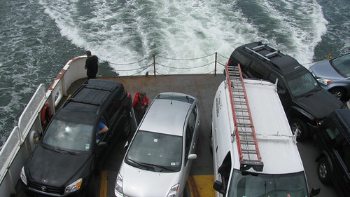
The Bridgeport/ Port Jefferson ferry across Long Island Sound
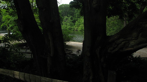
This seemed to be a theme on this trip - trees placed between the road and the water, as if you're being protected from the amazing view.
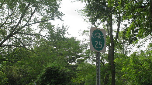
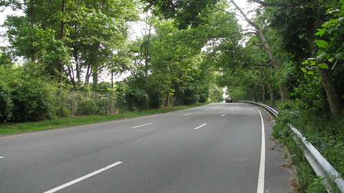
Bike route 25 in Long Island
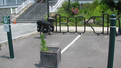
Hildy parked at the Cold Spring Harbor library
25A across Hempstead Harbor. I booked across the bridge as quickly as I could, then walked the bike up the hill (walking in the grass). I then got the hell off 25A as quickly as I could.
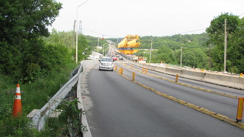
Long Island Expressway service road. Not much of a shoulder, but traffic was very light.
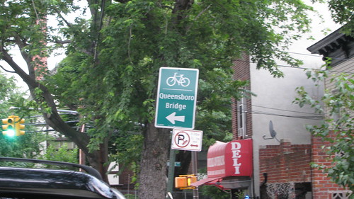
These signs are all over Queens on bike-friendly streets. Cool!
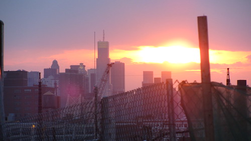
My first sighting of the New York City skyline, on Skillman in Queens, a few miles from the Queensboro Bridge
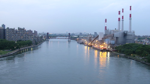
The East River, seen from the Queensboro Bridge. Queens is on the right, Manhattan on the left.
a quickr pickr post
The Bridgeport/ Port Jefferson ferry across Long Island Sound
This seemed to be a theme on this trip - trees placed between the road and the water, as if you're being protected from the amazing view.
Bike route 25 in Long Island
Hildy parked at the Cold Spring Harbor library
25A across Hempstead Harbor. I booked across the bridge as quickly as I could, then walked the bike up the hill (walking in the grass). I then got the hell off 25A as quickly as I could.
Long Island Expressway service road. Not much of a shoulder, but traffic was very light.
These signs are all over Queens on bike-friendly streets. Cool!
My first sighting of the New York City skyline, on Skillman in Queens, a few miles from the Queensboro Bridge
The East River, seen from the Queensboro Bridge. Queens is on the right, Manhattan on the left.
a quickr pickr post
__________________
Tour Journals, Blog, ride pix
My bands:
Tour Journals, Blog, ride pix
My bands:
- Uke On! - ukulele duo - Videos
- Ukulele Abyss - ukulele cover videos - Videos
- Baroque and Hungry's (Celtic fusion) full-length studio album Mended.
- Artistic Differences - 8-track EP Dreams of Bile and Blood.
05-31-10, 11:13 AM
#24
Senior Member
Neil: So sorry you didn't ask about 25A in Roslyn. I never would have sent you over that bridge - and in fact, could have given you a workaround.
Regarding the problem around CitiField, I'm trying to figure out where the cues got messed up. Someone else said the little dirt path off the Northern Blvd Bridge was still open, so you should have actually exited Northern Blvd BEFORE CitiField. That would have taken you onto the Flushing Bay Promenade and you would have bypassed that whole piece of the trip. What happened?
Regarding the problem around CitiField, I'm trying to figure out where the cues got messed up. Someone else said the little dirt path off the Northern Blvd Bridge was still open, so you should have actually exited Northern Blvd BEFORE CitiField. That would have taken you onto the Flushing Bay Promenade and you would have bypassed that whole piece of the trip. What happened?
05-31-10, 12:30 PM
#25
Senior Member
Thread Starter
Join Date: May 2007
Location: Highland Park, NJ, USA
Posts: 3,798
Bikes: "Hildy", a Novara Randonee touring bike; a 16-speed Bike Friday Tikit; and a Specialized Stumpjumper frame-based built-up MTB, now serving as the kid-carrier, grocery-getter.
Mentioned: 0 Post(s)
Tagged: 0 Thread(s)
Quoted: 11 Post(s)
Likes: 0
Liked 1 Time
in
1 Post
No worries about 25A. I too a risk, and it didn't pan out. 25a is a decent rod for biking until that point, though.
I wasn't able to find the Flushing Bay Promenade. I did see a path along the water, so I took that, upon reflection for too far. I had my GPS search for the 82nd St/ Ditmars intersection, but it was a few miles in the wrong direction at that point. I ended up on Roosevelt, quickly transferring over to the 34 ave bike lane. From there, I followed signs to the Queensboro bridge.
I wasn't able to find the Flushing Bay Promenade. I did see a path along the water, so I took that, upon reflection for too far. I had my GPS search for the 82nd St/ Ditmars intersection, but it was a few miles in the wrong direction at that point. I ended up on Roosevelt, quickly transferring over to the 34 ave bike lane. From there, I followed signs to the Queensboro bridge.
__________________
Tour Journals, Blog, ride pix
My bands:
Tour Journals, Blog, ride pix
My bands:
- Uke On! - ukulele duo - Videos
- Ukulele Abyss - ukulele cover videos - Videos
- Baroque and Hungry's (Celtic fusion) full-length studio album Mended.
- Artistic Differences - 8-track EP Dreams of Bile and Blood.