


Share your favorite NorCaL / Bay Area Bike Route.
 04-15-09, 12:36 AM
#1
Banned
Thread Starter
Join Date: Jun 2008
Location: Bay Area, CA
Posts: 343
Bikes: Specialized Tarmac S-Works '06
Mentioned: 0 Post(s)
Tagged: 0 Thread(s)
Quoted: 0 Post(s)
Likes: 0
Liked 0 Times
in
0 Posts
Share your favorite NorCaL / Bay Area Bike Route.
I pretty much keep my rides local around the Castro Valley/pleasanton/livermore area. I do drive up to Martinez sometimes as well, they got some nice abandoned roads where cars aren't allowed  . I think most of you guys probably have the garmin edge or something and perhaps go to different web sites to share your favorite route. I plan to get the garmin edge soon though
  . Currently this is my second favorite route below. I actually found this route online on some web site. I have not completed the route yet, I usually just turn back and only end up doing 35-40 miles. This thread could serve as a nice reference for those unfamiliar with the area, or perhaps just want to try something new I suppose.
Time:3.5-4.5 hrs.
Distance:60.89 mi.
Difficulty:Moderate-Hard
Climbing:4922 ft.
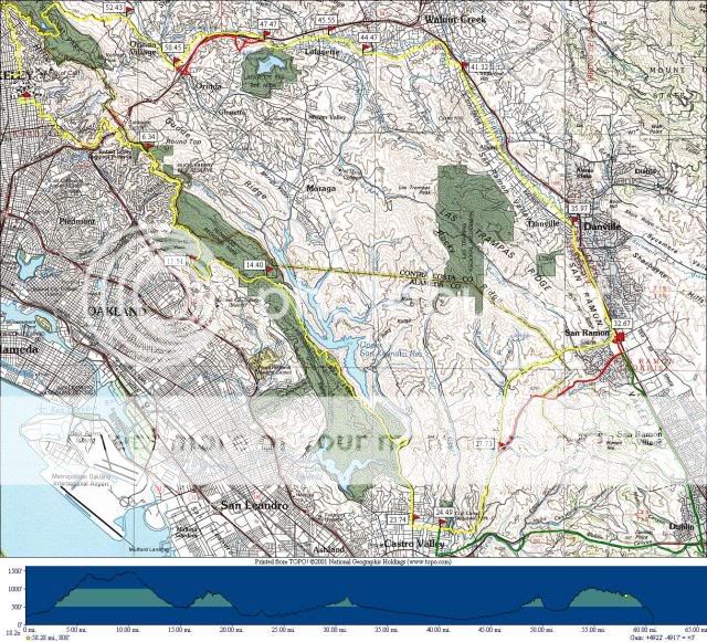
Mile 0.0 - Sproul Plaza to Tunnel Road.
Mile 6.34 - Skyline and Grizzly Peak. Continue straight on Skyline past Grizzly Peak.
Mile 11.51 - Turn left at light on Joaquin Miller.
Mile 12.11 - Turn left on Redwood Rd. There is a long gradual descent into the forest.
Mile 14.40 - Go past the intersection with Pinehurst. This is where the fruit stand ride diverges from most rides that start with Redwood. The next climb is deserted, and the descent is no brakes but not straight either.
Mile 23.74 - You will eventually go over a small hump into Castro Valley. Turn left on Heyer Ave.
Mile 24.49 - Go straight past Center St. up the steep hill.
Alternative Route (in green): Turn right for the longer Dublin Canyon route. Then turn left on Castro Valley Rd. which eventually becomes Dublin Canyon. Once in Pleasanton, turn left on Foothill Blvd. to eventually rejoin the ride.
Mile 24.78 - Turn right on Cull Canyon Rd.
Mile 24.93 - Tricky left onto Crow Canyon Rd. Move over well in advance. Crow Canyon is a nice road except for the cars and the mess on the shoulder. This road is definitely single file.
Mile 27.73 - Go straight past Norris Canyon Rd. or...
Alternative Route (in red): Bear right onto Norris Canyon Rd. for a nice climb and fast descent. Rejoin the route at San Ramon Valley.
Mile 32.67 - Fruit stand! We stop here for food then head left on San Ramon Valley for the flat portion of the ride.
Mile 35.97 - Bear left on Hartz through the center of Danville.
Mile 41.05 - At the end of the long straight section, head straight at the light (instead of turning right under the freeway).
Mile 41.32 - Turn left on Castle Hill Rd.
Mile 41.60 - Turn right on Lilac Dr. This is an easy turn to miss.
Mile 42.27 - Turn left on Newell Ave.
Mile 42.95 - Turn left on Olympic Blvd. This should look familiar as rides often come out this way. Olympic Blvd. is the bar in the dumbell of many longer rides, so there are many ways back from here. Everyone has a favorite.
Mile 44.47 - When you reach the T-intersection, go straight onto the bike path.
Mile 44.87 - Turn right off the bike path at the first opportunity, then left onto Olympic Blvd.
Mile 45.55 - Turn right on Second St. then left ahead on Mt. Diablo Blvd. The ride through Lafayette sucks.
Mile 47.47 - Bear right onto El Nido Ranch Rd. for the Orindawoods return. This small climb can be the test of truth at the end of an epic ride.
Alternative Route (in red): - Keep going straight for a variation called Bike Path. Surprisingly enough, it follows the bike path along 24.
Mile 49.26 - After a short steep pitch, turn left onto Orindawoods Dr. for the descent into Ordina.
Mile 50.45 - Turn right onto El Camino Pablo.
Mile 52.43 - Turn left on Wildcat Canyon for the climb back to Berkeley. This is another killer at the end of a long day.
Mile 58.28 - Head left at the 5-way intersection to descend via Euclid.
. I think most of you guys probably have the garmin edge or something and perhaps go to different web sites to share your favorite route. I plan to get the garmin edge soon though . Currently this is my second favorite route below. I actually found this route online on some web site. I have not completed the route yet, I usually just turn back and only end up doing 35-40 miles. This thread could serve as a nice reference for those unfamiliar with the area, or perhaps just want to try something new I suppose.Time:3.5-4.5 hrs.
Distance:60.89 mi.
Difficulty:Moderate-Hard
Climbing:4922 ft.
Mile 0.0 - Sproul Plaza to Tunnel Road.
Mile 6.34 - Skyline and Grizzly Peak. Continue straight on Skyline past Grizzly Peak.
Mile 11.51 - Turn left at light on Joaquin Miller.
Mile 12.11 - Turn left on Redwood Rd. There is a long gradual descent into the forest.
Mile 14.40 - Go past the intersection with Pinehurst. This is where the fruit stand ride diverges from most rides that start with Redwood. The next climb is deserted, and the descent is no brakes but not straight either.
Mile 23.74 - You will eventually go over a small hump into Castro Valley. Turn left on Heyer Ave.
Mile 24.49 - Go straight past Center St. up the steep hill.
Alternative Route (in green): Turn right for the longer Dublin Canyon route. Then turn left on Castro Valley Rd. which eventually becomes Dublin Canyon. Once in Pleasanton, turn left on Foothill Blvd. to eventually rejoin the ride.
Mile 24.78 - Turn right on Cull Canyon Rd.
Mile 24.93 - Tricky left onto Crow Canyon Rd. Move over well in advance. Crow Canyon is a nice road except for the cars and the mess on the shoulder. This road is definitely single file.
Mile 27.73 - Go straight past Norris Canyon Rd. or...
Alternative Route (in red): Bear right onto Norris Canyon Rd. for a nice climb and fast descent. Rejoin the route at San Ramon Valley.
Mile 32.67 - Fruit stand! We stop here for food then head left on San Ramon Valley for the flat portion of the ride.
Mile 35.97 - Bear left on Hartz through the center of Danville.
Mile 41.05 - At the end of the long straight section, head straight at the light (instead of turning right under the freeway).
Mile 41.32 - Turn left on Castle Hill Rd.
Mile 41.60 - Turn right on Lilac Dr. This is an easy turn to miss.
Mile 42.27 - Turn left on Newell Ave.
Mile 42.95 - Turn left on Olympic Blvd. This should look familiar as rides often come out this way. Olympic Blvd. is the bar in the dumbell of many longer rides, so there are many ways back from here. Everyone has a favorite.
Mile 44.47 - When you reach the T-intersection, go straight onto the bike path.
Mile 44.87 - Turn right off the bike path at the first opportunity, then left onto Olympic Blvd.
Mile 45.55 - Turn right on Second St. then left ahead on Mt. Diablo Blvd. The ride through Lafayette sucks.
Mile 47.47 - Bear right onto El Nido Ranch Rd. for the Orindawoods return. This small climb can be the test of truth at the end of an epic ride.
Alternative Route (in red): - Keep going straight for a variation called Bike Path. Surprisingly enough, it follows the bike path along 24.
Mile 49.26 - After a short steep pitch, turn left onto Orindawoods Dr. for the descent into Ordina.
Mile 50.45 - Turn right onto El Camino Pablo.
Mile 52.43 - Turn left on Wildcat Canyon for the climb back to Berkeley. This is another killer at the end of a long day.
Mile 58.28 - Head left at the 5-way intersection to descend via Euclid.
 04-15-09, 08:10 AM
#2
Senior Member
Join Date: Jan 2007
Location: NorCal
Posts: 1,695
Bikes: Kestrel Talon
Mentioned: 0 Post(s)
Tagged: 0 Thread(s)
Quoted: 0 Post(s)
Likes: 0
Liked 0 Times
in
0 Posts
For kicks, that's also a nice route going clockwise.
My favorite is still Mt. Diablo/Morgan Territory. No fancy directions here, but from San Ramon:
head out Crow Canyon towards the mountain (not sure if you're heading in the right direction? Look up.) The road becomes Blackhawk after crossing Tassajara.
Right turn onto Mt. Diablo Scenic Blvd at stop sign (Athenian school on right) - follow up to the junction with the North Gate Rd.
turn right at stop sign follow up to summit. Rest and enjoy the view. Bathrooms and water available here and at the junction. Turn around and descend.
Bear right at junction Follow Northgate road out of park and to stop sign.
Right at stop sign (Oakgrove Road?). Straight through traffic circle and follow to Ygnacio.
Right on Ygnacio. You'll get a couple of blocks of no shoulder, then there's a wide shoulder the rest of the way. Up and over the hill into Clayton. Stay on Ygnacio to Clayton Blvd.
Right on Clayton Blvd. Peet's on right is a good spot for water, bathrooms, coffee. Stay on Clayton, eventually becomes Marsh Creek. Follow over hill that is longer than it looks, after you loose the shoulder on Marsh Creek (you'll know you're on this hill when you get about half way up and realize that it kind of keeps going") ). At the bottom of the next descent is the right turn onto Morgan Territory.
). At the bottom of the next descent is the right turn onto Morgan Territory.
Follow Morgan Territory for ~ 8 miles up to Morgan Territory regional park parking lot. Bathrooms and water. Recover from climb and get ready for the plunge.
continue on Morgan Territory. The pavement will be much improved at this point, but still single lane. Fast descent, single lane road means you have to be very cautious around blind corners. Can be tricky in cross winds (which is pretty much all the time). Follow to stop sign.
Right on Manning. You'll generally be fighting headwinds now.
Right on Highland. Continue to fight headwinds.
Right on Tassajara.
Left on Crow Canyon.
This is about 70 miles, with ~ 6,000 feet of climbing. These are actually the first 2 climbs of the Devil Mountain Double (coming up this weekend) and you can follow the DMD arrows spray painted on the road until you get to Manning (the DMD goes left at that point over towards the Altamont pass and the next climb). This will take you through downtown Clayton and away from the traffic on the Ygnacio/Clayton Rd intersection, but is otherwise the same route I outlined above.
Variations include only going to the junction on Mt. D. to eliminate some climbing, starting in Danville and approaching the Athenian School from the other direction, using the hole in the wall at the base of the Southgate to avoid the crappy road on Mt. Diablo Scenic, using bike paths from the Northgate to avoid the no shoulder part of Ygnacio (lots of foks on that path, though, so honestly it's not that much better), and starting at Pleasant Hill BART & doing Morgan Territory first.
JB
My favorite is still Mt. Diablo/Morgan Territory. No fancy directions here, but from San Ramon:
head out Crow Canyon towards the mountain (not sure if you're heading in the right direction? Look up.) The road becomes Blackhawk after crossing Tassajara.
Right turn onto Mt. Diablo Scenic Blvd at stop sign (Athenian school on right) - follow up to the junction with the North Gate Rd.
turn right at stop sign follow up to summit. Rest and enjoy the view. Bathrooms and water available here and at the junction. Turn around and descend.
Bear right at junction Follow Northgate road out of park and to stop sign.
Right at stop sign (Oakgrove Road?). Straight through traffic circle and follow to Ygnacio.
Right on Ygnacio. You'll get a couple of blocks of no shoulder, then there's a wide shoulder the rest of the way. Up and over the hill into Clayton. Stay on Ygnacio to Clayton Blvd.
Right on Clayton Blvd. Peet's on right is a good spot for water, bathrooms, coffee. Stay on Clayton, eventually becomes Marsh Creek. Follow over hill that is longer than it looks, after you loose the shoulder on Marsh Creek (you'll know you're on this hill when you get about half way up and realize that it kind of keeps going
). At the bottom of the next descent is the right turn onto Morgan Territory.Follow Morgan Territory for ~ 8 miles up to Morgan Territory regional park parking lot. Bathrooms and water. Recover from climb and get ready for the plunge.
continue on Morgan Territory. The pavement will be much improved at this point, but still single lane. Fast descent, single lane road means you have to be very cautious around blind corners. Can be tricky in cross winds (which is pretty much all the time). Follow to stop sign.
Right on Manning. You'll generally be fighting headwinds now.
Right on Highland. Continue to fight headwinds.
Right on Tassajara.
Left on Crow Canyon.
This is about 70 miles, with ~ 6,000 feet of climbing. These are actually the first 2 climbs of the Devil Mountain Double (coming up this weekend) and you can follow the DMD arrows spray painted on the road until you get to Manning (the DMD goes left at that point over towards the Altamont pass and the next climb). This will take you through downtown Clayton and away from the traffic on the Ygnacio/Clayton Rd intersection, but is otherwise the same route I outlined above.
Variations include only going to the junction on Mt. D. to eliminate some climbing, starting in Danville and approaching the Athenian School from the other direction, using the hole in the wall at the base of the Southgate to avoid the crappy road on Mt. Diablo Scenic, using bike paths from the Northgate to avoid the no shoulder part of Ygnacio (lots of foks on that path, though, so honestly it's not that much better), and starting at Pleasant Hill BART & doing Morgan Territory first.
JB
Last edited by jonathanb715; 04-15-09 at 12:30 PM.
04-15-09, 10:58 AM
#3
Senior Member
Join Date: Apr 2005
Location: Northern California
Posts: 10,879
Mentioned: 2 Post(s)
Tagged: 0 Thread(s)
Quoted: 104 Post(s)
Likes: 0
Liked 5 Times
in
5 Posts
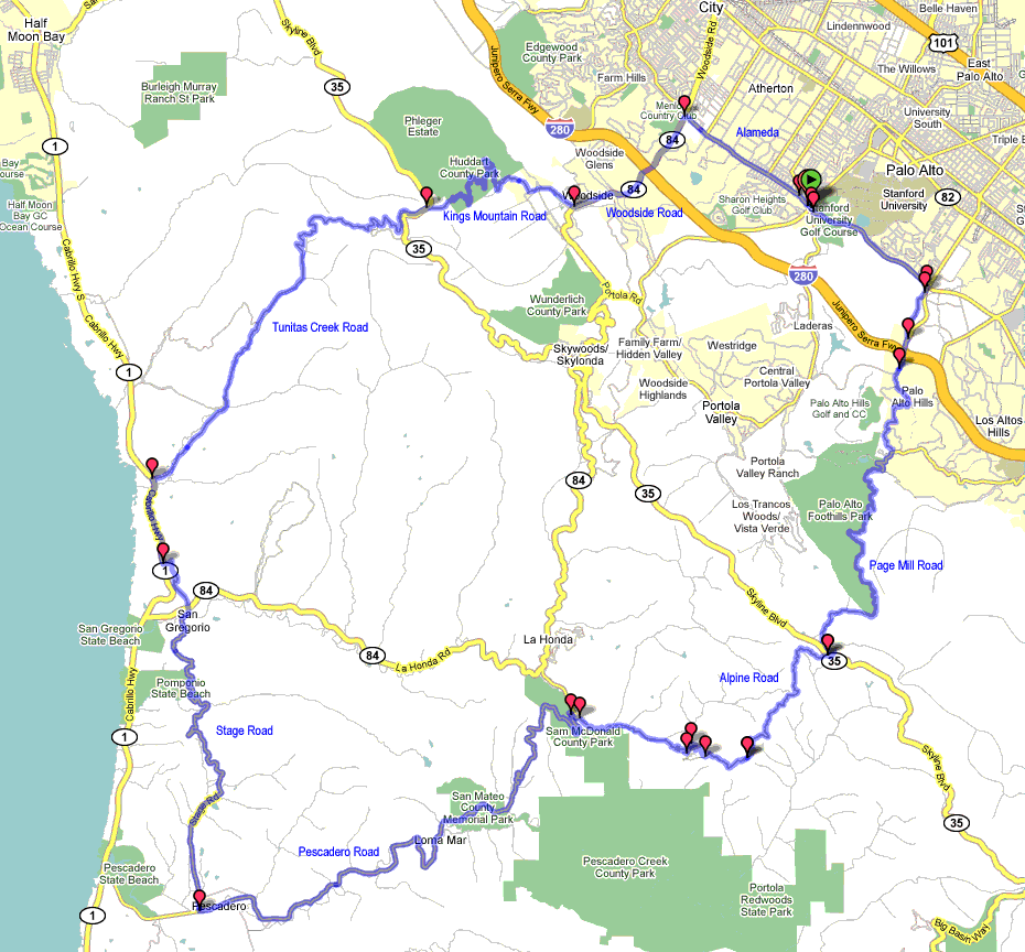
Page Mill Road and Tunitas Creek Road
Here is my favorite local bike ride.
Start at Stanford University (near the upper right of the map).
Climb Page Mill Road to Skyline.
Descend Alpine Road and Pescadero Road to Pescadero.
Food, water, and toilets at the cafe in Pescadero.
North on Old Stage Road.
Climb Tunitas Creek Road to Skyline.
Descend Kings Mountain Road and Woodside Road.
Back to Stanford on Alameda de las Pulgas.
60 miles and 6000 feet of climbing.
Great views. Great climbs. Mostly very light traffic.
Last edited by johnny99; 04-15-09 at 11:02 AM.
04-15-09, 12:34 PM
#4
Senior Member
Join Date: Jan 2007
Location: NorCal
Posts: 1,695
Bikes: Kestrel Talon
Mentioned: 0 Post(s)
Tagged: 0 Thread(s)
Quoted: 0 Post(s)
Likes: 0
Liked 0 Times
in
0 Posts
Here is my favorite local bike ride.
Start at Stanford University (near the upper right of the map).
Climb Page Mill Road to Skyline.
Descend Alpine Road and Pescadero Road to Pescadero.
Food, water, and toilets at the cafe in Pescadero.
North on Old Stage Road.
Climb Tunitas Creek Road to Skyline.
Descend Kings Mountain Road and Woodside Road.
Back to Stanford on Alameda de las Pulgas.
60 miles and 6000 feet of climbing.
Great views. Great climbs. Mostly very light traffic.
Start at Stanford University (near the upper right of the map).
Climb Page Mill Road to Skyline.
Descend Alpine Road and Pescadero Road to Pescadero.
Food, water, and toilets at the cafe in Pescadero.
North on Old Stage Road.
Climb Tunitas Creek Road to Skyline.
Descend Kings Mountain Road and Woodside Road.
Back to Stanford on Alameda de las Pulgas.
60 miles and 6000 feet of climbing.
Great views. Great climbs. Mostly very light traffic.
JB
04-15-09, 04:47 PM
#5
Junior Member
Join Date: May 2008
Location: city by the bay
Posts: 6
Mentioned: 0 Post(s)
Tagged: 0 Thread(s)
Quoted: 0 Post(s)
Likes: 0
Liked 0 Times
in
0 Posts
Mine is easier but this is my go to ride:
https://www.mapmyride.com/ride/united...23810547736596
45 miles with a couple small hills.
https://www.mapmyride.com/ride/united...23810547736596
45 miles with a couple small hills.
04-15-09, 05:04 PM
#6
Senior Member
Join Date: Apr 2005
Location: Northern California
Posts: 10,879
Mentioned: 2 Post(s)
Tagged: 0 Thread(s)
Quoted: 104 Post(s)
Likes: 0
Liked 5 Times
in
5 Posts
Mine is easier but this is my go to ride:
https://www.mapmyride.com/ride/united...23810547736596
45 miles with a couple small hills.
https://www.mapmyride.com/ride/united...23810547736596
45 miles with a couple small hills.
04-15-09, 05:25 PM
#7
Senior Member

Join Date: Sep 2006
Posts: 673
Mentioned: 0 Post(s)
Tagged: 0 Thread(s)
Quoted: 0 Post(s)
Likes: 0
Liked 0 Times
in
0 Posts
Mine is easier but this is my go to ride:
https://www.mapmyride.com/ride/united...23810547736596
45 miles with a couple small hills.
https://www.mapmyride.com/ride/united...23810547736596
45 miles with a couple small hills.
 04-15-09, 05:39 PM
#8
Tandem Mountain Climber
Join Date: Mar 2007
Location: San Mateo, CA
Posts: 4,104
Bikes: Calfee Tandem, Litespeed Gravel, SuperSix Evo HM, Larry vs. Harry Bullitt (e-cargo)
Mentioned: 0 Post(s)
Tagged: 0 Thread(s)
Quoted: 1 Post(s)
Likes: 0
Liked 3 Times
in
1 Post
Here is my favorite local bike ride.
Start at Stanford University (near the upper right of the map).
Climb Page Mill Road to Skyline.
Descend Alpine Road and Pescadero Road to Pescadero.
Food, water, and toilets at the cafe in Pescadero.
North on Old Stage Road.
Climb Tunitas Creek Road to Skyline.
Descend Kings Mountain Road and Woodside Road.
Back to Stanford on Alameda de las Pulgas.
60 miles and 6000 feet of climbing.
Great views. Great climbs. Mostly very light traffic.
https://i203.photobucket.com/albums/a...unitascopy.gif
I also like the Diablo/Morgan ride but is a bit far for me to do frequently.
04-15-09, 06:01 PM
#9
Member
Join Date: Jun 2008
Posts: 36
Bikes: Specialized Sequoia
Mentioned: 0 Post(s)
Tagged: 0 Thread(s)
Quoted: 0 Post(s)
Likes: 0
Liked 0 Times
in
0 Posts
The paradise rounte a great route. I did it a few weeks ago. Keep the routes coming. Since I recently moved to the bay area (about a year), I still haven't found all the good routes. Does anyone have any more that leave from the city or are down the pennisula?
04-15-09, 07:40 PM
#10
RacingBear

 The best part of fruit stand ride is a stop at fruit stand for some munchies! he he.
04-15-09, 09:27 PM
The best part of fruit stand ride is a stop at fruit stand for some munchies! he he.
04-15-09, 09:27 PM
#12

crazy bike girl

Join Date: Jul 2007
Location: CA Central Coast
Posts: 3,325
Bikes: '07 Orbea Onix, '07 Birdy Yellow, '06 Cannondale Bad Boy (stolen)
Mentioned: 0 Post(s)
Tagged: 0 Thread(s)
Quoted: 0 Post(s)
Likes: 0
Liked 3 Times
in
3 Posts
+1
__________________
Countries I've ridden in: US, Canada, Ireland, UK, Germany, Netherlands, France, China, Singapore, Malaysia
States I've ridden in: Illinois, Connecticut, Massachusetts, Pennsylvania, California, Nevada, Missouri, Colorado
Countries I've ridden in: US, Canada, Ireland, UK, Germany, Netherlands, France, China, Singapore, Malaysia
States I've ridden in: Illinois, Connecticut, Massachusetts, Pennsylvania, California, Nevada, Missouri, Colorado
04-15-09, 09:46 PM
#13
Spinning like a gerbel

Join Date: Jul 2005
Location: Silicon Valley
Posts: 7,960
Bikes: Seven
Mentioned: 1 Post(s)
Tagged: 0 Thread(s)
Quoted: 2 Post(s)
Likes: 0
Liked 4 Times
in
2 Posts
I like the "recovery ride" we did Sunday, up OLH, down 84, up Alpine. Nice way to get in a quick 40 miles.
04-15-09, 10:03 PM
#14
moth -----> flame

Join Date: Dec 2007
Location: SF Bay Area
Posts: 5,916
Bikes: 11 CAAD 10-4, 07 Specialized Roubaix Comp, 98 Peugeot Horizon
Mentioned: 0 Post(s)
Tagged: 0 Thread(s)
Quoted: 1 Post(s)
Likes: 0
Liked 2 Times
in
2 Posts
Agree with uspspro - Diablo is an awesome ride and my favourite descent in the bay area (so far). More locally, the Pinehurst/Redwood loop is just a beautiful ride.
__________________
BF, in a nutshell
BF, in a nutshell
04-15-09, 10:08 PM
#15
Banned
Thread Starter
Join Date: Jun 2008
Location: Bay Area, CA
Posts: 343
Bikes: Specialized Tarmac S-Works '06
Mentioned: 0 Post(s)
Tagged: 0 Thread(s)
Quoted: 0 Post(s)
Likes: 0
Liked 0 Times
in
0 Posts
04-15-09, 10:09 PM
#16

phony collective progress

Join Date: Sep 2006
Location: San Hoosey
Posts: 2,973
Bikes: https://velospace.org/user/36663
Mentioned: 0 Post(s)
Tagged: 0 Thread(s)
Quoted: 0 Post(s)
Likes: 0
Liked 4 Times
in
3 Posts
OLH - 84 - (mini) Stage - 1 - Tunitas - Kings is my favorite default loop, though I enjoyed adding Pescadero and the rest of Stage last time I did it.
The OLH - 84 - Alpine - Page Mill loop on Sunday was great, as well. The combination of the two routes posted by johnny99 above is interesting. I'll have to try that one some time.
If I'm indecisive and don't want to go very far (hey, it's only an hour away, that's close!), going up the North side of Diablo is always welcome.
__________________

04-15-09, 10:10 PM
#17
phony collective progress
Join Date: Sep 2006
Location: San Hoosey
Posts: 2,973
Bikes: https://velospace.org/user/36663
Mentioned: 0 Post(s)
Tagged: 0 Thread(s)
Quoted: 0 Post(s)
Likes: 0
Liked 4 Times
in
3 Posts
Coming down the North side probably isn't too bad if you take it easy. I've only been down the South side a handful of times, but I seem to recall it being a bit mellower than the North.
__________________
04-15-09, 10:27 PM
#18
moth -----> flame
Join Date: Dec 2007
Location: SF Bay Area
Posts: 5,916
Bikes: 11 CAAD 10-4, 07 Specialized Roubaix Comp, 98 Peugeot Horizon
Mentioned: 0 Post(s)
Tagged: 0 Thread(s)
Quoted: 1 Post(s)
Likes: 0
Liked 2 Times
in
2 Posts
I find the toughest part is descending the 3-400ft stretch from the summit because it's so steep; it's tough to slow if you follow a car. Beyond that though, the pavement is good, and the corners aren't too tight. First time down, watch for corners which are preceded by a 15mph sign, those are the ones to take a little slower.
__________________
BF, in a nutshell
BF, in a nutshell
04-16-09, 07:56 AM
#19
Full Member

Join Date: May 2007
Location: SF East Bay
Posts: 448
Bikes: '07 Look 585 Ultra, '07 Trek Madone SL 5.2, '06 Marin Pine Mountain MTB, '23 Trek Emonda SL6 Pro
Mentioned: 0 Post(s)
Tagged: 0 Thread(s)
Quoted: 0 Post(s)
Likes: 0
Liked 0 Times
in
0 Posts
I don't think so, I like it because it's 11miles of unadulterated fun and the amount of 4wheel traffic is often pretty low. If you aren't used to descending 2-3miles I'd consider practice on smaller climbs first, although it's easy to break the descent up into chunks if you wish.
I find the toughest part is descending the 3-400ft stretch from the summit because it's so steep; it's tough to slow if you follow a car. Beyond that though, the pavement is good, and the corners aren't too tight. First time down, watch for corners which are preceded by a 15mph sign, those are the ones to take a little slower.
I find the toughest part is descending the 3-400ft stretch from the summit because it's so steep; it's tough to slow if you follow a car. Beyond that though, the pavement is good, and the corners aren't too tight. First time down, watch for corners which are preceded by a 15mph sign, those are the ones to take a little slower.
https://www.youtube.com/watch?v=gaiSM...rom=PL&index=2
https://www.youtube.com/watch?v=CQgEm...eature=related
Tarmacdude, I found these two clips on the descent from the summit down South Gate Road which should give you an idea of what to expect. And Beaker's right, it can be really fun.
04-16-09, 09:06 AM
#20
moth -----> flame
Join Date: Dec 2007
Location: SF Bay Area
Posts: 5,916
Bikes: 11 CAAD 10-4, 07 Specialized Roubaix Comp, 98 Peugeot Horizon
Mentioned: 0 Post(s)
Tagged: 0 Thread(s)
Quoted: 1 Post(s)
Likes: 0
Liked 2 Times
in
2 Posts
Nice links. That reminds me, Devils elbow (hairpin close to the summit) is probably the toughest corner - tends to be a bit gravelly. I don't normally hit it as quickly as these guys, so in answer to your other question - I rarely get a max of over 40 on Diablo. You could if you wanted to, but to me the fun lies not in the max speeds but in the combination of sweeping corners, smooth road surface and spectacular views. This has been known to make me spontaneously whoop out loud, which is not something I tend to do in the rest of my life.
__________________
BF, in a nutshell
BF, in a nutshell
04-16-09, 04:51 PM
#21
Banned
Thread Starter
Join Date: Jun 2008
Location: Bay Area, CA
Posts: 343
Bikes: Specialized Tarmac S-Works '06
Mentioned: 0 Post(s)
Tagged: 0 Thread(s)
Quoted: 0 Post(s)
Likes: 0
Liked 0 Times
in
0 Posts
https://www.youtube.com/watch?v=gaiSM...rom=PL&index=2
https://www.youtube.com/watch?v=CQgEm...eature=related
Tarmacdude, I found these two clips on the descent from the summit down South Gate Road which should give you an idea of what to expect. And Beaker's right, it can be really fun.
https://www.youtube.com/watch?v=CQgEm...eature=related
Tarmacdude, I found these two clips on the descent from the summit down South Gate Road which should give you an idea of what to expect. And Beaker's right, it can be really fun.
04-16-09, 05:25 PM
#22
Senior Member
Join Date: Jan 2007
Location: NorCal
Posts: 1,695
Bikes: Kestrel Talon
Mentioned: 0 Post(s)
Tagged: 0 Thread(s)
Quoted: 0 Post(s)
Likes: 0
Liked 0 Times
in
0 Posts
That descent looks like a blast, and well worth all the climbing. How fast are you guys going down that descent? I am going to have to train considerably hard to complete that route. Farthest I've gone is 40 miles without a rest break, but I definitely look forward to trying that out in the next couple of months when my conditioning is up to par.
- a car coming up the other way (many times actually, often passing a bicycle on the way up)
- a coyote
- a small rock slide that would hurt (or at least trash your wheels) if you couldn't stop in time
- a flock of turkeys
- hikers
- a park ranger's pickup truck stopped for no apparent reason.
Take it easy - the descent is fun. You don't need to ride your brakes all the way down - just slow down enough for the tighter hairpins so that you have options if something unexpected is waiting just around that corner.
JB
Last edited by jonathanb715; 04-16-09 at 05:33 PM.
04-16-09, 05:27 PM
#23
Full Member
Join Date: May 2007
Location: SF East Bay
Posts: 448
Bikes: '07 Look 585 Ultra, '07 Trek Madone SL 5.2, '06 Marin Pine Mountain MTB, '23 Trek Emonda SL6 Pro
Mentioned: 0 Post(s)
Tagged: 0 Thread(s)
Quoted: 0 Post(s)
Likes: 0
Liked 0 Times
in
0 Posts
That descent looks like a blast, and well worth all the climbing. How fast are you guys going down that descent? I am going to have to train considerably hard to complete that route. Farthest I've gone is 40 miles without a rest break, but I definitely look forward to trying that out in the next couple of months when my conditioning is up to par.
Last edited by alainp; 04-16-09 at 10:40 PM.
04-16-09, 08:17 PM
#24
moth -----> flame
Join Date: Dec 2007
Location: SF Bay Area
Posts: 5,916
Bikes: 11 CAAD 10-4, 07 Specialized Roubaix Comp, 98 Peugeot Horizon
Mentioned: 0 Post(s)
Tagged: 0 Thread(s)
Quoted: 1 Post(s)
Likes: 0
Liked 2 Times
in
2 Posts
That descent looks like a blast, and well worth all the climbing. How fast are you guys going down that descent? I am going to have to train considerably hard to complete that route. Farthest I've gone is 40 miles without a rest break, but I definitely look forward to trying that out in the next couple of months when my conditioning is up to par.
__________________
BF, in a nutshell
BF, in a nutshell
04-17-09, 04:07 PM
#25
sniffin' glue

Join Date: Jul 2007
Location: Seattle
Posts: 3,177
Bikes: Surly crosscheck ssfg, Custom vintage french racing bike, Bruce Gordon Rock & Road
Mentioned: 0 Post(s)
Tagged: 0 Thread(s)
Quoted: 2 Post(s)
Likes: 0
Liked 0 Times
in
0 Posts
Why is the OLH-Tunitas Creek loop always shown clockwise? Is there a particular reason to ride this loop clockwise? I was thinking of heading down there tomorrow. My time in the bay area is coming to a close, and I want to hit up the must ride roads before I go, or at least as many as i can!