


The Mountain Burns :(
 09-09-13, 08:33 AM
#1
Senior Member
Thread Starter
Join Date: Jan 2010
Location: Walnut Creek, CA
Posts: 2,668
Bikes: 2023 Canyon Aeoroad CF SL, 2015 Trek Emonda SLR, 2002 Litespeed Classic, 2005 Bianchi Pista, Some BikesDirect MTB I never ride.
Mentioned: 10 Post(s)
Tagged: 0 Thread(s)
Quoted: 647 Post(s)
Liked 136 Times
in
89 Posts
The Mountain Burns :(
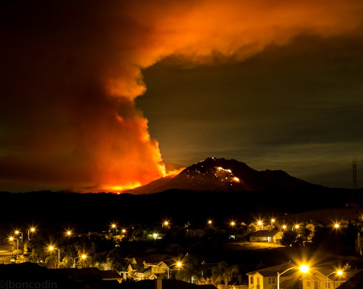
Saw it coming back from my ride yesterday (went west, due to 100+ temps), was hoping it was not Diablo. When I first saw where it was, it looked to be on the north end of the backside of North Peak. The smoke plume got scary big later in the afternoon, and that's when I realized this was not good. This morning, the smoke looks to be coming from south of Diablo's summit! Very sad, hopefully it can be put out without too much damage. I don't see anything yet about road closures yet, but I'm sure it will be coming.
If anyone has news/info/videos/photos of the fire and wants to share it, please post links in here. I saw some decent helicopter footage yesterday on some website, but I'm curious to see what's already burned and where it's headed. Also, any news of road closures and the like, post that as well. This has been a terrible year for fire in California...
If anyone has news/info/videos/photos of the fire and wants to share it, please post links in here. I saw some decent helicopter footage yesterday on some website, but I'm curious to see what's already burned and where it's headed. Also, any news of road closures and the like, post that as well. This has been a terrible year for fire in California...
 09-09-13, 09:03 AM
#2
It's MY mountain

Join Date: Sep 2006
Location: Mt.Diablo
Posts: 10,002
Bikes: Klein, Merckx, Trek
Mentioned: 70 Post(s)
Tagged: 0 Thread(s)
Quoted: 4338 Post(s)
Liked 2,980 Times
in
1,617 Posts
It's the southeast side of the Mountain, but it's putting the structures at the Summit in danger - the communications towers and the visitors center are all at risk but easier to protect than the wilderness areas farther below.
09-09-13, 10:08 AM
#3
It's MY mountain
Join Date: Sep 2006
Location: Mt.Diablo
Posts: 10,002
Bikes: Klein, Merckx, Trek
Mentioned: 70 Post(s)
Tagged: 0 Thread(s)
Quoted: 4338 Post(s)
Liked 2,980 Times
in
1,617 Posts
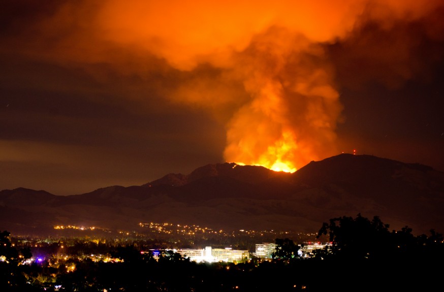
From my office in Walnut Creek just now.

09-09-13, 12:55 PM
#4
Senior Member

Join Date: Nov 2003
Location: Grass Valley, CA
Posts: 2,544
Bikes: Time RXRS, Specialized Stumpjumper FSR
Mentioned: 0 Post(s)
Tagged: 0 Thread(s)
Quoted: 1 Post(s)
Likes: 0
Liked 0 Times
in
0 Posts
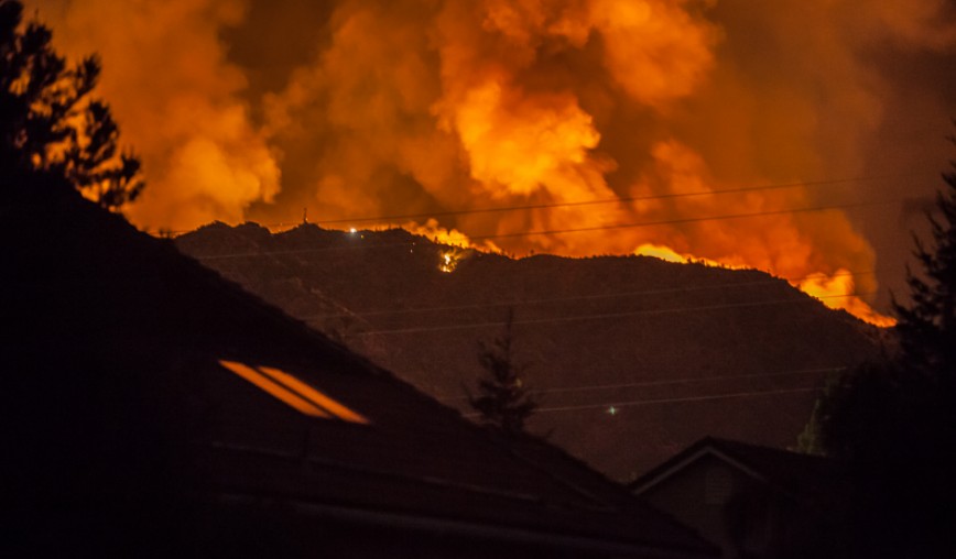
Some last night shots from the other side in Lafayette. The fire reached the North Peak summit and was met by fire fighters to prevent it from jumping to the west side.


Last edited by gpelpel; 09-09-13 at 12:58 PM.
09-09-13, 01:41 PM
#5
Senior Member
Thread Starter
Join Date: Jan 2010
Location: Walnut Creek, CA
Posts: 2,668
Bikes: 2023 Canyon Aeoroad CF SL, 2015 Trek Emonda SLR, 2002 Litespeed Classic, 2005 Bianchi Pista, Some BikesDirect MTB I never ride.
Mentioned: 10 Post(s)
Tagged: 0 Thread(s)
Quoted: 647 Post(s)
Liked 136 Times
in
89 Posts
Wow, scary photos. Looking at Google Earth, if it's burning on the SE side, it should hopefully run out of the heavier fuels (manzanita) and into grasses. To my untrained eye, it looks like if they can control it between the summit, Ransom Point, and Prospectors Gap, that should hopefully keep it from getting out of control on the north/west side of Diablo.
Park is now officially closed to everyone. I know riding it is secondary to getting the fire out, but I hope they can at least open it to the junction within a week or so.
https://www.parks.ca.gov/?page_id=517
Also, per Calfire, MT and MCR are closed as well. The link below is also the incident page for the Morgan Fire, still shows at only 10% containment.
https://cdfdata.fire.ca.gov/incidents...ncident_id=908
Last edited by cthenn; 09-09-13 at 01:44 PM.
09-09-13, 01:59 PM
#6
It's MY mountain
Join Date: Sep 2006
Location: Mt.Diablo
Posts: 10,002
Bikes: Klein, Merckx, Trek
Mentioned: 70 Post(s)
Tagged: 0 Thread(s)
Quoted: 4338 Post(s)
Liked 2,980 Times
in
1,617 Posts
Smoke plume looks significantly smaller than it did this morning... not sure if that means anything.

09-09-13, 02:29 PM
#8
Senior Member
I just saw a DC-10 water bomber circling over Livermore. I'm guessing its been re-directed temporarily from Yosemite fire.
09-09-13, 03:05 PM
#9
Family, Health, Cycling
Cal Fire Live Scanner Feed Online: https://www.broadcastify.com/listen/feed/3798
Listen live to ground crews, helicopters, tanker planes and traffic controllers, pretty riveting.
Listen live to ground crews, helicopters, tanker planes and traffic controllers, pretty riveting.

 09-09-13, 06:51 PM
#11
Senior Member
Thread Starter
Join Date: Jan 2010
Location: Walnut Creek, CA
Posts: 2,668
Bikes: 2023 Canyon Aeoroad CF SL, 2015 Trek Emonda SLR, 2002 Litespeed Classic, 2005 Bianchi Pista, Some BikesDirect MTB I never ride.
Mentioned: 10 Post(s)
Tagged: 0 Thread(s)
Quoted: 647 Post(s)
Liked 136 Times
in
89 Posts
5:45 from my backyard. Wow, they must be getting a pretty good handle on it, I hardly see any smoke?! That would be great news!
I circled the only area I could see smoke. 5% of what it was earlier, though perhaps the wind is blowing away from me and the fire is burning lower.

I circled the only area I could see smoke. 5% of what it was earlier, though perhaps the wind is blowing away from me and the fire is burning lower.
09-09-13, 09:23 PM
#13
Senior Member
Join Date: Nov 2003
Location: Grass Valley, CA
Posts: 2,544
Bikes: Time RXRS, Specialized Stumpjumper FSR
Mentioned: 0 Post(s)
Tagged: 0 Thread(s)
Quoted: 1 Post(s)
Likes: 0
Liked 0 Times
in
0 Posts
From Lafayette we can see some orange popping just to the north-east of the Summit. Not sure if these are flames or smoke lighted by the burning area east of the mountain.
09-10-13, 12:10 AM
#14

Homey

Join Date: Apr 2005
Posts: 13,499
Mentioned: 56 Post(s)
Tagged: 0 Thread(s)
Quoted: 2427 Post(s)
Liked 1,406 Times
in
900 Posts
The embers are setting off new fires. The point of origin is on fire again.
My sister in law was able to get her horses out but they won't let the residents back in to get more animals and their belongings. The horses are in stables with no way to run. Someone mentioned that in the past in other fires they paint phone numbers on the horses and let them loose. But now it's too late. I'm waiting for a call to go help with moving stuff but as of now the roads are blocked and they won't let anyone get up there.
I just got this message sent to me. Not sure which ranch.
Back to the fire on Morgan Territory. Hearing a horse ranch is on fire. Horses might still be there (not confirmed). People are evacuating the area. Stay tuned for more.
09-10-13, 12:16 AM
#15
Homey
Join Date: Apr 2005
Posts: 13,499
Mentioned: 56 Post(s)
Tagged: 0 Thread(s)
Quoted: 2427 Post(s)
Liked 1,406 Times
in
900 Posts
Oh good just got this:
FIRE UPDATE: According to sources, no horses have died. This latest flare-up on Morgan Territory was apparently caused by wind. We have reports of a few buildings being burned. Not sure if they are houses or outbuildings (sheds, etc.). One person on scene says the latest flare-up seems to be under control (cross your fingers).
FIRE UPDATE: According to sources, no horses have died. This latest flare-up on Morgan Territory was apparently caused by wind. We have reports of a few buildings being burned. Not sure if they are houses or outbuildings (sheds, etc.). One person on scene says the latest flare-up seems to be under control (cross your fingers).
 09-10-13, 08:24 AM
#17
Senior Member
Thread Starter
Join Date: Jan 2010
Location: Walnut Creek, CA
Posts: 2,668
Bikes: 2023 Canyon Aeoroad CF SL, 2015 Trek Emonda SLR, 2002 Litespeed Classic, 2005 Bianchi Pista, Some BikesDirect MTB I never ride.
Mentioned: 10 Post(s)
Tagged: 0 Thread(s)
Quoted: 647 Post(s)
Liked 136 Times
in
89 Posts
^^^That's actually a really cool photo.
09-10-13, 12:01 PM
#18

Senior Member
I was going to attempt Mt. Diablo for the first time this Sunday. Looks like that might not happen.
Hopefully everyone remains safe and sound.
Hopefully everyone remains safe and sound.
09-11-13, 10:01 AM
#19
Senior Member
Thread Starter
Join Date: Jan 2010
Location: Walnut Creek, CA
Posts: 2,668
Bikes: 2023 Canyon Aeoroad CF SL, 2015 Trek Emonda SLR, 2002 Litespeed Classic, 2005 Bianchi Pista, Some BikesDirect MTB I never ride.
Mentioned: 10 Post(s)
Tagged: 0 Thread(s)
Quoted: 647 Post(s)
Liked 136 Times
in
89 Posts
So, the Calfire page says "no road closures in effect", but the Mt. Diablo State Parks page still says closed. I called the number, and a prerecorded message still says closed as well. I'm sure it is closed, as the fire is not out yet, and from some pictures I did see, there was damage to some of the picnic areas and signs and such along Summit Rd. I hope this doesn't mean the park will be closed for an extended period once the fire is out, but it looks like it may be a long haul before those of us who enjoy riding the mountain so much can get back up there again. I'm gonna have to find a new weekday ride!
But, if anyone does actually ride up to either gate in the next few days/weeks, let us know what you see, if the gates are closed or if maybe the messages are wrong, and the roads reopen.
But, if anyone does actually ride up to either gate in the next few days/weeks, let us know what you see, if the gates are closed or if maybe the messages are wrong, and the roads reopen.
09-11-13, 10:10 AM
#20
Banned
Join Date: Dec 2010
Location: West Coast of Wisconsin
Posts: 660
Bikes: 2011 Surly LHT 2005 LeMond Zurich
Mentioned: 0 Post(s)
Tagged: 0 Thread(s)
Quoted: 0 Post(s)
Likes: 0
Liked 0 Times
in
0 Posts
Sorry for all of that.
On a lighter note, I thought the thread was a about climbing and quads
On a lighter note, I thought the thread was a about climbing and quads
09-11-13, 04:40 PM
#21
Member

Join Date: Oct 2009
Location: Nor Cal
Posts: 825
Mentioned: 0 Post(s)
Tagged: 0 Thread(s)
Quoted: 0 Post(s)
Liked 0 Times
in
0 Posts
They're forecasting that the fire will be out by Friday. I was hoping to ride The Mountain on Sunday, but sounds like that may not be possible.
Bob
Bob
09-11-13, 05:02 PM
#22
Homey
Join Date: Apr 2005
Posts: 13,499
Mentioned: 56 Post(s)
Tagged: 0 Thread(s)
Quoted: 2427 Post(s)
Liked 1,406 Times
in
900 Posts
Some of the roads are open because they are allowing some residents back in. This was posted last night.
As of 6:30pm, everybody who was evacuation during the Morgan Fire can now go home! Also, all roads are open.
As of 6:30pm, everybody who was evacuation during the Morgan Fire can now go home! Also, all roads are open.
09-12-13, 11:54 AM
#23
Member
Join Date: Oct 2009
Location: Nor Cal
Posts: 825
Mentioned: 0 Post(s)
Tagged: 0 Thread(s)
Quoted: 0 Post(s)
Liked 0 Times
in
0 Posts
From savemountdiablo.org:
Updated: Sep 12, 2013 10:25am
Park Status: The park is still closed, but park officals anticipate a partial opening Monday, September 16th.
Figherfighters have the fire 90% contained and reduced to 3,133 acres. They expect to have it fully contained by Friday. All evaculations and road restrictions have been lifted.
I guess I'll have to pay my respect next weekend.
Bob
09-12-13, 12:36 PM
#24
Crawlin' up, flyin' down

Join Date: Jan 2006
Location: Democratic Peoples' Republic of Berkeley
Posts: 5,653
Bikes: 1967 Paramount; 1982-ish Ron Cooper; 1978 Eisentraut "A"; two mid-1960s Cinelli Speciale Corsas; and others in various stages of non-rideability.
Mentioned: 40 Post(s)
Tagged: 0 Thread(s)
Quoted: 1025 Post(s)
Liked 2,525 Times
in
1,055 Posts
The silver lining to the cloud: the word is that this coming spring and one or two beyond that will be spectacular for wildflowers in the affected areas.
https://www.sfgate.com/bayarea/articl...re-4807527.php
We can't undo the fire, so we may as well at least enjoy the display.
https://www.sfgate.com/bayarea/articl...re-4807527.php
We can't undo the fire, so we may as well at least enjoy the display.
__________________
"I'm in shape -- round is a shape." Andy Rooney
"I'm in shape -- round is a shape." Andy Rooney
 09-12-13, 02:16 PM
#25
It's MY mountain
Join Date: Sep 2006
Location: Mt.Diablo
Posts: 10,002
Bikes: Klein, Merckx, Trek
Mentioned: 70 Post(s)
Tagged: 0 Thread(s)
Quoted: 4338 Post(s)
Liked 2,980 Times
in
1,617 Posts
The silver lining to the cloud: the word is that this coming spring and one or two beyond that will be spectacular for wildflowers in the affected areas.
https://www.sfgate.com/bayarea/articl...re-4807527.php
We can't undo the fire, so we may as well at least enjoy the display.
https://www.sfgate.com/bayarea/articl...re-4807527.php
We can't undo the fire, so we may as well at least enjoy the display.
Yeah, brown lining... more motor vehicles. I'm thinking there will be a lot of fire damage looky-loos the first few weeks the Park is back open too.