


Graphs and numbers guys..I need some help..
 02-21-09, 12:13 PM
#1
Senior Member
Thread Starter
Join Date: Sep 2008
Location: Phoenix
Posts: 856
Bikes: Felt F4
Mentioned: 0 Post(s)
Tagged: 0 Thread(s)
Quoted: 0 Post(s)
Likes: 0
Liked 0 Times
in
0 Posts
Graphs and numbers guys..I need some help..
My brother wants me to come out to Portland for some suicide ride, only problem is the ride has a bunch of hills and I live in flat ass AZ so I don't know how to train for it.
There is one challenging hill by my house, here is the link:
https://www.roadbikerides.com/ride/view/usery_pass/190
And this is one of the routes my brother is doing to train:
https://trail.motionbased.com/trail/i...kValue=7549991
Sooo..I don't really know how to read these numbers..I guess what I want to know is if there is any way I can use my one hill to match the training that he's doing, like can I loop it a couple times or something? Or am I just screwed?
 02-21-09, 12:47 PM
#2

Uber Goober

On your first graph, it shows a variation of over 700' but shows ascent as 312', which is obviously off. I'm not sure what's going on there. But that looks like a pretty substantial training route to me. The second one won't open without having an account.
We lived in Colorado for several years, and I got pretty good at hiking in the mountains. But a part of it is hard to duplicate without being there. For example, going up and down a 10' flight of stairs a 100 times is not the same as hiking 1,000' up. So to a certain extent, you're just screwed if you're expecting to perform the same as someone that rides that same route all the time. And you'll see all these pros going to the Andes or the Alps or wherever to train- they don't stay in Bugtussle and ride the same hill a hundred times. But that doesn't mean you can't make the route, or that you shouldn't ride it.
We lived in Colorado for several years, and I got pretty good at hiking in the mountains. But a part of it is hard to duplicate without being there. For example, going up and down a 10' flight of stairs a 100 times is not the same as hiking 1,000' up. So to a certain extent, you're just screwed if you're expecting to perform the same as someone that rides that same route all the time. And you'll see all these pros going to the Andes or the Alps or wherever to train- they don't stay in Bugtussle and ride the same hill a hundred times. But that doesn't mean you can't make the route, or that you shouldn't ride it.
__________________
"be careful this rando stuff is addictive and dan's the 'pusher'."
"be careful this rando stuff is addictive and dan's the 'pusher'."
02-21-09, 01:03 PM
#3
Senior Member
Join Date: Oct 2008
Location: Phoenix
Posts: 115
Bikes: Scott CR-1 SL, Scott Plasma TT
Mentioned: 0 Post(s)
Tagged: 0 Thread(s)
Quoted: 0 Post(s)
Likes: 0
Liked 0 Times
in
0 Posts
Dude you're starting off Brown. Forget Usery. Ride east to Apache Trail (88) and ride it past Tortilla Flats to where the pavement ends. Repeat as necessary.
IIRC, where Brown joins 88 to the end and back is about 40miles and 4000' total vert. Probably 55-60 miles round trip from where you are starting.
IIRC, where Brown joins 88 to the end and back is about 40miles and 4000' total vert. Probably 55-60 miles round trip from where you are starting.
02-21-09, 05:31 PM
#4
Senior Member
Thread Starter
Join Date: Sep 2008
Location: Phoenix
Posts: 856
Bikes: Felt F4
Mentioned: 0 Post(s)
Tagged: 0 Thread(s)
Quoted: 0 Post(s)
Likes: 0
Liked 0 Times
in
0 Posts
Grom thanks man, hey I actually start on southern and val vista, is there a map of that route somewhere that I can check out? I'm not too familiar with the area out here..
02-21-09, 05:50 PM
#5
Senior Member
Join Date: Apr 2007
Posts: 374
Mentioned: 0 Post(s)
Tagged: 0 Thread(s)
Quoted: 0 Post(s)
Likes: 0
Liked 0 Times
in
0 Posts
do the some riding up in paradise valley around camelback. that and somo- south mountain is about 6 miles to the top, with the last qtr mile shooting pretty steep. if you do a couple reps of it, and ride to and from that would be a solid ride. I second the suggestion to do the tortilla flats ride though, only problem is it can be a pain when there is boat traffic (any day above 70 degrees) so your windows running out
02-21-09, 05:56 PM
#6

Senior Member

Dude you're starting off Brown. Forget Usery. Ride east to Apache Trail (88) and ride it past Tortilla Flats to where the pavement ends. Repeat as necessary.
IIRC, where Brown joins 88 to the end and back is about 40miles and 4000' total vert. Probably 55-60 miles round trip from where you are starting.
IIRC, where Brown joins 88 to the end and back is about 40miles and 4000' total vert. Probably 55-60 miles round trip from where you are starting.
Amazing route.
__________________
BMC Roadmachine
Kona Jake the Snake
BMC Roadmachine
Kona Jake the Snake
02-21-09, 07:19 PM
#7
moth -----> flame

Join Date: Dec 2007
Location: SF Bay Area
Posts: 5,916
Bikes: 11 CAAD 10-4, 07 Specialized Roubaix Comp, 98 Peugeot Horizon
Mentioned: 0 Post(s)
Tagged: 0 Thread(s)
Quoted: 1 Post(s)
Likes: 0
Liked 2 Times
in
2 Posts
In answer to your original question, yes you should be able to compare graphs to help you train for a ride. Your route seems to climb 7-800ft in ~3.5miles (~4.3% for 800ft), whereas your brother's route looks steeper climbing 550-600ft in ~1.5miles (7.6% for 600ft). It'll help if you can compare your route with the profile of the ride you're going to do - do you need to work on long climbs/endurance, or is it how to get up shorter, but steeper climbs?
If you're training for moderately steeper climbs perhaps you could use your local route and just try getting used to climbing it one cog over on your cassette compared to normal and see how that works. For me, when you hit much steeper climbs ~15% and above, it's tough to practice for those without having access to them though.
This tool might help (I used it for the numbers above)
https://www.csgnetwork.com/inclinedeclinegradecalc.html
__________________
BF, in a nutshell
BF, in a nutshell
02-21-09, 08:23 PM
#8
Senior Member
Join Date: Oct 2008
Location: Phoenix
Posts: 115
Bikes: Scott CR-1 SL, Scott Plasma TT
Mentioned: 0 Post(s)
Tagged: 0 Thread(s)
Quoted: 0 Post(s)
Likes: 0
Liked 0 Times
in
0 Posts
If you run out of food and fluid you can refuel at the Canyon Lake Marina or if your a true "biker" you can get some food at the bar in Tortilla Flats.
From your starting elevation, you'll crest the first climb around 2300'. Descend back down to Canyon Lake at around 1600'. Small climb back up to 1900' followed by a small descent to 1700' at Tortilla Flats. After that you'll cliimb back up to around 2700' at the turn around.
The Tortilla Flats race series starts in May. It's an "A/B/C" event and super low key. Lots of fun! Hope to see you there?
02-21-09, 08:25 PM
#9
Senior Member
Thread Starter
Join Date: Sep 2008
Location: Phoenix
Posts: 856
Bikes: Felt F4
Mentioned: 0 Post(s)
Tagged: 0 Thread(s)
Quoted: 0 Post(s)
Likes: 0
Liked 0 Times
in
0 Posts
do the some riding up in paradise valley around camelback. that and somo- south mountain is about 6 miles to the top, with the last qtr mile shooting pretty steep. if you do a couple reps of it, and ride to and from that would be a solid ride. I second the suggestion to do the tortilla flats ride though, only problem is it can be a pain when there is boat traffic (any day above 70 degrees) so your windows running out
02-21-09, 08:28 PM
#10
Senior Member
Thread Starter
Join Date: Sep 2008
Location: Phoenix
Posts: 856
Bikes: Felt F4
Mentioned: 0 Post(s)
Tagged: 0 Thread(s)
Quoted: 0 Post(s)
Likes: 0
Liked 0 Times
in
0 Posts
In answer to your original question, yes you should be able to compare graphs to help you train for a ride. Your route seems to climb 7-800ft in ~3.5miles (~4.3% for 800ft), whereas your brother's route looks steeper climbing 550-600ft in ~1.5miles (7.6% for 600ft). It'll help if you can compare your route with the profile of the ride you're going to do - do you need to work on long climbs/endurance, or is it how to get up shorter, but steeper climbs?
If you're training for moderately steeper climbs perhaps you could use your local route and just try getting used to climbing it one cog over on your cassette compared to normal and see how that works. For me, when you hit much steeper climbs ~15% and above, it's tough to practice for those without having access to them though.
This tool might help (I used it for the numbers above)
https://www.csgnetwork.com/inclinedeclinegradecalc.html
If you're training for moderately steeper climbs perhaps you could use your local route and just try getting used to climbing it one cog over on your cassette compared to normal and see how that works. For me, when you hit much steeper climbs ~15% and above, it's tough to practice for those without having access to them though.
This tool might help (I used it for the numbers above)
https://www.csgnetwork.com/inclinedeclinegradecalc.html
I think I need the most help with long climbs and endurance, I can put my body through a lot for short periods of time but the long climbs exhaust me
02-21-09, 08:40 PM
#11
Senior Member
Thread Starter
Join Date: Sep 2008
Location: Phoenix
Posts: 856
Bikes: Felt F4
Mentioned: 0 Post(s)
Tagged: 0 Thread(s)
Quoted: 0 Post(s)
Likes: 0
Liked 0 Times
in
0 Posts
I'd just google map it. Ride north to Brown then east to Apache Trail (Hwy88). Turn left and ride 20 miles or so to the dirt and back. No tricks. Nice road. Traffic is less during the week. On google map Hwy 88 goes all the way to Roosevelt. You'll turn around well before that.
If you run out of food and fluid you can refuel at the Canyon Lake Marina or if your a true "biker" you can get some food at the bar in Tortilla Flats.
From your starting elevation, you'll crest the first climb around 2300'. Descend back down to Canyon Lake at around 1600'. Small climb back up to 1900' followed by a small descent to 1700' at Tortilla Flats. After that you'll cliimb back up to around 2700' at the turn around.
The Tortilla Flats race series starts in May. It's an "A/B/C" event and super low key. Lots of fun! Hope to see you there?
02-21-09, 08:46 PM
#12
Senior Member
Join Date: Oct 2008
Location: Phoenix
Posts: 115
Bikes: Scott CR-1 SL, Scott Plasma TT
Mentioned: 0 Post(s)
Tagged: 0 Thread(s)
Quoted: 0 Post(s)
Likes: 0
Liked 0 Times
in
0 Posts
Awesome thanks man, Usery is starting to get a little easier for me too so this comes at just the right time. So this ride is a little more comparable to what my brother is doing? I think it will definitely be the most challenging ride I have done so far, I will give it a shot next week.
02-21-09, 08:47 PM
#13
Senior Member
Thread Starter
Join Date: Sep 2008
Location: Phoenix
Posts: 856
Bikes: Felt F4
Mentioned: 0 Post(s)
Tagged: 0 Thread(s)
Quoted: 0 Post(s)
Likes: 0
Liked 0 Times
in
0 Posts
Oh and I've never raced before but if I'm ready by then I am definitely down to check it out
02-21-09, 08:49 PM
#14
Senior Member
Thread Starter
Join Date: Sep 2008
Location: Phoenix
Posts: 856
Bikes: Felt F4
Mentioned: 0 Post(s)
Tagged: 0 Thread(s)
Quoted: 0 Post(s)
Likes: 0
Liked 0 Times
in
0 Posts
The hard part will be coming back from the junction of Hwy88 and Brown. Just a little boring and you'll probably be tired. Drive to the gas station at 88/Brown and start there if you're unsure. You won't regret it once you are out there. Bring more food than you're used to to keep going.
So is the turnaround point at Tortilla Flats? I just want to map it out so I know how many miles I'm in for. Most I've done up to this point is a little over 50 but I think I can definitely do more.
02-21-09, 09:09 PM
#15
Senior Member
Join Date: Oct 2008
Location: Phoenix
Posts: 115
Bikes: Scott CR-1 SL, Scott Plasma TT
Mentioned: 0 Post(s)
Tagged: 0 Thread(s)
Quoted: 0 Post(s)
Likes: 0
Liked 0 Times
in
0 Posts
Alright cool..my only problem is I can't drive but I can probably convince the girlfriend to at least drop me off
So is the turnaround point at Tortilla Flats? I just want to map it out so I know how many miles I'm in for. Most I've done up to this point is a little over 50 but I think I can definitely do more.
So is the turnaround point at Tortilla Flats? I just want to map it out so I know how many miles I'm in for. Most I've done up to this point is a little over 50 but I think I can definitely do more.
The turn around is about 5 miles past T-Flats. I'm guessing 60 total from Southern/VV. This is not a big deal really. I think you'll find the miles go by quickly due to the scenery and all. Temps are perfect...Take pics and post them here so our brothers and sisters in the north can see what a southwest winter is all about.
 02-21-09, 09:37 PM
#16
Senior Member
Thread Starter
Join Date: Sep 2008
Location: Phoenix
Posts: 856
Bikes: Felt F4
Mentioned: 0 Post(s)
Tagged: 0 Thread(s)
Quoted: 0 Post(s)
Likes: 0
Liked 0 Times
in
0 Posts
Yeah the pics I've seen online look BEAUTIFUL, I can't believe I just now found out about it
Oh and my brother just told me the Portland ride is 8000 feet of elevation over 45 miles, and the training he's doing is about half of that elevation over the same distance.
Oh and my brother just told me the Portland ride is 8000 feet of elevation over 45 miles, and the training he's doing is about half of that elevation over the same distance.
02-21-09, 09:46 PM
#17
Senior Member
Join Date: Oct 2008
Location: Phoenix
Posts: 115
Bikes: Scott CR-1 SL, Scott Plasma TT
Mentioned: 0 Post(s)
Tagged: 0 Thread(s)
Quoted: 0 Post(s)
Likes: 0
Liked 0 Times
in
0 Posts
Perfect. From the gas station at Brown and 88 to the top and back will be close to 40miles and 4000'. The first time will seem longer so don't turn around until the dirt! The ride goes by quickly when you are familiar with the route...
02-21-09, 10:10 PM
#18
Senior Member
Thread Starter
Join Date: Sep 2008
Location: Phoenix
Posts: 856
Bikes: Felt F4
Mentioned: 0 Post(s)
Tagged: 0 Thread(s)
Quoted: 0 Post(s)
Likes: 0
Liked 0 Times
in
0 Posts
Cool, you've really helped out a lot man I appreciate it, I'll let you know how the ride goes
02-21-09, 10:34 PM
#19
Senior Member
Join Date: Jul 2008
Location: ABQ, NM
Posts: 1,152
Bikes: Neuvation F100, Surly Cross Check, Van Dessel Holeshot
Mentioned: 0 Post(s)
Tagged: 0 Thread(s)
Quoted: 0 Post(s)
Likes: 0
Liked 0 Times
in
0 Posts
Ride into headwinds for extended periods if you do not have a lot of climbs, or just ride hard on the flats a lot.
02-22-09, 11:02 AM
#20
Senior Member
The only way I can think of to train for hills on the flats is to ride into the wind and use a larger than normal gear, to drop your cadence into the 70-85 range. Even then, you don't get the same feel where gravity is trying to stop your forward motion at the slightest hesitation in your pedaling stroke. Real climbing accentuates the flaws in your pedaling stroke much better.
In the winter, I use my indoor trainer. It's got enough resistance in a 50/12 or 50/11 to drop my cadence quite low and make me huff and puff pretty quick.
I concentrate on using the glutes and not the quads while climbing. If all of your hard efforts only make the quads burn, try relaxing them as much as possible and think of driving the knees down with the hips.
Last edited by DaveSSS; 02-22-09 at 04:39 PM.
 03-26-09, 11:33 PM
#22
Senior Member
Thread Starter
Join Date: Sep 2008
Location: Phoenix
Posts: 856
Bikes: Felt F4
Mentioned: 0 Post(s)
Tagged: 0 Thread(s)
Quoted: 0 Post(s)
Likes: 0
Liked 0 Times
in
0 Posts
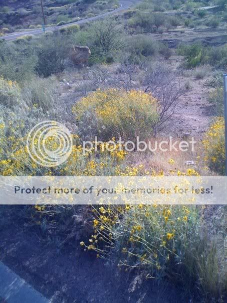
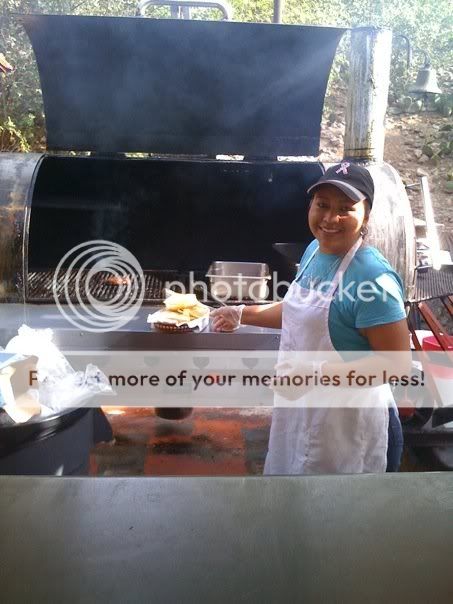
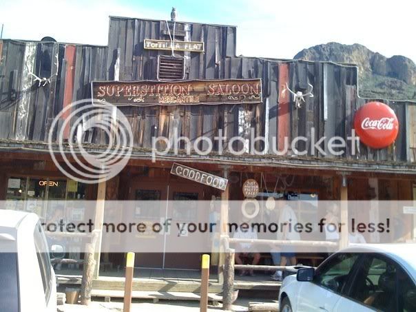
Challenging climbs, beautiful scenery, and the descents were like being on a roller coaster
I also stopped and got a burger at the restaurant and listened to two guys with guitars make jokes and cover country songs
Definitely doing this ride again, thanks for the recommendation, here's a couple pics


Last edited by Tariq08; 03-26-09 at 11:37 PM.
03-27-09, 12:04 AM
#23
Senior Member
Join Date: Jul 2003
Location: Boulder, CO
Posts: 8,546
Mentioned: 83 Post(s)
Tagged: 0 Thread(s)
Quoted: 163 Post(s)
Likes: 0
Liked 2 Times
in
2 Posts
If the latter, well, that's alot of climbing, but it's not ultra steep. If the former, well.... good luck to you. Either way, sounds like a great ride, is it an organized one? which?
edit, fixed, cause I got my former/latter's mixed up the first time
03-27-09, 01:58 AM
#24
Senior Member
Thread Starter
Join Date: Sep 2008
Location: Phoenix
Posts: 856
Bikes: Felt F4
Mentioned: 0 Post(s)
Tagged: 0 Thread(s)
Quoted: 0 Post(s)
Likes: 0
Liked 0 Times
in
0 Posts
03-27-09, 07:32 AM
#25
moth -----> flame
Join Date: Dec 2007
Location: SF Bay Area
Posts: 5,916
Bikes: 11 CAAD 10-4, 07 Specialized Roubaix Comp, 98 Peugeot Horizon
Mentioned: 0 Post(s)
Tagged: 0 Thread(s)
Quoted: 1 Post(s)
Likes: 0
Liked 2 Times
in
2 Posts
Nice job on your ride BTW - sounds nice. I think you'd like the riding round here.
__________________
BF, in a nutshell
BF, in a nutshell