


Cherohala Skyway Fall Foliage Photo Ride Report
 10-21-10, 11:38 AM
#1

VFL For Life
Thread Starter

Join Date: Feb 2005
Location: Knoxville, TN
Posts: 51,332
Bikes: Velo Volmobile
Mentioned: 780 Post(s)
Tagged: 2 Thread(s)
Quoted: 28716 Post(s)
Liked 1,873 Times
in
1,329 Posts
Cherohala Skyway Fall Foliage Photo Ride Report
Tuesday I loaded up my bicycle, drove down to Tellico Plains, TN, and did an out-and-back ride up to the high point on the Cherohala Skyway.
For those of you who aren't familiar with it, the Skyway is
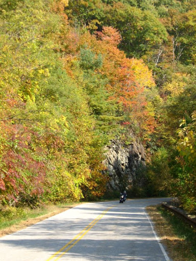
It was a great afternoon to be outside: mostly sunny, light winds, temperatures (in the valley) in the mid-70s. I wasn't the only person who opted to spend it in the mountains. Thanks to the leaf watchers, there was more traffic than I had ever seen on the Skyway before. And yet, in comparison to other mountain roads (namely, the Smoky Mountains) it was still light. Up top you could watch the road for a couple minutes and not see a vehicle drive by.
That's one thing that makes the Skyway such a unique experience. Apart from the sparse traffic, the only evidence of civilization you see in 30+ miles are a couple outhouses and some picnic tables. If you're riding solo, this complete immersion into the wilderness adds an even more epic dynamic to your conquest of the mountains. Although I enjoy the solitude, it would be nice if they had some water up there, though. Hauling your own adds extra weight.
Pictures:
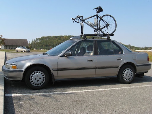
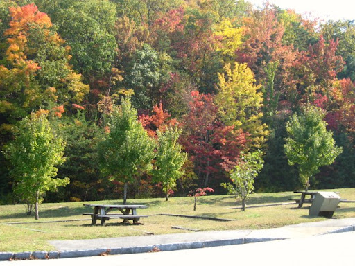
At the Tellico Plains Visitor's Center, minutes before launch time
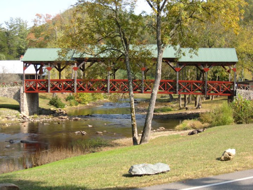
Fancy bridge

The Skyway is a popular motorcycle destination
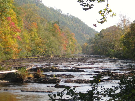
The Tellico River
Further upstream. The Skyway follows the Tellico River for about five miles.
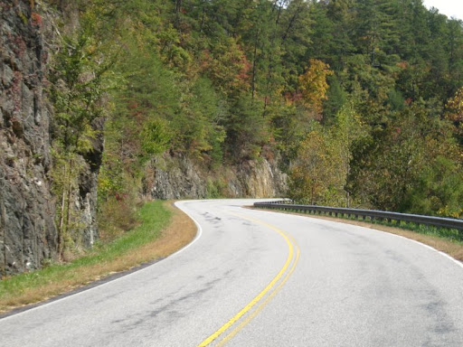
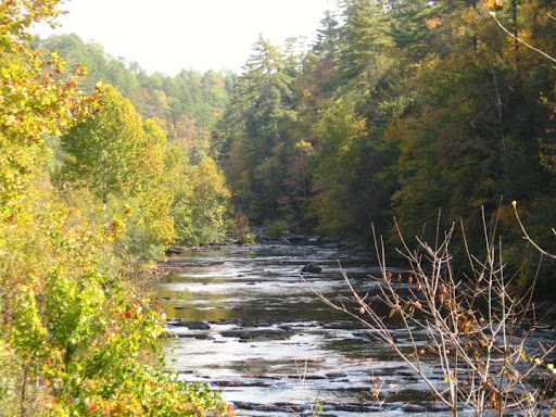
Winding along the Tellico River
I made the trip here for a couple reasons: (1) because I haven't done a challenging climb all year, and (2) to see fall colors.
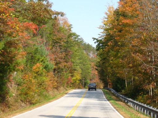
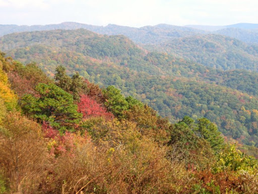
The Skyway was a good choice on both accounts. Although the foliage was past peak above 4,000 feet, there was still plenty of nice color between 2,500-4,500 feet. It was just peaking below 2,500 feet. I had never been on the Cherohala during the fall (only during the summer), so it was a new experience this time.
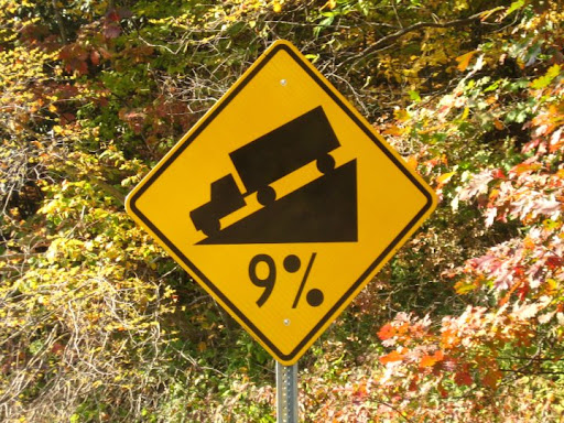
As for the climbing, it's abundant. I estimate that 26 of the 31 miles to the top are uphill. The climbing ranges from an easy five-mile jaunt along the river (18 mph) to miles-long sections of 6-8%, even 9%. Plenty of slogging along at 7-8 mph. Lots of quality face time with the front wheel.
To me, the mental dynamic of a long climb becomes just as challenging as the physical demand. It starts getting in my head when I see nothing but more hill turn after turn after turn. I become psychologically fatigued thinking about the enormity of the mountain, rather than focusing on just reaching the next curve ahead.
There's a life lesson there somewhere.
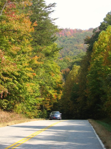
Autumn colors
Virtually every grueling ride I do has a "Doubting Thomas" moment--a time, relatively early in the ordeal, where I question my sanity and ability to complete the mission. In short, I say to myself, "This is a bad idea. Why the hell am I doing this?"
This ride was no exception. About seven miles into the trek, before I had even reached the sustained torturous stretches, my bike started making funny noises. That was all it took to kick my worry motor into overdrive. What if I suffered a catastrophic mechanical or physical breakdown out in this remote country? That would suck. Wouldn't it be much more sensible to turn back and do the easy road along the river instead?
Yes, that would have been the sane thing to do. Which is why I kept going.
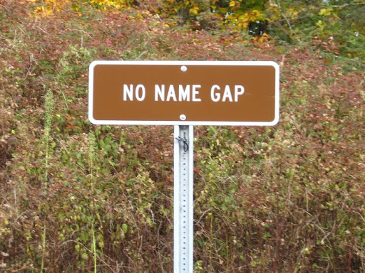
Turkey Creek Overlook
Continued . . .
For those of you who aren't familiar with it, the Skyway is
a 43-mile (69 km) National Scenic Byway that connects Tellico Plains, Tennessee, to Robbinsville, North Carolina in the southeastern United States. Its name is a portmanteau of Cherokee and Nantahala, the two national forests through which it passes.
That's one thing that makes the Skyway such a unique experience. Apart from the sparse traffic, the only evidence of civilization you see in 30+ miles are a couple outhouses and some picnic tables. If you're riding solo, this complete immersion into the wilderness adds an even more epic dynamic to your conquest of the mountains. Although I enjoy the solitude, it would be nice if they had some water up there, though. Hauling your own adds extra weight.
Pictures:
At the Tellico Plains Visitor's Center, minutes before launch time
Fancy bridge
The Skyway is a popular motorcycle destination
The Tellico River
Further upstream. The Skyway follows the Tellico River for about five miles.
Winding along the Tellico River
I made the trip here for a couple reasons: (1) because I haven't done a challenging climb all year, and (2) to see fall colors.
The Skyway was a good choice on both accounts. Although the foliage was past peak above 4,000 feet, there was still plenty of nice color between 2,500-4,500 feet. It was just peaking below 2,500 feet. I had never been on the Cherohala during the fall (only during the summer), so it was a new experience this time.
As for the climbing, it's abundant. I estimate that 26 of the 31 miles to the top are uphill. The climbing ranges from an easy five-mile jaunt along the river (18 mph) to miles-long sections of 6-8%, even 9%. Plenty of slogging along at 7-8 mph. Lots of quality face time with the front wheel.
To me, the mental dynamic of a long climb becomes just as challenging as the physical demand. It starts getting in my head when I see nothing but more hill turn after turn after turn. I become psychologically fatigued thinking about the enormity of the mountain, rather than focusing on just reaching the next curve ahead.
There's a life lesson there somewhere.
Autumn colors
Virtually every grueling ride I do has a "Doubting Thomas" moment--a time, relatively early in the ordeal, where I question my sanity and ability to complete the mission. In short, I say to myself, "This is a bad idea. Why the hell am I doing this?"
This ride was no exception. About seven miles into the trek, before I had even reached the sustained torturous stretches, my bike started making funny noises. That was all it took to kick my worry motor into overdrive. What if I suffered a catastrophic mechanical or physical breakdown out in this remote country? That would suck. Wouldn't it be much more sensible to turn back and do the easy road along the river instead?
Yes, that would have been the sane thing to do. Which is why I kept going.
Turkey Creek Overlook
Continued . . .
 10-21-10, 11:39 AM
#2
VFL For Life
Thread Starter
Join Date: Feb 2005
Location: Knoxville, TN
Posts: 51,332
Bikes: Velo Volmobile
Mentioned: 780 Post(s)
Tagged: 2 Thread(s)
Quoted: 28716 Post(s)
Liked 1,873 Times
in
1,329 Posts
The reds were the best colors along the route. The yellows and oranges weren't as brilliant.

You can faintly see the road winding through the "V" in the mountain profile above.

Entering foreign territory at Unicoi Crest. The western ascent includes almost 25 miles of Tennessee Highway 165 and 7 miles on North Carolina Highway 143.
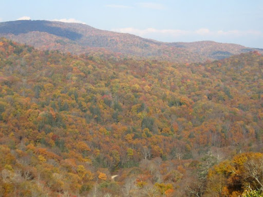
Colors were past peak color above 4,000 feet. Many of the leaves had already fallen.
No rest for the weary on the mighty Cherohala.
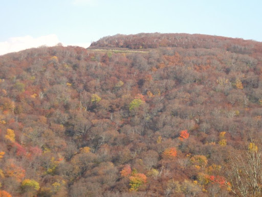
At last, the top of the Skyway is within sight (above). Note all the barren trees.
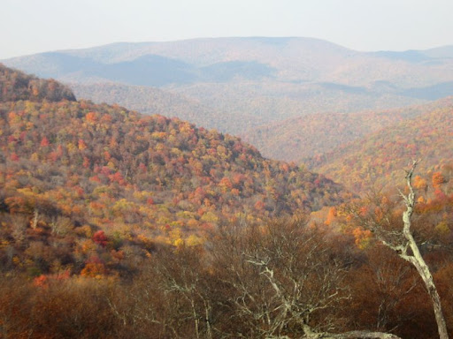
Near the top of Skyway. Curiously, the panorama from the highest overlook isn't very good. There are much better views just to the east and west of it.
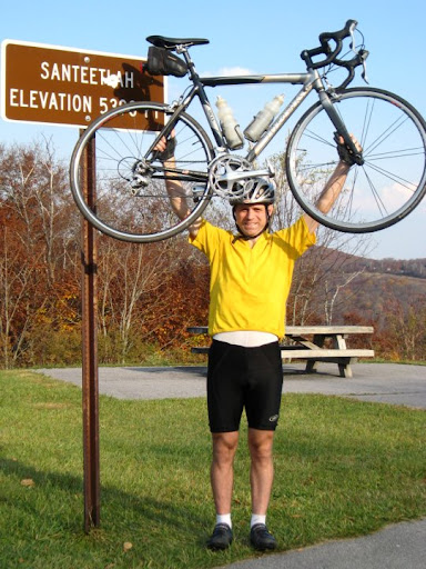
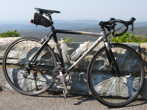
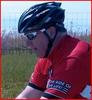
Skyway conquered! At Santeetlah Overlook, elevation 5,390 feet.
It was pleasant on the summit for October. The sun was still out and there was only a light breeze. I've felt colder up there in June.
I sat for several minutes listening to a motorcyclist loudly talking on his phone. I wanted to get someone to take a picture. A couple vehicles pulled over, but no one lingered long enough for me to approach them. Finally a nice lady from Florida emerged from a van and obliged. She took not one, but several. Holding your bike up by a sign isn't the most natural of poses.
It's a great feeling sitting on the summit. You quickly forget the sweat and pain it took to get there and bask in the air of your velo superiority. To borrow a movie phrase, you feel like king of the world, or at least king of that mountain. But then after a bit you turn around and head back down, making the whole exercise seem rather pointless.
Entering uncharted territory.
Continued . . .
10-21-10, 11:39 AM
#3
VFL For Life
Thread Starter
Join Date: Feb 2005
Location: Knoxville, TN
Posts: 51,332
Bikes: Velo Volmobile
Mentioned: 780 Post(s)
Tagged: 2 Thread(s)
Quoted: 28716 Post(s)
Liked 1,873 Times
in
1,329 Posts
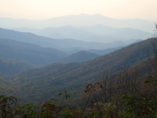
Evening haze envelops the Unicoi Mountains

One last look at the ageless mountains.
I take a bizarre sense of pride in two otherwise trivial aspects of the ride. First, I never used the lowest two gears on the bike, even on the 9% grades. Some cyclists like to sit and spin; I like to stand and mash. It works for me. Besides, it's reassuring to know that there's an easier gear available if you need it.
Second, I consumed just over two bottles of water during the ride. No food. I did have emergency provisions (and warmer clothing) in a backpack--which, incidentally, was rather uncomfortable when I was sweating--but I didn't need it. I only drank some of the extra water, the rest of the stuff I hauled for nothing. But better to be safe than sorry. If you bonk (low blood sugar) or get the chills miles from anywhere, you've got a big problem.
Fortunately, nothing went wrong. I didn't cramp and my squeaky bike didn't break down. I rolled back into Tellico Plains with amble daylight, a bit tired, but exhilarated from another velo mountaintop experience.
Ride stats
Distance: 62.5 miles
Time: 4:28
The End.
10-21-10, 11:44 AM
#4
Senior Member
Join Date: Sep 2005
Location: In the foothills of Los Angeles County
Posts: 25,371
Mentioned: 8 Post(s)
Tagged: 0 Thread(s)
Quoted: 8330 Post(s)
Liked 9,152 Times
in
4,517 Posts
Cool pics. I'm guessing there is a lot of up and down no matter which way you go?
 10-21-10, 11:52 AM
#6
Senior Member

Join Date: Jan 2009
Location: GA
Posts: 1,155
Bikes: Helix, HonkyTonk, NailTrail
Mentioned: 0 Post(s)
Tagged: 0 Thread(s)
Quoted: 6 Post(s)
Likes: 0
Liked 2 Times
in
2 Posts
Niiice! Thanks for the pictures.
I ride the gaps and the mountains around Chattanooga often. I've been on the Dragon with some sports car enthusiasts. Love the area.
I want to ride the Cherohala Challenge route some day, maybe soonish, but it's 120ish miles. Any advice on spots, general store, gas stations to refill bottles in the 40-80 mile region?
10-21-10, 11:54 AM
#7

Senior Member

Join Date: Sep 2007
Location: Spokane/Tri-Cities WA
Posts: 1,385
Bikes: mountain bike, road bike
Mentioned: 0 Post(s)
Tagged: 0 Thread(s)
Quoted: 7 Post(s)
Likes: 0
Liked 0 Times
in
0 Posts
Looks like a great ride. Some fantastic photos. Thanks for sharing.
10-21-10, 11:57 AM
#8
VFL For Life
Thread Starter
Join Date: Feb 2005
Location: Knoxville, TN
Posts: 51,332
Bikes: Velo Volmobile
Mentioned: 780 Post(s)
Tagged: 2 Thread(s)
Quoted: 28716 Post(s)
Liked 1,873 Times
in
1,329 Posts
Here's an elevation profile from a century route. I rode backwards from the end to about the 85 mile mark, then back down.
 10-21-10, 11:59 AM
#9

pan y agua

Join Date: Aug 2005
Location: Jacksonville
Posts: 31,311
Bikes: Willier Zero 7; Merlin Extralight; Calfee Dragonfly tandem, Calfee Adventure tandem; Cervelo P2; Motebecane Ti Fly 29er; Motebecanne Phantom Cross; Schwinn Paramount Track bike
Mentioned: 17 Post(s)
Tagged: 0 Thread(s)
Quoted: 1458 Post(s)
Liked 735 Times
in
376 Posts
Have you done Tail of the Dragon?
__________________
You could fall off a cliff and die.
You could get lost and die.
You could hit a tree and die.
OR YOU COULD STAY HOME AND FALL OFF THE COUCH AND DIE.
You could fall off a cliff and die.
You could get lost and die.
You could hit a tree and die.
OR YOU COULD STAY HOME AND FALL OFF THE COUCH AND DIE.
10-21-10, 12:00 PM
#10
Mostly Harmless

Join Date: Jul 2008
Location: Chittenango, NY
Posts: 56,642
Bikes: Have two wheels
Mentioned: 169 Post(s)
Tagged: 2 Thread(s)
Quoted: 13743 Post(s)
Liked 4,547 Times
in
2,520 Posts
Beautiful pictures and nice commentary.
Thanks for sharing your epic adventure.
Thanks for sharing your epic adventure.
10-21-10, 12:08 PM
#11
Senior Member
Join Date: May 2010
Location: Long Island, NY
Posts: 1,637
Bikes: '85 Rossin Super Record, '88 Specialized Sequoia, '10 Raleigh Cadent FT2, '10 Specialized Roubaix Elite
Mentioned: 0 Post(s)
Tagged: 0 Thread(s)
Quoted: 0 Post(s)
Likes: 0
Liked 0 Times
in
0 Posts
Nice recap and pix...thanks VV
 10-21-10, 12:12 PM
#13
VFL For Life
Thread Starter
Join Date: Feb 2005
Location: Knoxville, TN
Posts: 51,332
Bikes: Velo Volmobile
Mentioned: 780 Post(s)
Tagged: 2 Thread(s)
Quoted: 28716 Post(s)
Liked 1,873 Times
in
1,329 Posts
If you're riding the route that the organized ride does it's actually the end of the ride that's the problem. There's a campground you go by at Lake Santeetlah where you can get water (I think it's in the mile 70-75 range) and then there's no water facets that I'm aware of until Tellico Plains. I believe I read there's a spring near the road somewhere along the way, but I've never spotted it.
10-21-10, 12:14 PM
#14
John Wayne Toilet Paper
Join Date: Feb 2006
Location: Roanoke
Posts: 1,952
Bikes: BH carbon, Ritchey steel, Kona aluminum
Mentioned: 0 Post(s)
Tagged: 0 Thread(s)
Quoted: 1 Post(s)
Liked 0 Times
in
0 Posts
I spent many weekends in that area when I lived in NC and VA and rode the NC side from Robbinsville to Santeetlah, but one thing about your post stood out.. They revised the elevation at Santeetlah!? It used to claim 5377 ft.
10-21-10, 12:17 PM
#15
VFL For Life
Thread Starter
Join Date: Feb 2005
Location: Knoxville, TN
Posts: 51,332
Bikes: Velo Volmobile
Mentioned: 780 Post(s)
Tagged: 2 Thread(s)
Quoted: 28716 Post(s)
Liked 1,873 Times
in
1,329 Posts
Yes, that's part of the Cherohala Challenge century ride (June) that another poster mentioned. I've done it five times. This year, however, it was canceled due to a rock slide.

 10-21-10, 12:24 PM
#18
Prty good at drinkn' beer

Join Date: May 2010
Location: VA Beach
Posts: 199
Bikes: Cannondale R1000Aero Trek 7000
Mentioned: 0 Post(s)
Tagged: 0 Thread(s)
Quoted: 0 Post(s)
Likes: 0
Liked 0 Times
in
0 Posts
Beautiful area. I was there about a year and a half ago on my motorcycle. I'd love to hit it on a bicycle.
10-21-10, 12:26 PM
#19
Has coddling tendencies.
Whether it be Mario Cervelo, iJen or VV here, it never fails to amaze me how cyclists with such noodly arms can raise their bikes over their heads.
10-21-10, 12:27 PM
#20
VFL For Life
Thread Starter
Join Date: Feb 2005
Location: Knoxville, TN
Posts: 51,332
Bikes: Velo Volmobile
Mentioned: 780 Post(s)
Tagged: 2 Thread(s)
Quoted: 28716 Post(s)
Liked 1,873 Times
in
1,329 Posts
Mysterious. I googled and a sign there used to say that, but now it doesn't. Maybe there was volcanic activity that boosted it up?
File photo.

File photo.
10-21-10, 12:29 PM
#21
John Wayne Toilet Paper
Join Date: Feb 2006
Location: Roanoke
Posts: 1,952
Bikes: BH carbon, Ritchey steel, Kona aluminum
Mentioned: 0 Post(s)
Tagged: 0 Thread(s)
Quoted: 1 Post(s)
Liked 0 Times
in
0 Posts
Yeah, I could make out the 5390 in your first post... and verified my own photo of it showing 5377. Weird. The USGS must have issued updates after some recent high res mapping.
10-21-10, 12:40 PM
#23
Artificial Member

Join Date: Jan 2010
Location: Cyberspace
Posts: 7,159
Bikes: Retrospec Judd, Dahon Boardwalk, Specialized Langster
Mentioned: 31 Post(s)
Tagged: 0 Thread(s)
Quoted: 6796 Post(s)
Liked 5,500 Times
in
3,238 Posts
Wow! All the time I traveled that area I missed that!
Thanks for showing it to me.
Thanks for showing it to me.
 10-21-10, 12:45 PM
#25
pan y agua
Join Date: Aug 2005
Location: Jacksonville
Posts: 31,311
Bikes: Willier Zero 7; Merlin Extralight; Calfee Dragonfly tandem, Calfee Adventure tandem; Cervelo P2; Motebecane Ti Fly 29er; Motebecanne Phantom Cross; Schwinn Paramount Track bike
Mentioned: 17 Post(s)
Tagged: 0 Thread(s)
Quoted: 1458 Post(s)
Liked 735 Times
in
376 Posts
I thought the Appalachian Mountains were eroding? Shouldn't it be down like a hundredth of an inch?
__________________
You could fall off a cliff and die.
You could get lost and die.
You could hit a tree and die.
OR YOU COULD STAY HOME AND FALL OFF THE COUCH AND DIE.
You could fall off a cliff and die.
You could get lost and die.
You could hit a tree and die.
OR YOU COULD STAY HOME AND FALL OFF THE COUCH AND DIE.