


Can someone please help me determine this grade?
 06-16-11, 12:43 PM
#26
Do a barrel roll.
Thread Starter
Join Date: Jun 2009
Location: Rockledge, FL
Posts: 201
Bikes: Trek 7.2 FX
Mentioned: 0 Post(s)
Tagged: 0 Thread(s)
Quoted: 0 Post(s)
Likes: 0
Liked 0 Times
in
0 Posts
Actually the OP loves (very basic) math. I'm a man, I want to quantify everything. Everything must be a list and that list must be in order from best to worst and next to 19 other lists that make me feel like I might actually be making progress.
 06-16-11, 01:22 PM
#27
Rabid Member

 06-16-11, 01:38 PM
#28
Do a barrel roll.
Thread Starter
Join Date: Jun 2009
Location: Rockledge, FL
Posts: 201
Bikes: Trek 7.2 FX
Mentioned: 0 Post(s)
Tagged: 0 Thread(s)
Quoted: 0 Post(s)
Likes: 0
Liked 0 Times
in
0 Posts
06-16-11, 02:07 PM
#29

Longing for a Tail Wind

For the life of me I don't know why I spent time on this but -- if route 528 is the highway, it looks like nautical clearance is 65 feet:
https://www.nauticalcharts.noaa.gov/n...rchbychart.php
https://www.nauticalcharts.noaa.gov/n...rchbychart.php
06-16-11, 02:10 PM
#30
Do a barrel roll.
Thread Starter
Join Date: Jun 2009
Location: Rockledge, FL
Posts: 201
Bikes: Trek 7.2 FX
Mentioned: 0 Post(s)
Tagged: 0 Thread(s)
Quoted: 0 Post(s)
Likes: 0
Liked 0 Times
in
0 Posts
06-16-11, 02:17 PM
#31
pan y agua

Join Date: Aug 2005
Location: Jacksonville
Posts: 31,302
Bikes: Willier Zero 7; Merlin Extralight; Calfee Dragonfly tandem, Calfee Adventure tandem; Cervelo P2; Motebecane Ti Fly 29er; Motebecanne Phantom Cross; Schwinn Paramount Track bike
Mentioned: 17 Post(s)
Tagged: 0 Thread(s)
Quoted: 1447 Post(s)
Liked 724 Times
in
371 Posts
For the life of me I don't know why I spent time on this but -- if route 528 is the highway, it looks like nautical clearance is 65 feet:
https://www.nauticalcharts.noaa.gov/n...rchbychart.php
https://www.nauticalcharts.noaa.gov/n...rchbychart.php
My bet is that the average grade of that bridge is in the 4 to 6% range, just based on GPS data riding over a lot of simliar bridges around here.
__________________
You could fall off a cliff and die.
You could get lost and die.
You could hit a tree and die.
OR YOU COULD STAY HOME AND FALL OFF THE COUCH AND DIE.
You could fall off a cliff and die.
You could get lost and die.
You could hit a tree and die.
OR YOU COULD STAY HOME AND FALL OFF THE COUCH AND DIE.
06-16-11, 02:32 PM
#32
Senior Member
Join Date: Aug 2008
Location: I live in Montgomery, Alabama.
Posts: 105
Bikes: Cervelo RS; Marin 29er; Masi; Gary Fisher MB
Mentioned: 0 Post(s)
Tagged: 0 Thread(s)
Quoted: 0 Post(s)
Likes: 0
Liked 0 Times
in
0 Posts
My father bought property in Merritt Island when there was only one red light. I attended Edgewood Junior Hight when I was in the eighth grade. So, I am familiar with the area. I know it is hard to find a place to work on your climbing legs, but I don't think this bridge is a safe place to ride a bike, unless you ride very early in the morning or late at night. I still have a brother who lives in Brevard County. Take care!
06-16-11, 03:37 PM
#33
Senior Member

Join Date: Oct 2004
Location: Huntington Beach, CA
Posts: 7,085
Bikes: Cervelo Prodigy
Mentioned: 4 Post(s)
Tagged: 0 Thread(s)
Quoted: 478 Post(s)
Likes: 0
Liked 87 Times
in
67 Posts
Porkponey,
The man from the Florida Transportation dept says the bridge on the Indian River further to the west is 2,300' long and the gradient is 5%. The other bridge is 820' long with the same gradient.
The man from the Florida Transportation dept says the bridge on the Indian River further to the west is 2,300' long and the gradient is 5%. The other bridge is 820' long with the same gradient.
06-16-11, 03:49 PM
#34
Senior Member
Join Date: May 2008
Location: Denver
Posts: 928
Mentioned: 0 Post(s)
Tagged: 0 Thread(s)
Quoted: 0 Post(s)
Likes: 0
Liked 0 Times
in
0 Posts
Why in the world you would want to ride when there is 2 feet of snow on the ground. The lifts would be turning and riding is just a good way to stay in shape for what's really important...skiing!
06-16-11, 09:41 PM
#35
Full Member
Measuring the overall height and length of the bridge doesn't help because that only gives you the average grade, which would be significantly less than the steepest part due to the curvature. I think you're looking for the steepest part, which could be taken at a point using a level or whatnot.
Another idea is to take a true sideways picture of the steepest part (as close to perpendicular as you can get) and after straightening the photo to make sure the water is perfectly level (or make sure columns are vertical in the middle of your pic), crop it so that the corners of the steep part match the corners of the photo, then use the width and height of the cropped image. Taking a telephoto shot would reduce distortion vs. a wide angle.
Another idea is to take a true sideways picture of the steepest part (as close to perpendicular as you can get) and after straightening the photo to make sure the water is perfectly level (or make sure columns are vertical in the middle of your pic), crop it so that the corners of the steep part match the corners of the photo, then use the width and height of the cropped image. Taking a telephoto shot would reduce distortion vs. a wide angle.
06-17-11, 12:47 AM
#36
Shop Wench
Join Date: Mar 2009
Location: California
Posts: 284
Mentioned: 0 Post(s)
Tagged: 0 Thread(s)
Quoted: 0 Post(s)
Likes: 0
Liked 0 Times
in
0 Posts
The next step is for the OP to go on Google Earth and measure the length of the bridge - or actually, half the bridge. Then, knowing the rise and the run, an average grade can be calculated.
06-17-11, 06:56 AM
#37
New Orleans
Join Date: Jan 2006
Posts: 2,794
Mentioned: 1 Post(s)
Tagged: 0 Thread(s)
Quoted: 157 Post(s)
Likes: 0
Liked 3 Times
in
3 Posts
Just use the DOT's 5%.
The crude ways we have suggested to measure then calculate/look up the angle then the grade just won't be very accurate.Fun maybe, but not accurate.
The crude ways we have suggested to measure then calculate/look up the angle then the grade just won't be very accurate.Fun maybe, but not accurate.
06-17-11, 07:22 AM
#38
Do a barrel roll.
Thread Starter
Join Date: Jun 2009
Location: Rockledge, FL
Posts: 201
Bikes: Trek 7.2 FX
Mentioned: 0 Post(s)
Tagged: 0 Thread(s)
Quoted: 0 Post(s)
Likes: 0
Liked 0 Times
in
0 Posts
Driving over the 192 causeway last night (the first picture posted) with my iphone clinometer showed between 5 and 7* which doesn't add up to a 5% grade. I'll have to get out there with a level or something I guess.
06-17-11, 07:22 AM
#39

Northern Rider
Join Date: Jan 2007
Location: Toronto, Ontario
Posts: 435
Bikes: 1999 Litespeed Tuscany 105, 2007 Marin Palisades Trail, 2006 Burley Duet tandem
Mentioned: 5 Post(s)
Tagged: 0 Thread(s)
Quoted: 115 Post(s)
Liked 811 Times
in
203 Posts
Find the bridge on Google Earth, measure the elevation at the top and bottom, use the ruler to measure the distance and calculate. Not perfectly accurate but probably pretty close.
06-17-11, 07:39 AM
#40
In Real Life

Join Date: Jan 2003
Location: Down under down under
Posts: 52,152
Bikes: Lots
Mentioned: 141 Post(s)
Tagged: 0 Thread(s)
Quoted: 3203 Post(s)
Liked 596 Times
in
329 Posts
Not being able to see both sides all that well, as a guess I'd say .... maybe ... 3%. Not very steep. But that's just a guess.
If you want to measure the grade, it is easy to do. Rowan (my husband) shows you how in these photos ...
https://www.flickr.com/photos/machka-...detail/?page=9
The horizontal bar is exactly 1 metre long ...
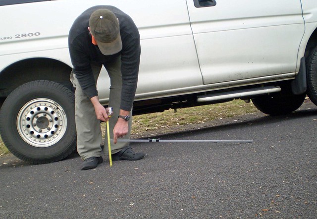
And this part measured at 16.5% ... it's the steep part of this particular hill, just up the road from us.
The measuring tape is measuring in centimetres ...

And this part of the hill is measuring at about 8%. This is the gradual part of the same hill that goes to 16.5%.

If you want to measure the grade, it is easy to do. Rowan (my husband) shows you how in these photos ...
https://www.flickr.com/photos/machka-...detail/?page=9
The horizontal bar is exactly 1 metre long ...
And this part measured at 16.5% ... it's the steep part of this particular hill, just up the road from us.
The measuring tape is measuring in centimetres ...
And this part of the hill is measuring at about 8%. This is the gradual part of the same hill that goes to 16.5%.
__________________
Rowan
My fave photo threads on BF
Century A Month Facebook Group
Machka's Website
Photo Gallery
Rowan
My fave photo threads on BF
Century A Month Facebook Group
Machka's Website
Photo Gallery
06-17-11, 07:39 AM
#41
New Orleans
Join Date: Jan 2006
Posts: 2,794
Mentioned: 1 Post(s)
Tagged: 0 Thread(s)
Quoted: 157 Post(s)
Likes: 0
Liked 3 Times
in
3 Posts
The initial approach to a bridge will have the lowest grade
The 5% is just an average number over the whole stretch(like others have said).
7% seems a bit high.
Phones now have grade measuring devices ???
How do they do that I wonder?
I kinda doubt they actually have a sensor(bubble level equivalent)- are they using the GPS system??
I wonder how good the GPS is in respect to altitude? Good to 10 feet maybe- or good to 1 foot?? Few inches?
I thought there were some military/GOV restrictions on how accurate that sort of info can be? I suspect it can be EXTREMELY ACCURATE-maybe to the cm in altitude??
Machka's stuff is perfect-The pictures are perfect for showing how to measure a grade-
Of course 16% is pretty dramatic,and it is tougher to measure smaller grades- nice long piece of angle aluminum makes it easier-longer the better.
Last edited by phoebeisis; 06-17-11 at 07:44 AM.
06-17-11, 07:47 AM
#42
pan y agua
Join Date: Aug 2005
Location: Jacksonville
Posts: 31,302
Bikes: Willier Zero 7; Merlin Extralight; Calfee Dragonfly tandem, Calfee Adventure tandem; Cervelo P2; Motebecane Ti Fly 29er; Motebecanne Phantom Cross; Schwinn Paramount Track bike
Mentioned: 17 Post(s)
Tagged: 0 Thread(s)
Quoted: 1447 Post(s)
Liked 724 Times
in
371 Posts
I wonder how good the GPS is in respect to altitude? Good to 10 feet maybe- or good to 1 foot?? Few inches?
I thought there were some military/GOV restrictions on how accurate that sort of info can be? I suspect it can be EXTREMELY ACCURATE-maybe to the cm in altitude??
I thought there were some military/GOV restrictions on how accurate that sort of info can be? I suspect it can be EXTREMELY ACCURATE-maybe to the cm in altitude??
For example, I've done climbs where the Garmin was telling me the maximum grade was 28%, but when you later look at the file in a program like ridewithgps, the maximum grade was only 17%
Also I believe that the 705 uses a barometer, corrected by GPS data, so its not relying entirely on GPS for alititude.
__________________
You could fall off a cliff and die.
You could get lost and die.
You could hit a tree and die.
OR YOU COULD STAY HOME AND FALL OFF THE COUCH AND DIE.
You could fall off a cliff and die.
You could get lost and die.
You could hit a tree and die.
OR YOU COULD STAY HOME AND FALL OFF THE COUCH AND DIE.
Last edited by merlinextraligh; 06-17-11 at 07:51 AM.
06-17-11, 07:51 AM
#43
Senior Member
Join Date: Oct 2009
Location: Virginia/DC
Posts: 1,454
Bikes: quite a few
Mentioned: 0 Post(s)
Tagged: 0 Thread(s)
Quoted: 1 Post(s)
Likes: 0
Liked 0 Times
in
0 Posts
Interesting read, as there's a steep steep hill near me - but it's very short. I've tried bikemyride but it's not accurate around there. The inclinometer looks good but only goes to +/- 21% grade?  Maybe I can find a topographic map somewhere.
Maybe I can find a topographic map somewhere.
06-17-11, 07:58 AM
#44
In Real Life
Join Date: Jan 2003
Location: Down under down under
Posts: 52,152
Bikes: Lots
Mentioned: 141 Post(s)
Tagged: 0 Thread(s)
Quoted: 3203 Post(s)
Liked 596 Times
in
329 Posts

Rowan went with a 1-metre long piece of angle aluminum because 1 metre = 100 cm, and if the measuring tape said 8 cm, then 8/100 = 8%. A person could probably use a standard wood or plastic metre stick.
__________________
Rowan
My fave photo threads on BF
Century A Month Facebook Group
Machka's Website
Photo Gallery
Rowan
My fave photo threads on BF
Century A Month Facebook Group
Machka's Website
Photo Gallery
06-17-11, 09:37 AM
#45
New Orleans
Join Date: Jan 2006
Posts: 2,794
Mentioned: 1 Post(s)
Tagged: 0 Thread(s)
Quoted: 157 Post(s)
Likes: 0
Liked 3 Times
in
3 Posts
Hmmm, now I'm really curious.
I ride up and down the Mississippi river levee everyday(4 miles upriver-W- of NOLA).If I ride on top of the levee I won't get much of a workout because I just won't push myself.
I've been curious what the grade was, but not curious enough to actually measure it.
I'm guessing it is 25%-maybe 20 feet vertically 80 feet horizontally.The face facing the river is much steeper.I ride the other face.
06-17-11, 11:11 AM
#46
Portland Fred

If you want to do thing the BF way, your approach is all wrong. First, lose the pic. Just tell us about some place that's crazy steep but don't identify the location except in the vaguest terms. Then say it's at least 18%
06-17-11, 12:24 PM
#48
Senior Member

Join Date: Jul 2009
Location: Mount Juliet, TN
Posts: 480
Bikes: T1K
Mentioned: 0 Post(s)
Tagged: 0 Thread(s)
Quoted: 0 Post(s)
Likes: 0
Liked 0 Times
in
0 Posts
06-17-11, 02:10 PM
#49
Do a barrel roll.
Thread Starter
Join Date: Jun 2009
Location: Rockledge, FL
Posts: 201
Bikes: Trek 7.2 FX
Mentioned: 0 Post(s)
Tagged: 0 Thread(s)
Quoted: 0 Post(s)
Likes: 0
Liked 0 Times
in
0 Posts
06-17-11, 02:11 PM
#50
Do a barrel roll.
Thread Starter
Join Date: Jun 2009
Location: Rockledge, FL
Posts: 201
Bikes: Trek 7.2 FX
Mentioned: 0 Post(s)
Tagged: 0 Thread(s)
Quoted: 0 Post(s)
Likes: 0
Liked 0 Times
in
0 Posts
And yes, the phone has a clinometer in it that uses the accelerometer in the phone to figure out orientation and angle. Next to a protractor it's accurate to one degree.
Degree being a degree and not a percentage of grade.
Degree being a degree and not a percentage of grade.