


Metro Boston: Good ride today?

 08-12-12, 07:10 AM
#2027
Senior Member
Join Date: May 2011
Posts: 3,175
Mentioned: 15 Post(s)
Tagged: 0 Thread(s)
Quoted: 534 Post(s)
Liked 1,737 Times
in
890 Posts
I went back, picked up the glass, cut my finger, reveled in grumbling about humans again and then slowed even more and picked up a couple of more pieces of trash.

I've no idea if a very small and very rare good deed makes any difference but I do appreciate where we ride.
I've no idea if a very small and very rare good deed makes any difference but I do appreciate where we ride.
rod
08-12-12, 07:54 AM
#2028
Senior Member
Join Date: May 2011
Posts: 3,175
Mentioned: 15 Post(s)
Tagged: 0 Thread(s)
Quoted: 534 Post(s)
Liked 1,737 Times
in
890 Posts
A couple of weeks ago I tried to ride to Harvard, but bailed because of a line of thunderstorms (then got rained on anyway). That was the beginning of a series of wet-but-pleasant rides. Yesterday, I tried Harvard again, and made it this time; got wet, too. Although my phone decided to turn itself off three quarters of the way through the route, this track shows the most interesting bits of the 64 miles.
As before, the plan was to ride out Route 117 to Stow, then cut diagonally up to Harvard. As before, there was a line of thunderstorms in Worcester County, but on the weather radar it looked like they were moving rapidly North. I paused while crossing the river on Sudbury Road, Concord to take a picture of the clouds in the general direction I was heading. Not like I hadn't been warned...

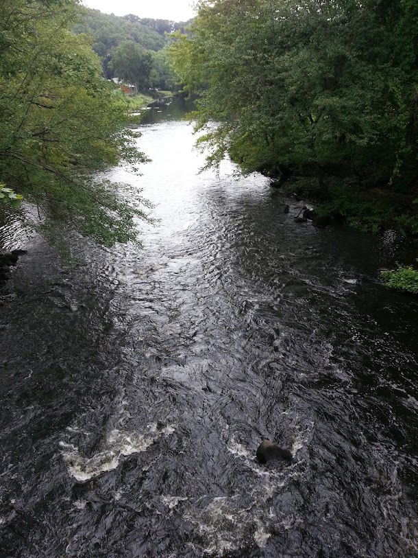
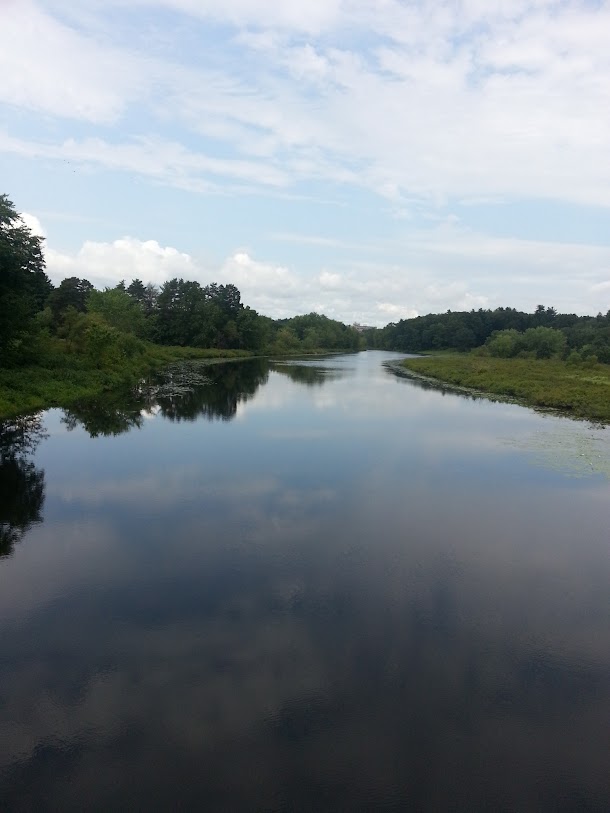
Still, it wasn't raining where I was, so down Route 117 I went, passing through Concord and Sudbury. Paused on the bridge over the Assabet River in Maynard, noting the high water, which had to come from somewhere. Warned again... Still, the weather radar was encouraging.
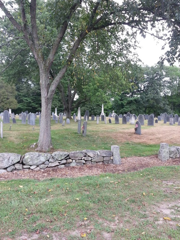
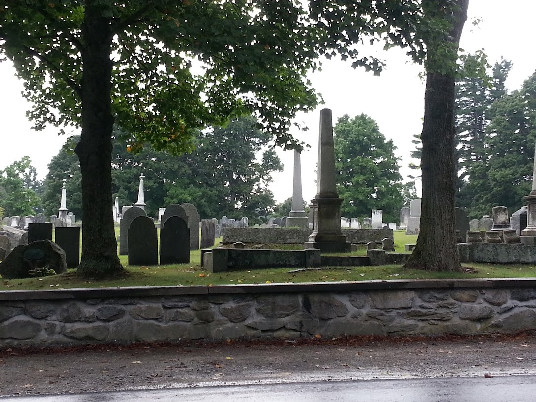
Rolled into Stow on Route 117, enjoying the mix of architectural styles, including a whimsical Victorian Gingerbread house. Stow used to be called "Pompositticut", which sounds to my ear like something rude the Wampanoags used to say about Cotton Mather. At Pompositticut Road, there's an old burying ground.
I left Route 117 at Harvard Road, which was declared with a degree of redundancy that Claude Shannon would have approved.

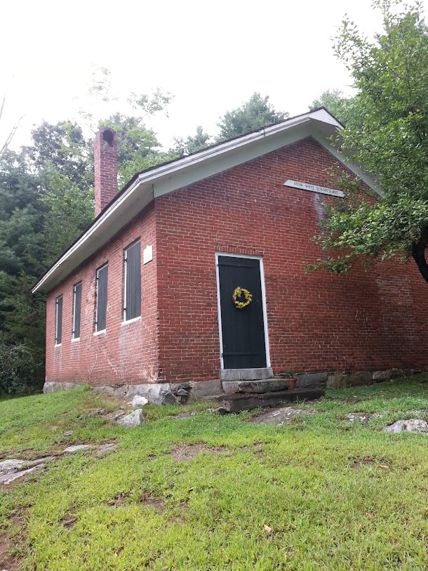
Suddenly, things got quiet, and stayed that way for most of the rest of the ride; no more Route 117 traffic. No traffic to speak of, period. The pavement was quite wet, though; the storm had passed this way. Stopped to photograph the West School.
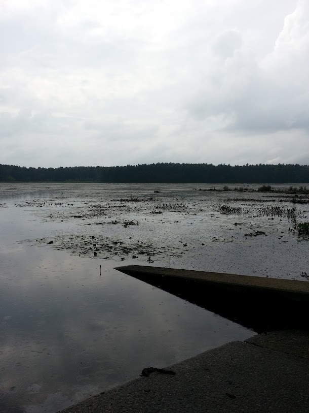
Continued on Harvard Road to the Delaney Flood Control Site/Wildlife Management Area. This is an extensive wetland, surrounded by trails, that I marked as worth revisiting for a hike. I stopped for a break at the boat landing in Stow, and enjoyed a squadron of dragonflies dive-bombing mosquito larvae, with an audible plop at the point of contact--this was a measure of just how quiet things had become. A gentle shower began to fall, the splashes just visible in this photograph.
Followed Harvard Road across the waist of Delaney Pond, which it bisects, becoming Finns Road at the Harvard line. In Harvard now, and in the rain, picked up Stow Road, and followed that Northwest under I-495. At this point, the storm I had been playing tag with all afternoon caught me, with a sharp, thoroughly soaking downpour. This turned out to be highly localized, I kept riding and after a few minutes we parted ways. By way of a joke, the sun came out...

and I enjoyed the humor of it...
A little farther down the road came the Great Elms Farmland, a truly beautiful spot.

I rode on into the center of Harvard.
There's a living population there too, of course, and some architecturally-interesting and felicitous structures, but I've reached my image limit for this post. One structure I particularly appreciated was a port-a-john at a road construction site in the center of town: convenient!
At this point, the storm resumed the game of tag, and rain began to fall again. I took off down Old Littleton Road, roughly Northeast. Last year, I had mentioned to a colleague who lives in Harvard that I was minded to ride my bicycle out to his town; he chuckled, and said, "You know we have hills..." Old Littleton Road may have been what he had in mind: steep up-and-down grades in rapid succession, followed by a long, slow up-hill and long, fast down-hill in the rain that had me being careful of skids on the wet pavement, moving fast enough that the fat rain-drops stung the skin; at one point, zipped through a (shallow) flooded section like Charleton Heston parting the Red Sea. In my experience, "Old" in a road name means "hilly" if there are any hills to be had, and Harvard is in Worcester County, so I guess hills are definitional. Old Littleton Road has a fine complement of tasteful houses and farm buildings reprising 400 years of Massachusetts architecture, and I noticed that on the slow, up-hill segments.
After crossing Route 2 (under? over? can't remember, but there were no ramps), got to Littleton itself. The center of town looked interesting, with an old railroad depot that looked like a worthwhile restoration project interrupted mid-way. Picked up Harwood Avenue (hard to find, no sign), and rolled down a long hill to a causeway across Mill Pond. There was no traffic, and enough rain was falling to give the scenes, as they changed--a succession of farms, houses, and conservation areas--an other-worldly aspect. Up from Mill Pond in rolling hills, over I-495, Harwood Avenue brought me to Newtown Road, a busy artery which I hopped off after a block onto Nashoba Road, continuing to Nagog Hill Road and its extensive orchard. Swooped into Acton over rolling hills in heavy rain, past Nagog Pond green in the rain-light, glad of the very light traffic. Took Route 27 to Brooks Street, jogged onto Great Road to Strawbery Hill Road, which put me back on familiar ground. Also back on dry ground: as soon as I crossed the Concord line, the rain ended, and the pavement was soon bone-dry. The Special Effects Department outdid themselves with that. Rode back home, enjoying an evening ride on the Minuteman. Took my sweetie out for sushi and a Sapporo, after that.
These are good roads, mostly new to me. Look forward to trying them again without all that rain.
rod
As before, the plan was to ride out Route 117 to Stow, then cut diagonally up to Harvard. As before, there was a line of thunderstorms in Worcester County, but on the weather radar it looked like they were moving rapidly North. I paused while crossing the river on Sudbury Road, Concord to take a picture of the clouds in the general direction I was heading. Not like I hadn't been warned...
Still, it wasn't raining where I was, so down Route 117 I went, passing through Concord and Sudbury. Paused on the bridge over the Assabet River in Maynard, noting the high water, which had to come from somewhere. Warned again... Still, the weather radar was encouraging.
Rolled into Stow on Route 117, enjoying the mix of architectural styles, including a whimsical Victorian Gingerbread house. Stow used to be called "Pompositticut", which sounds to my ear like something rude the Wampanoags used to say about Cotton Mather. At Pompositticut Road, there's an old burying ground.
I left Route 117 at Harvard Road, which was declared with a degree of redundancy that Claude Shannon would have approved.
Suddenly, things got quiet, and stayed that way for most of the rest of the ride; no more Route 117 traffic. No traffic to speak of, period. The pavement was quite wet, though; the storm had passed this way. Stopped to photograph the West School.
Continued on Harvard Road to the Delaney Flood Control Site/Wildlife Management Area. This is an extensive wetland, surrounded by trails, that I marked as worth revisiting for a hike. I stopped for a break at the boat landing in Stow, and enjoyed a squadron of dragonflies dive-bombing mosquito larvae, with an audible plop at the point of contact--this was a measure of just how quiet things had become. A gentle shower began to fall, the splashes just visible in this photograph.
Followed Harvard Road across the waist of Delaney Pond, which it bisects, becoming Finns Road at the Harvard line. In Harvard now, and in the rain, picked up Stow Road, and followed that Northwest under I-495. At this point, the storm I had been playing tag with all afternoon caught me, with a sharp, thoroughly soaking downpour. This turned out to be highly localized, I kept riding and after a few minutes we parted ways. By way of a joke, the sun came out...
and I enjoyed the humor of it...
A little farther down the road came the Great Elms Farmland, a truly beautiful spot.
I rode on into the center of Harvard.
There's a living population there too, of course, and some architecturally-interesting and felicitous structures, but I've reached my image limit for this post. One structure I particularly appreciated was a port-a-john at a road construction site in the center of town: convenient!
At this point, the storm resumed the game of tag, and rain began to fall again. I took off down Old Littleton Road, roughly Northeast. Last year, I had mentioned to a colleague who lives in Harvard that I was minded to ride my bicycle out to his town; he chuckled, and said, "You know we have hills..." Old Littleton Road may have been what he had in mind: steep up-and-down grades in rapid succession, followed by a long, slow up-hill and long, fast down-hill in the rain that had me being careful of skids on the wet pavement, moving fast enough that the fat rain-drops stung the skin; at one point, zipped through a (shallow) flooded section like Charleton Heston parting the Red Sea. In my experience, "Old" in a road name means "hilly" if there are any hills to be had, and Harvard is in Worcester County, so I guess hills are definitional. Old Littleton Road has a fine complement of tasteful houses and farm buildings reprising 400 years of Massachusetts architecture, and I noticed that on the slow, up-hill segments.
After crossing Route 2 (under? over? can't remember, but there were no ramps), got to Littleton itself. The center of town looked interesting, with an old railroad depot that looked like a worthwhile restoration project interrupted mid-way. Picked up Harwood Avenue (hard to find, no sign), and rolled down a long hill to a causeway across Mill Pond. There was no traffic, and enough rain was falling to give the scenes, as they changed--a succession of farms, houses, and conservation areas--an other-worldly aspect. Up from Mill Pond in rolling hills, over I-495, Harwood Avenue brought me to Newtown Road, a busy artery which I hopped off after a block onto Nashoba Road, continuing to Nagog Hill Road and its extensive orchard. Swooped into Acton over rolling hills in heavy rain, past Nagog Pond green in the rain-light, glad of the very light traffic. Took Route 27 to Brooks Street, jogged onto Great Road to Strawbery Hill Road, which put me back on familiar ground. Also back on dry ground: as soon as I crossed the Concord line, the rain ended, and the pavement was soon bone-dry. The Special Effects Department outdid themselves with that. Rode back home, enjoying an evening ride on the Minuteman. Took my sweetie out for sushi and a Sapporo, after that.
These are good roads, mostly new to me. Look forward to trying them again without all that rain.
rod
Last edited by rholland1951; 06-27-14 at 07:59 AM. Reason: Mr. Google decided to rotate some of these old photos. Bad Mr. Google!
08-12-12, 01:00 PM
#2029
Senior Member
Thread Starter
...... well? I'm looking forward to your next installment and am inspired to ride out there.
Littleton is in the process of adding a new type of "Smart-sewer" system to improve their town center and protect the rest of the town from suburban sprawl fills up those farms you rode past with house lots made for cars that isolate passengers from raindrops, humorous cyclists, circa 1842 road sign redundancy and dragon fly "plunk".
The train depot in your cycle-journal was the internet of it's day connecting towns, built fancy depots, killed carriages and canals and changed New England. I wish Littleton well.
08-13-12, 02:00 PM
#2030
Senior Member
Thread Starter
The First Modern Olympian was from South Boston.
Back to errand riding along RT 16 from Woodland Station and about to ride to another meeting in the thriving metropolis of Sherborn.
I did find a few photo from an earlier ride this year: The statue of the first modern Olympian, South Boston's James Connolly. This powerful tribute to the champion triple jumper is on a small hill in Joe Moakley Park in S. Boston overlooking the track/football stadium. Nice ride in Boston and fascinating history.
I did find a few photo from an earlier ride this year: The statue of the first modern Olympian, South Boston's James Connolly. This powerful tribute to the champion triple jumper is on a small hill in Joe Moakley Park in S. Boston overlooking the track/football stadium. Nice ride in Boston and fascinating history.
08-13-12, 03:29 PM
#2031
Senior Member
Join Date: May 2011
Posts: 3,175
Mentioned: 15 Post(s)
Tagged: 0 Thread(s)
Quoted: 534 Post(s)
Liked 1,737 Times
in
890 Posts
I did find a few photo from an earlier ride this year: The statue of the first modern Olympian, South Boston's James Connolly. This powerful tribute to the champion triple jumper is on a small hill in Joe Moakley Park in S. Boston overlooking the track/football stadium. Nice ride in Boston and fascinating history.
rod
08-13-12, 07:30 PM
#2032

What??? Only 2 wheels?

Join Date: Apr 2010
Location: Boston-ish, MA
Posts: 13,434
Bikes: 72 Peugeot UO-8, 82 Peugeot TH8, 87 Bianchi Brava, 76? Masi Grand Criterium, 74 Motobecane Champion Team, 86 & 77 Gazelle champion mondial, 81? Grandis, 82? Tommasini, 83 Peugeot PF10
Mentioned: 189 Post(s)
Tagged: 0 Thread(s)
Quoted: 1222 Post(s)
Liked 645 Times
in
232 Posts
Today was just an ordinary commute, car/train/bike, round trip for the bike part about 25 miles. But I did choose to bike up Cullen Hill Rd in Lincoln. I have no idea why. I was tired from yesterday and getting up early to catch the train. Maybe that route seem faster. It sure is shorter. Or maybe it was poor judgment on my part! It's only a 156ft climb in 1/3 of a mile, average 8% grade that seems straight up. I was on the Bianchi with a load of lunch.
__________________
Real cyclists use toe clips.
With great bikes comes great responsibility.
jimmuller
Real cyclists use toe clips.
With great bikes comes great responsibility.
jimmuller
08-14-12, 07:01 PM
#2033
Senior Member
Thread Starter
Today was just an ordinary commute, car/train/bike, round trip for the bike part about 25 miles. But I did choose to bike up Cullen Hill Rd in Lincoln. I have no idea why. I was tired from yesterday and getting up early to catch the train. Maybe that route seem faster. It sure is shorter. Or maybe it was poor judgment on my part! It's only a 156ft climb in 1/3 of a mile, average 8% grade that seems straight up. I was on the Bianchi with a load of lunch.
Thanks!
08-14-12, 07:18 PM
#2034
Senior Member
Join Date: May 2011
Posts: 3,175
Mentioned: 15 Post(s)
Tagged: 0 Thread(s)
Quoted: 534 Post(s)
Liked 1,737 Times
in
890 Posts
Sunset ride to Lexington on the Minuteman, 10 miles. Lots of folks were bit by the go-fast bug this evening. My favorites were a young man on a road bike, bombing down the hill in Arlington in look-Ma-no-hands mode, a toddler-sized teddy bear tucked under his right arm, and a beautiful young woman in a pink sun-suit, rollerblading with expert speed skater form, lickety-split, singing softly to herself.
rod
rod
Last edited by rholland1951; 08-15-12 at 02:09 AM.
08-15-12, 04:33 PM
#2035
Senior Member
Thread Starter
Jim, I said you were inspirational, so this is your fault.
Rode to Rhode Island, went through Wrentham and made it through Millis.
Good friend Bill did a long ride training for the Covacs Century (https://www.covacride.org/details/) and I had to get back by 2PM so we there wasn't time for a favorite route between Diamond Hill and Arnold Mills Reservoirs. This suggested we'd avoid the dreaded return ride north up Diamond Hill Rd (aka Rt 114 and Rt 121) passed the Sisters of Mercy Community way up on Diamond Hill.
We rode in that direction and inventively turned west before the reservoirs on innocent sounding "Summer Brown Rd." in anticipation of a pleasant, tree covered, shorter, northwest passage around the aforementioned hill. Summer Brown sounds pleasant doesn't it?
Answer: not so much. Like Mr. Muller's hill this was steeeep. Bill saw the Sister's sign as we reached the top of the hill but misread it as "Sisters of Oxygen Deprivation". The downhill was nice and let us out at....the beginning of the aforementioned Diamond Hill Rd we sought to escape. Ah well. Always nice to get out.
Thanks for the inspiration Jim!
It actually was a nice ride with the added whimsy of hill surprise.
Last edited by sherbornpeddler; 08-15-12 at 04:40 PM. Reason: spelling and clarification
08-15-12, 07:36 PM
#2036
What??? Only 2 wheels?
Join Date: Apr 2010
Location: Boston-ish, MA
Posts: 13,434
Bikes: 72 Peugeot UO-8, 82 Peugeot TH8, 87 Bianchi Brava, 76? Masi Grand Criterium, 74 Motobecane Champion Team, 86 & 77 Gazelle champion mondial, 81? Grandis, 82? Tommasini, 83 Peugeot PF10
Mentioned: 189 Post(s)
Tagged: 0 Thread(s)
Quoted: 1222 Post(s)
Liked 645 Times
in
232 Posts
Jim, I said you were inspirational, so this is your fault.
...
We rode in that direction and inventively turned west before the reservoirs on innocent sounding "Summer Brown Rd." in anticipation of a pleasant, tree covered, shorter, northwest passage around the aforementioned hill. Summer Brown sounds pleasant doesn't it?
...
We rode in that direction and inventively turned west before the reservoirs on innocent sounding "Summer Brown Rd." in anticipation of a pleasant, tree covered, shorter, northwest passage around the aforementioned hill. Summer Brown sounds pleasant doesn't it?

I looked up Summer Brown Rd in DeLorme's Topo N.Am. Wow! The profile tool shows the steep section heading west on the east side of the hill to have an avg grade of 16% and the main climb to be 14%. You are a better man than I. Fortunately for anyone who ventures up that way the entire uphill section is only about 0.2 miles.
There is a section of road to get out of our neighborhood in Waltham with a steep portion about 13%. I can do it on a solo bike without too much trouble because it isn't too long. It beats us about 50% of the time on the tandem.
I get my inspiration in this thread from the pics and descriptions of other riders such as RodH, SouthpawB, JJS in RI, etc. Lot's of good stuff!
__________________
Real cyclists use toe clips.
With great bikes comes great responsibility.
jimmuller
Real cyclists use toe clips.
With great bikes comes great responsibility.
jimmuller
08-17-12, 08:11 PM
#2037
Senior Member
Join Date: May 2011
Posts: 3,175
Mentioned: 15 Post(s)
Tagged: 0 Thread(s)
Quoted: 534 Post(s)
Liked 1,737 Times
in
890 Posts
Out the Minuteman to Lexington with the sunset already well begun and a freshening breeze. Night fell by the mid-point. The Night Chorus did itself proud, choirs of cicadas standing out in the phylogenetically diverse polyphony of bugs, birds, and frogs. Saw a bat out of the corner of my eye, taking a more-than-musical interest in the bugs.
rod
rod
Last edited by rholland1951; 08-17-12 at 08:20 PM.
08-17-12, 08:31 PM
#2038
What??? Only 2 wheels?
Join Date: Apr 2010
Location: Boston-ish, MA
Posts: 13,434
Bikes: 72 Peugeot UO-8, 82 Peugeot TH8, 87 Bianchi Brava, 76? Masi Grand Criterium, 74 Motobecane Champion Team, 86 & 77 Gazelle champion mondial, 81? Grandis, 82? Tommasini, 83 Peugeot PF10
Mentioned: 189 Post(s)
Tagged: 0 Thread(s)
Quoted: 1222 Post(s)
Liked 645 Times
in
232 Posts
Took the Masi to work today. Nothing out of the ordinary happened. Traffic was light and courteous. I had no flat tire. The weather was great. The ride was great, though I feel tireder than I ought. Too much going on. Had a good day at work too. (That bike likes to go. It is wasted on a commute, even if the commute is 12.5mi each way over road-type roads.)
__________________
Real cyclists use toe clips.
With great bikes comes great responsibility.
jimmuller
Real cyclists use toe clips.
With great bikes comes great responsibility.
jimmuller
08-18-12, 05:18 PM
#2039
Senior Member
Join Date: Mar 2009
Location: Carlisle, MA
Posts: 209
Bikes: old Merlin, Santana Beyond, & a mommy bike
Mentioned: 0 Post(s)
Tagged: 0 Thread(s)
Quoted: 0 Post(s)
Likes: 0
Liked 0 Times
in
0 Posts
I love that my child still enjoys riding in the bike trailer. When he yells, "WooHOOooOOO!" as we enjoy a descent, it makes my whole body smile.
08-18-12, 10:56 PM
#2040
Senior Member
Thread Starter
Masi that likes to go and WooHOOooOOO whole body smiles. Metrowest cycling is pretty nice.
As for me, spinning uphill on Powisset St in Dover, I missed running into a deer butt by 1 foot. The head of the deer and I were surprised.
As for me, spinning uphill on Powisset St in Dover, I missed running into a deer butt by 1 foot. The head of the deer and I were surprised.
08-19-12, 11:00 AM
#2041
Senior Member
Join Date: May 2011
Posts: 3,175
Mentioned: 15 Post(s)
Tagged: 0 Thread(s)
Quoted: 534 Post(s)
Liked 1,737 Times
in
890 Posts
One more try at riding in Stow and Harvard without getting soaked. As Saturday morning's storm subsided, I left East Arlington at 11 a.m. in a light drizzle with heavy cloud cover, the air cool enough that I regretted the short sleeves on the down-hill run on the Minuteman beyond Lexington Center. As usual, I had consulted the Weather Radar Oracle and had hopes. Saw a Great White Egret fishing at Tophet Swamp, enjoying a wet day in the wetland. Made a pit stop at the Concord Free Public Library; true to their word, they did not have pay toilets, but they did have a permanent exhibit of charming dioramas, credited to Miss Louise Stimson, depicting life in Concord during the Transcendentalist epoch.

The further I went, the more the sky brightened and the warmer it got. There were still puddles on the street, but it didn't appear that more rain was coming. As I crossed the Sudbury River, the view to the Northwest was encouraging. Hurrah for good omens!
Pedaled out Route 117 through Concord, Maynard, and into Stow, enjoying what has become a pleasant, familiar, utilitarian ride.

Got off at Crescent Street, working my way Northwest to Taylor Road, a long, leafy climb through residential neighborhoods built on the house-in-the-woods model, skirting the Marble Hill Conservation Area and northern segment of the Delaney Flood Control Area.

Picked up Eldridge Road, which runs between the Delaney to the South and the Elizabeth Brook Reservoir to the North.

Rode West into Harvard and picked up Stow Road, retracing last week's route, minus the downpour: the weather was beautiful. My son phoned me at the intersection with Slough Road, exactly as he had done last week... How does he do that? Stopped for a break at a small pond, and discovered it was a memorial to Lt. James Lincoln Williams, fallen in WWII.

Continued into the center of Harvard, and a striking Civil War memorial.

Took Still River Road West, then South. Along the way, began to see hills? mountains? on the horizon, and got bit by the Out Yonder bug.

Reached the village of Still River. Oxbow National Wildlife Refuge beckoned.

End of Part I. More to come...
rod
The further I went, the more the sky brightened and the warmer it got. There were still puddles on the street, but it didn't appear that more rain was coming. As I crossed the Sudbury River, the view to the Northwest was encouraging. Hurrah for good omens!
Pedaled out Route 117 through Concord, Maynard, and into Stow, enjoying what has become a pleasant, familiar, utilitarian ride.
Got off at Crescent Street, working my way Northwest to Taylor Road, a long, leafy climb through residential neighborhoods built on the house-in-the-woods model, skirting the Marble Hill Conservation Area and northern segment of the Delaney Flood Control Area.
Picked up Eldridge Road, which runs between the Delaney to the South and the Elizabeth Brook Reservoir to the North.
Rode West into Harvard and picked up Stow Road, retracing last week's route, minus the downpour: the weather was beautiful. My son phoned me at the intersection with Slough Road, exactly as he had done last week... How does he do that? Stopped for a break at a small pond, and discovered it was a memorial to Lt. James Lincoln Williams, fallen in WWII.
Continued into the center of Harvard, and a striking Civil War memorial.
Took Still River Road West, then South. Along the way, began to see hills? mountains? on the horizon, and got bit by the Out Yonder bug.
Reached the village of Still River. Oxbow National Wildlife Refuge beckoned.
End of Part I. More to come...
rod
08-19-12, 12:42 PM
#2042
Senior Member
Join Date: May 2011
Posts: 3,175
Mentioned: 15 Post(s)
Tagged: 0 Thread(s)
Quoted: 534 Post(s)
Liked 1,737 Times
in
890 Posts
...
While Oxbow NWR does not permit bicycles beyond the access road and parking area, Google Maps suggested that Still River Depot Road continues beyond the Nashua River into Devens as Harvard Road. That, and the insidious operation of the Out Yonder bug, drew me down the steep hill on Still River Depot Road to Oxbow NWR.


Took a picture of the start of Tank Road, a candidate for an imaginary segment of the Nashua River Rail Trail ( Nashua River Tank Trail, in this case, looks like the railroad is still operating here). My bicycle, as well as my imaginary dog, feel excluded.

Nodding to the greater good of not disturbing critters, went looking for the Google-promised Harvard Road into Devens. Came to a beautiful, if somewhat funky, iron bridge across the Nashua River.


HOWEVER... rather than the Google-mapped thoroughfare into Devens, at the end of the bridge there was a gate that looked to have been INFORMALLY opened. Beyond this was a short, unmaintained trail, terminated by a locked gate.

Beyond that was the Google-assured Harvard Road. Although nothing was posted, between the locked gate and the sounds of gunfire (as previously reported by Jim, from his canoe, and characterized by my sweetie, when she heard them, as sounding like Chinese New Year), I made the reasonable inference that this was as far into Devens as the Bicycle Gods intended me to travel today, and I had another occasion to mutter, "Google Maps: Trust, but verify!" as I rode back up Still Water Depot Road, taking care to be on the look-out for Nighthawks.

After an interesting climb, headed South on Still River Road, enjoying the Harvard architecture, Saint Benedict's Abbey, and more views of Out Yonder. After a long, fast descent, I was approaching the Bolton line when I was smacked in the upper lip by a massive beetle with a spiked carapace. After a few blocks, I saw a fine pair of Lawn Flamingos. The tasteful, well-heeled Harvard gestalt was behind me, the occasional 18th-Century farmhouse notwithstanding. Somewhere to the West, I knew the Bolton Flats Wildlife Management Area lay, but couldn't see much of it through the trees. When I got to Route 117, I headed West, and got to see a bit of it looking North.

Continued on into Lancaster, a town I'd never been in. While heavily traveled, Route 117 there is a delight, with an aisle of mature trees shading the highway, and working fields on either side. That, and the flat, well-watered terrain, reminded me of East Anglia. Went as far as the Canoe Landing. Walked the bike down the trail to the river, where I saw an otter, which I attempted to photograph.
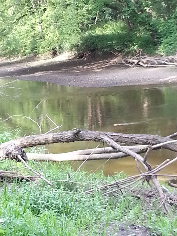
The otter is in the middle-right-hand segment of the image, immediately above the fallen tree. As documentation, I think this compares favorably with most images of Nessie.
After that brush with Nature, I looked at my watch and realized it was time to go. I hopped back on my bike, and pedaled doggedly East on Route 117, getting buzzed by some dude in a Mercedes convertible who was trying to impress his wife/girlfriend (does that really work?). Once in Concord, took the Lexington Road/Virginia Road/Mill Street/Lincoln Street/Middle Street/Marret Road shortcut home. Dodged a flock of turkeys (turkey, the new pigeon) at Hanscom Field. On Mill Street, my lower lip was impacted by a small gobbet of brown, amorphous material which I took to be caterpillar poop. On a more aesthetic note, I paused to admire a sunset vista on the Northern end of the Cambridge Reservoir, noting that the poison ivy in the foreground was changing colors, a harbinger of Autumn.

74 miles of dry, pleasant travel through Arlington, Lexington, Bedford, Concord, Sudbury, Maynard, Stow, Harvard, Bolton, Lancaster, and Lincoln, plus perhaps 20 feet of Devens. Could have spit into Boxboro, but didn't. 6562 ft of elevation gain, if the My Tracks app has it right.
rod
While Oxbow NWR does not permit bicycles beyond the access road and parking area, Google Maps suggested that Still River Depot Road continues beyond the Nashua River into Devens as Harvard Road. That, and the insidious operation of the Out Yonder bug, drew me down the steep hill on Still River Depot Road to Oxbow NWR.
Took a picture of the start of Tank Road, a candidate for an imaginary segment of the Nashua River Rail Trail ( Nashua River Tank Trail, in this case, looks like the railroad is still operating here). My bicycle, as well as my imaginary dog, feel excluded.
Nodding to the greater good of not disturbing critters, went looking for the Google-promised Harvard Road into Devens. Came to a beautiful, if somewhat funky, iron bridge across the Nashua River.
HOWEVER... rather than the Google-mapped thoroughfare into Devens, at the end of the bridge there was a gate that looked to have been INFORMALLY opened. Beyond this was a short, unmaintained trail, terminated by a locked gate.
Beyond that was the Google-assured Harvard Road. Although nothing was posted, between the locked gate and the sounds of gunfire (as previously reported by Jim, from his canoe, and characterized by my sweetie, when she heard them, as sounding like Chinese New Year), I made the reasonable inference that this was as far into Devens as the Bicycle Gods intended me to travel today, and I had another occasion to mutter, "Google Maps: Trust, but verify!" as I rode back up Still Water Depot Road, taking care to be on the look-out for Nighthawks.
After an interesting climb, headed South on Still River Road, enjoying the Harvard architecture, Saint Benedict's Abbey, and more views of Out Yonder. After a long, fast descent, I was approaching the Bolton line when I was smacked in the upper lip by a massive beetle with a spiked carapace. After a few blocks, I saw a fine pair of Lawn Flamingos. The tasteful, well-heeled Harvard gestalt was behind me, the occasional 18th-Century farmhouse notwithstanding. Somewhere to the West, I knew the Bolton Flats Wildlife Management Area lay, but couldn't see much of it through the trees. When I got to Route 117, I headed West, and got to see a bit of it looking North.
Continued on into Lancaster, a town I'd never been in. While heavily traveled, Route 117 there is a delight, with an aisle of mature trees shading the highway, and working fields on either side. That, and the flat, well-watered terrain, reminded me of East Anglia. Went as far as the Canoe Landing. Walked the bike down the trail to the river, where I saw an otter, which I attempted to photograph.
The otter is in the middle-right-hand segment of the image, immediately above the fallen tree. As documentation, I think this compares favorably with most images of Nessie.
After that brush with Nature, I looked at my watch and realized it was time to go. I hopped back on my bike, and pedaled doggedly East on Route 117, getting buzzed by some dude in a Mercedes convertible who was trying to impress his wife/girlfriend (does that really work?). Once in Concord, took the Lexington Road/Virginia Road/Mill Street/Lincoln Street/Middle Street/Marret Road shortcut home. Dodged a flock of turkeys (turkey, the new pigeon) at Hanscom Field. On Mill Street, my lower lip was impacted by a small gobbet of brown, amorphous material which I took to be caterpillar poop. On a more aesthetic note, I paused to admire a sunset vista on the Northern end of the Cambridge Reservoir, noting that the poison ivy in the foreground was changing colors, a harbinger of Autumn.
74 miles of dry, pleasant travel through Arlington, Lexington, Bedford, Concord, Sudbury, Maynard, Stow, Harvard, Bolton, Lancaster, and Lincoln, plus perhaps 20 feet of Devens. Could have spit into Boxboro, but didn't. 6562 ft of elevation gain, if the My Tracks app has it right.
rod
Last edited by rholland1951; 08-19-12 at 09:25 PM.
08-19-12, 03:26 PM
#2043
Senior Member
Join Date: Mar 2009
Location: Carlisle, MA
Posts: 209
Bikes: old Merlin, Santana Beyond, & a mommy bike
Mentioned: 0 Post(s)
Tagged: 0 Thread(s)
Quoted: 0 Post(s)
Likes: 0
Liked 0 Times
in
0 Posts
Love your posts, Rod!
I didn't ride today but while giving my eldest son a driving lesson, spotted Jim & Sharon on their tandem turning down Curve Street in Carlisle. Metro Boston ... what a small place indeed!
I didn't ride today but while giving my eldest son a driving lesson, spotted Jim & Sharon on their tandem
turning down Curve Street in Carlisle. Metro Boston ... what a small place indeed!
08-19-12, 03:51 PM
#2045
Senior Member
Thread Starter
Rod,
Beautiful photography and great, detailed ride. Congratulations on all accounts.
In contrast, I rode my familiar, very flat route Sherborn to Carlisle and back metric century more for the athletic challenge than observation and education. No diorama, out yonder flamingo or otter but, on the other hand, no caterpillar poop either.
08-19-12, 05:31 PM
#2047
What??? Only 2 wheels?
Join Date: Apr 2010
Location: Boston-ish, MA
Posts: 13,434
Bikes: 72 Peugeot UO-8, 82 Peugeot TH8, 87 Bianchi Brava, 76? Masi Grand Criterium, 74 Motobecane Champion Team, 86 & 77 Gazelle champion mondial, 81? Grandis, 82? Tommasini, 83 Peugeot PF10
Mentioned: 189 Post(s)
Tagged: 0 Thread(s)
Quoted: 1222 Post(s)
Liked 645 Times
in
232 Posts
Rod, your reports are always so fascinating! But, um, did you do this one on a bike or by canoe? Some of that looks familiar. We've canoed up past Lancaster from Still River. It's a wild place at times.
You should've waved! On the other hand, if it involved a driving lesson maybe it's better you stayed away.  Ah, Sharon says she thought somebody yelled "Hey!" On Curve St? That would likely have been on our return.
Good question. I want to know too.
You folks are posting such great pics. I have no great pics today, no grand and glorious vistas, no endless cornfields and picturesque river crossings. You have all already done that!
Just a trivial ride report, 46.8 miles on the tandem with my sweetie. Sharon wanted a long ride today. But our band played a show in Wolfeboro, NH last night so we got a late start today.
We went west from Bedford into Carlisle, then for some new roads for us further west into Westford and north into northern Chelmsford. Came into Chelmsford Center from the west. You know how Carlisle has a few hills? Well, Chelmsford has some too, only much longer. Drop into low gear and grind away... Did I mention how Chelmesford has a few hills? It was a good day! My sweetie has declared more than once how she likes riding the big chainring. So now she wants to be called Big Chainring Mama.
At Great Brook Farm on our return we met a couple riding a pair of beautiful Mercians. Spent some time talking old bikes with them. No pics, alas.
Stopping at a park on the northeast side of Chelmsford Center:

And the obligatory picnic, without which this ride would be pointless:

Ah, Sharon says she thought somebody yelled "Hey!" On Curve St? That would likely have been on our return.You folks are posting such great pics. I have no great pics today, no grand and glorious vistas, no endless cornfields and picturesque river crossings. You have all already done that!
Just a trivial ride report, 46.8 miles on the tandem with my sweetie. Sharon wanted a long ride today. But our band played a show in Wolfeboro, NH last night so we got a late start today.
We went west from Bedford into Carlisle, then for some new roads for us further west into Westford and north into northern Chelmsford. Came into Chelmsford Center from the west. You know how Carlisle has a few hills? Well, Chelmsford has some too, only much longer. Drop into low gear and grind away... Did I mention how Chelmesford has a few hills? It was a good day! My sweetie has declared more than once how she likes riding the big chainring. So now she wants to be called Big Chainring Mama.
At Great Brook Farm on our return we met a couple riding a pair of beautiful Mercians. Spent some time talking old bikes with them. No pics, alas.
Stopping at a park on the northeast side of Chelmsford Center:
And the obligatory picnic, without which this ride would be pointless:
__________________
Real cyclists use toe clips.
With great bikes comes great responsibility.
jimmuller
Real cyclists use toe clips.
With great bikes comes great responsibility.
jimmuller
08-19-12, 06:26 PM
#2048
Senior Member
Join Date: May 2011
Posts: 3,175
Mentioned: 15 Post(s)
Tagged: 0 Thread(s)
Quoted: 534 Post(s)
Liked 1,737 Times
in
890 Posts
rod
08-20-12, 10:19 AM
#2049
Senior Member
Thread Starter
Crossing I-90
https://www.mapmyride.com/routes/view/126832179
This is a Mapmyride link of my Sherborn-Carlisle loop.
I cross I-90 and Rt.30 by going north from Wellesley Center on Weston Rd, Turn west then north on Bogle then at Rivers School north on Winter St. over I-90.
It is Highland over Sanderson Hill into Weston Center, on up Concord Rd passed the Observatory becomes Tower Rd in Lincoln to Sandy Pond and Baker Bridge (Carroll School and Gropius House) to Rt.126 Concord Rd to Concord. I prefer Monument Rd on the way north and Lowell Rd on the way south. I was hardcore and didn't stop to liberate fig newtons at Ferns yesterday.
Refill water and down a handful of raisins in Concord Ctr. then take Sudbury Rd across Rt.2 passed Verrills Farm and Rt.117 and on Sudbury's Concord Rd to the LS High School, left or east on Lincoln Rd and south on Water Row, Old Sudbury, Glezen, Training Field, Claypit, Plain, Old CT Path, Rice and cross over I-90 on Oak St.
Turn east on Winter back to Rivers and retrace the route but follow Rt. 16, aka Eliot into Sherborn.
08-20-12, 12:17 PM
#2050
What??? Only 2 wheels?
Join Date: Apr 2010
Location: Boston-ish, MA
Posts: 13,434
Bikes: 72 Peugeot UO-8, 82 Peugeot TH8, 87 Bianchi Brava, 76? Masi Grand Criterium, 74 Motobecane Champion Team, 86 & 77 Gazelle champion mondial, 81? Grandis, 82? Tommasini, 83 Peugeot PF10
Mentioned: 189 Post(s)
Tagged: 0 Thread(s)
Quoted: 1222 Post(s)
Liked 645 Times
in
232 Posts
Thanks, SBP. Will have to study. (Frankly, I'm as much concerned with the Great Wall Of I-90 backup systems known as Rt9 and Rt30 and I am with the Great Wall itself. To someone who has been through there only by car, Natick seems to have its own complete defense perimeter.)
__________________
Real cyclists use toe clips.
With great bikes comes great responsibility.
jimmuller
Real cyclists use toe clips.
With great bikes comes great responsibility.
jimmuller