


Cycling Up the Rockies Route
 03-21-17, 05:26 AM
#1
Senior Member
Thread Starter
Join Date: Dec 2016
Posts: 98
Mentioned: 1 Post(s)
Tagged: 0 Thread(s)
Quoted: 71 Post(s)
Likes: 0
Liked 0 Times
in
0 Posts
Cycling Up the Rockies Route
This is just a rough idea of what we're doing with a time scale of six months. Does anyone have any knowledge of anything along the way? Any place we should avoid? Anyone want to meet up and do a section together? (: Cheers!
https://goo.gl/maps/7QQ66HeHJW92
https://goo.gl/maps/7QQ66HeHJW92
 03-21-17, 05:43 AM
#2

In Real Life

Join Date: Jan 2003
Location: Down under down under
Posts: 52,152
Bikes: Lots
Mentioned: 141 Post(s)
Tagged: 0 Thread(s)
Quoted: 3203 Post(s)
Liked 596 Times
in
329 Posts
I am quite familiar with much of the Alberta and BC sections of the route, and have cycled a bit in northern Montana too.
I spent most of my life living in various parts of Alberta, near the Canadian Rockies, and up north.
I've also spent quite a bit of time in southwestern BC, but have cycled through the middle of BC and in various other parts too.
What do you want to know?
I spent most of my life living in various parts of Alberta, near the Canadian Rockies, and up north.
I've also spent quite a bit of time in southwestern BC, but have cycled through the middle of BC and in various other parts too.
What do you want to know?
__________________
Rowan
My fave photo threads on BF
Century A Month Facebook Group
Machka's Website
Photo Gallery
Rowan
My fave photo threads on BF
Century A Month Facebook Group
Machka's Website
Photo Gallery


 03-21-17, 06:12 AM
#4
Mid Tour!

Join Date: Oct 2016
Location: Soon back in Edmonton Alberta
Posts: 569
Bikes: Marin Muirwoods Racked out for this years Tour, Norco Indi 4 racked out from last years tour, Giant Defi II for week-end ripps.
Mentioned: 2 Post(s)
Tagged: 0 Thread(s)
Quoted: 152 Post(s)
Likes: 0
Liked 4 Times
in
3 Posts
You may be more interested in Tyrell museum in Drumheller than Dinosaur Provincial park. Research each.
Hope this helps.
-Snuts-
Hope this helps.
-Snuts-
03-21-17, 11:15 AM
#5
Hooked on Touring
I have lived and cycled in Wyoming for 27 years.
I taught and cycled in Montana for many years.
I have bicycled the West and the Rockies, specifically.
From Arizona to the Yukon - with lots of dirt.
Googlemaps is not your friend.
People usually do not take kindly to me saying that.
But I have to assume - since you are from the UK -
And since your route has quiet a few impossibilities -
That you are not familiar with what kind of riding lays ahead.
Googlemaps can send you on private roads, on hiking-only trails,
Over bridges that no longer exist, even down imaginary roads.
In places like Hampshire or New Hampshire, its not a big deal.
But in the remote West, it is.
The problem with technology is that it makes everything seem accessible.
When it's not. And when it is very easy to get in over your head.
The people I know who work in the park service or forest service all say -
That the typical people who need rescue are those who overestimated their ability -
And who underestimated the degree of difficulty and distance from assistance.
(That includes lack of cell service and any electronic mapping.)
I'll mention a few points:
Wyoming
1. The trail from Jackson Lake Lodge to Colter Bay in Grand Teton N.P. is hiker only.
(Cycling off-road in most national parks is illegal and will result in citation.)
2. Uhl Hill Rd / Elk Ranch Road in the eastern part of the park is private, no trespassing.
(Most national parks have significant private inholdings - you need a park map to avoid trespass.)
3. Do you have any idea what you are up against in the Red Desert?
(Many of these roads are unmarked two-tracks that look alike and end up nowhere.)
Montana
1. I cannot understand your routing from E. Helena to Wolf Creek.
(Much of the routing is private - not to mention nearly impossible to ride.)
(Anyhoo, Helena is lovely, historic - and Recreation Road is a sweet ride along Prickly Pear Creek.)
2. PS - MT 434 from Wolf Creek is a really nice ride via Bean Lake to Augusta.
(Birdtail Cr. Rd. is legit, but MT 434 has no traffic, some dirt sections, and open views of the mtns.)
3. You cannot bike into the Belly River section of Glacier N.P. - even hiking requires advance permit.
(If you are going to take IR 464, then why not take in Many Glacier/Swiftcurrent? With incredible hikes.)
CrackerLake - Moderate hike out with backcountry overnight from Many Glacier
Last edited by jamawani; 03-21-17 at 12:24 PM.
03-21-17, 11:50 AM
#6
Senior Member
Thread Starter
Join Date: Dec 2016
Posts: 98
Mentioned: 1 Post(s)
Tagged: 0 Thread(s)
Quoted: 71 Post(s)
Likes: 0
Liked 0 Times
in
0 Posts
Googlemaps is not your friend...And since your route has quiet a few impossibilities -
That you are not familiar with what kind of riding lays ahead....That the typical people who need rescue are those who overestimated their ability - And who underestimated the degree of difficulty and distance from assistance. (That includes lack of cell service and any electronic mapping.)
That you are not familiar with what kind of riding lays ahead....That the typical people who need rescue are those who overestimated their ability - And who underestimated the degree of difficulty and distance from assistance. (That includes lack of cell service and any electronic mapping.)
I had a fair amount of medical problems that I constantly have to keep an eye on, so I'm a fairly good judge of my ability by now and Rob's more fit than I am so anything I'm okay with doing he probably will be as well. However, given there is always a possibility of something unplanned going wrong, we do have an emergency beacon we got a few years ago and is still in date. It works off a satellite so if we get into serious trouble, we can still call for help even without phone signal. We will also be keeping various friends and family updated every time we attempt to pass somewhere remote with details of how long they should expect to hear from us again. Hopefully one of them actually cares enough to do something if they don't hear from us when we said we would be in touch. XD
And though I didn't quote your points in Wyoming and Montana, thanks a ton for those and below is the reply to the points:
Wyoming
1. Do you know if bikes are allowed to ride on the Hwy 89 between those two points? Any park we come across we will research beforehand to find cycle specific routes, but have only researched as far as Bruce Canyon as I don't want to look too far in advance in case of weather or other need to reroute.
2. Same as above.
3. I know absolutely nothing about the Red Desert at this point. Any of the route past Bruce Canyon has not been researched other than: oh, that's pretty. I want to see that. As I research it closer to the dates and we decide it's not possible, then we won't do it and I'll just have to come back to visit one day with a car. XD However, I would love to see Independence Rock so do you think it would be possible if we made a route that stuck closer to the towns in that area? We don't mind putting a good few extra miles on; better tired and safe than dead.
Montana
1. Again, that's just how google routed it. I haven't actually planned that far yet. Helena was just one of the many points I wanted to visit as it looks stunning. (:
2. Thank you for this. Have starred both ends with notes so will remember to take it if we can.
3. I don't know which section of Glacier NP is the Belly River part, but is hiking permitted anywhere in Glacier NP? It just looked so pretty we wanted to visit. Will of course, get more accurate maps of the area when we're actually in Montana.
Also, are there any websites or apps you would recommend using for this trip?
And thank you so much for taking all of this time to help us out. (:
03-21-17, 12:01 PM
#7
Senior Member
Thread Starter
Join Date: Dec 2016
Posts: 98
Mentioned: 1 Post(s)
Tagged: 0 Thread(s)
Quoted: 71 Post(s)
Likes: 0
Liked 0 Times
in
0 Posts
I am quite familiar with much of the Alberta and BC sections of the route, and have cycled a bit in northern Montana too.
I spent most of my life living in various parts of Alberta, near the Canadian Rockies, and up north.
I've also spent quite a bit of time in southwestern BC, but have cycled through the middle of BC and in various other parts too.
What do you want to know?
I spent most of my life living in various parts of Alberta, near the Canadian Rockies, and up north.
I've also spent quite a bit of time in southwestern BC, but have cycled through the middle of BC and in various other parts too.
What do you want to know?
Thanks for all of this help you've been given the past few months. We're really just wanting to know what roads are actually good for cycling. I'm not too fond of cars, but we also aren't up for doing a lot of off-roading (atm anyway, this might change later when we get more experience). Also, if there's any really awesome places we should check out. We'd like to wild camp most of it, but I've heard this is fairly hard in Canada so if you have any experience or knowledge of this, that would be great. Oh, and do you know if we need to have bear spray or containers, etc to camp (either wild or at a campsite)?
03-21-17, 12:05 PM
#8
Senior Member
Thread Starter
Join Date: Dec 2016
Posts: 98
Mentioned: 1 Post(s)
Tagged: 0 Thread(s)
Quoted: 71 Post(s)
Likes: 0
Liked 0 Times
in
0 Posts
When you're on the Cassiar, at Meziadin Junction, take the Glacier Highway (37a) to Stewart and on to Hyder, AK. The mine road out of Hyder up to view the glacier is tough, but doable, and definitely worth it, IMO
03-21-17, 02:25 PM
#9
Hooked on Touring
Wrote a long response and it got eaten.
I looked at your map and your blog.
Help me, please. Are you flying into Las Vegas in two weeks ??
I would strongly advise you to look at the climate of the West. 4 things:
1. Winter stays late and returns early.
2. Temperatures can drop 45F/25C in just a few hours.
3. Temps drop on average 4F per 1000 feet. Thus, high elevation is colder still.
4. Wind. Wind, wind, and more wind.
Here are climate normal maps from Oregon State University Prism site:
PRISM Climate Group, Oregon State U
Look at April average high temps - below 50F/10C for much of the Intermountain West.
Here is an excellent detailed site, Western Regional Climate Center:
Western U.S. Climate Historical Summaries
Click on a state then a specific location to see climate history.
Las Vegas - April Avg - Hi 78F, Lo 52F, Precip 0.2 inch
Bryce Canyon - April Avg - Hi - 53F, Lo - 22F, Precip 0.7 inch (incl 6 inches of snow)
If you are getting into Vegas in early April -
You should really consider heading to Death Valley first - should have good wildflowers this year.
Then the Mojave Preserve, then Old Route 66 to Grand Canyon South Rim.
Even then, as you climb into higher territory in Arizona, the temps will drop.
You really shouldn't hit the Canadian border until about July 1.
The West has had a lot of snow this winter - 10 feet, 20 feet, and more.
Which takes a long time to melt out - esp. on unplowed roads and parks.
Snotel Map of snowpack:
Basin Snow Water Content Map (SNOTEL)
And there's likely to be more snow in the Northwest and Northern Rockies -
I would be more comfortable connecting thru P.M.
There are many things that are potential problems - not deathly - put still hard knocks.
Best - J
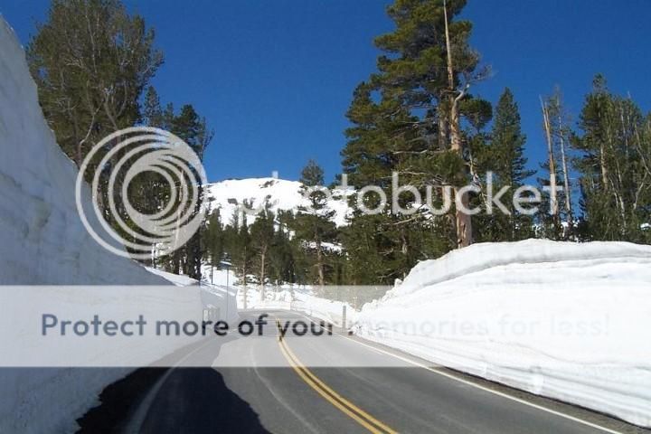
Sonora Pass, California - Last weekend in May
I looked at your map and your blog.
Help me, please. Are you flying into Las Vegas in two weeks ??
I would strongly advise you to look at the climate of the West. 4 things:
1. Winter stays late and returns early.
2. Temperatures can drop 45F/25C in just a few hours.
3. Temps drop on average 4F per 1000 feet. Thus, high elevation is colder still.
4. Wind. Wind, wind, and more wind.
Here are climate normal maps from Oregon State University Prism site:
PRISM Climate Group, Oregon State U
Look at April average high temps - below 50F/10C for much of the Intermountain West.
Here is an excellent detailed site, Western Regional Climate Center:
Western U.S. Climate Historical Summaries
Click on a state then a specific location to see climate history.
Las Vegas - April Avg - Hi 78F, Lo 52F, Precip 0.2 inch
Bryce Canyon - April Avg - Hi - 53F, Lo - 22F, Precip 0.7 inch (incl 6 inches of snow)
If you are getting into Vegas in early April -
You should really consider heading to Death Valley first - should have good wildflowers this year.
Then the Mojave Preserve, then Old Route 66 to Grand Canyon South Rim.
Even then, as you climb into higher territory in Arizona, the temps will drop.
You really shouldn't hit the Canadian border until about July 1.
The West has had a lot of snow this winter - 10 feet, 20 feet, and more.
Which takes a long time to melt out - esp. on unplowed roads and parks.
Snotel Map of snowpack:
Basin Snow Water Content Map (SNOTEL)
And there's likely to be more snow in the Northwest and Northern Rockies -
I would be more comfortable connecting thru P.M.
There are many things that are potential problems - not deathly - put still hard knocks.
Best - J
Sonora Pass, California - Last weekend in May
03-21-17, 03:13 PM
#10
Senior Member
Thread Starter
Join Date: Dec 2016
Posts: 98
Mentioned: 1 Post(s)
Tagged: 0 Thread(s)
Quoted: 71 Post(s)
Likes: 0
Liked 0 Times
in
0 Posts
I hate it when posts get eaten. Just happened to me earlier today. :/
And um, we're leaving this Saturday? I put a question mark because it doesn't really feel real yet...
We're already comfortably prepared for 0C nights (so 32F) and if we snuggle, can probably do a bit lower. I have a few medical problems so the cold is much better for me and I give off a ridiculous amount of heat, so 10C is the perfect temperature for me. It was 6C high today and I was out in shorts and a t-shirt (yes, I get a lot of looks during winter, but it's either that or get into a shaking/pain-overiding fit XD). However, thank you for the local knowledge and Rob also thanks you because it means he's won on the extra jackets argument. Haha.
Death valley sounds a bit intimidating...it's also in the wrong direction; same with the others. They might not seem like much for an experienced cyclists, but neither Rob nor I are experienced cyclists... Also, we're not entirely sure if we can make it to Canada in three months due to my medical problems and our lack of fitness, so we won't want to add much extra on until we can be sure we'll make it in time (Rob will be on a tourist visa - 3 months). We'll probably get a better estimate after a month and hopefully we'll be in northern Utah by then so if you have any suggestions for detours after that, we're all ears!
And thank you so much for all of the snow sites and other links. Will definitely bookmark them so we can keep updated with the current weather while on the road. And please feel free to shoot me a PM with any more tips. You've been incredibly helpful already. Thanks.
03-21-17, 03:40 PM
#11

BTW: The Cassiar is great! Do carry bear spray, you won't need it but it's a comfort to have. Be sure to carry bear spray that's approved for both US & Canada.
Last edited by BigAura; 03-21-17 at 04:04 PM.
03-21-17, 05:10 PM
#12
Senior Member
Thread Starter
Join Date: Dec 2016
Posts: 98
Mentioned: 1 Post(s)
Tagged: 0 Thread(s)
Quoted: 71 Post(s)
Likes: 0
Liked 0 Times
in
0 Posts
It's beautiful but not the standout that the mine-road is. Read the border crossing rules carefully to see if there's a way.
BTW: The Cassiar is great! Do carry bear spray, you won't need it but it's a comfort to have. Be sure to carry bear spray that's approved for both US & Canada.
BTW: The Cassiar is great! Do carry bear spray, you won't need it but it's a comfort to have. Be sure to carry bear spray that's approved for both US & Canada.
And will have to read the requirements for the bear spray. Thanks for letting me know they're different in both countries. Wouldn't happen to know which one's good to go with?
03-21-17, 05:30 PM
#13
At the border they confiscated my US (South Carolina) spray that had too much knock-down-power (3%)

Just checked here is the Canada legal spray. Not sure but now says 2%
Last edited by BigAura; 03-22-17 at 01:23 AM.
03-21-17, 08:54 PM
#14
Hooked on Touring
Here are three suggestions for the initial section -
1. Las Vegas to Zion
https://ridewithgps.com/routes/19720562
I would avoid unpaved roads in Nevada/Utah - sand! - esp. with a tandem.
20 miles on I-15 (Yuk, only option) Biking on Interstates in the West is legal, wide shoulder.
Lake Meade North Shore Rd and Old US Highway 91 are very nice.
You simply must do Zion in spring - stunningly beautiful.
Also, it's still moderately low and you can wait out any bad weather.
2. Zion to Capitol Reef
https://ridewithgps.com/routes/19721038
Bikes not permitted in Zion tunnel - catch a ride up the switchbacks and thru from campground.
The top of the Grand Staircase is 7000 to 8000 feet - and will be colder.
Bryce Canyon is certainly worth it - even if chilly.
Hwy 12 is one of the premier rides in Utah - magical.
Fruita in Capitol Reef is an oasis of green in huge red walls.
3. Capitol Reef to Nine Mile Canyon
https://ridewithgps.com/routes/19721109
Hwy 72/10 to Price is a direct shot with small towns along the way.
You may want the services that Price has to offer rather than taking the cutoff.
Nine Mile Canyon Road is mostly, if not entirely, paved, now.
But it is because of oil & gas exploration which means more traffic.
Fabulous ancient Native American art sites.
https://www.castlecountry.com/media/...untry-Utah.pdf
Campground - Nine Mile Ranch ? Your Destination for Discovery
Should I continue up to Dinosaur National Monument?
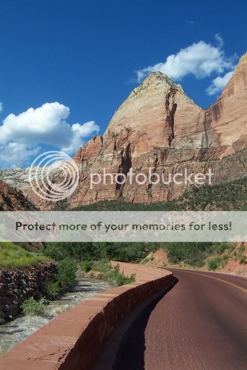
Pic - Zion Canyon
1. Las Vegas to Zion
https://ridewithgps.com/routes/19720562
I would avoid unpaved roads in Nevada/Utah - sand! - esp. with a tandem.
20 miles on I-15 (Yuk, only option) Biking on Interstates in the West is legal, wide shoulder.
Lake Meade North Shore Rd and Old US Highway 91 are very nice.
You simply must do Zion in spring - stunningly beautiful.
Also, it's still moderately low and you can wait out any bad weather.
2. Zion to Capitol Reef
https://ridewithgps.com/routes/19721038
Bikes not permitted in Zion tunnel - catch a ride up the switchbacks and thru from campground.
The top of the Grand Staircase is 7000 to 8000 feet - and will be colder.
Bryce Canyon is certainly worth it - even if chilly.
Hwy 12 is one of the premier rides in Utah - magical.
Fruita in Capitol Reef is an oasis of green in huge red walls.
3. Capitol Reef to Nine Mile Canyon
https://ridewithgps.com/routes/19721109
Hwy 72/10 to Price is a direct shot with small towns along the way.
You may want the services that Price has to offer rather than taking the cutoff.
Nine Mile Canyon Road is mostly, if not entirely, paved, now.
But it is because of oil & gas exploration which means more traffic.
Fabulous ancient Native American art sites.
https://www.castlecountry.com/media/...untry-Utah.pdf
Campground - Nine Mile Ranch ? Your Destination for Discovery
Should I continue up to Dinosaur National Monument?
Pic - Zion Canyon
Last edited by jamawani; 03-21-17 at 09:00 PM.
03-21-17, 10:30 PM
#15
In Real Life
Join Date: Jan 2003
Location: Down under down under
Posts: 52,152
Bikes: Lots
Mentioned: 141 Post(s)
Tagged: 0 Thread(s)
Quoted: 3203 Post(s)
Liked 596 Times
in
329 Posts
Hi Machka,
Thanks for all of this help you've been given the past few months. We're really just wanting to know what roads are actually good for cycling. I'm not too fond of cars, but we also aren't up for doing a lot of off-roading (atm anyway, this might change later when we get more experience). Also, if there's any really awesome places we should check out. We'd like to wild camp most of it, but I've heard this is fairly hard in Canada so if you have any experience or knowledge of this, that would be great. Oh, and do you know if we need to have bear spray or containers, etc to camp (either wild or at a campsite)?
Thanks for all of this help you've been given the past few months. We're really just wanting to know what roads are actually good for cycling. I'm not too fond of cars, but we also aren't up for doing a lot of off-roading (atm anyway, this might change later when we get more experience). Also, if there's any really awesome places we should check out. We'd like to wild camp most of it, but I've heard this is fairly hard in Canada so if you have any experience or knowledge of this, that would be great. Oh, and do you know if we need to have bear spray or containers, etc to camp (either wild or at a campsite)?
When you camp in designated campgrounds within the National Parks, there will usually be bear containers. That's one reason to camp there. Outside of National Parks, it would be worth learning how to cache your food and absolutely anything that has a scent (soap, shampoo, etc. etc.).
Also know that in the National Parks, everything is expensive.
I would second the recommendation to go to Tyrell museum in Drumheller.
Alberta an absolutely brilliant province to cycle in because almost all the roads have wide shoulders ... except Hwy Hwy 56 going north out of Drumheller. I would recommend avoiding that one. Used to be Hwy 9 was pretty bad, but I just did some street views and it appears they've improved it.
When I lived in northern Alberta, Hwy 40 was all gravel. I think it is paved all the way through now. Personally, I'd stay on Hwy 40 and avoid 734. Go into Grande Cache and Grande Prairie for supplies. I wouldn't avoid those places. You'll likely need supplies by the time you get there ... groceries at least.
I don't know what your timing is like going past Grande Prairie. Just know that you'll likely get your first snowfall of the season in early August ... there's usually one snowfall then, which melts a day or two later. Then the snow will start coming more frequently in September.
__________________
Rowan
My fave photo threads on BF
Century A Month Facebook Group
Machka's Website
Photo Gallery
Rowan
My fave photo threads on BF
Century A Month Facebook Group
Machka's Website
Photo Gallery
Last edited by Machka; 03-21-17 at 10:45 PM.
03-21-17, 11:18 PM
#16
Occam's Rotor
Join Date: Jul 2013
Posts: 7,248
Mentioned: 61 Post(s)
Tagged: 0 Thread(s)
Quoted: 2366 Post(s)
Liked 2,331 Times
in
1,164 Posts
I'm only casually following this thread, but this is fantastic advice. If you did this and nothing else for your entire trip, you would feel it was a complete success.
As for Dinosaur National Monument -- if you are into Paleontology, it is excellent. As for scenery, it is a bit second-rate. Also, check to make sure the main attraction is open -- there were some instability issues with the building a few years ago. (Edit: they fixed it and reopened it in 2011).
As for Dinosaur National Monument -- if you are into Paleontology, it is excellent. As for scenery, it is a bit second-rate. Also, check to make sure the main attraction is open -- there were some instability issues with the building a few years ago. (Edit: they fixed it and reopened it in 2011).
Last edited by Cyclist0108; 03-21-17 at 11:25 PM.
03-22-17, 05:31 AM
#17
Senior Member
Thread Starter
Join Date: Dec 2016
Posts: 98
Mentioned: 1 Post(s)
Tagged: 0 Thread(s)
Quoted: 71 Post(s)
Likes: 0
Liked 0 Times
in
0 Posts
I absolutely love dinosaurs. Even went fossil hunting in Australia and brought back a few pieces (it's allowed in a place near Richmond). They don't look like much to people who don't know what they are, but dinosaur poop is like the easiest to recognize so got a lot of that. I also like visiting places even if you can't take fossils so not just going to steal any, don't worry. However, will definitely check out the museum as well if we can afford the entry fee. We've budgeted �500/month for the both of us so it might be a bit tight.
And thanks for all of the other suggestions on route. However, I'm pretty sure the road up from Mesquite is all paved, but I only followed it up to the border so not entirely sure. Will double check that before we do it.
And yes, please continue with any other recommendations! Scenery, wildlife, weird festivals, oddities, free museums or other attractions (or really good plane or dinosaur ones), hot springs, free camps, great places to view the stars, or anything else would be much appreciated. (:
Last edited by Mri G.; 03-22-17 at 05:35 AM.
03-22-17, 11:21 AM
#18
Occam's Rotor
Join Date: Jul 2013
Posts: 7,248
Mentioned: 61 Post(s)
Tagged: 0 Thread(s)
Quoted: 2366 Post(s)
Liked 2,331 Times
in
1,164 Posts
In that case you should go to Dinosaur Nat'l Monument, as well as the museum in town in Vernal. Price, Utah also has a museum worth seeing, if you are in the area. Admission to most museums like this is not expensive.
03-23-17, 04:18 AM
#19
Senior Member
Thread Starter
Join Date: Dec 2016
Posts: 98
Mentioned: 1 Post(s)
Tagged: 0 Thread(s)
Quoted: 71 Post(s)
Likes: 0
Liked 0 Times
in
0 Posts
The one other people mentioned is $18 each so at $36 we could feed ourselves for a week. However, if we visited one only every so often I think we should be okay, but I like having emergency cash if need be.
03-23-17, 12:42 PM
#20
cyclotourist
Join Date: Jul 2002
Location: calgary, canada
Posts: 1,470
Mentioned: 2 Post(s)
Tagged: 0 Thread(s)
Quoted: 443 Post(s)
Liked 205 Times
in
130 Posts
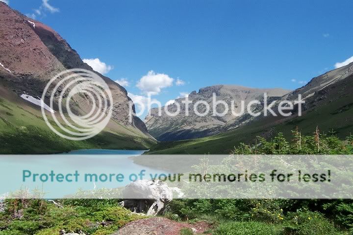
My suggestions for your route, are to definitely cycle the Going to the Sun road in Glacier Park, Montana. Coming from the south you should take the #89 from Browning and you could cross over the divide at Marias Pass, go to West Glacier and then up the west side of Going to the Sun. It is a not to be missed ride, either from the east or the west. You could just do it as an out and back up the east side from St. Mary.
If you decide to the skip the Canadian badlands at Dinosaur Provincial Park, I would recommend going to Waterton Lakes National Park, then up to the #3, west until #22 and north along the foothills, through ranching country, to Longview , and then west and North on Highway 40, over Highwood Pass, the highest paved road in Canada (but not a tough climb). It joins the #1 Trans Canada , east of Canmore and you could rejoin your original route. Itis a great road for cycling, not a lot of traffic, except for weekends.
Keep us appraised of your plans or send me a PM for further information.
03-23-17, 12:58 PM
#21
Hooked on Touring
Do NOT attempt to follow the route you have posted in southern Wyoming.
I believe you have just picked lines on a map and you have no idea what you are getting into.
Even for experienced Wyomingites, the Red Desert is a vast space in which to get lost.
Furthermore, in spring it can change from sunny to a blizzard rapidly.
Not to mention that various soil types often turn to sticky goo after rains.
03-23-17, 01:21 PM
#22
Senior Member
Join Date: Sep 2015
Location: Left Coast, Canada
Posts: 5,126
Mentioned: 24 Post(s)
Tagged: 0 Thread(s)
Quoted: 2236 Post(s)
Liked 1,314 Times
in
707 Posts
I'm also curious why you are bypassing all of the Canadian Rockies? The route from Calgary est to Lake Louise and up the Icefield Parkway to Jasper is world class touring.
I just rode the prairies and, while they are nice in their own way, there is no comparison.
I just rode the prairies and, while they are nice in their own way, there is no comparison.
03-23-17, 01:27 PM
#23
Senior Member
Join Date: Jan 2010
Posts: 39,229
Mentioned: 211 Post(s)
Tagged: 1 Thread(s)
Quoted: 18409 Post(s)
Liked 15,517 Times
in
7,324 Posts
03-23-17, 01:41 PM
#24
cyclotourist
Join Date: Jul 2002
Location: calgary, canada
Posts: 1,470
Mentioned: 2 Post(s)
Tagged: 0 Thread(s)
Quoted: 443 Post(s)
Liked 205 Times
in
130 Posts
??? They aren't bypassing the Rockies. Their route shows them going from Dinosaur Provincial Park, near Brooks Ab to Banff via the TCH and then up the Icefields Parkway.
I am recommending an alternative up the foothills and then the Kananaskis along Highway 40, which is beautiful scenery on an excellent road.
Dinosaur Provincial Park is okay, but I think they will find it a bit dull after places in Utah and Colorado. Many days of slogging across the prairies to get there. The Tyrrell museum near Drumheller is worth visiting, but is out of their budget, although I think they will be shocked by food prices in Canada anyway.
03-23-17, 02:31 PM
#25
Mad bike riding scientist

Join Date: Nov 2004
Location: Denver, CO
Posts: 27,352
Bikes: Some silver ones, a red one, a black and orange one, and a few titanium ones
Mentioned: 152 Post(s)
Tagged: 1 Thread(s)
Quoted: 6210 Post(s)
Liked 4,210 Times
in
2,360 Posts
As for Dinosaur National Monument -- if you are into Paleontology, it is excellent. As for scenery, it is a bit second-rate. Also, check to make sure the main attraction is open -- there were some instability issues with the building a few years ago. (Edit: they fixed it and reopened it in 2011).
Just around the bend from the quarry is Split Mountain


About 5 miles down the road is some of the most unique petroglyphs in the west. These are lizard petroglyphs which are very rare

and very large

Further up the road is the Josie Morris Cabin, the Box Canyon and breathtaking high desert views


__________________
Stuart Black
Plan Epsilon Around Lake Michigan in the era of Covid
Old School�When It Wasn�t Ancient bikepacking
Gold Fever Three days of dirt in Colorado
Pokin' around the Poconos A cold ride around Lake Erie
Dinosaurs in Colorado A mountain bike guide to the Purgatory Canyon dinosaur trackway
Solo Without Pie. The search for pie in the Midwest.
Picking the Scablands. Washington and Oregon, 2005. Pie and spiders on the Columbia River!
