


Las Vegas to Grand Canyon's North rim (next may - routing advice)
 06-07-17, 08:08 AM
#1
Senior Member
Thread Starter
Join Date: Sep 2015
Location: QC Canada
Posts: 1,971
Bikes: Custom built LHT & Troll
Mentioned: 12 Post(s)
Tagged: 0 Thread(s)
Quoted: 846 Post(s)
Liked 149 Times
in
106 Posts
Las Vegas to Grand Canyon's North rim (next May - routing advice)
So yes, Las Vegas to Grand Canyon' North rim is a definite candidate for our Spring trip (2 weeks + adjacent few days, without kids).
Google maps would suggest to ride a half circle on what appears to be secondary roads. If you've traveled them, please let me know how (un) pleasant your experience was.
MapQuest suggests what looks like a very interesting route, almost a straight line east of Mesquite. Not clear, however, if we can find supplies or even water.
I've attached pictures. Any suggestion appreciated.
MapQuest route
GMAPS routing
Last edited by gauvins; 06-07-17 at 08:16 AM.
 06-07-17, 08:29 AM
#2

Hooked on Touring
Google is not your friend. MapQuest is definitely not.
Not sure when you wish to do this or how many dirt roads you are willing to do.
Unless you are willing to do a remote quasi-wilderness ride will all supplies on board,
then the MapQuest is completely out of the question. The Google ride is on pavement.
There are no reasonable paved options out of Las Vegas to the northeast that do not include long stretches of riding on Interstate highways. If you are taking your own bikes, I would suggest shipping them to a bike shop in St. George and then catching a bus up to St. George. From St. George the riding options are many - and all pretty darn good.
*** When you say spring, you need to know that the North Rim does not open until May and that lots of higher elevations have significant winter snow. If you are planning an earlier trip, you will need to visit the South Rim via a totally different route. If early spring, Death Valley would be better.
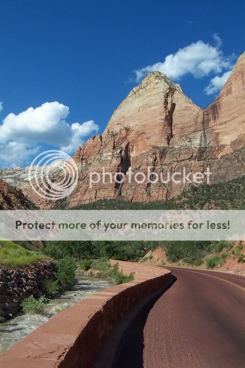
Pic - Zion N.P. just east of St. George
Not sure when you wish to do this or how many dirt roads you are willing to do.
Unless you are willing to do a remote quasi-wilderness ride will all supplies on board,
then the MapQuest is completely out of the question. The Google ride is on pavement.
There are no reasonable paved options out of Las Vegas to the northeast that do not include long stretches of riding on Interstate highways. If you are taking your own bikes, I would suggest shipping them to a bike shop in St. George and then catching a bus up to St. George. From St. George the riding options are many - and all pretty darn good.
*** When you say spring, you need to know that the North Rim does not open until May and that lots of higher elevations have significant winter snow. If you are planning an earlier trip, you will need to visit the South Rim via a totally different route. If early spring, Death Valley would be better.
Pic - Zion N.P. just east of St. George
06-07-17, 10:57 AM
#3
Upgrading my engine
Join Date: Aug 2004
Location: Alamogordo
Posts: 6,218
Mentioned: 5 Post(s)
Tagged: 0 Thread(s)
Quoted: 125 Post(s)
Likes: 0
Liked 0 Times
in
0 Posts
Not sure how far is too far, but I'd do something like this: https://goo.gl/maps/ht93xEUXw562
I've ridden that stretch from Crystal Springs, NV to Kanab, UT (petoji.blogspot.com), which was a good route.
The one thing I'd be worried about is the stretch from Coyote Springs, NV to Crystal Springs, NV on 93. I was actually considering a route from Yuma to Kalispell, but that portion was one of the main reasons I decided to ride from El Paso to the ND border instead.
06-07-17, 12:03 PM
#4
Senior Member
Join Date: Dec 2010
Location: Above ground, Walnut Creek, Ca
Posts: 6,681
Bikes: 8 ss bikes, 1 5-speed touring bike
Mentioned: 0 Post(s)
Tagged: 0 Thread(s)
Quoted: 86 Post(s)
Likes: 0
Liked 4 Times
in
4 Posts
So yes, Las Vegas to Grand Canyon' North rim is a definite candidate for our Spring trip (2 weeks + adjacent few days, without kids).
Google maps would suggest to ride a half circle on what appears to be secondary roads. If you've traveled them, please let me know how (un) pleasant your experience was.
MapQuest suggests what looks like a very interesting route, almost a straight line east of Mesquite. Not clear, however, if we can find supplies or even water.
I've attached pictures. Any suggestion appreciated.
MapQuest route
GMAPS routing
Google maps would suggest to ride a half circle on what appears to be secondary roads. If you've traveled them, please let me know how (un) pleasant your experience was.
MapQuest suggests what looks like a very interesting route, almost a straight line east of Mesquite. Not clear, however, if we can find supplies or even water.
I've attached pictures. Any suggestion appreciated.
MapQuest route
GMAPS routing
06-08-17, 07:05 PM
#5
deleteme
Join Date: Feb 2008
Location: PNW lifer
Posts: 582
Bikes: deleteme
Mentioned: 0 Post(s)
Tagged: 0 Thread(s)
Quoted: 50 Post(s)
Likes: 0
Liked 2 Times
in
2 Posts
When you say spring, you need to know that the North Rim does not open until May.
Oh contraire.
Technical Rules when I did it the third week in April during a historically low snow year:
#1. The road is OPEN to non moterized traffic. Get freaky on your xc skis, bike, rollerblades or sneakers.
#2. You can't camp at the north rim off season without a permit. Available at the South rim and supposedly at other locations.
#3. No bikes on the trails inside the north rim.
It is very cold at night on that plateau.
The ride down from Jacobs lake to Fredonia is scary. Heck, the ride up is scary too.... I've done both.
Funny tid bit of info. The cell towers were active at the North rim lodge.
EDIT: Riding from Mesquite to Vegas is uggghh. I've gotten rides back to Vegas from the Paiute truck stop located at the valley of fire freeway entrance and mesquite. Valley of Fire is interesting and only $1 to get in with a bike. Remember spring winds in that area of the US can create no go days it also can make for a 20+mph day schlepping 45lbs of gear on a gravel bike.
Last edited by escii_35; 06-09-17 at 04:59 PM.
06-14-17, 05:05 PM
#6
Junior Member
Join Date: May 2017
Location: Davis, CA
Posts: 19
Mentioned: 0 Post(s)
Tagged: 0 Thread(s)
Quoted: 7 Post(s)
Likes: 0
Liked 0 Times
in
0 Posts
Just a few comments.
1. I would definitely try to put Zion NP along your route. It would be a good stopping point, and I would imagine biking through the main canyon there would be great. They don't allow private vehicles (I would think they'd allow bikes). It would make a nice day break from touring with some decent scenery.
2. That pass referred to for Cedar Breaks is more likely to be closed than even the North Rim. I've only traveled in Utah in May (twice), and each time that pass was the only place I ran into that wasn't open due to snow.
I wish I could give feedback on the stretch from Vegas to St. George. That looks to be a challenge for little reward. I'd almost rather start in St. George and utilize the saved time to visit Bryce Canyon. That's also near 10,000 ft elevation, but the National Park Service seems to do a good job of keeping the road into there and the park open year round.
Anyway, good luck, and kudos to you for planning out ahead. By time you're ready to go, I'm sure you'll have it all figured out. It's actually a good time to go to that area since it can be quite hot if you went any later.
And, May is really too late to go to Death Valley. Spring in Death Valley is February maybe March. I went there last November and it was still 100-degrees in the day and 75 at night. That's not typical, but it apparently happens.
06-15-17, 04:59 AM
#8
Senior Member
Join Date: Feb 2005
Location: Tucker, GA USA
Posts: 133
Mentioned: 2 Post(s)
Tagged: 0 Thread(s)
Quoted: 19 Post(s)
Likes: 0
Liked 0 Times
in
0 Posts
Correct, bicycles are not permitted in the long tunnel. I've read of many touring cyclists hitching a ride through the tunnel. Also the park road, a dead end road up the Virgin River valley in the park is only open to private vehicles in winter and is a wonderful ride. The rest of the time there are free Park buses but bike are allowed. when my wife and I were there, I put our bikes on the Park bus to the end and basically coasted back. The scenery is great.
06-15-17, 05:59 AM
#9
Senior Member
Join Date: Jan 2010
Posts: 39,238
Mentioned: 211 Post(s)
Tagged: 1 Thread(s)
Quoted: 18415 Post(s)
Liked 15,545 Times
in
7,329 Posts
Cyclist hurt in dark Zion National Park tunnel | The Salt Lake Tribune
06-15-17, 06:27 AM
#10
Senior Member
don't know about nighttime....
ranger dudes will assist getting a ride, as in asking folks driving through if they'd
mind toting a cyclist through the tunnel.
06-16-17, 01:30 PM
#11
Junior Member
Join Date: May 2017
Location: Davis, CA
Posts: 19
Mentioned: 0 Post(s)
Tagged: 0 Thread(s)
Quoted: 7 Post(s)
Likes: 0
Liked 0 Times
in
0 Posts
The tunnel is over a mile if I recall and not lit. It's not exactly a safe set up. But I think it's fairly easy to hitch a ride through it. I even recall seeing a ranger help some tourers out. The tunnel is really close to the main village, headquarters, area, so it shouldn't be too travelling to get a ride.
In May, the main canyon road is closed, only open to shuttle buses and bikes. You won't have to worry about that route. It's a relatively short route, which is good. It's worth traveling that road and getting off the bike here and there and hiking a bit for the different sites.
In May, the main canyon road is closed, only open to shuttle buses and bikes. You won't have to worry about that route. It's a relatively short route, which is good. It's worth traveling that road and getting off the bike here and there and hiking a bit for the different sites.

Thread
Thread Starter
Forum
Replies
Last Post
trigger
Western Canada
7
07-02-13 12:28 AM
