


help with natchez trace parkway
 02-06-10, 09:35 PM
#1
Senior Member
Thread Starter
Join Date: Mar 2009
Posts: 63
Mentioned: 0 Post(s)
Tagged: 0 Thread(s)
Quoted: 1 Post(s)
Likes: 0
Liked 0 Times
in
0 Posts
help with natchez trace parkway
thinking of riding the natchez parkway this spring and looking for some information. has anyone used the Bus Terminal Charters for transportion along the trail? it says they have a shuttle service for bikers. what have other riders used for getting back from one end of trail to the other? also has anyone tried using part of the Mississippi River Trail for the return trip? i realize it runs west of the Natchez but could part of it be used for a round trip? any help welcomed!
 02-06-10, 10:13 PM
#2
Senior Member

Join Date: Jan 2007
Location: NE Tx
Posts: 2,766
Bikes: Tour Easy, Linear USS, Lightening Thunderbolt, custom DF, Raleigh hybrid, Felt time trial
Mentioned: 0 Post(s)
Tagged: 0 Thread(s)
Quoted: 0 Post(s)
Likes: 0
Liked 0 Times
in
0 Posts
All I can help you with is that the bridge over the Mississippi at Natchez is nothing I would tackle on a bicycle. No shoulder and very busy. There is a walking ledge but not wide enough for bike and person. You might could hitch a ride across.
The Trace is very smooth tarmac with mild grades. 440 miles of few services, quite forest, and light traffic. Nothing to see much unless you exit. Great road to use for loop rides to either side. Easy stealth camping, tho it may be illegal. Just heard it was. Never saw any signage to the effect and nothing at the official website.
The Trace is very smooth tarmac with mild grades. 440 miles of few services, quite forest, and light traffic. Nothing to see much unless you exit. Great road to use for loop rides to either side. Easy stealth camping, tho it may be illegal. Just heard it was. Never saw any signage to the effect and nothing at the official website.
02-06-10, 11:32 PM
#3
Senior Member

Join Date: Aug 2005
Posts: 3,872
Mentioned: 14 Post(s)
Tagged: 0 Thread(s)
Quoted: 598 Post(s)
Liked 283 Times
in
194 Posts
Another question, is the prevailing wind mostly from the south, say in late April or early May? Just wondering if anyone has rented a vehicle one-way to or from Nashville if the charter bus thing isn't available. As always, thanks for your input.
02-07-10, 05:37 AM
#4
Senior Member
Join Date: Apr 2009
Posts: 293
Mentioned: 0 Post(s)
Tagged: 0 Thread(s)
Quoted: 4 Post(s)
Likes: 0
Liked 0 Times
in
0 Posts
Stealth camping on the parkway is illegal. That being said, it isn't patrolled much at all, and there is almost no traffic after dark, so as long as there is some vegetation between you and the road you are fine. The old trace intersects the road frequently, and provides a good way to get some distance off the parkway without crashing through bushes.
02-09-10, 08:40 AM
#5

I am not a car

Join Date: May 2004
Location: Decatur, GA
Posts: 747
Bikes: Giant Revel 1, Surly Ogre
Mentioned: 0 Post(s)
Tagged: 0 Thread(s)
Quoted: 0 Post(s)
Likes: 0
Liked 1 Time
in
1 Post
I have this book and it might provide some answers to your questions: Bicycling the Natchez Trace: A Guide to the Natchez Trace Parkway and Nearby Scenic Routes (Paperback)
(No connection with author or book publishing--just seemed like a well-written book)
(No connection with author or book publishing--just seemed like a well-written book)
__________________
"Bad facts make bad laws." FZ
"Bad facts make bad laws." FZ
02-09-10, 09:00 AM
#6
Senior Member
Thread Starter
Join Date: Mar 2009
Posts: 63
Mentioned: 0 Post(s)
Tagged: 0 Thread(s)
Quoted: 1 Post(s)
Likes: 0
Liked 0 Times
in
0 Posts
their is plenty of information on the Natchez on the internet but no real information on returning to the starting point of your trip.
If anyone is planning on doing the trip from Natchez to Nashiville some time around April please let me know. Maybe we can arrange a car exchange for both are returns? You ride one direction and then drive the car back. Works for me and hopefully you.
If anyone is planning on doing the trip from Natchez to Nashiville some time around April please let me know. Maybe we can arrange a car exchange for both are returns? You ride one direction and then drive the car back. Works for me and hopefully you.
02-09-10, 04:33 PM
#7
Senior Member
I rode from Nashville to just past Jackson, MS on the Trace as part of a larger tour this fall. Loved it. Stealth camping is really easy as there is essentially no habitation within eyesight of most of the Trace. There are also several free campgrounds along the route, so I never found the need to stealth camp. Pick up one of the great free maps provided by the park service at all the stops. It seemed like there was a little historical stop of some kind every 5 miles. Also, stop to eat in French Camp, MS, the cafe there had excellent food and people.
Sorry I can't really help you with transportation. Have you looked into Greyhound or Amtrak? I had several friends take the bus from Natchez to New Orleans when they were finished.
Sorry I can't really help you with transportation. Have you looked into Greyhound or Amtrak? I had several friends take the bus from Natchez to New Orleans when they were finished.
02-09-10, 06:47 PM
#9
Senior Member

Join Date: May 2009
Location: North Georgia
Posts: 307
Bikes: Cervelo Soloist, Giant TCR Advanced, Co-Motion Americano Co-Pilot
Mentioned: 0 Post(s)
Tagged: 0 Thread(s)
Quoted: 0 Post(s)
Likes: 0
Liked 0 Times
in
0 Posts
Pay attention to your food and water. I ran out of water in 90+ degree weather while rising to Natchez and it got pretty testy. I found VERY limited services on the Trace- so my advice is fill the water bottles every chance you get.
BTW, I got to ride my bike across that Mississippi River bridge in Natchez before it was open to vehicles. Had the entire bridge to myself- very cool.
BTW, I got to ride my bike across that Mississippi River bridge in Natchez before it was open to vehicles. Had the entire bridge to myself- very cool.
Last edited by bobframe; 02-09-10 at 07:47 PM.
02-09-10, 06:58 PM
#10
Senior Member
 02-09-10, 09:10 PM
#11
Junior Member
Join Date: May 2009
Posts: 10
Mentioned: 0 Post(s)
Tagged: 0 Thread(s)
Quoted: 0 Post(s)
Likes: 0
Liked 0 Times
in
0 Posts
I just did the Natchez Trace about a month ago.
Just wanted to add that the bridge over the Mississippi at Natchez is very doable. There are two bridges... the westbound bridge is the old one with no shoulder. The eastbound bridge is new and has a wide shoulder. If you don't mind riding against traffic for a bit it's no problem:

Just wanted to add that the bridge over the Mississippi at Natchez is very doable. There are two bridges... the westbound bridge is the old one with no shoulder. The eastbound bridge is new and has a wide shoulder. If you don't mind riding against traffic for a bit it's no problem:
02-09-10, 09:20 PM
#12
bicycle tourist
02-10-10, 08:09 AM
#13
Senior Member
Join Date: May 2009
Location: North Georgia
Posts: 307
Bikes: Cervelo Soloist, Giant TCR Advanced, Co-Motion Americano Co-Pilot
Mentioned: 0 Post(s)
Tagged: 0 Thread(s)
Quoted: 0 Post(s)
Likes: 0
Liked 0 Times
in
0 Posts
I just did the Natchez Trace about a month ago.
Just wanted to add that the bridge over the Mississippi at Natchez is very doable. There are two bridges... the westbound bridge is the old one with no shoulder. The eastbound bridge is new and has a wide shoulder. If you don't mind riding against traffic for a bit it's no problem:
Just wanted to add that the bridge over the Mississippi at Natchez is very doable. There are two bridges... the westbound bridge is the old one with no shoulder. The eastbound bridge is new and has a wide shoulder. If you don't mind riding against traffic for a bit it's no problem:
02-10-10, 11:50 AM
#14
Senior Member
Join Date: Aug 2005
Posts: 3,872
Mentioned: 14 Post(s)
Tagged: 0 Thread(s)
Quoted: 598 Post(s)
Liked 283 Times
in
194 Posts
Joel2,
Natchez Enterprise rental would rent a truck for one way to Nashville for about $335 for the 530 miles. A few people would make it more reasonable.
Natchez Enterprise rental would rent a truck for one way to Nashville for about $335 for the 530 miles. A few people would make it more reasonable.
03-16-10, 11:30 AM
#15
(this space for rent)

Join Date: Mar 2008
Location: White Bluff, TN
Posts: 411
Bikes: 2018 Synapse Dura-Ace, 1995 Specialized M2-pro, 1995 Gary Fisher Montare
Mentioned: 0 Post(s)
Tagged: 0 Thread(s)
Quoted: 0 Post(s)
Likes: 0
Liked 4 Times
in
3 Posts
I have this book and it might provide some answers to your questions: Bicycling the Natchez Trace: A Guide to the Natchez Trace Parkway and Nearby Scenic Routes (Paperback)
(No connection with author or book publishing--just seemed like a well-written book)
(No connection with author or book publishing--just seemed like a well-written book)
01-20-11, 09:32 AM
#16
(this space for rent)
Join Date: Mar 2008
Location: White Bluff, TN
Posts: 411
Bikes: 2018 Synapse Dura-Ace, 1995 Specialized M2-pro, 1995 Gary Fisher Montare
Mentioned: 0 Post(s)
Tagged: 0 Thread(s)
Quoted: 0 Post(s)
Likes: 0
Liked 4 Times
in
3 Posts
Looks like I might try to do this ride first week in June, south to north, though I need to sort out how I'm to get down there, since it's a bit of a haul for ths Mrs to drop me off...
01-20-11, 12:07 PM
#17
Junior Member
Join Date: Jan 2011
Posts: 19
Mentioned: 0 Post(s)
Tagged: 0 Thread(s)
Quoted: 0 Post(s)
Likes: 0
Liked 0 Times
in
0 Posts
+1 to Bicycling the Natchez Trace: A Guide to the Natchez Trace Parkway and Nearby Scenic Routes (Paperback).
I went to the Natchez Trace Park website and submitted my name and address for more information. I received a very nice trail map along with some good information regarding stops and lodging, was very much worth the price, free.
I was planning to ride south to north in 2nd week of march but due to a pothole and a nasty endo I had to have my shoulder surgically repaired (Gr. 4 AC sep.) and don't think I'll be healed enough to go.
Good luck on your ride!
01-20-11, 01:08 PM
#18

Mad bike riding scientist

Join Date: Nov 2004
Location: Denver, CO
Posts: 27,362
Bikes: Some silver ones, a red one, a black and orange one, and a few titanium ones
Mentioned: 152 Post(s)
Tagged: 1 Thread(s)
Quoted: 6219 Post(s)
Liked 4,218 Times
in
2,365 Posts
+1 to Bicycling the Natchez Trace: A Guide to the Natchez Trace Parkway and Nearby Scenic Routes (Paperback).
I went to the Natchez Trace Park website and submitted my name and address for more information. I received a very nice trail map along with some good information regarding stops and lodging, was very much worth the price, free.
I was planning to ride south to north in 2nd week of march but due to a pothole and a nasty endo I had to have my shoulder surgically repaired (Gr. 4 AC sep.) and don't think I'll be healed enough to go.
Good luck on your ride!
I went to the Natchez Trace Park website and submitted my name and address for more information. I received a very nice trail map along with some good information regarding stops and lodging, was very much worth the price, free.
I was planning to ride south to north in 2nd week of march but due to a pothole and a nasty endo I had to have my shoulder surgically repaired (Gr. 4 AC sep.) and don't think I'll be healed enough to go.
Good luck on your ride!

This is a dense forest
You can see what my problem with trees might be

__________________
Stuart Black
Plan Epsilon Around Lake Michigan in the era of Covid
Old School�When It Wasn�t Ancient bikepacking
Gold Fever Three days of dirt in Colorado
Pokin' around the Poconos A cold ride around Lake Erie
Dinosaurs in Colorado A mountain bike guide to the Purgatory Canyon dinosaur trackway
Solo Without Pie. The search for pie in the Midwest.
Picking the Scablands. Washington and Oregon, 2005. Pie and spiders on the Columbia River!
01-20-11, 02:16 PM
#19
Which bike should I ride?

Join Date: Apr 2006
Location: Tuscaloosa, AL
Posts: 288
Mentioned: 0 Post(s)
Tagged: 0 Thread(s)
Quoted: 0 Post(s)
Likes: 0
Liked 2 Times
in
1 Post
+1 again on the Warner book. I've ridden parts of the Trace a number of times, and rode the entire length (south to north) 3 yr ago. Winds are generally from the south. Lots of chip seal pavement these days as the NPS is getting cutbacks just like everyone else. Light traffic for the most part, but watch yourself in the areas around Tupelo and Jackson MS. The Trace is used as a commute route by lots of folks in those areas. I did a credit card tour, staying in motels and B/Bs, so I can't comment on camping.
01-20-11, 11:04 PM
#20
Saved by Grace

Join Date: Dec 2010
Location: The slow guy in the back
Posts: 740
Bikes: Only one at a time; currently a 2012 Specialized Tricross Sport
Mentioned: 0 Post(s)
Tagged: 0 Thread(s)
Quoted: 1 Post(s)
Likes: 0
Liked 0 Times
in
0 Posts
But, the comment upthread about the little restaurant in French Camp is dead on. It's called the Council House Restaurant, part of French Camp Academy. Recommended.
01-21-11, 11:55 PM
#21
Mad bike riding scientist
Join Date: Nov 2004
Location: Denver, CO
Posts: 27,362
Bikes: Some silver ones, a red one, a black and orange one, and a few titanium ones
Mentioned: 152 Post(s)
Tagged: 1 Thread(s)
Quoted: 6219 Post(s)
Liked 4,218 Times
in
2,365 Posts
Well, I'm from Louisiana, where it's either swamp or dense pine forest and I can understand your tedium with the Trace. I've driven parts of it more than once and it's nice for a while, but what I've seen is all very much alike - Little variety.
But, the comment upthread about the little restaurant in French Camp is dead on. It's called the Council House Restaurant, part of French Camp Academy. Recommended.
But, the comment upthread about the little restaurant in French Camp is dead on. It's called the Council House Restaurant, part of French Camp Academy. Recommended.
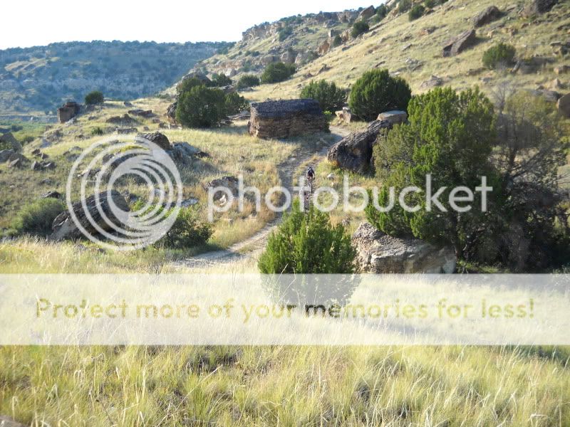
By the way in the middle of that picture is an American Pronghorn

She's running at about 40 mph.
__________________
Stuart Black
Plan Epsilon Around Lake Michigan in the era of Covid
Old School�When It Wasn�t Ancient bikepacking
Gold Fever Three days of dirt in Colorado
Pokin' around the Poconos A cold ride around Lake Erie
Dinosaurs in Colorado A mountain bike guide to the Purgatory Canyon dinosaur trackway
Solo Without Pie. The search for pie in the Midwest.
Picking the Scablands. Washington and Oregon, 2005. Pie and spiders on the Columbia River!
Stuart Black
Plan Epsilon Around Lake Michigan in the era of Covid
Old School�When It Wasn�t Ancient bikepacking
Gold Fever Three days of dirt in Colorado
Pokin' around the Poconos A cold ride around Lake Erie
Dinosaurs in Colorado A mountain bike guide to the Purgatory Canyon dinosaur trackway
Solo Without Pie. The search for pie in the Midwest.
Picking the Scablands. Washington and Oregon, 2005. Pie and spiders on the Columbia River!
02-04-11, 11:35 AM
#22
commuter and barbarian

Join Date: Oct 2009
Location: Potomac, MT, USA
Posts: 2,494
Mentioned: 1 Post(s)
Tagged: 0 Thread(s)
Quoted: 1 Post(s)
Likes: 0
Liked 3 Times
in
3 Posts
I am planning to do the Natchez Trace Parkway with my son in early March. I am trying to find info on elevation. I know it is hilly up around Nashville where it is around 460 ft and that it is 50 -100 ft in Natchez, MS. For this reason I am thinking I'd rather tend downhill by going North to South.
Any ideas about this?
Anyone know of a good reference for elevation or topo maps? Couldn't find it on the official NPS website.
Any ideas about this?
Anyone know of a good reference for elevation or topo maps? Couldn't find it on the official NPS website.
02-04-11, 07:05 PM
#23
Mad bike riding scientist
Join Date: Nov 2004
Location: Denver, CO
Posts: 27,362
Bikes: Some silver ones, a red one, a black and orange one, and a few titanium ones
Mentioned: 152 Post(s)
Tagged: 1 Thread(s)
Quoted: 6219 Post(s)
Liked 4,218 Times
in
2,365 Posts
I am planning to do the Natchez Trace Parkway with my son in early March. I am trying to find info on elevation. I know it is hilly up around Nashville where it is around 460 ft and that it is 50 -100 ft in Natchez, MS. For this reason I am thinking I'd rather tend downhill by going North to South.
Any ideas about this?
Anyone know of a good reference for elevation or topo maps? Couldn't find it on the official NPS website.
Any ideas about this?
Anyone know of a good reference for elevation or topo maps? Couldn't find it on the official NPS website.
__________________
Stuart Black
Plan Epsilon Around Lake Michigan in the era of Covid
Old School�When It Wasn�t Ancient bikepacking
Gold Fever Three days of dirt in Colorado
Pokin' around the Poconos A cold ride around Lake Erie
Dinosaurs in Colorado A mountain bike guide to the Purgatory Canyon dinosaur trackway
Solo Without Pie. The search for pie in the Midwest.
Picking the Scablands. Washington and Oregon, 2005. Pie and spiders on the Columbia River!
Stuart Black
Plan Epsilon Around Lake Michigan in the era of Covid
Old School�When It Wasn�t Ancient bikepacking
Gold Fever Three days of dirt in Colorado
Pokin' around the Poconos A cold ride around Lake Erie
Dinosaurs in Colorado A mountain bike guide to the Purgatory Canyon dinosaur trackway
Solo Without Pie. The search for pie in the Midwest.
Picking the Scablands. Washington and Oregon, 2005. Pie and spiders on the Columbia River!
02-05-11, 05:20 AM
#24
commuter and barbarian
Join Date: Oct 2009
Location: Potomac, MT, USA
Posts: 2,494
Mentioned: 1 Post(s)
Tagged: 0 Thread(s)
Quoted: 1 Post(s)
Likes: 0
Liked 3 Times
in
3 Posts
Try Ride with GPS. Here's a map I made that runs from Natchez to Nashville. We rode from Nashville south
02-05-11, 05:32 AM
#25
commuter and barbarian
Join Date: Oct 2009
Location: Potomac, MT, USA
Posts: 2,494
Mentioned: 1 Post(s)
Tagged: 0 Thread(s)
Quoted: 1 Post(s)
Likes: 0
Liked 3 Times
in
3 Posts
To answer my own question about elevation on the Parkway, I found these sites:
https://www.milebymile.com/main/Unite...Tennessee.html
https://www.milebymile.com/main/Unite...__Alabama.html
https://www.milebymile.com/main/Unite...ssissippi.html
Can't vouch for the accuracy, but I'd think they are at least reasonably close.
https://www.milebymile.com/main/Unite...Tennessee.html
https://www.milebymile.com/main/Unite...__Alabama.html
https://www.milebymile.com/main/Unite...ssissippi.html
Can't vouch for the accuracy, but I'd think they are at least reasonably close.