Originally Posted by
shotwellian
The simplest (and all paved) route is to head west on 128 from Winters and turn right on Knoxville-Berryessa Road, which will take you over to Lower Lake. A bit west of Lower Lake, turn onto Point Lakeview Road, and it'll take you to your destination. There's some traffic on 128, but it's not terrible, and essentially no cars on Knoxville-Berryessa once you pass the Berryessa resorts.
A significantly longer but lovely and adventurous route would be to head north on the farm roads from Winters to Williams and then head west on Leesville Road and Bartlett Springs Road to Nice, on the north shore of Clear Lake. Leesville and Bartlett Springs are smooth gravel and have basically zero traffic. From Nice, you can ride around the west side of Clear Lake to your destination. I wrote about this route a few years back for SFGate,
here.
Two other tips:
Maps sometimes seem to show a road on the east side of Lake Berryessa...this doesn't really exist.
And if you're planning on doing the tour this summer...this whole area is extremely, potentially dangerously hot, and there are long stretches on all these routes with nowhere to get water or food.
Excellent information! Really appreciate the heads up about the (largely non-existent) road around the east side of Lake Berryessa, as well as the route advice.

Yeah, I'm well aware of how dangerously hot this area is and how little services there are. Last time, I routed myself through Pleasants Valley Road (now renamed HWY 179?!) and then up past Manka's Corner to stealth camp on the way up towards Calistoga (no campgrounds near where I was going to end the day). I was looking to stay on backroads, but intending to stop at a mini-mart somewhere to top off on water. I accidentally did too good of a job routing myself around the edge of Fairfield and never saw any store. This wouldn't have been much a problem if the Lake Solano County Park hadn't been chained shut (budget problems?) as I was planning on topping off on water there too. I basically ran out of water before I got to Fairfield, arrived in Manka's Corner too late for the store, and so rationed half a bottle of water from there, overnight, and all the way to Vichy. The next morning, heading out of Wooden Valley, I stopped at a school that doesn't even show on a map, and filled one of my water bottles from their outside hose tap (all that was available), but I didn't like the look of the water and so only had a few sips during the climb over to Monticello Road. If things had been any more dire, I would've approached someone house or flagged down a car. I probably was more dehydrated than I should've been, having cycled in the hottest part of the day from Woodland, through Pleasants Valley, around Fairfield and into Wooden Valley. I also should've asked the restaurant in Manka's Corner to fill my water bottles when I ate there.
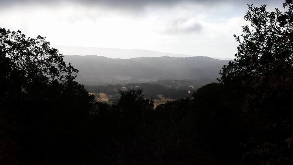
(The view from Monticello Road, back towards Wooden Valley, I got up with the sun, so there was still some morning mist.)
I got lucky, it was super hot the day I rode from Woodland to Wooden Valley Road, and a forest fire started right after I headed down Pleasants Valley Road, that I just missed cutting me off. Didn't get so lucky on my way back to the railhead in Sacramento when I left Clear Lake, several forest fires were converging, and although I was able to cycle back through the Capay Valley, it was through enough forest fire smoke, that I was covered in poison oak sores (I'm allergic) from sock line to shorts line and on my face and neck. Worse, I got it in my lungs, and I'd swear, they've never been quite the same.
I'm very tempted to take the Leesville route. It's looking like I've got an extra day to kill between Woodland and Clear Lake this time, so I'm tempted to tack up to Colusa, more or less following the Sacramento River, and stay at a BnB or something there or a motel in Williams. That way I can leave the camping gear behind this time. Even though it's only 65 miles from Colusa to the Clear Lake Riveria, I'm super SLOW in the mountains, even without the camping gear aboard, it'll be a long day, especially since I'll need to load up on water.
Thanks again!

Excellent write up BTW! Thanks for sharing!
.