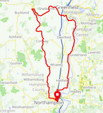
Did another ride north, again up North Farms Rd up through Whately, Weber Road, Conway etc but this staying on Shelburne Falls Rd to its destination. Crossed at Salmon Falls then RT 2 to Greenfield, finding my way past the rail yards to River Rd and down that into Hatfield and finally Elm Street west above the bend in the river to pick up RT 5 back to Hamp.
After Conway the climb on Shelburne Falls Rd immediately following where Bardswell Ferry Rd (and last week's ride) branches off was substantial, also a lot of grit on the pavement. Probably should have used the driveway of the shooting club for a rest, instead pressed on and quickly stalled out and had to walk 30 vertical feet to a driveway where I could re-mount (also triggering the first of the day's three cars stopping to ask if I was OK) But at least it was the only hill walk of the day, unlike last week's many!
While hilly this is mostly a rather nice ride up to Shelburne Falls though the last mile into the village has poor paving condition and somewhere in there was a descent that wouldn't be fun to ride back up. The Salmon Falls are kind of nifty, you can see where the river drilled into the rock in the years before the dam, and its easy to imagine salmon leaping upstream. The old trolley bridge that's been planted with overflowing flowers as a pedestrian path was closed for the season but could get a sense of it from the gate road bridge. Trolly Museum is closed for COVID, much off the town center seemed to be open, definitely shops and eateries with local character though didn't sample any.
RT 2 from Shelburne Falls towards Greenfield is pretty decent for the most part with a quite generous shoulder though definitely some climbs of rolling hills as the road ventures from one valley to another. The thing is that it ends with a CRAZY descent - so long I had to take breaks to give my brake hand a rest! At one spot there was a tower that claimed you could see both VT and NH; took my best shot from the shoulder. Would not want to be trying to climb that in the reverse direction, not just because of the hill but because the shoulder on the uphill side becomes a truck climbing lane. Also ends with a rotary at the I91 interchange. On an ordinary bike the descent would be a non-issue so it's a viable route eastbound though it would take a lot of determination to to it in the west direction. Navigation wanted to route my across one loop of the middle part on OId Greenfield road which might have been nice; pictures I saw showed less than wonderful pavement so I opted for the slightly longer way on RT 2's generous shoulder.
Working my east from Greenfield towards River Rd wasn't bad though the stretch by the East Deerfield rail yards has little to recommend it. Unlike the Turner's Falls (Monatague) side, the road on the west bank is pretty hilly until you get much of the way down towards the RT 116 crossing. But from a bit north of the 116 bridge down through Hatfield it was a nice flat fast ride on wide low traffic roads that are often laced with crack sealer but still pretty smooth regardless. Bad timing meant well more than the last 10 miles were done after dark with a headlamp, but fortunately the breeze dropped with the sun so the early dark wasn't very cold.

----------------
After three major trips north in a hair under three weeks, I'll try to summarize my feelings on the various routings
Amherst, Leveret, Turner's Falls: This is a charming route, good quiet roads, some scenery, only moderate climbing (unless one opts to go up to the Peace Pagoda). For me though it means the extra distance of the rail trail ride out to Amherst
Montague side of the river (east) is really nice in the north, pretty flat ride through farm meadows. Only Falls Rd dumps into RT 47 a mile and half north of the 116 bridge; RT 47 is tolerable at low traffic times but doesn't have much of a shoulder.
River Road on the Deerfield side of the river (west): quite a bit more hilly in the northern portion as the road follows hillsides more than the river. Not as scenic as hoped but not bad. Descends to the river just north of 116 and then is a nice flat ride on decent wide roads all the way down to Hatfiled where Elm street then continues west to meet RT 5.
Seems like a combination of the above two could be good: River Rd in the southern portion through Hatfield, across the 116 bridge (looks reasonable on streetview), mile and a half of RT 47 on the Sunderland side up to Falls Rd and then follow along the river up to Turner's Falls.
RT 5 itself - flat, tolerable shoulder, straight, flat and efficient - just not particularly interesting. The expansive crossing of I91 just south of Yankee Candle has some issues through: busy, weeds overflowing into the shoulder, and really broken up pavement and detritus in the shoulder on the bridge over 91 itself. Unfortunately a detour would go quite a bit out of the way on Long Plain Rd and Christian Ln.
North Fams Rd through Whately to Conway - nice ride though lots of climbing makes it probably not the best prelude for say, riding into Vermont next spring. Heading towards Bardswell's Ferry means a big drop and then climb back up; looks like Hawk Rd could save some of the climb on the northbound side if trying to make a shorter loop, but haven't tried that (D2DR routes over it though)