


mytracks discontinued
 02-01-16, 12:42 PM
#1

GATC
Thread Starter
 02-01-16, 03:18 PM
#2
Senior Member
Join Date: Jul 2008
Location: Minneapolis, MN
Posts: 6,432
Mentioned: 13 Post(s)
Tagged: 0 Thread(s)
Quoted: 539 Post(s)
Liked 44 Times
in
38 Posts
I just ran into this yesterday... :-(
Does Google Fit do the same mapping / tracking stuff? The last time I tried it it didn't seem to do the same thing, just gave you some vague stats. But I could have just missed it, or they could have updated it.
Does Google Fit do the same mapping / tracking stuff? The last time I tried it it didn't seem to do the same thing, just gave you some vague stats. But I could have just missed it, or they could have updated it.
02-01-16, 03:44 PM
#3
Senior Member
This is why I never use Google products unless I know they're winners.
Even then I'm been burned (Google Reader seemed like a sure thing for a while).
Even then I'm been burned (Google Reader seemed like a sure thing for a while).
02-01-16, 03:55 PM
#4
GATC
Thread Starter
6+ yrs of mytracks seemed like a decent run! But yes this is the 2nd rug they've pulled out from under me, the other was a to-do list thing.
02-02-16, 03:28 PM
#5

aka Tom Reingold

Join Date: Jan 2009
Location: New York, NY, and High Falls, NY, USA
Posts: 40,498
Bikes: 1962 Rudge Sports, 1971 Raleigh Super Course, 1971 Raleigh Pro Track, 1974 Raleigh International, 1975 Viscount Fixie, 1982 McLean, 1996 Lemond (Ti), 2002 Burley Zydeco tandem
Mentioned: 511 Post(s)
Tagged: 0 Thread(s)
Quoted: 7346 Post(s)
Liked 2,452 Times
in
1,430 Posts
Google Voice turned out to be annoying. Before that, you used to be able to search for people's phone numbers, and in particular, you could search ON a phone number. I understand why people didn't like that, but damn, it was useful.
__________________
Tom Reingold, tom@noglider.com
New York City and High Falls, NY
Blogs: The Experienced Cyclist; noglider's ride blog
�When man invented the bicycle he reached the peak of his attainments.� � Elizabeth West, US author
Please email me rather than PM'ing me. Thanks.
Tom Reingold, tom@noglider.com
New York City and High Falls, NY
Blogs: The Experienced Cyclist; noglider's ride blog
�When man invented the bicycle he reached the peak of his attainments.� � Elizabeth West, US author
Please email me rather than PM'ing me. Thanks.
02-05-16, 10:56 AM
#6
GATC
Thread Starter
not liking google fit as a sub for mytracks after 1 commute leg
02-05-16, 11:24 AM
#7
Senior Member
Join Date: Apr 2008
Location: St. Pete, Florida
Posts: 1,258
Mentioned: 1 Post(s)
Tagged: 0 Thread(s)
Quoted: 83 Post(s)
Likes: 0
Liked 1 Time
in
1 Post
Take a look at OruxMaps (https://play.google.com/store/apps/d...oruxmaps&hl=en). Nice feature set. Works without a data connection. Exports to KML, KMZ, and GPX. Live tracking through various servers (if you want it). Etc.
02-05-16, 07:10 PM
#8
The Rock Cycle

I have been using My Tracks for a while and I like it, sorry to see it go. I am trying Google Fit and I will look into Orux Maps.
__________________
Gunnar Sport
Specialized Ruby
Salsa Vaya Ti
Novara Randonee x2
Motobecane Fantom CXX
Jamis Dakar XCR
Gunnar Sport
Specialized Ruby
Salsa Vaya Ti
Novara Randonee x2
Motobecane Fantom CXX
Jamis Dakar XCR
02-06-16, 09:52 AM
#9
GATC
Thread Starter
Google Fit does record elevation and speed profiles (or its estimates of them) like mytracks, but does not separate moving average speed from total average speed, and also keeps recording time when you pause it which brings the total average way down (and makes the phone do more than it seems like it should). Also I can't figure out how to make it stop talking to me. I turned off sounds and notifications, it still keeps talking.
Osmand has been a mapping app I like for offline use (especially internationally where I don't want to pay for data) and it does record tracks but no summary info.
Orux Maps looks cool.
Osmand has been a mapping app I like for offline use (especially internationally where I don't want to pay for data) and it does record tracks but no summary info.
Orux Maps looks cool.
04-30-16, 08:40 AM
#10
GATC
Thread Starter
Last day of mytracks, argh. Still have not found a replacement I like. Will re-check strava and ridewithgps I guess.
04-30-16, 09:05 AM
#11
Senior Member
Sign up for https://tapiriik.com. Then you can sign up for all the free services - Garmin Connect, Strava, RideWithGPS, Endmondo, etc... Tapiriik will sync them all. If a service goes away, you're still covered.
J.
J.
04-30-16, 09:26 AM
#12
Senior Member

Join Date: Oct 2013
Location: D'uh... I am a Cutter
Posts: 6,139
Bikes: '17 Access Old Turnpike Gravel bike, '14 Trek 1.1, '13 Cannondale CAAD 10, '98 CAD 2, R300
Mentioned: 62 Post(s)
Tagged: 0 Thread(s)
Quoted: 1571 Post(s)
Likes: 0
Liked 12 Times
in
9 Posts
That sucks! But.... a great reminder that many (if not most) of these products will be temporary. They are expensive to use with monthly fees and yet are wildly popular..... or they have some vague embedded advertisement and upgrade options (profit) scheme.
I've been using Cyclemeter. The app was insanely cheap with only a one-time purchase price. Period. I regularly (monthly) copy the most important stats into a word doc, that I email (a version of) to my phone (and store on the cloud). So.... I guess I could switch stat apps easy enough if... when.. the time comes.
Thanks for the reminder! I think I might just print a paper copy of my digital stats.... just to stick in my cycling equipment locker.
04-30-16, 03:25 PM
#13
Thunder Whisperer

Join Date: Apr 2008
Location: NE OK
Posts: 8,843
Bikes: '06 Kona Smoke
Mentioned: 6 Post(s)
Tagged: 0 Thread(s)
Quoted: 275 Post(s)
Likes: 0
Liked 6 Times
in
2 Posts
Despite not being totally accurate (but then again, what tracking app is?), it was still my favorite. No ads, didn't try to sell branded accessories like HRMs (Runtastic, Sports-Tracker).
Never cared for Fit. It has been wildly inaccurate- classifying some of my walks as runs and thinks I'm riding a bike when I am actually in a car.
Currently using S Health for Android. Too early to tell if it is a keeper or not...
Never cared for Fit. It has been wildly inaccurate- classifying some of my walks as runs and thinks I'm riding a bike when I am actually in a car.
Currently using S Health for Android. Too early to tell if it is a keeper or not...
__________________
Community guidelines
Community guidelines
05-01-16, 07:03 AM
#14
Senior Member
Join Date: Dec 2015
Posts: 276
Mentioned: 0 Post(s)
Tagged: 0 Thread(s)
Quoted: 15 Post(s)
Likes: 0
Liked 0 Times
in
0 Posts
boo. Apparently there's an open source version from 2013, and there are ways you can keep the apk if you already have it installed. The odd thing is the report seems to claim it won't work anymore. So that's odd. I would think it uses a standard google map api and the rest is all local sensor stuff so how exactly does that stop working? There must be at least some aspect of the api that isn't pure google maps. It could be possible for someone to hack around in the open source version and work out how to circurmvent any possible disabling mechanism and/or implement a new mapping api, like a standard google map one, or reverse engineer the fit one. I wouldn't count on anyone doing it.
In best case, the reports are confused and it actually just keeps working?
In best case, the reports are confused and it actually just keeps working?
05-01-16, 10:10 AM
#15
Thunder Whisperer
Join Date: Apr 2008
Location: NE OK
Posts: 8,843
Bikes: '06 Kona Smoke
Mentioned: 6 Post(s)
Tagged: 0 Thread(s)
Quoted: 275 Post(s)
Likes: 0
Liked 6 Times
in
2 Posts
This is a bit strange. I attempted to look up My Tracks in the Play Store yesterday on my laptop (Win10-based) and my phone (Android 5.1.1) and I couldn't find the one by Google. Then I tried it on my Nexus 7 2012 (5.1.1) and it was there. I installed it, tried it, and it wouldn't get a GPS lock. Then I installed it on the phone and it appears to work- despite the warning up front that it won't (it got an accurate GPS lock).
I'll use it when I walk the dog in a bit and report back my findings.
I'll use it when I walk the dog in a bit and report back my findings.
__________________
Community guidelines
Community guidelines
05-01-16, 03:39 PM
#16
Thunder Whisperer
Join Date: Apr 2008
Location: NE OK
Posts: 8,843
Bikes: '06 Kona Smoke
Mentioned: 6 Post(s)
Tagged: 0 Thread(s)
Quoted: 275 Post(s)
Likes: 0
Liked 6 Times
in
2 Posts
Well, despite the "app no longer supported" when I installed it and an "unable to locate GPS" message, I have successfully recorded my walk- one for the outbound and another for the return.
So, yeah, I don't know what's going on with it...
So, yeah, I don't know what's going on with it...
__________________
Community guidelines
Community guidelines
05-01-16, 03:48 PM
#17
Thunder Whisperer
Join Date: Apr 2008
Location: NE OK
Posts: 8,843
Bikes: '06 Kona Smoke
Mentioned: 6 Post(s)
Tagged: 0 Thread(s)
Quoted: 275 Post(s)
Likes: 0
Liked 6 Times
in
2 Posts
I discovered that when I viewed a previous activity, the display was essentially split three ways. Part of a map on top, a colored banner in the middle (activity/file name), and then stats on the bottom. The banner acted as a shade- swipe down to expand the map, swipe up to expand the stats.
__________________
Community guidelines
Community guidelines
05-02-16, 06:06 AM
#18
Senior Member
Join Date: Dec 2015
Posts: 276
Mentioned: 0 Post(s)
Tagged: 0 Thread(s)
Quoted: 15 Post(s)
Likes: 0
Liked 0 Times
in
0 Posts
I reinstalled Fit yesterday and then accessed previous activities (from last year) and noticed that they have updated to include mapping- though I didn't see a dedicated map/view route option.
I discovered that when I viewed a previous activity, the display was essentially split three ways. Part of a map on top, a colored banner in the middle (activity/file name), and then stats on the bottom. The banner acted as a shade- swipe down to expand the map, swipe up to expand the stats.
I discovered that when I viewed a previous activity, the display was essentially split three ways. Part of a map on top, a colored banner in the middle (activity/file name), and then stats on the bottom. The banner acted as a shade- swipe down to expand the map, swipe up to expand the stats.
My version is way out of date. I turn updates off and don't generally do them unless I feel an urge, which often is never for things that are working fine. (I don't do this with computers, bad idea). Anyway, it works the same now as before. There's no GPS message, warning, nothing. It just works.
05-02-16, 11:15 AM
#19
GATC
Thread Starter
Well, mine is also working today, so far so good...
05-02-16, 01:45 PM
#20
don't try this at home.

Join Date: Jan 2006
Location: N. KY
Posts: 5,933
Mentioned: 10 Post(s)
Tagged: 0 Thread(s)
Quoted: 972 Post(s)
Liked 509 Times
in
349 Posts
I upload selected ride recordings to Strava or ridewithgps.
But I store all my rides on my PC using "My Tourbook". It's open source software that has ride statistics by ride, by month, and by year. I can tag rides into categories, and see the routes on the map window. I can see graphs of speed, cadence, heartrate, elevation,etc.
It's kind of the opposite of social media sites like Strava, just data and history.
It works very well, but there's a learning curve to get it set the way you like. All the displays are customizable. I have it set to keep the map tiles it downloads on my PC, so the next time, the map displays instantly. Download at mytourbook.sourceforge.net/mytourbook/
Some My Tourbook displays:
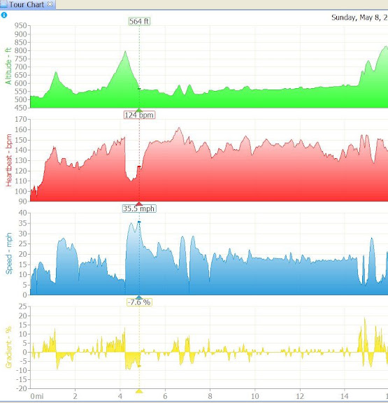
My standard display. Recent rides are listed at top left, with monthly and yearly totals. The highlighted ride shows the map, and the bottom has graphs of elevation (green), heartrate (red), speed (blue),

graphs zoomed in, and grade % (yellow)
The map zoomed way in. Each dot is a GPS recorded data point, color coded by speed. You can see the out-and-back tracks on opposite sides of the road.

Climbing up (blue) then zooming downhill on Stonehouse Road, Campbell County KY.

But I store all my rides on my PC using "My Tourbook". It's open source software that has ride statistics by ride, by month, and by year. I can tag rides into categories, and see the routes on the map window. I can see graphs of speed, cadence, heartrate, elevation,etc.
It's kind of the opposite of social media sites like Strava, just data and history.
It works very well, but there's a learning curve to get it set the way you like. All the displays are customizable. I have it set to keep the map tiles it downloads on my PC, so the next time, the map displays instantly. Download at mytourbook.sourceforge.net/mytourbook/
Some My Tourbook displays:
My standard display. Recent rides are listed at top left, with monthly and yearly totals. The highlighted ride shows the map, and the bottom has graphs of elevation (green), heartrate (red), speed (blue),
graphs zoomed in, and grade % (yellow)
The map zoomed way in. Each dot is a GPS recorded data point, color coded by speed. You can see the out-and-back tracks on opposite sides of the road.
Climbing up (blue) then zooming downhill on Stonehouse Road, Campbell County KY.
Last edited by rm -rf; 05-02-16 at 03:12 PM.
05-02-16, 02:36 PM
#21
GATC
Thread Starter
That is very cool thanks for showing it.
05-03-16, 12:32 AM
#22
Senior Member
Join Date: Jun 2009
Location: Silicon Valley, CA
Posts: 3,209
Mentioned: 2 Post(s)
Tagged: 0 Thread(s)
Quoted: 139 Post(s)
Liked 33 Times
in
20 Posts
One of the unique features that MyTracks had was showing live progress. This was a great feature when I was riding every street in Santa Clara. I want to do Sunnyvale as well, but really need an app that shows the track as it is being collected :-/
05-03-16, 12:43 AM
#23
cowboy, steel horse, etc

Join Date: Sep 2008
Location: The hot spot.
Posts: 44,790
Bikes: everywhere
Mentioned: 71 Post(s)
Tagged: 1 Thread(s)
Quoted: 12740 Post(s)
Liked 7,652 Times
in
4,058 Posts
Strava shows tracks while recording. You have to pay $6 to see your personal heat map, though.
05-03-16, 10:42 AM
#24
Senior Member
Join Date: Jul 2008
Location: Minneapolis, MN
Posts: 6,432
Mentioned: 13 Post(s)
Tagged: 0 Thread(s)
Quoted: 539 Post(s)
Liked 44 Times
in
38 Posts
I know RideWithGps shows you a map of where you are, have been, while collecting data. Auto-pause is great for biking, but I've turned it off so I can use it for Hikes/Walks and it's worked well for that as well.
Definitely shows you a live map of where you've been and where you are, as well as different kinds of maps available, some show you trails and routes that are not roads that I've found useful.
05-03-16, 10:59 AM
#25
cowboy, steel horse, etc
Join Date: Sep 2008
Location: The hot spot.
Posts: 44,790
Bikes: everywhere
Mentioned: 71 Post(s)
Tagged: 1 Thread(s)
Quoted: 12740 Post(s)
Liked 7,652 Times
in
4,058 Posts
I think my favorite GPS recording app might become GPS Essentials. A little more complicated than most bike-oriented apps. I'm not sure if it has an auto-pause feature yet.
The thing that really has me loving it is that it has a built-in camera control with compass headings displayed on the preview screen and that records your location and camera heading with the photo. This is really handy if you want to make cue sheets with pics of the turns, or if you'd like to place pics on a map later, for example.
You can also leave notes that get tagged with your location and heading.
I guess I should take a screenshot...

That's just a thumbnail of the pic. In the app you tap on the thumbnail for a higher resolution pic.
I haven't found a way to show elevation profiles within the app yet, but haven't really looked. Also, hours:mins:secs on the timestamps would be nice.
The thing that really has me loving it is that it has a built-in camera control with compass headings displayed on the preview screen and that records your location and camera heading with the photo. This is really handy if you want to make cue sheets with pics of the turns, or if you'd like to place pics on a map later, for example.
You can also leave notes that get tagged with your location and heading.
I guess I should take a screenshot...
That's just a thumbnail of the pic. In the app you tap on the thumbnail for a higher resolution pic.
I haven't found a way to show elevation profiles within the app yet, but haven't really looked. Also, hours:mins:secs on the timestamps would be nice.
Last edited by LesterOfPuppets; 05-03-16 at 11:12 AM.