


If I going to buy a Garmin: Edge 800 or 810?
 01-27-13, 04:46 PM
#1
Senior Member
Thread Starter

Join Date: Jul 2011
Location: Cape Cod, Ma.
Posts: 161
Bikes: 2008 Cannondale Synapse SL with Campy Record 10sp
Mentioned: 0 Post(s)
Tagged: 0 Thread(s)
Quoted: 0 Post(s)
Likes: 0
Liked 0 Times
in
0 Posts
If I going to buy a Garmin: Edge 800 or 810?
I am looking at ebay and see alot of Garmin Edge 800's for sale. I read up on the 810 but I can get a 800 for alot less money. Anyone have a 810 now? Also anyone with a 800 what do you think of it.
 01-28-13, 10:18 AM
#3
Senior Member
Join Date: Apr 2006
Location: San Jose, CA
Posts: 1,840
Bikes: Bianchi San Remo - set up as a utility bike, Peter Mooney Road bike, Peter Mooney commute bike,Dahon Folder,Schwinn Paramount Tandem
Mentioned: 0 Post(s)
Tagged: 0 Thread(s)
Quoted: 2 Post(s)
Likes: 0
Liked 0 Times
in
0 Posts
I have the 800 and am pretty happy with it. The biggest weakness, in my opinion, is poor screen contrast. In some lighting situations it is hard to read. I also had an issue in that I downloaded the NA maps, and they worked great for a while, but then the file got corrupted, and Garmin's suggested solution was to buy another set of maps. Customer service could be better.
I have looked at the 810, and the new features are not things that have a lot of value to me, so I am not looking to upgrade.
I have looked at the 810, and the new features are not things that have a lot of value to me, so I am not looking to upgrade.
01-28-13, 11:15 AM
#4
Senior Member

Join Date: Dec 2010
Posts: 8,951
Mentioned: 0 Post(s)
Tagged: 0 Thread(s)
Quoted: 14 Post(s)
Likes: 0
Liked 13 Times
in
12 Posts
The only features on the 810 over the 800 that would have value to me is having 10 instead of only 3 bike profiles, and the ability to save different screen setups for different types of rides/activities. Its biggest new feature, bluetooth connectivity through a smart phone, has virtually no value to me. The screen contrast is just as bad as the 800.
01-28-13, 04:26 PM
#5
Senior Member
Join Date: Nov 2008
Location: Hollister, CA
Posts: 3,957
Bikes: Volagi, daVinci Joint Venture
Mentioned: 0 Post(s)
Tagged: 0 Thread(s)
Quoted: 0 Post(s)
Likes: 0
Liked 3 Times
in
2 Posts
Regarding maps - the 800 (and I assume the 810) will work just fine with Open Source Maps. I have both on my 800; bought the Garmin maps while trying to get turn-by-turn to work. "Turns" out that my problem had nothing to do with the maps and I was able to get things going. Garmin documentation leaves a lot to be desired, but I'd be shocked if anything has changed since release of the 800.
I definitely like the turn-by-turn directions. Would have prevented a 35 mile excursion in the Marin 100K!
I definitely like the turn-by-turn directions. Would have prevented a 35 mile excursion in the Marin 100K!
01-28-13, 06:31 PM
#6
Senior Member
Thread Starter
Join Date: Jul 2011
Location: Cape Cod, Ma.
Posts: 161
Bikes: 2008 Cannondale Synapse SL with Campy Record 10sp
Mentioned: 0 Post(s)
Tagged: 0 Thread(s)
Quoted: 0 Post(s)
Likes: 0
Liked 0 Times
in
0 Posts
Looks like I can get a 800 bundle set for the price of a 810. Well I'll try and bid on one and see how I do!
01-29-13, 08:05 AM
#7
Senior Member
Join Date: Oct 2011
Location: Denver, CO
Posts: 109
Bikes: Airborne Manhattan Project, Quinta Roo Kilo, Schwinn Passage
Mentioned: 0 Post(s)
Tagged: 0 Thread(s)
Quoted: 2 Post(s)
Likes: 0
Liked 0 Times
in
0 Posts
I have a Garmin 800, and in retrospect, I think I would have been just as happy with the 500. I do like the new features of the 510/810 though and now wish that I had those. Oh, well.
01-29-13, 08:25 AM
#8
Senior Member
Join Date: Dec 2010
Posts: 8,951
Mentioned: 0 Post(s)
Tagged: 0 Thread(s)
Quoted: 14 Post(s)
Likes: 0
Liked 13 Times
in
12 Posts
Many don't realize that a you can download a route to a 500 and it will depict a breadcrumb track on it's screen that you can follow. It doesn't have maps so won't show any roads and doesn't give turn guidance, but you can easily see if you've wandered off the track.
01-31-13, 08:54 PM
#9
Senior Member
Join Date: Apr 2006
Location: Escondido, CA
Posts: 2,240
Mentioned: 0 Post(s)
Tagged: 0 Thread(s)
Quoted: 1 Post(s)
Likes: 0
Liked 0 Times
in
0 Posts
Reading about 510/810 now. Sounds interesting on paper. However, I already have live tracking through a free Android app, I'm not sure what's the value of being able to display the weather forecast on the Edge, and wireless activity upload is not a huge plus if you have to plug the unit into USB to recharge it anyway.
I'll be thinking about it more, but, at current eBay prices, I'd probably take 800 over 510.
I'll be thinking about it more, but, at current eBay prices, I'd probably take 800 over 510.
02-01-13, 04:43 AM
#10
Member
Join Date: Dec 2010
Location: Phoenix, AZ
Posts: 29
Bikes: Trek 1.2 2011
Mentioned: 0 Post(s)
Tagged: 0 Thread(s)
Quoted: 0 Post(s)
Likes: 0
Liked 0 Times
in
0 Posts
I'm just wondering why the 510 is being released so late compared to the 810. I mean, the 810 is nice, but I think it, as well as the 800, are a bit big IMO. I think the 510 is perfect in size and it has the touch screen as well as the cleaner interface. Anyways, I would pick up an 800 from a place with a liberal return policy and just get it. That way if you find yourself not utilizing it to it's fullest or don't need the mapping you can exchange for the 510.
02-01-13, 11:33 AM
#11
Because I thought I could

Join Date: Dec 2004
Location: Wash DC Metro
Posts: 969
Bikes: November, Trek OCLV, Bianchi Castro Valley commuter
Mentioned: 0 Post(s)
Tagged: 0 Thread(s)
Quoted: 0 Post(s)
Likes: 0
Liked 0 Times
in
0 Posts
03-18-13, 04:58 AM
#12
Member
Join Date: Jan 2013
Location: MD
Posts: 8
Bikes: 2011 Specialized Hardrock, 2008 Jamis Xenith SL
Mentioned: 0 Post(s)
Tagged: 0 Thread(s)
Quoted: 0 Post(s)
Likes: 0
Liked 0 Times
in
0 Posts
sorry for bringing up a dead thread but I figure I ask the same question. any changes since Feb?
thanks for your help
thanks for your help
03-18-13, 06:27 AM
#13
Senior Member
Join Date: Dec 2010
Posts: 8,951
Mentioned: 0 Post(s)
Tagged: 0 Thread(s)
Quoted: 14 Post(s)
Likes: 0
Liked 13 Times
in
12 Posts
Check out the respective forums here: https://forums.garmin.com/forumdisplay.php?20-Cycling
03-18-13, 09:29 AM
#14
Senior Member

Join Date: Aug 2012
Location: Stamford, CT
Posts: 57
Bikes: Canondale CAAD10
Mentioned: 0 Post(s)
Tagged: 0 Thread(s)
Quoted: 0 Post(s)
Likes: 0
Liked 0 Times
in
0 Posts
From a mapping perspective only (quality of maps), is there a difference between the maps in the 800 and the maps in the 810?
03-18-13, 12:57 PM
#15
Senior Member
Join Date: Dec 2010
Posts: 8,951
Mentioned: 0 Post(s)
Tagged: 0 Thread(s)
Quoted: 14 Post(s)
Likes: 0
Liked 13 Times
in
12 Posts
No difference. Neither unit comes with usable maps in their base form. Maps are extra or available on the web. The units have the same display and the maps that work on either are the same. Garmin's CityNavigator maps and various open source maps.
03-18-13, 06:10 PM
#16
shut up and ride
Join Date: Nov 2005
Location: noho
Posts: 1,947
Bikes: supersix hi-mod,burley duet tandem,woodrup track,cannondale cross,specialized road
Mentioned: 0 Post(s)
Tagged: 0 Thread(s)
Quoted: 2 Post(s)
Likes: 0
Liked 0 Times
in
0 Posts
i've heard the 810 is really buggy, my local shop has had one returned by a customer and sent their stock back of 810s back.
03-19-13, 05:37 AM
#17
Senior Member
Join Date: Aug 2012
Location: Stamford, CT
Posts: 57
Bikes: Canondale CAAD10
Mentioned: 0 Post(s)
Tagged: 0 Thread(s)
Quoted: 0 Post(s)
Likes: 0
Liked 0 Times
in
0 Posts
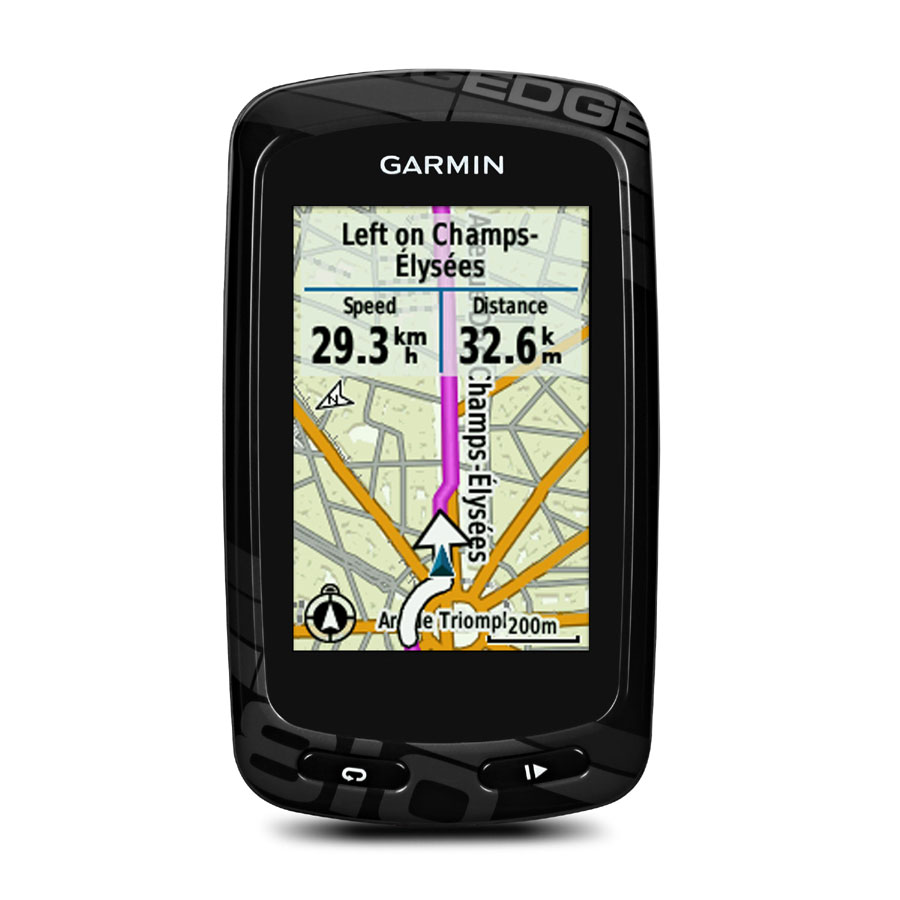
I'm a bit confused. I thought the 810 comes with a micro-SD loaded with North America? Is that what you're referring to by 'City Navigator maps'? When you say that neither one comes with usable maps, I'm a bit puzzled. All pictures I've seen of the 810 (such as the one below), clearly show a map.... Or by 'no usable map', you mean I can't scroll the display to view nearby roads? - only my route for turn by turn navigation?
 03-19-13, 12:19 PM
#18
Senior Member
Join Date: Dec 2010
Posts: 8,951
Mentioned: 0 Post(s)
Tagged: 0 Thread(s)
Quoted: 14 Post(s)
Likes: 0
Liked 13 Times
in
12 Posts
The base unit does not have usable maps. You need to by a package that includes a map, buy the maps separately, or use OS maps. Garmin's maps are called CityNavigator and are available on CD, microSD card, or via download. The go for ~$100.
Info is on the Garmin website: https://buy.garmin.com/shop/shop.do?cID=160&pID=112912
Edge 810 $500
Edge 810 Performance and Navigation Bundle $700
Info is on the Garmin website: https://buy.garmin.com/shop/shop.do?cID=160&pID=112912
Edge 810 $500
- Edge 810
- Bike mount
- USB cable
- AC charger
- Manual
Edge 810 Performance and Navigation Bundle $700
- Edge 810
- Mounts (standard and out-front)
- Premium heart rate monitor
- Speed/cadence sensor
- Data card preloaded with City Navigator� for US, Canada and Puerto Rico street maps (maps on a preloaded data card cannot be copied or viewed on a computer)
- USB cable
- AC charger
- Manual
Last edited by Looigi; 03-19-13 at 12:23 PM.
03-19-13, 02:11 PM
#19
Senior Member
Join Date: May 2012
Location: Westchester County, NY
Posts: 1,299
Bikes: Giant TCR SL3 and Trek 1.5
Mentioned: 1 Post(s)
Tagged: 0 Thread(s)
Quoted: 12 Post(s)
Likes: 0
Liked 2 Times
in
2 Posts
I wouldn't say that at all. In fact, if anything, I'd say the 810 has capabilities that, while some may view as "neat," others will say "Why would i pay for that?" I don't really have a compelling desire for people to be able to track me in real time, even friends. That's basically the big enhancement in the 800 versus the 810.
03-20-13, 05:57 AM
#20
Senior Member
Join Date: Aug 2012
Location: Stamford, CT
Posts: 57
Bikes: Canondale CAAD10
Mentioned: 0 Post(s)
Tagged: 0 Thread(s)
Quoted: 0 Post(s)
Likes: 0
Liked 0 Times
in
0 Posts
I wouldn't say that at all. In fact, if anything, I'd say the 810 has capabilities that, while some may view as "neat," others will say "Why would i pay for that?" I don't really have a compelling desire for people to be able to track me in real time, even friends. That's basically the big enhancement in the 800 versus the 810.
03-20-13, 07:36 AM
#21
Senior Member
Join Date: Dec 2010
Posts: 8,951
Mentioned: 0 Post(s)
Tagged: 0 Thread(s)
Quoted: 14 Post(s)
Likes: 0
Liked 13 Times
in
12 Posts
You can't look at the data without having the site/program open anyway, so if it's open in the first place, connecting the USB and uploading the data might take all of 30 seconds.
Last edited by Looigi; 03-20-13 at 07:40 AM.
03-20-13, 04:18 PM
#22
Senior Member
Join Date: May 2012
Location: Westchester County, NY
Posts: 1,299
Bikes: Giant TCR SL3 and Trek 1.5
Mentioned: 1 Post(s)
Tagged: 0 Thread(s)
Quoted: 12 Post(s)
Likes: 0
Liked 2 Times
in
2 Posts
Sorry, but I've got to laugh. Just for the heck of it, I just uploaded a ride to my PC from my creaky old 705 starting with my browser running. Working casually, I found and clicked on the GC link in my favorites, connected the USB to the 705, waited for it to connect to the PC, clicked Upload, waited for it to upload, then opened it to view it. 49 seconds. That's a "major time/hassle"?
You can't look at the data without having the site/program open anyway, so if it's open in the first place, connecting the USB and uploading the data might take all of 30 seconds.
You can't look at the data without having the site/program open anyway, so if it's open in the first place, connecting the USB and uploading the data might take all of 30 seconds.
03-21-13, 07:02 AM
#23
Senior Member
Join Date: Dec 2010
Posts: 8,951
Mentioned: 0 Post(s)
Tagged: 0 Thread(s)
Quoted: 14 Post(s)
Likes: 0
Liked 13 Times
in
12 Posts
Certainly there won't be any firmware updates, but they are still "repairing" them. If you send one in for repair, they replace it with a refurbished unit with new battery and case for $110. I plan on doing that myself when the battery or buttons start on mine showing signs of crapping out. I'd much rather do that then get a 800 or 810. Aftermarket replacement batteries are available and easy enough to install, but once the rubber buttons start to go, you're SOL.
03-21-13, 10:28 AM
#24
Just Keep Pedaling

Join Date: Mar 2012
Location: Lakewood, CA
Posts: 3,355
Bikes: 99 Schwinn Mesa GS MTB, 15 Trek Domane 5.9 Dura-Ace, 17 Trek Emonda SL6 Pro & 18 Bianchi Vigorelli
Mentioned: 30 Post(s)
Tagged: 0 Thread(s)
Quoted: 251 Post(s)
Likes: 0
Liked 67 Times
in
34 Posts
Note re: turn by turn directions and the 500.
it can do turn directions using the tcx file downloaded from sites such as ridewithgps.com
I've been using this on my La Bella Preme training rides with team as I am leading the rides and am not 100% familiar with area we are riding in. Someone else designs route. I save route to my ridewithgps profile. Download the tcx file to my computer then transfer file to Garmin 500 using directions provided. It works pretty well.
03-21-13, 02:15 PM
#25
Senior Member
Join Date: Dec 2010
Posts: 8,951
Mentioned: 0 Post(s)
Tagged: 0 Thread(s)
Quoted: 14 Post(s)
Likes: 0
Liked 13 Times
in
12 Posts
Yes. Those cues are embedded in the TCX file by the software/site that created it. It doesn't depend on or require maps on the device. They are text messages that show up on the display and you can get the on the 705 by putting the tcx file in the courses directory and following a course rather than navigating a saved ride, which is what you do with gpx files. When navigating gpx (or FIT in the 800/801 case) the 705/800/810 will show a zoomed in diagram of the upcoming turn, much like an car GPS. Kinda nice, but not essential. And, of course these units will show all the roads, whereas the 500 and 510 will only show a breadcrumb trail on the screen with no roads or landmarks depicted.