


GPS-only: device for navigation
 05-28-13, 10:46 PM
#1
Senior Member
Thread Starter
Join Date: Feb 2011
Posts: 99
Mentioned: 0 Post(s)
Tagged: 0 Thread(s)
Quoted: 0 Post(s)
Likes: 0
Liked 1 Time
in
1 Post
GPS-only: device for navigation
I've been looking at GPS-based navigation devices for a while. What I want is a GPS-based device where I can load detailed maps that would have all highways, roads, and streets in a given area (e.g., south eastern US). I don't want a bike computer with speed, cadence, distance, etc., because I already have that. I only want the navigation/orientation capability (currently I'm using my iPhone and Google maps).
What I'm finding is a number of bike computers that also have GPS navigation, for instance, the Garmin Edge 800 and the new 810. But, like I said, that device has much more than I need (speed, cadence, HRM, training routines, etc.).
I found other devices like the Garmin Nuvi, which seems to have a good size touchscreen, or the (seemingly) bulkier Garmin Dakota. There are also a couple of devices under the generic name of Waterproof GPS (https://www.aliexpress.com/item/Hot-S...676536382.html) and Bike Kit Car GPS Navigator (https://www.ebay.com/itm/Portable-Tou...vip=true&rt=nc).
Any recommendations for a GPS navigation device that has a large screen (at least 4"), has the option of adding detailed maps (providing the equivalent of Google Maps), can be mounted on a bike, and does not include unnecessary (for me) functions such as speed, distance, cadence, HRM, training, intervals, etc?
Thanks in advance.
 05-29-13, 12:09 AM
#2
SuperGimp

I think you will find that there's not much call for GPS only... why would you want two devices on your bars? And 4 inch screen? Yikes!
Btw, the Garmin Edge 800 can be found for just over $300 right now and there's a $100 mail in rebate from Garmin. You can certainly ignore all the bike computer functions.
Btw, the Garmin Edge 800 can be found for just over $300 right now and there's a $100 mail in rebate from Garmin. You can certainly ignore all the bike computer functions.
05-29-13, 06:00 AM
#3
Senior Member
Thread Starter
Join Date: Feb 2011
Posts: 99
Mentioned: 0 Post(s)
Tagged: 0 Thread(s)
Quoted: 0 Post(s)
Likes: 0
Liked 1 Time
in
1 Post
I think you will find that there's not much call for GPS only... why would you want two devices on your bars? And 4 inch screen? Yikes!
Btw, the Garmin Edge 800 can be found for just over $300 right now and there's a $100 mail in rebate from Garmin. You can certainly ignore all the bike computer functions.
Btw, the Garmin Edge 800 can be found for just over $300 right now and there's a $100 mail in rebate from Garmin. You can certainly ignore all the bike computer functions.
I was thinking that a GPS that can also be used for trekking, for a motorcycle, and even for your car, would be a better choice in my situation.
Regarding the screen size, I prefer large font and a large screen. For instance, the Garming 800 has a 2.6" screen, which is barely enough for me. On a couple of trips I took an iPad and used Google Maps with it, and that was extremely effective screen size-wise (not so much weight-wise).
05-29-13, 06:37 AM
#4
Senior Member
Join Date: May 2013
Location: Lindenhurst, Long Island, NY
Posts: 69
Bikes: '13 Specialized Roubaix
Mentioned: 0 Post(s)
Tagged: 0 Thread(s)
Quoted: 0 Post(s)
Likes: 0
Liked 0 Times
in
0 Posts
I have a bar extender under the handlebars, so there is plenty of space and my handlebars would remain free. There are several reasons for two devices: a backup system, different mount locations, a GPS with voice directions that can even go into your pocker with a BlueTooth earbug, and also the fact that if I already have a good bicycle computer, why would I pay another $300 to have the same functions plus GPS navigation.
I was thinking that a GPS that can also be used for trekking, for a motorcycle, and even for your car, would be a better choice in my situation.
Regarding the screen size, I prefer large font and a large screen. For instance, the Garming 800 has a 2.6" screen, which is barely enough for me. On a couple of trips I took an iPad and used Google Maps with it, and that was extremely effective screen size-wise (not so much weight-wise).
Have you considered selling off the current computer to fund the GPS based unit? Just a thought. I've also been kicking around the idea of a second device, only so I can remove the GPS unit when I don't need it and I still have my $30 basic computer for all the core info I like to see. No need to have a GPS commuting.
So, I have to ask, do you have a picture of your iPad mounted to your bike. I MUST see this.
05-29-13, 07:14 AM
#5
Senior Member
Join Date: Sep 2007
Location: Far beyond the pale horizon.
Posts: 14,278
Mentioned: 31 Post(s)
Tagged: 0 Thread(s)
Quoted: 4260 Post(s)
Liked 1,362 Times
in
944 Posts
I've been looking at GPS-based navigation devices for a while. What I want is a GPS-based device where I can load detailed maps that would have all highways, roads, and streets in a given area (e.g., south eastern US). I don't want a bike computer with speed, cadence, distance, etc., because I already have that. I only want the navigation/orientation capability (currently I'm using my iPhone and Google maps).
What I'm finding is a number of bike computers that also have GPS navigation, for instance, the Garmin Edge 800 and the new 810. But, like I said, that device has much more than I need (speed, cadence, HRM, training routines, etc.).
I found other devices like the Garmin Nuvi, which seems to have a good size touchscreen, or the (seemingly) bulkier Garmin Dakota. There are also a couple of devices under the generic name of Waterproof GPS (https://www.aliexpress.com/item/Hot-S...676536382.html) and Bike Kit Car GPS Navigator (https://www.ebay.com/itm/Portable-Tou...vip=true&rt=nc).
Any recommendations for a GPS navigation device that has a large screen (at least 4"), has the option of adding detailed maps (providing the equivalent of Google Maps), can be mounted on a bike, and does not include unnecessary (for me) functions such as speed, distance, cadence, HRM, training, intervals, etc?
Thanks in advance.
What I'm finding is a number of bike computers that also have GPS navigation, for instance, the Garmin Edge 800 and the new 810. But, like I said, that device has much more than I need (speed, cadence, HRM, training routines, etc.).
I found other devices like the Garmin Nuvi, which seems to have a good size touchscreen, or the (seemingly) bulkier Garmin Dakota. There are also a couple of devices under the generic name of Waterproof GPS (https://www.aliexpress.com/item/Hot-S...676536382.html) and Bike Kit Car GPS Navigator (https://www.ebay.com/itm/Portable-Tou...vip=true&rt=nc).
Any recommendations for a GPS navigation device that has a large screen (at least 4"), has the option of adding detailed maps (providing the equivalent of Google Maps), can be mounted on a bike, and does not include unnecessary (for me) functions such as speed, distance, cadence, HRM, training, intervals, etc?
Thanks in advance.
Some one I ride with uses a motorcycle GPS that uses AA batteries (he swaps the batteries in the middle of the ride).
Note that routing might be an issue: the car-focused units might not provide routes that you'd want to bicycle on.
The random Chinese units certainly are cheap but you won't get much information about how well they work (you won't be able to get any service if you have problems with one) and you have no idea how long the battery lasts.
I suspect that many of the car/motorcycle units really don't have enough battery capacity to last for a long bicycle ride (you'd have to either be able to swap batteries or use an external pack). Given that, I don't think that would work better on a bike than a phone would.
Last edited by njkayaker; 05-29-13 at 07:26 AM.
05-29-13, 07:23 AM
#6
Senior Member

Join Date: Feb 2013
Location: Leesburg
Posts: 106
Bikes: Trek
Mentioned: 0 Post(s)
Tagged: 0 Thread(s)
Quoted: 0 Post(s)
Likes: 0
Liked 0 Times
in
0 Posts
I have the Dakota and really like it for my rides. I used it prior for our hikes and when I got in to biking it works great. If you use the turn by turn mode it should work for you. There are several maps available that you want, either from places like garmin or there are some free sites. I also have a newer nuvi(3490) and its about the size of an iphone 5. The dakota is ANT capable if you decide you need that. I would add that I think the nuvi is bulkier than the Dakota. The edge is a great product but the dakota is very versitle and bike friendly.
05-29-13, 09:30 PM
#7
Senior Member
Join Date: Jun 2007
Location: North West South Carolina
Posts: 505
Mentioned: 0 Post(s)
Tagged: 0 Thread(s)
Quoted: 3 Post(s)
Likes: 0
Liked 0 Times
in
0 Posts
I have the Dakota and really like it for my rides. I used it prior for our hikes and when I got in to biking it works great. If you use the turn by turn mode it should work for you. There are several maps available that you want, either from places like garmin or there are some free sites. I also have a newer nuvi(3490) and its about the size of an iphone 5. The dakota is ANT capable if you decide you need that. I would add that I think the nuvi is bulkier than the Dakota. The edge is a great product but the dakota is very versitle and bike friendly.
05-30-13, 04:06 AM
#8
Senior Member
Thread Starter
Join Date: Feb 2011
Posts: 99
Mentioned: 0 Post(s)
Tagged: 0 Thread(s)
Quoted: 0 Post(s)
Likes: 0
Liked 1 Time
in
1 Post
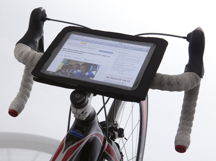
But if you want a picture, someone else set up their iPad on the handlebars the same way I would have done:
 05-30-13, 04:10 AM
#9
Senior Member
Thread Starter
Join Date: Feb 2011
Posts: 99
Mentioned: 0 Post(s)
Tagged: 0 Thread(s)
Quoted: 0 Post(s)
Likes: 0
Liked 1 Time
in
1 Post
That's what I've been doing, using my iPhone and MapMyRide. Still with a phone you need reliable cell service to connect to either Google Maps or MapMyRide, so I was looking for the next level up, something that would work independently (no data plans, no dependency on cell towers, etc.).
05-30-13, 04:23 AM
#10
Senior Member
Thread Starter
Join Date: Feb 2011
Posts: 99
Mentioned: 0 Post(s)
Tagged: 0 Thread(s)
Quoted: 0 Post(s)
Likes: 0
Liked 1 Time
in
1 Post
I have the Dakota and really like it for my rides. I used it prior for our hikes and when I got in to biking it works great. If you use the turn by turn mode it should work for you. There are several maps available that you want, either from places like garmin or there are some free sites. I also have a newer nuvi(3490) and its about the size of an iphone 5. The dakota is ANT capable if you decide you need that. I would add that I think the nuvi is bulkier than the Dakota. The edge is a great product but the dakota is very versitle and bike friendly.
In terms of price, your model (Nuvi 3490LMT) is around $250, while a Nuvi 2455LMT is around $140. I just browsed the specs and I did not notice any critical differences between them (e.g., SD card slot, screen size, etc.), except extra features, and weight/size.
05-30-13, 05:33 AM
#11
Senior Member
Join Date: Sep 2007
Location: Far beyond the pale horizon.
Posts: 14,278
Mentioned: 31 Post(s)
Tagged: 0 Thread(s)
Quoted: 4260 Post(s)
Liked 1,362 Times
in
944 Posts
That's what I've been doing, using my iPhone and MapMyRide. Still with a phone you need reliable cell service to connect to either Google Maps or MapMyRide, so I was looking for the next level up, something that would work independently (no data plans, no dependency on cell towers, etc.).
For the iPhone:
Motion X GPS lets you download maps easily and tracks (but doesn't provide turn-by-turn).
Motion X Drive lets you download maps (but not easily) and provides voice turn-by-turn for an extra monthly fee (I'm not sure if this is worth it). It looks like "Drive" will cache the maps for a computed route (which doesn't seem that useful for your purpose).
Last edited by njkayaker; 05-30-13 at 05:40 AM.
05-30-13, 05:34 AM
#12
The Recumbent Quant

That's what I've been doing, using my iPhone and MapMyRide. Still with a phone you need reliable cell service to connect to either Google Maps or MapMyRide, so I was looking for the next level up, something that would work independently (no data plans, no dependency on cell towers, etc.).
05-30-13, 05:39 AM
#13
Senior Member
Join Date: Sep 2007
Location: Far beyond the pale horizon.
Posts: 14,278
Mentioned: 31 Post(s)
Tagged: 0 Thread(s)
Quoted: 4260 Post(s)
Liked 1,362 Times
in
944 Posts
Google maps lets you cache the maps (on Android, at least) so you don't need data coverage (and I know there are other programs that do the same for both platforms). Particularly if you are in a spot with bad coverage, turning off the 3G/phone can save a lot of battery life.
05-30-13, 07:43 AM
#14
Senior Member
Join Date: Feb 2013
Location: Leesburg
Posts: 106
Bikes: Trek
Mentioned: 0 Post(s)
Tagged: 0 Thread(s)
Quoted: 0 Post(s)
Likes: 0
Liked 0 Times
in
0 Posts
https://www8.garmin.com/manuals/Dakot...nersManual.pdf
The battery life in the nuvi is shorter but if your in the car that doesnt factor in. Battery life in the gps can be managed, like haveing the screen power off sooner, less back lite etc. I havent need an extra set of batteries but a couple of extra AA could fit in your pocket or pouch. I would say the regualar AA's last about 6hrs of continous use?
@ Tony, you can find more info in the garmin instruction mannual link above, sorry I can't be more specfic because I dont use it in the car, but I got that from instructions and device. See page 23.
05-31-13, 03:56 AM
#15
Junior Member
Join Date: Jun 2009
Location: Columbus, OH
Posts: 23
Mentioned: 0 Post(s)
Tagged: 0 Thread(s)
Quoted: 0 Post(s)
Likes: 0
Liked 0 Times
in
0 Posts
The Dakota can also do cadence, speed, HRM, etc so if it is a deal breaker for you to have any bike computer functions the Dakota is out for you.
05-31-13, 10:35 AM
#16
Senior Member

Join Date: Dec 2009
Location: Erie, PA
Posts: 1,771
Bikes: Bacchetta Giro 20, Trek 7000, old Huffy MTB, and a few others
Mentioned: 0 Post(s)
Tagged: 0 Thread(s)
Quoted: 21 Post(s)
Likes: 0
Liked 0 Times
in
0 Posts
Google maps lets you cache the maps (on Android, at least) so you don't need data coverage (and I know there are other programs that do the same for both platforms). Particularly if you are in a spot with bad coverage, turning off the 3G/phone can save a lot of battery life.
So I guess it depends on how far you're going or how frequently you want to re-cache your data.
05-31-13, 11:17 AM
#17
The Recumbent Quant
At least on my phone the "Make available Offline" option only allows for a relatively small area to be cached. I'm not sure of the exact cross section.. maybe 50 - 60 miles left to right / top to bottom. I got up to around 100+ miles and it told me it was too large.
So I guess it depends on how far you're going or how frequently you want to re-cache your data.
So I guess it depends on how far you're going or how frequently you want to re-cache your data.
05-31-13, 02:00 PM
#18
Senior Member
Join Date: Dec 2009
Location: Erie, PA
Posts: 1,771
Bikes: Bacchetta Giro 20, Trek 7000, old Huffy MTB, and a few others
Mentioned: 0 Post(s)
Tagged: 0 Thread(s)
Quoted: 21 Post(s)
Likes: 0
Liked 0 Times
in
0 Posts
05-31-13, 02:05 PM
#19
The Recumbent Quant
 06-03-13, 09:58 AM
#20
Senior Member
Join Date: May 2013
Location: Lindenhurst, Long Island, NY
Posts: 69
Bikes: '13 Specialized Roubaix
Mentioned: 0 Post(s)
Tagged: 0 Thread(s)
Quoted: 0 Post(s)
Likes: 0
Liked 0 Times
in
0 Posts
Sorry to disappoint you, I carried the iPad in my pannier. I only took it out when I couldn't find a turn or a street, or when I wanted to know how far I was from the next turn. Google Maps gave me my exact position on a satellite map, much better than any paper map.
But if you want a picture, someone else set up their iPad on the handlebars the same way I would have done:

But if you want a picture, someone else set up their iPad on the handlebars the same way I would have done:
I think you have the better solution to use it as a check. Thanks for the pic!


Thread
Thread Starter
Forum
Replies
Last Post
Shponglefan
Electronics, Lighting, & Gadgets
19
07-12-14 05:22 PM
AngryScientist
Road Cycling
15
12-23-09 02:44 PM
