


Garmin 500 elevation question
 09-24-12, 07:56 AM
#1
Starting over
Thread Starter

Join Date: Jun 2005
Location: Indianapolis
Posts: 4,077
Bikes: 1990 Trek 1500; 2006 Gary Fisher Marlin; 2011 Cannondale Synapse Alloy 105; 2012 Catrike Trail
Mentioned: 0 Post(s)
Tagged: 0 Thread(s)
Quoted: 10 Post(s)
Likes: 0
Liked 3 Times
in
3 Posts
Garmin 500 elevation question
I have a Garmin 500 that I've been using since early this season. Lately, like on the last couple of rides, the elevation data it compiles has shown an odd little anomaly that I wonder if anyone else has experienced. On both of these rides, I stopped at local cafes, turned off the timer (but let the unit power itself down) and grabbed a quick bite to eat, staying there for maybe 20 minutes or so. WHen done, I get back on the bike, power up the unit, restart the timer and continue on my way. Once home, I upload the data to the Garmin site, and to Strava, and both shown an identical jump in elevation that bears no resemblance to the actual terrain - like a 300' cliff face on the graph. On close inspection, I find these have happened at the point in my ride where I stop to eat and the computer is inactive.
Anyone else have this happening? Any ideas? I've had this happen with the temperature data because the unit has been sitting in the sun, but never with elevation. In neither case was there a change in weather while I was stopped, so I don't think any atmospheric pressure differences are accounting for it. I never really relied too much on the elevation data to begin with, but with Hilly Hundred coming up in a few weeks, I'd like to think it would give me some more realistic data.
Anyone else have this happening? Any ideas? I've had this happen with the temperature data because the unit has been sitting in the sun, but never with elevation. In neither case was there a change in weather while I was stopped, so I don't think any atmospheric pressure differences are accounting for it. I never really relied too much on the elevation data to begin with, but with Hilly Hundred coming up in a few weeks, I'd like to think it would give me some more realistic data.
 09-24-12, 08:04 AM
#2
Starting over
Thread Starter
Join Date: Jun 2005
Location: Indianapolis
Posts: 4,077
Bikes: 1990 Trek 1500; 2006 Gary Fisher Marlin; 2011 Cannondale Synapse Alloy 105; 2012 Catrike Trail
Mentioned: 0 Post(s)
Tagged: 0 Thread(s)
Quoted: 10 Post(s)
Likes: 0
Liked 3 Times
in
3 Posts
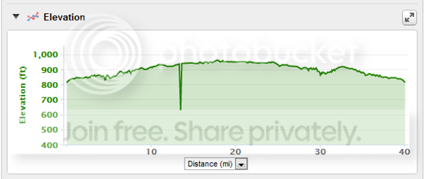
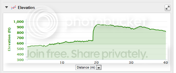
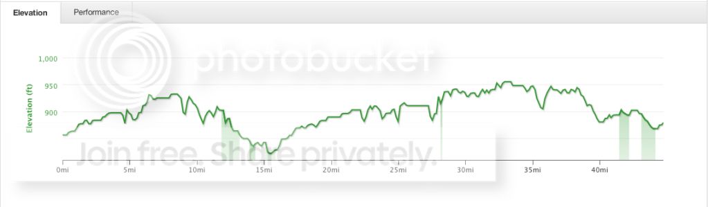
FYI, here are the elevation graphs for yesterday's ride:
Garmin's "corrections enabled" graph:
Garmin's "corrections disabled" graph:
And Strava's graph:
Interestingly, I just noticed that the "blip" in the data shows up in slightly different places on the two Garmin graphs.
Garmin's "corrections enabled" graph:
Garmin's "corrections disabled" graph:
And Strava's graph:
Interestingly, I just noticed that the "blip" in the data shows up in slightly different places on the two Garmin graphs.
09-24-12, 09:32 AM
#3
Senior Member
That sux. Only thing I can suggest is to save the file as a GPX and then open it into an editor to look at the data. There are a bunch of freeware GPX editors out there.
If your bike is in a safe location, just leave your computer on, but make sure "autopause" is enabled. I'm pretty sure it won't power down in that mode, but would have to check the manual to make sure.
Can you send your FIT file to Garmin and ask them what's up?
If your bike is in a safe location, just leave your computer on, but make sure "autopause" is enabled. I'm pretty sure it won't power down in that mode, but would have to check the manual to make sure.
Can you send your FIT file to Garmin and ask them what's up?
Last edited by volosong; 09-24-12 at 10:35 AM. Reason: deleted worthless chatter having nothing to do with the problem
09-24-12, 09:38 AM
#4

Senior Member
Join Date: Jun 2008
Location: Vancouver, BC
Posts: 9,201
Mentioned: 11 Post(s)
Tagged: 0 Thread(s)
Quoted: 1186 Post(s)
Liked 289 Times
in
177 Posts
That's normal for any barometric based altimeter. If it's a problem you can program in the actual elevation at the coffee shop you stop at and the 500 will correct itself.
edit: sorry I originally just looked a the blip and didn't notice that it was 300'. If it is always that much after a 20 min stop I would talk to Garmin. Perhaps you have a defective unit.
edit: sorry I originally just looked a the blip and didn't notice that it was 300'. If it is always that much after a 20 min stop I would talk to Garmin. Perhaps you have a defective unit.
Last edited by gregf83; 09-24-12 at 09:42 AM.
09-24-12, 09:41 AM
#5
Have bike, will travel

Join Date: Feb 2006
Location: Lake Geneva, WI
Posts: 12,284
Bikes: Ridley Helium SLX, Canyon Endurance SL, De Rosa Professional, Eddy Merckx Corsa Extra, Schwinn Paramount (1 painted, 1 chrome), Peugeot PX10, Serotta Nova X, Simoncini Cyclocross Special, Raleigh Roker, Pedal Force CG2 and CX2
Mentioned: 46 Post(s)
Tagged: 0 Thread(s)
Quoted: 910 Post(s)
Liked 288 Times
in
158 Posts
My 800 also has strange elevation profiles. For me, my starting and ending elevation never match and it's the same location.
Garmin uses both GPS and a barometric sensor to determine elevation. I assume that the software or the sensor is less than perfect.
Garmin uses both GPS and a barometric sensor to determine elevation. I assume that the software or the sensor is less than perfect.
__________________
When I ride my bike I feel free and happy and strong. I'm liberated from the usual nonsense of day to day life. Solid, dependable, silent, my bike is my horse, my fighter jet, my island, my friend. Together we will conquer that hill and thereafter the world.
When I ride my bike I feel free and happy and strong. I'm liberated from the usual nonsense of day to day life. Solid, dependable, silent, my bike is my horse, my fighter jet, my island, my friend. Together we will conquer that hill and thereafter the world.
09-24-12, 09:41 AM
#6
Climbing Above It All

Join Date: Oct 2004
Location: Basking in the Sun.
Posts: 4,146
Mentioned: 0 Post(s)
Tagged: 0 Thread(s)
Quoted: 0 Post(s)
Likes: 0
Liked 0 Times
in
0 Posts
Maybe you are getting some interference causing the anomaly. Or as Greg said, the unit has to reestablish and stabilize when it comes back on. Try leaving the unit on while doing the ride and see if the same thing happens.
09-24-12, 10:22 AM
#7

Time for a change.

Join Date: Jan 2004
Location: 6 miles inland from the coast of Sussex, in the South East of England
Posts: 19,913
Bikes: Dale MT2000. Bianchi FS920 Kona Explosif. Giant TCR C. Boreas Ignis. Pinarello Fp Uno.
Mentioned: 2 Post(s)
Tagged: 0 Thread(s)
Quoted: 3 Post(s)
Likes: 0
Liked 5 Times
in
4 Posts
New to a 500 aswell and I noticed that on one ride total elevation recorded on a ride was 109ft. Yet on the ride there was one climb that had 140 ft elevation to it. That is besides all the other small climbs that were done on the ride aswell. And it was a non-stop ride starting and finishing at the same point.
__________________
How long was I in the army? Five foot seven.
Spike Milligan
How long was I in the army? Five foot seven.
Spike Milligan
09-24-12, 11:48 AM
#8
Senior Member

Join Date: Jul 2008
Location: Sebring, Florida
Posts: 766
Bikes: Trek Navigator, LeMond Buenos Aires, Madone 5.9, S-Works Roubaix
Mentioned: 0 Post(s)
Tagged: 0 Thread(s)
Quoted: 0 Post(s)
Likes: 0
Liked 0 Times
in
0 Posts
That sux. Only thing I can suggest is to save the file as a GPX and then open it into an editor to look at the data. There are a bunch of freeware GPX editors out there.
If your bike is in a safe location, just leave your computer on, but make sure "autopause" is enabled. I'm pretty sure it won't power down in that mode, but would have to check the manual to make sure.
Can you send your FIT file to Garmin and ask them what's up?
If your bike is in a safe location, just leave your computer on, but make sure "autopause" is enabled. I'm pretty sure it won't power down in that mode, but would have to check the manual to make sure.
Can you send your FIT file to Garmin and ask them what's up?
09-24-12, 12:08 PM
#9
Senior Member
Join Date: Aug 2009
Location: Minneapolis
Posts: 5,752
Bikes: 2022 Salsa Beargrease Carbon Deore 11, 2020 Salsa Warbird GRX 600, 2020 Canyon Ultimate CF SLX disc 9.0 Di2, 2020 Catrike Eola, 2016 Masi cxgr, 2011, Felt F3 Ltd, 2010 Trek 2.1, 2009 KHS Flite 220
Mentioned: 20 Post(s)
Tagged: 0 Thread(s)
Quoted: 4391 Post(s)
Liked 3,016 Times
in
1,865 Posts
Why shut it off mid-ride? The power savings are negligible and then it has to relocate satellites when you turn it back on.
The difference you see is surprisingly large, but probably is owing in part to the pre-stop readings coming from the barometer and the post-stop readings beginning at whatever elevation it gets from its new satellite read.
The difference you see is surprisingly large, but probably is owing in part to the pre-stop readings coming from the barometer and the post-stop readings beginning at whatever elevation it gets from its new satellite read.
09-24-12, 02:14 PM
#10
Squeaky Wheel

Garmin's elevation correction just ignores the altitude data from the device and calculates altitude using a US topo database that has data points every ten meters or so.
The barometric altimeter needs time to calibrate when you first turn the device on. This can take some time. So if you want to turn the device on and go, but still get accurate elevation you need to manually calibrate the altimeter.
Here is the Garmin FAQ on the topic:
The barometric altimeter needs time to calibrate when you first turn the device on. This can take some time. So if you want to turn the device on and go, but still get accurate elevation you need to manually calibrate the altimeter.
Here is the Garmin FAQ on the topic:
Question: How accurate is the elevation on my Edge 500?
Answer:
The Edge 500 calculates elevation data using a barometric altimeter as opposed to satellite information. The standard area of accuracy for the device, when given time to calibrate, is +/- 50 feet. The barometric pressure sensor, which is responsible for altimeter readings, is not temperature compensated. Temperature changes in the measuring device will affect the barometric pressure sensor and altimeter readings
To ensure that elevation data is accurate at the beginning of an activity the user has the ability to calibrate the elevation manually. To calibrate the elevation manually, please follow the steps below.
1. Go to the Main Menu
2. Select GPS
3. Select Set Elevation
4. Set the elevation to the known elevation of your starting point
5. Select Save
The elevation will then be calibrated from this manually set elevation if your activity begins within thirty meters of the set elevation.
09-24-12, 03:03 PM
#11
Starting over
Thread Starter
Join Date: Jun 2005
Location: Indianapolis
Posts: 4,077
Bikes: 1990 Trek 1500; 2006 Gary Fisher Marlin; 2011 Cannondale Synapse Alloy 105; 2012 Catrike Trail
Mentioned: 0 Post(s)
Tagged: 0 Thread(s)
Quoted: 10 Post(s)
Likes: 0
Liked 3 Times
in
3 Posts
Maybe I wasn't clear in my OP. I don't shut the unit off. I turn off the timer or stopwatch function or whatever you call it. But when I stop like this, I'm off the bike long enough for the unit, sensing no activity, to shut itself off. If it's possible to change the default amount of time before that happens, I'll give it a try. But no, I don't deliberately turn the unit off myself.
09-24-12, 03:26 PM
#12
Senior Member
Your OP was clear enough to me, Craig. Take a test ride and let the unit "autopause", (i.e., don't stop the timer).
09-24-12, 03:30 PM
#14
I need speed

Join Date: Sep 2009
Location: Phoenix, AZ
Posts: 5,550
Bikes: Giant Propel, Cervelo P2
Mentioned: 1 Post(s)
Tagged: 0 Thread(s)
Quoted: 0 Post(s)
Likes: 0
Liked 1 Time
in
1 Post
And by the way, all of the methods of calculating altitude, and gain during a ride, have their issues. Barometric pressure and GPS fluctuate while you stay in one place, and topo info can get confused by such things as bridges crassing a ravine. As an engineer in my club who gave a longer explanation said: "pick the one that gives you best number for the day, and leave it at that!"
09-24-12, 04:43 PM
#15
Starting over
Thread Starter
Join Date: Jun 2005
Location: Indianapolis
Posts: 4,077
Bikes: 1990 Trek 1500; 2006 Gary Fisher Marlin; 2011 Cannondale Synapse Alloy 105; 2012 Catrike Trail
Mentioned: 0 Post(s)
Tagged: 0 Thread(s)
Quoted: 10 Post(s)
Likes: 0
Liked 3 Times
in
3 Posts
OK, I've turned "Auto Power Down" off, so it won't shut itself off due to inactivity, and I've enabled auto-pause. We'll see if that works on the next ride that's long enough to include a stop.
09-25-12, 09:02 AM
#16
Senior Member
Last Friday, after a self-supported century, I was too pooped and didn't have time to put my Garmin on the charger, (the rear and front strobes came first - safety is more important to me). When I needed to use it the following day, there was still plenty of battery power for a several hour ride. Unless you're doing a multi-day tour, I doubt you'll ever deplete the battery, (assuming you re-charge after every ride).
09-25-12, 08:34 PM
#18
don't try this at home.

Join Date: Jan 2006
Location: N. KY
Posts: 5,940
Mentioned: 10 Post(s)
Tagged: 0 Thread(s)
Quoted: 974 Post(s)
Liked 512 Times
in
352 Posts
Was this ride near Indianapolis? The actual elevations there are near 800 feet. It looks like it was low at the start, and corrected during the stop.
My 705 doesn't do corrections once it's started. The elevations around here are 500-600 feet, but sometimes it will show low 300 feet elevations when I turn it on.
A 705 has a Save Location method: Menu-->Save Location -->Average. It starts counting GPS readings and adjusting the calculated elevation. If I let it sit for 60 seconds or so, the elevation reading converges to an accurate number. I hit OK to save it.
Then, if I start a ride within 100 feet of a saved location, it instantly changes the elevation to match the saved location. It won't use any saved locations that I ride past while it's running, only one in range right at the start.
It doesn't look like the 500 has this averaging elevation method, it just has saving a location and entering an elevation number by hand.
Perhaps your 500 will adjust it's elevation if you turn it on and let it sit for 10 or 15 minutes before hitting start. You could test it at home. That's how a GPS should work.
I never seem to be organized enough to turn on my 705 that far in advance, but the few times I've left it for 5 or 10 minutes, it didn't seem to adjust all that much.
09-25-12, 10:01 PM
#19
Member
Join Date: Jun 2008
Posts: 38
Mentioned: 0 Post(s)
Tagged: 0 Thread(s)
Quoted: 0 Post(s)
Likes: 0
Liked 0 Times
in
0 Posts
Something no one has mentioned yet is that the altimeters in the Garmins are not temperature compensated. So if there is a temp change when the unit is not recording, the elevation 'reading' will change while just sitting there. They also do funny things when the weather changes while you're out thanks to the pressure change. The micro climates in the Bay Area really highlight this.
09-26-12, 04:54 AM
#20
Starting over
Thread Starter
Join Date: Jun 2005
Location: Indianapolis
Posts: 4,077
Bikes: 1990 Trek 1500; 2006 Gary Fisher Marlin; 2011 Cannondale Synapse Alloy 105; 2012 Catrike Trail
Mentioned: 0 Post(s)
Tagged: 0 Thread(s)
Quoted: 10 Post(s)
Likes: 0
Liked 3 Times
in
3 Posts
The ride was from the north edge of Indy proper up to a small town about 20 miles north, and back home again.
I understand that the data can be affected by changes in barometric pressure, like when a front rolls through, but in both cases where this has happened there has been no change in the weather. I didn't even think, though, that temperature changes might affect it. The first time it happened, I was stopped for breakfast and the ambient temps might have increased 6-8 degrees F during the stop as the morning warmed up. This last time (the ride from which the graphs were taken), there was no change in the actual air temperature. Having said that, however, on both rides the unit was sitting in sun during the stops, and the temperature graphs show an instant increase in temperature while at the stop, followed by a gradual decline once I started riding again. So at least the temperature readings seem to be affected by sitting in the sun.
I understand that the data can be affected by changes in barometric pressure, like when a front rolls through, but in both cases where this has happened there has been no change in the weather. I didn't even think, though, that temperature changes might affect it. The first time it happened, I was stopped for breakfast and the ambient temps might have increased 6-8 degrees F during the stop as the morning warmed up. This last time (the ride from which the graphs were taken), there was no change in the actual air temperature. Having said that, however, on both rides the unit was sitting in sun during the stops, and the temperature graphs show an instant increase in temperature while at the stop, followed by a gradual decline once I started riding again. So at least the temperature readings seem to be affected by sitting in the sun.
09-26-12, 05:28 AM
#21
Semper Fi
Join Date: Jan 2008
Posts: 12,942
Mentioned: 89 Post(s)
Tagged: 0 Thread(s)
Quoted: 1172 Post(s)
Liked 358 Times
in
241 Posts
Something no one has mentioned yet is that the altimeters in the Garmins are not temperature compensated. So if there is a temp change when the unit is not recording, the elevation 'reading' will change while just sitting there. They also do funny things when the weather changes while you're out thanks to the pressure change. The micro climates in the Bay Area really highlight this.
Bill
__________________
Semper Fi, USMC, 1975-1977
I Can Do All Things Through Him, Who Gives Me Strength. Philippians 4:13
Semper Fi, USMC, 1975-1977
I Can Do All Things Through Him, Who Gives Me Strength. Philippians 4:13
09-26-12, 10:54 PM
#22
Member
Join Date: Jun 2008
Posts: 38
Mentioned: 0 Post(s)
Tagged: 0 Thread(s)
Quoted: 0 Post(s)
Likes: 0
Liked 0 Times
in
0 Posts
You've got your answer then. The Garmin doesn't really read ambient temp, it reads heat soak. Move it from shade to sun, give it a few minutes to normalize and you'll see this. It makes rides look MUCH hotter than they are if you spend significant time in direct sunlight. Anyways, what you're describing sounds completely normal given the way the Garmin was designed.
The ride was from the north edge of Indy proper up to a small town about 20 miles north, and back home again.
I understand that the data can be affected by changes in barometric pressure, like when a front rolls through, but in both cases where this has happened there has been no change in the weather. I didn't even think, though, that temperature changes might affect it. The first time it happened, I was stopped for breakfast and the ambient temps might have increased 6-8 degrees F during the stop as the morning warmed up. This last time (the ride from which the graphs were taken), there was no change in the actual air temperature. Having said that, however, on both rides the unit was sitting in sun during the stops, and the temperature graphs show an instant increase in temperature while at the stop, followed by a gradual decline once I started riding again. So at least the temperature readings seem to be affected by sitting in the sun.
I understand that the data can be affected by changes in barometric pressure, like when a front rolls through, but in both cases where this has happened there has been no change in the weather. I didn't even think, though, that temperature changes might affect it. The first time it happened, I was stopped for breakfast and the ambient temps might have increased 6-8 degrees F during the stop as the morning warmed up. This last time (the ride from which the graphs were taken), there was no change in the actual air temperature. Having said that, however, on both rides the unit was sitting in sun during the stops, and the temperature graphs show an instant increase in temperature while at the stop, followed by a gradual decline once I started riding again. So at least the temperature readings seem to be affected by sitting in the sun.
09-29-12, 07:54 AM
#23
Senior Member
Join Date: Sep 2005
Location: The Peninsula
Posts: 643
Bikes: '62 Peugeot UO8, '63 Schwinn Superior, ;72 Peugeot PX-10, '74 Motobecane LeChampion, '74 Peugeot UO18
Mentioned: 0 Post(s)
Tagged: 0 Thread(s)
Quoted: 3 Post(s)
Likes: 0
Liked 1 Time
in
1 Post
All GPS devices require at least 3 satellite fixes to calculate location, and 4 satellite fixes to calculate elevation. Accuracy of the calculation depends on a lot of variables, but neither the position and elevation are completely accurate. After you shut it off, it takes a while to re-sync with the satellites, and even then it may produce a slightly different location or elevation.
09-30-12, 10:54 AM
#24
Starting over
Thread Starter
Join Date: Jun 2005
Location: Indianapolis
Posts: 4,077
Bikes: 1990 Trek 1500; 2006 Gary Fisher Marlin; 2011 Cannondale Synapse Alloy 105; 2012 Catrike Trail
Mentioned: 0 Post(s)
Tagged: 0 Thread(s)
Quoted: 10 Post(s)
Likes: 0
Liked 3 Times
in
3 Posts
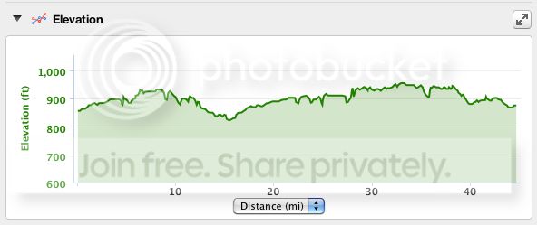
Sorry for the delay, everyone, but this morning's ride was the first one in the past week that was long enough for a rest (read: breakfast) stop. Turning off "auto power down" and turning on "auto pause" seemed to do the trick. No spurious elevation readings at the stop. I left the Garmin on the bike, parked in the sun as usual, and all the report showed was the expected bump in temperature.
Here's the correction-enabled Garmin elevations graph:
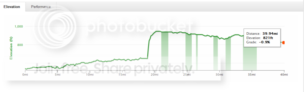
And here's the same from Strava:
Here's the correction-enabled Garmin elevations graph:
And here's the same from Strava: