


Denver, Colorado
 05-06-08, 07:35 AM
#1
Senior Member
Thread Starter
Join Date: Mar 2008
Posts: 206
Mentioned: 0 Post(s)
Tagged: 0 Thread(s)
Quoted: 0 Post(s)
Likes: 0
Liked 0 Times
in
0 Posts
Denver, Colorado
So I am a Georgia cyclist that will be doing a temporary seasonal job for the summer in Granby, Colorado. I was wondering if anybody knew of any good bike shops in west of the Denver area?
I have never been to Colorado either, so I am not familiar with Granby. Can anybody tell me about that area? Granby is a good place since it is centrally located. I have Trial Ridge Pass to the north, Berthoud Pass to the south, and Mount Evans Southeast. What are these roads like?
We got mountains in Georgia but they are no where near as high as where I will be in Colorado. What are the gradient like? I'm sure they are long climbs.
Anyways, any HELP would be greatly appreciated!
Tom
 05-06-08, 09:07 AM
#2

Mountain Goat
Join Date: Apr 2008
Location: Denver, CO
Posts: 2,244
Bikes: Cannondale Synapse 3 Carbon
Mentioned: 0 Post(s)
Tagged: 0 Thread(s)
Quoted: 1 Post(s)
Likes: 0
Liked 0 Times
in
0 Posts
Granby is way west of Denver. Are you looking for shops near Granby? That is about 2 hours of driving from Denver. I don't know of shops up there, but you will likely find something in the Fraser/Winter Park area or up in Dillon/Silverthorn.
05-06-08, 09:31 AM
#3
Senior Member
Thread Starter
Join Date: Mar 2008
Posts: 206
Mentioned: 0 Post(s)
Tagged: 0 Thread(s)
Quoted: 0 Post(s)
Likes: 0
Liked 0 Times
in
0 Posts
Thanks for the info. Hopefully Winter Park has a bike shop.
Still, I was wondering, have you ever ridden up the roads I mentioned? What are they like?
I am just super psyched about climbing Mount Evans this summer.
Thanks and much appreciated Dark13star
Still, I was wondering, have you ever ridden up the roads I mentioned? What are they like?
I am just super psyched about climbing Mount Evans this summer.
Thanks and much appreciated Dark13star
05-06-08, 10:41 AM
#4
cycling for 50 plus yrs
Join Date: Dec 2006
Location: Silverthorne/Lakewood, CO
Posts: 411
Bikes: IF Crown Jewell
Mentioned: 0 Post(s)
Tagged: 0 Thread(s)
Quoted: 1 Post(s)
Likes: 0
Liked 0 Times
in
0 Posts
Winter Park is a haven for summer mtn biking so I'm sure there will be multiple bike shops in WP
and likely Granby.
Check out
Road Biking Colorado: The Statewide Guide (Paperback)
by Michael Seeberg
Book was just featured on local tv show Colorado getaways
https://cbs4denver.com/getaways/color....2.708762.html
Mt Evans is a meer 7000 feet of climbing over 28 miles
Tom Danielson team Slipstream holds the record 1 hr 41:20
https://www.tomdanielson.com/pages/hillclimbs.htm
05-06-08, 11:00 AM
#5
Senior Member
Join Date: Sep 2005
Posts: 1,277
Mentioned: 0 Post(s)
Tagged: 0 Thread(s)
Quoted: 0 Post(s)
Likes: 0
Liked 0 Times
in
0 Posts
05-06-08, 11:02 AM
#6
Senior Member
Join Date: Jul 2003
Location: Boulder, CO
Posts: 8,546
Mentioned: 83 Post(s)
Tagged: 0 Thread(s)
Quoted: 163 Post(s)
Likes: 0
Liked 2 Times
in
2 Posts
There are at least a couple of bike shops in Winter Park, and I have seen big packs of road bikers starting/leaving for group rides from there. Granby is a little tourist town/gateway to RMNP, so it's kind of cutesy and expensive, there's a bunch of restaurants, some hotels, it's on a lake - cute place.
Trail Ridge Road from that side is very long, and has a few harder bits, but is mostly in the 6-8% grade range. Up at the top it gets pretty challenging, as there just isn't much air up there. There's a visitor center near the top, where you can get water and snacks. Berthoud Pass - I've only descended the north side, but it seemed also fairly gradual, not a great shoulder on the descent (northbound) side. The south side of the pass up from Empire is great - just re-paved a couple of years ago, with a huge shoulder.
Also fairly nearby: Loveland Pass, Vail Pass, "the copper triangle" (google it), Squaw/Juniper pass, and there are some more moderate passes out northwest, Rabbit Ears, ?? that I haven't ridden yet. If you get over to the front range, the Peak To Peak highway and all the roads leading up to it & to Estes Park are good, except 119 and 36 which have too much traffic.
Generally, the passes here are long and not very steep. In CO in the summer, there tend to be thunderstorms at high elevations almost every afternoon, so you want to try to get up and off the tops of the passes by mid day. For the first 3 weeks or so you'll really feel the altitude. You need to drink more and use sunscreen at altitude, too.
The attached picture is my bike on a credit card tour, at Milner Pass, where Trail Ridge crosses the continental divide (2000 feet below the summit of the pass).
Have a great summer!!!!
05-06-08, 02:15 PM
#7
Senior Member
Thread Starter
Join Date: Mar 2008
Posts: 206
Mentioned: 0 Post(s)
Tagged: 0 Thread(s)
Quoted: 0 Post(s)
Likes: 0
Liked 0 Times
in
0 Posts
There are at least a couple of bike shops in Winter Park, and I have seen big packs of road bikers starting/leaving for group rides from there. Granby is a little tourist town/gateway to RMNP, so it's kind of cutesy and expensive, there's a bunch of restaurants, some hotels, it's on a lake - cute place.
Trail Ridge Road from that side is very long, and has a few harder bits, but is mostly in the 6-8% grade range. Up at the top it gets pretty challenging, as there just isn't much air up there. There's a visitor center near the top, where you can get water and snacks. Berthoud Pass - I've only descended the north side, but it seemed also fairly gradual, not a great shoulder on the descent (northbound) side. The south side of the pass up from Empire is great - just re-paved a couple of years ago, with a huge shoulder.
Also fairly nearby: Loveland Pass, Vail Pass, "the copper triangle" (google it), Squaw/Juniper pass, and there are some more moderate passes out northwest, Rabbit Ears, ?? that I haven't ridden yet. If you get over to the front range, the Peak To Peak highway and all the roads leading up to it & to Estes Park are good, except 119 and 36 which have too much traffic.
Generally, the passes here are long and not very steep. In CO in the summer, there tend to be thunderstorms at high elevations almost every afternoon, so you want to try to get up and off the tops of the passes by mid day. For the first 3 weeks or so you'll really feel the altitude. You need to drink more and use sunscreen at altitude, too.
The attached picture is my bike on a credit card tour, at Milner Pass, where Trail Ridge crosses the continental divide (2000 feet below the summit of the pass).
Have a great summer!!!!
Trail Ridge Road from that side is very long, and has a few harder bits, but is mostly in the 6-8% grade range. Up at the top it gets pretty challenging, as there just isn't much air up there. There's a visitor center near the top, where you can get water and snacks. Berthoud Pass - I've only descended the north side, but it seemed also fairly gradual, not a great shoulder on the descent (northbound) side. The south side of the pass up from Empire is great - just re-paved a couple of years ago, with a huge shoulder.
Also fairly nearby: Loveland Pass, Vail Pass, "the copper triangle" (google it), Squaw/Juniper pass, and there are some more moderate passes out northwest, Rabbit Ears, ?? that I haven't ridden yet. If you get over to the front range, the Peak To Peak highway and all the roads leading up to it & to Estes Park are good, except 119 and 36 which have too much traffic.
Generally, the passes here are long and not very steep. In CO in the summer, there tend to be thunderstorms at high elevations almost every afternoon, so you want to try to get up and off the tops of the passes by mid day. For the first 3 weeks or so you'll really feel the altitude. You need to drink more and use sunscreen at altitude, too.
The attached picture is my bike on a credit card tour, at Milner Pass, where Trail Ridge crosses the continental divide (2000 feet below the summit of the pass).
Have a great summer!!!!
Thank you so much for telling me about them thunderstorms. We get that in the North Georgia mountains too but probably no where as frequented as in the Rockies.
I plan on bringing my winter clothes just in case. In fact, I am going to bring all my cycling clothing and stuff them all down in my dad's awesome green huge army bag.
Thank you so much for the advice.
Tom
05-06-08, 03:46 PM
#8
Mountain Goat
Join Date: Apr 2008
Location: Denver, CO
Posts: 2,244
Bikes: Cannondale Synapse 3 Carbon
Mentioned: 0 Post(s)
Tagged: 0 Thread(s)
Quoted: 1 Post(s)
Likes: 0
Liked 0 Times
in
0 Posts
I have ridden the area, but more on a mountain bike. I am just back into road cycling and just returned from a ride in the foothills. If you like climbs, you are going to love this summer job.
The warning about the thunderstorms is a good one. Nothing worse than being above tree line with lightning.
The warning about the thunderstorms is a good one. Nothing worse than being above tree line with lightning.
05-06-08, 06:20 PM
#9
Senior Member
Join Date: Oct 2005
Location: Denver
Posts: 1,621
Mentioned: 0 Post(s)
Tagged: 0 Thread(s)
Quoted: 0 Post(s)
Likes: 0
Liked 12 Times
in
12 Posts
Winter Park has much world class singletrack nearby, so if you've ever thought of taking up mountain biking, this would be the time.
Mount Evans is a great ride. Main thing is to be prepared. People have mentioned thunderstorms. Heck, on that ride I would be prepared for anything up to and including the harshest winter conditions imaginable. I carry a lot of warm clothes up that hill and I always end up wearing it all on the way down and usually wishing I had more. Expect insane, radical temperature swings and weather fluctuations from the bottom to the top. Great ride. Bring a ton of food and water, and a camera. If you start to feel unusually nauseous, best thing is to turn around and start down, try again another day.
Also, try Guanella Pass from Georgetown. I think I would rank that as the toughest paved pass in Colorado.
Robert
05-07-08, 07:08 AM
#10
Senior Member
Thread Starter
Join Date: Mar 2008
Posts: 206
Mentioned: 0 Post(s)
Tagged: 0 Thread(s)
Quoted: 0 Post(s)
Likes: 0
Liked 0 Times
in
0 Posts
So what do you suggest on what time I leave from my base?
I will be living 15 miles west of Winter Park and 10 Miles east of Granby. I thought I was going to be living in Winter Park. I have found out that my base is actually Fraser, Colorado. It is at Snow Mountain Ranch.
So this makes my trip to Mount Evans around 70ish miles. So what time should I get to the top? 1pm? I'll be having my days off during the week so there will be much less traffic I guess.
I'm a good climber (I'm 5'4) so that should help. Nonethless, the air is going to be thin up there!
05-07-08, 08:18 AM
#11
Gilpin County Wheelman
Join Date: Apr 2008
Location: Rollinsville Colorado
Posts: 814
Bikes: Parlee Z-4 2001 Fisher Sugar 1 Macalu Ti
Mentioned: 0 Post(s)
Tagged: 0 Thread(s)
Quoted: 0 Post(s)
Likes: 0
Liked 0 Times
in
0 Posts
It is at Snow Mountain Ranch.
Oh man you are in HEAVEN!!
I spend several weekends every winter at snow mtn ranch. the XC skiing is world class. They also host (or did in the past) a KONA 24 hours of Snow Mtn race. From your location you can go North to Granby and then turn west toward Hot sulphur springs for some great road riding. You can turn off to Walden. You can hook up to Steamboat Springs for some big rides. Trail ridge road from West to East is VERY steep and about 10 (?) miles straight up. Be prepared for the altitude. Also for cold nights in Fraser (the ICEBOX of colorado. Says so right on the sign coming into town.)
05-07-08, 08:24 AM
#12
Gilpin County Wheelman
Join Date: Apr 2008
Location: Rollinsville Colorado
Posts: 814
Bikes: Parlee Z-4 2001 Fisher Sugar 1 Macalu Ti
Mentioned: 0 Post(s)
Tagged: 0 Thread(s)
Quoted: 0 Post(s)
Likes: 0
Liked 0 Times
in
0 Posts
Ohh man that;s a huge ride. Over Berthoud Pass (a grunt in itself) then down along I-70 to Idaho Springs. Then you actually begin the REAL climbing. Mt Evans is a bugger. Leave around 4 AM <insert smiley face here>
I would think you might be happier staying in the Fraser Valley and pounding some of those roads, most of which are pretty decent. But, to each their own. We/I might be in this area later in the summer if you want to try and hook up? You can email me if you wish. I've spent a LOT of time in the Fraser Valley. Heck - I live just the other side of the Divde from you. We can both see Devils Thumb given a decent vantage point.
I would think you might be happier staying in the Fraser Valley and pounding some of those roads, most of which are pretty decent. But, to each their own. We/I might be in this area later in the summer if you want to try and hook up? You can email me if you wish. I've spent a LOT of time in the Fraser Valley. Heck - I live just the other side of the Divde from you. We can both see Devils Thumb given a decent vantage point.
05-07-08, 08:02 PM
#13
Senior Member
Thread Starter
Join Date: Mar 2008
Posts: 206
Mentioned: 0 Post(s)
Tagged: 0 Thread(s)
Quoted: 0 Post(s)
Likes: 0
Liked 0 Times
in
0 Posts
It is at Snow Mountain Ranch.
Oh man you are in HEAVEN!!
I spend several weekends every winter at snow mtn ranch. the XC skiing is world class. They also host (or did in the past) a KONA 24 hours of Snow Mtn race. From your location you can go North to Granby and then turn west toward Hot sulphur springs for some great road riding. You can turn off to Walden. You can hook up to Steamboat Springs for some big rides. Trail ridge road from West to East is VERY steep and about 10 (?) miles straight up. Be prepared for the altitude. Also for cold nights in Fraser (the ICEBOX of colorado. Says so right on the sign coming into town.)
Oh man you are in HEAVEN!!
I spend several weekends every winter at snow mtn ranch. the XC skiing is world class. They also host (or did in the past) a KONA 24 hours of Snow Mtn race. From your location you can go North to Granby and then turn west toward Hot sulphur springs for some great road riding. You can turn off to Walden. You can hook up to Steamboat Springs for some big rides. Trail ridge road from West to East is VERY steep and about 10 (?) miles straight up. Be prepared for the altitude. Also for cold nights in Fraser (the ICEBOX of colorado. Says so right on the sign coming into town.)
Icebox huh? Dang. I'll be bringing all my cycling clothing, winter or summer. And a jacket for them cold nights out there.
I don't think I will be able to use the YMCA's van to go to Steamboat Springs or anywhere for that matter. With gas prices as it is, there's no point.
As for Trail Ridge Pass, I plan on doing that a couple of times this summer. Berthoud Pass and Mt. Evan's are closer, so I will be doing those climbs MORE frequently.
05-07-08, 08:05 PM
#14
Senior Member
Thread Starter
Join Date: Mar 2008
Posts: 206
Mentioned: 0 Post(s)
Tagged: 0 Thread(s)
Quoted: 0 Post(s)
Likes: 0
Liked 0 Times
in
0 Posts
Ohh man that's a huge ride. Over Berthoud Pass (a grunt in itself) then down along I-70 to Idaho Springs. Then you actually begin the REAL climbing. Mt Evans is a bugger. Leave around 4 AM <insert smiley face here>
I would think you might be happier staying in the Fraser Valley and pounding some of those roads, most of which are pretty decent. But, to each their own. We/I might be in this area later in the summer if you want to try and hook up? You can email me if you wish. I've spent a LOT of time in the Fraser Valley. Heck - I live just the other side of the Divde from you. We can both see Devils Thumb given a decent vantage point.
I would think you might be happier staying in the Fraser Valley and pounding some of those roads, most of which are pretty decent. But, to each their own. We/I might be in this area later in the summer if you want to try and hook up? You can email me if you wish. I've spent a LOT of time in the Fraser Valley. Heck - I live just the other side of the Divde from you. We can both see Devils Thumb given a decent vantage point.
I plan on riding Fraser Valley on my breaks between work. Intervals. I'll probably just get an hour or two each day for breaks so I'll just kill it to get the most out of my workout.
Also, I'm going to PM you with when I'll be there and for how long. I think I only get two days off per week. Unfortunately, I don't get Saturday and Sunday off. But I can kill it for an hour or so on those days.
I'm like stoked to be going since you said the place is "heaven" haha.
05-07-08, 08:30 PM
#15
Senior Member
Thread Starter
Join Date: Mar 2008
Posts: 206
Mentioned: 0 Post(s)
Tagged: 0 Thread(s)
Quoted: 0 Post(s)
Likes: 0
Liked 0 Times
in
0 Posts
Also, can I ask if I can ride on the dirt roads? Especially on this ride "Johns Pass", which isn't paved but is connected to Berthoud Pass from looking at this map:
https://maps.google.com/maps?f=q&hl=e...,0.160675&z=13
I just think it would be cool to get some 'roubaix' like training in too since there are soo many of them around. Of course, I have no clue what those dirt/gravel roads are like.
Other than that, it would probably be best to stick to the main roads.
05-07-08, 10:01 PM
#16
Senior Member
Join Date: Jul 2003
Location: Boulder, CO
Posts: 8,546
Mentioned: 83 Post(s)
Tagged: 0 Thread(s)
Quoted: 163 Post(s)
Likes: 0
Liked 2 Times
in
2 Posts
Hey really, to get to Mt. Evans, you would climb Berthoud Pass +2000', descend about -4000 feet, climb up to Idaho Springs +1500, climb up to Mt Evans +6600, then you turn around and descend what you climbed, climb what you descended... so maybe 13,000 to 15,000' feet of climbing, very roughly, in 120 miles. And Mt. Evans tops out at 14,150' elevation.
And you actually DO want to be ON TOP of Mt. Evans before noon, because it pretty much hails lightnings rains sleets snows or some combo of those every afternoon.
Trail Ridge Road will be much easier from Frasier. For that you wouldn't need a 4 am start, but 6 would be pretty reasonable. You have maybe 15-20 miles of flatness before starting up the climb, which ascends 3100 feet in 25 miles. That pass tops out at "only" 12,200' but definitely gets some serious weather. My friend and I hitchhiked down off it in a sideways hailstorm, I got blown 8 feet sideways, almost off the road. And that was about 2 hours after that picture I posted above was taken. That was in early September, by the way.
Not trying to put you off at all, you should go check it out - just providing a little been-there-done-that insight for ya.
Don't worry, you'll enjoy it and get plenty of high-mountain bike riding. I don't know if there are dirt roads that you can ride on your road bike, but there are tons of MTB trails and I bet you can rent a great bike in Winter Park.
05-08-08, 12:09 AM
#17
Mountain Goat
Join Date: Apr 2008
Location: Denver, CO
Posts: 2,244
Bikes: Cannondale Synapse 3 Carbon
Mentioned: 0 Post(s)
Tagged: 0 Thread(s)
Quoted: 1 Post(s)
Likes: 0
Liked 0 Times
in
0 Posts
You do need to be off the summit of Evans by noon, and even if you could do that from Fraser, you would still need to cross Berthould pass during storm hours. As you plan your rides in Colorado, make sure you do it on a topo map. Mileage is nothing without considering altitude.
Also, you will love your experience and you may never go home. Just don't do anything crazy.
05-08-08, 03:21 AM
#18
Senior Member
Join Date: Oct 2005
Location: Denver
Posts: 1,621
Mentioned: 0 Post(s)
Tagged: 0 Thread(s)
Quoted: 0 Post(s)
Likes: 0
Liked 12 Times
in
12 Posts
So what do you suggest on what time I leave from my base?
I will be living 15 miles west of Winter Park and 10 Miles east of Granby. I thought I was going to be living in Winter Park. I have found out that my base is actually Fraser, Colorado. It is at Snow Mountain Ranch.
So this makes my trip to Mount Evans around 70ish miles. So what time should I get to the top? 1pm? I'll be having my days off during the week so there will be much less traffic I guess.
I'm a good climber (I'm 5'4) so that should help. Nonethless, the air is going to be thin up there!
I will be living 15 miles west of Winter Park and 10 Miles east of Granby. I thought I was going to be living in Winter Park. I have found out that my base is actually Fraser, Colorado. It is at Snow Mountain Ranch.
So this makes my trip to Mount Evans around 70ish miles. So what time should I get to the top? 1pm? I'll be having my days off during the week so there will be much less traffic I guess.
I'm a good climber (I'm 5'4) so that should help. Nonethless, the air is going to be thin up there!
I know someone who once tried to ride from Denver to the top of Evans and back. Certainly looks doable on the map. This guy was one of the stronger rando/audax riders in the state. He bonked out hard and called his girlfriend for a rescue.
What others have said is true. Evans is a hard ride if you drive to Idaho Springs and start there, so riding to the base of Evans from just about anywhere puts it well into the epic category. So my suggestion is that you somehow steal a car and do this ride, get a carpool going or something, as it is a must.
From a Colorado native, I don't necessarily buy this suggestion that you have to be to the top of the mountain by noon or one or whatever. I mean, to be absolutely sure that you get to the top before typical afternoon thunderstorms move in, sure, get up and down as early as possible. But to be honest if I subscribed to that notion I would never get to the top of anything. Let's just say I'm not a morning person. I like to start my rides when the rocks are warm, at the earliest. This means I end up starting a lot of rides in the mountains at the time when most folks are finishing up. Quite often, the weather pattern is extremely stable through the afternoon and into the night and I take advantage of that. I've done Evans multiple times and hiked several Colorado 14ers in the relatively late afternoon under gorgeous skies. Also, you'll find that a squall will often come through in the afternoon and give way to perfect conditions for the few hours until sunset -- ideal riding weather. That said I take Colorado weather very seriously. Hypothermia is a very real possibility for the ill-equipped on a ride like Evans. I like to carry a lot of clothing on these climbs, and I'm not afraid to turn around if things get ugly. I've been hit reeeal hard by weather near Fraser, btw. I distinctly remember sleet. Just carry a waterproof jacket and other goodies around wherever you go so you won't have to worry about it.
I predict you'll start mtn biking within a few weeks of arrival and forget all about Evans anyway.
Robert
05-08-08, 09:04 AM
#19
Senior Member
Join Date: Sep 2005
Posts: 1,277
Mentioned: 0 Post(s)
Tagged: 0 Thread(s)
Quoted: 0 Post(s)
Likes: 0
Liked 0 Times
in
0 Posts
A bunch of guys do this annually for the Annual Hillclimb race, they are nuts in addition to being extreme distance sports guys, but it is certainly doable. One of them lives in my neighborhood, he is very tiny and very very fit.
05-08-08, 09:08 AM
#20

Mad bike riding scientist

Join Date: Nov 2004
Location: Denver, CO
Posts: 27,362
Bikes: Some silver ones, a red one, a black and orange one, and a few titanium ones
Mentioned: 152 Post(s)
Tagged: 1 Thread(s)
Quoted: 6219 Post(s)
Liked 4,218 Times
in
2,365 Posts
Also, can I ask if I can ride on the dirt roads? Especially on this ride "Johns Pass", which isn't paved but is connected to Berthoud Pass from looking at this map:
https://maps.google.com/maps?f=q&hl=e...,0.160675&z=13
I just think it would be cool to get some 'roubaix' like training in too since there are soo many of them around. Of course, I have no clue what those dirt/gravel roads are like.
Other than that, it would probably be best to stick to the main roads.
https://maps.google.com/maps?f=q&hl=e...,0.160675&z=13
I just think it would be cool to get some 'roubaix' like training in too since there are soo many of them around. Of course, I have no clue what those dirt/gravel roads are like.
Other than that, it would probably be best to stick to the main roads.
A better choice would be 4-Bar-4 Road (County Rd 5) which is a little better maintained and could be doable on a road bike.
Generally speaking, however, a road bike is mostly useless in the Winter Park area. There's only one paved road in the area (US40) and that can get real boring once you've done the ride to the top of Berthoud Pass and Trail Ridge. Better to rent or take a mountain bike. You'll get more use out of it.
If you aren't a mountain biker, there are plenty of routes that are fairly easy in the area that will get your feet wet...so to speak. Rollins Pass is very easy and very spectacular, especially at the top. Go a little over the top down to the Devil's Slide Trestles to really scare the pants off you
 Not many places you can look 1200 feet straight down without a rope.
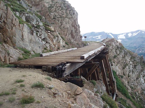
That bridge is 15 feet wide but when you ride it, it feels like a 2x4
4-Bar-4 Road is pretty easy too as is the road through the Experimental Forest.
__________________
Stuart Black
Plan Epsilon Around Lake Michigan in the era of Covid
Old School�When It Wasn�t Ancient bikepacking
Gold Fever Three days of dirt in Colorado
Pokin' around the Poconos A cold ride around Lake Erie
Dinosaurs in Colorado A mountain bike guide to the Purgatory Canyon dinosaur trackway
Solo Without Pie. The search for pie in the Midwest.
Picking the Scablands. Washington and Oregon, 2005. Pie and spiders on the Columbia River!
05-08-08, 10:39 AM
#21
Senior Member
Thread Starter
Join Date: Mar 2008
Posts: 206
Mentioned: 0 Post(s)
Tagged: 0 Thread(s)
Quoted: 0 Post(s)
Likes: 0
Liked 0 Times
in
0 Posts
'Dirt' roads in Colorado are more along the lines of 'rock' roads. Jones Pass, in particular, is steep and very rugged...and not that spectacular really. Past Henderson Mine the road is very rugged.
A better choice would be 4-Bar-4 Road (County Rd 5) which is a little better maintained and could be doable on a road bike.
Generally speaking, however, a road bike is mostly useless in the Winter Park area. There's only one paved road in the area (US40) and that can get real boring once you've done the ride to the top of Berthoud Pass and Trail Ridge. Better to rent or take a mountain bike. You'll get more use out of it.
If you aren't a mountain biker, there are plenty of routes that are fairly easy in the area that will get your feet wet...so to speak. Rollins Pass is very easy and very spectacular, especially at the top. Go a little over the top down to the Devil's Slide Trestles to really scare the pants off you Not many places you can look 1200 feet straight down without a rope.
That bridge is 15 feet wide but when you ride it, it feels like a 2x4
4-Bar-4 Road is pretty easy too as is the road through the Experimental Forest.
A better choice would be 4-Bar-4 Road (County Rd 5) which is a little better maintained and could be doable on a road bike.
Generally speaking, however, a road bike is mostly useless in the Winter Park area. There's only one paved road in the area (US40) and that can get real boring once you've done the ride to the top of Berthoud Pass and Trail Ridge. Better to rent or take a mountain bike. You'll get more use out of it.
If you aren't a mountain biker, there are plenty of routes that are fairly easy in the area that will get your feet wet...so to speak. Rollins Pass is very easy and very spectacular, especially at the top. Go a little over the top down to the Devil's Slide Trestles to really scare the pants off you
Not many places you can look 1200 feet straight down without a rope. That bridge is 15 feet wide but when you ride it, it feels like a 2x4
4-Bar-4 Road is pretty easy too as is the road through the Experimental Forest.
I'v been looking at Flickr.com photos of Rollins Pass and it totally looks awesome to do. Roubaix like roads? Def baby!
I am trying to find 4-Bar-4 Road and Experimental Forest on google maps. Can't find them. I see Rollins Pass. I just put that on my mapmyride and wow, looks like a steep climb. 10 mile climb or so.
05-08-08, 10:56 AM
#22
Senior Member
Join Date: Sep 2005
Posts: 1,277
Mentioned: 0 Post(s)
Tagged: 0 Thread(s)
Quoted: 0 Post(s)
Likes: 0
Liked 0 Times
in
0 Posts
Just remember, trains went up it, can't be that steep. I love old railroad passes, they are really nice gentle grades to climb, Boreas to Breckenridge is another great old railroad pass, again, dirt road now.
+1 on getting a MTB, its Winter Park, hundreds of miles of great trails.
05-08-08, 12:47 PM
#23
Gilpin County Wheelman
Join Date: Apr 2008
Location: Rollinsville Colorado
Posts: 814
Bikes: Parlee Z-4 2001 Fisher Sugar 1 Macalu Ti
Mentioned: 0 Post(s)
Tagged: 0 Thread(s)
Quoted: 0 Post(s)
Likes: 0
Liked 0 Times
in
0 Posts
The Expiremental Forest is shown on any of the local trails maps you can get in Winter Park. Those dirt roads (St Louis Creek and Vasquez Creek etc) are fairly well maintained and could probably be ridden on a road bike. I've always used a mtn bike though, especially since you can drop off of them in a number of places and hit some sweet singing single track.
I'm guessing its probably snowing in Fraser today. We've had several squalls come through here. I thought the sun was finally out and took the bike out. 20 minutes later? 10-15 mph winds and sideways snow.
I've done the ride over Rollins Pass from east to west a few times. Again, I would suggest a mtn bike. the road on the east side is not maintained other than it gets plowed once a year. I don't think they plow the west side at all. I know one year we had to walk through ice fields above the trestles for over a half mile.
Lastly - you can probably get a decent mtn bike from the folks at Snow Mtn. And probably for free as part of your work gig.
05-08-08, 01:44 PM
#24
Mad bike riding scientist
Join Date: Nov 2004
Location: Denver, CO
Posts: 27,362
Bikes: Some silver ones, a red one, a black and orange one, and a few titanium ones
Mentioned: 152 Post(s)
Tagged: 1 Thread(s)
Quoted: 6219 Post(s)
Liked 4,218 Times
in
2,365 Posts
Rollins Pass totally doable by road bike but I gotta say that I must be careful going over that bridge. How long is the bridge?
I'v been looking at Flickr.com photos of Rollins Pass and it totally looks awesome to do. Roubaix like roads? Def baby!
I am trying to find 4-Bar-4 Road and Experimental Forest on google maps. Can't find them. I see Rollins Pass. I just put that on my mapmyride and wow, looks like a steep climb. 10 mile climb or so.
The Experimental forest road is County road 72 on the south side of Fraser. It connects to Vasquez Road in Winter Park. 4-Bar-4 is County Road 5 on the north side of town and connects up with US40 near Pole Creek Golf course. Here's a 30 mile (roughly) route over to Parshal. You could also connect it up to ride over Ute Pass to Green Mountain Res.
__________________
Stuart Black
Plan Epsilon Around Lake Michigan in the era of Covid
Old School�When It Wasn�t Ancient bikepacking
Gold Fever Three days of dirt in Colorado
Pokin' around the Poconos A cold ride around Lake Erie
Dinosaurs in Colorado A mountain bike guide to the Purgatory Canyon dinosaur trackway
Solo Without Pie. The search for pie in the Midwest.
Picking the Scablands. Washington and Oregon, 2005. Pie and spiders on the Columbia River!
Stuart Black
Plan Epsilon Around Lake Michigan in the era of Covid
Old School�When It Wasn�t Ancient bikepacking
Gold Fever Three days of dirt in Colorado
Pokin' around the Poconos A cold ride around Lake Erie
Dinosaurs in Colorado A mountain bike guide to the Purgatory Canyon dinosaur trackway
Solo Without Pie. The search for pie in the Midwest.
Picking the Scablands. Washington and Oregon, 2005. Pie and spiders on the Columbia River!
05-08-08, 01:52 PM
#25
Senior Member
Thread Starter
Join Date: Mar 2008
Posts: 206
Mentioned: 0 Post(s)
Tagged: 0 Thread(s)
Quoted: 0 Post(s)
Likes: 0
Liked 0 Times
in
0 Posts
The Expiremental Forest is shown on any of the local trails maps you can get in Winter Park. Those dirt roads (St Louis Creek and Vasquez Creek etc) are fairly well maintained and could probably be ridden on a road bike. I've always used a mtn bike though, especially since you can drop off of them in a number of places and hit some sweet singing single track.
I'm guessing its probably snowing in Fraser today. We've had several squalls come through here. I thought the sun was finally out and took the bike out. 20 minutes later? 10-15 mph winds and sideways snow.
I've done the ride over Rollins Pass from east to west a few times. Again, I would suggest a mtn bike. the road on the east side is not maintained other than it gets plowed once a year. I don't think they plow the west side at all. I know one year we had to walk through ice fields above the trestles for over a half mile.
Lastly - you can probably get a decent mtn bike from the folks at Snow Mtn. And probably for free as part of your work gig.
I'm guessing its probably snowing in Fraser today. We've had several squalls come through here. I thought the sun was finally out and took the bike out. 20 minutes later? 10-15 mph winds and sideways snow.
I've done the ride over Rollins Pass from east to west a few times. Again, I would suggest a mtn bike. the road on the east side is not maintained other than it gets plowed once a year. I don't think they plow the west side at all. I know one year we had to walk through ice fields above the trestles for over a half mile.
Lastly - you can probably get a decent mtn bike from the folks at Snow Mtn. And probably for free as part of your work gig.
I'll def be renting a MTB bike this summer since this is pretty much heaven for MTBer's.
I have been looking at Rollins Pass photos from Flickr and I am just droooling.