


The last, final, complete discussion: Which Garmin?
 03-21-17, 05:09 PM
#1
Senior Member
Thread Starter
The last, final, complete discussion: Which Garmin?
I know, I know....this has been discussed ad nauseam. Let me tell you where I am coming from: I have completed (and registered for a couple more) 100km rides that are run locally where I live. I have done these with just the hard-copy cue sheet. After this weekend, I will NOT go on one of these rides without a GPS/bike computer again. I got lost in 28 degree weather and added a nice distance to the 100km route. So, I plan to do more 100km and try a 200km also. Maybe, maybe, some day do a 400km. I am not racing...I guess its slightly competitive, touring, see how- you-do kind of riding. I am currently do maybe 60 miles a week. In the future, I would like to get a power meter, maybe stages.(Probably far more tech than I need.)
So, navigation, clear, easy to see navigation is important. what I am confused about is pre loading maps versus having a device that works like a car GPs.
What Garmin would be best? I am not going into the price range of the Garmin 1000. So, I narrowed it down to the 520 or 800 series.
What would be best for the type of rider I am ?
Thanks.

 03-21-17, 05:20 PM
#3
Senior Member
Join Date: Oct 2004
Location: CA SF Bay Area
Posts: 476
Bikes: 2014 CDale EVO, 2007 System Six, 2004 Litespeed Solano, 2002 Burley Duet
Mentioned: 3 Post(s)
Tagged: 0 Thread(s)
Quoted: 92 Post(s)
Likes: 0
Liked 0 Times
in
0 Posts
If you want a moving map, you need the 800 or 1000 series. If you can find a used 705 in good shape, it will also do what you need.
I have heard good things about the new Wahoo GPS units also.
I use Ride With GPS for building and loading course maps. User interface for building maps is a little easier to use than Strava. You build the course then load it as a GPX file onto the GPS. The process is not that hard after you do it a couple times.
Battery life might be an issue at 400KM. I was able to barely get 12 hours out of my 705 and the best I have done with my 1000 is around seven hours. A 1500-2500 mAh battery is supposed to be a good option to extend the battery life.
03-21-17, 07:26 PM
#4
Senior Member
Join Date: Sep 2007
Location: Far beyond the pale horizon.
Posts: 14,272
Mentioned: 31 Post(s)
Tagged: 0 Thread(s)
Quoted: 4257 Post(s)
Liked 1,355 Times
in
941 Posts
The Wahoo units is basically equivalent to the Garmin 520. The turn notifications might be a bit better and the map display is better (but no street names).
The 520 has a basic map (less detail than the Wahoo). You can install more detailed maps on the 520 but they can't be too big.
The turn notifications of the 800, 810, 820, 1000 are better.
The newer units aren't really any better for navigation than the old 800.
I use a 800 and generally keep an eye on the map. That way, you know what is coming up and can see that you are off course if you happen to miss the device telling you to make a turn.
Last edited by njkayaker; 03-21-17 at 07:37 PM.
03-21-17, 07:45 PM
#5
Thread Killer
Join Date: Aug 2008
Location: Ann Arbor, MI
Posts: 12,440
Bikes: 15 Kinesis Racelight 4S, 76 Motebecane Gran Jubil�e, 17 Dedacciai Gladiatore2, 12 Breezer Venturi, 09 Dahon Mariner, 12 Mercier Nano, 95 DeKerf Team SL, 19 Tern Rally, 21 Breezer Doppler Cafe+, 19 T-Lab X3, 91 Serotta CII, 23 3T Strada
Mentioned: 30 Post(s)
Tagged: 0 Thread(s)
Quoted: 3143 Post(s)
Liked 1,707 Times
in
1,031 Posts
I'd go Wahoo ELEMNT. Upload routes from RWGPS, and do quick, on-the-fly route mods to the unit from my smartphone.
Obviously not a good choice for backcountry wilderness rambling when you want to reroute and no cell service is available, but otherwise, the good basemaps and 17hr battery life make the ELEMNT attractive.
Obviously not a good choice for backcountry wilderness rambling when you want to reroute and no cell service is available, but otherwise, the good basemaps and 17hr battery life make the ELEMNT attractive.
03-21-17, 07:47 PM
#6
Senior Member
Join Date: Sep 2007
Location: Far beyond the pale horizon.
Posts: 14,272
Mentioned: 31 Post(s)
Tagged: 0 Thread(s)
Quoted: 4257 Post(s)
Liked 1,355 Times
in
941 Posts
When using a track file, you get turn notifications. It take some experience getting used to using it, but, in my opinion, it works well (I've done long distance night time rides). Keeping an eye on the map makes the navigation more reliable.
They sort-of work like a car GPS, but you have to pay more attention than you need-to in a car.
03-21-17, 09:05 PM
#7
Junior Member
You could carry a battery pack and cable and charge it mid ride if you have time to get it setup. I have a 5500ma battery pack I have on my longer rides when I have my camera mounted, worked like a charm. I also have a 15,00ma pack I plan on bringing in my seat pack when I do the MS150 later this year to keep my phone, bike computer, and phone charged.
03-21-17, 10:04 PM
#9
Senior Member
I'd go Wahoo ELEMNT. Upload routes from RWGPS, and do quick, on-the-fly route mods to the unit from my smartphone.
Obviously not a good choice for backcountry wilderness rambling when you want to reroute and no cell service is available, but otherwise, the good basemaps and 17hr battery life make the ELEMNT attractive.
Obviously not a good choice for backcountry wilderness rambling when you want to reroute and no cell service is available, but otherwise, the good basemaps and 17hr battery life make the ELEMNT attractive.
03-21-17, 11:00 PM
#10
Thread Killer
Join Date: Aug 2008
Location: Ann Arbor, MI
Posts: 12,440
Bikes: 15 Kinesis Racelight 4S, 76 Motebecane Gran Jubil�e, 17 Dedacciai Gladiatore2, 12 Breezer Venturi, 09 Dahon Mariner, 12 Mercier Nano, 95 DeKerf Team SL, 19 Tern Rally, 21 Breezer Doppler Cafe+, 19 T-Lab X3, 91 Serotta CII, 23 3T Strada
Mentioned: 30 Post(s)
Tagged: 0 Thread(s)
Quoted: 3143 Post(s)
Liked 1,707 Times
in
1,031 Posts
So for example, if you fail to take a turn and go off route, you can use the map to navigate back to the course, but ELEMNT will not work like a car GPS and tell you how to do it. It's like breadcrumb nav, just with a decent map (no street names, though).
Or, in an off course situation, you fould pull out the phone, reroute to a destination, and send to ELEMNT. That won't help you get back on the old course, though.
03-22-17, 12:57 AM
#11
Senior Member

Garmin eTrex.
If you plan to do 400km rides, you need something that does not by charge via a USB port. The eTrex takes AA batteries. This is the unit that most ultra distance riders use.
If you plan to do 400km rides, you need something that does not by charge via a USB port. The eTrex takes AA batteries. This is the unit that most ultra distance riders use.
03-22-17, 03:42 AM
#12
Senior Member

I'd go Wahoo ELEMNT. Upload routes from RWGPS, and do quick, on-the-fly route mods to the unit from my smartphone.
Obviously not a good choice for backcountry wilderness rambling when you want to reroute and no cell service is available, but otherwise, the good basemaps and 17hr battery life make the ELEMNT attractive.
Obviously not a good choice for backcountry wilderness rambling when you want to reroute and no cell service is available, but otherwise, the good basemaps and 17hr battery life make the ELEMNT attractive.
03-22-17, 05:41 AM
#13
Thread Killer
Join Date: Aug 2008
Location: Ann Arbor, MI
Posts: 12,440
Bikes: 15 Kinesis Racelight 4S, 76 Motebecane Gran Jubil�e, 17 Dedacciai Gladiatore2, 12 Breezer Venturi, 09 Dahon Mariner, 12 Mercier Nano, 95 DeKerf Team SL, 19 Tern Rally, 21 Breezer Doppler Cafe+, 19 T-Lab X3, 91 Serotta CII, 23 3T Strada
Mentioned: 30 Post(s)
Tagged: 0 Thread(s)
Quoted: 3143 Post(s)
Liked 1,707 Times
in
1,031 Posts
03-22-17, 06:02 AM
#14
Thread Killer
Join Date: Aug 2008
Location: Ann Arbor, MI
Posts: 12,440
Bikes: 15 Kinesis Racelight 4S, 76 Motebecane Gran Jubil�e, 17 Dedacciai Gladiatore2, 12 Breezer Venturi, 09 Dahon Mariner, 12 Mercier Nano, 95 DeKerf Team SL, 19 Tern Rally, 21 Breezer Doppler Cafe+, 19 T-Lab X3, 91 Serotta CII, 23 3T Strada
Mentioned: 30 Post(s)
Tagged: 0 Thread(s)
Quoted: 3143 Post(s)
Liked 1,707 Times
in
1,031 Posts
These two pics do a good job, probably, of helping understand how the 520 and ELEMNT/BOLT do maps differently.

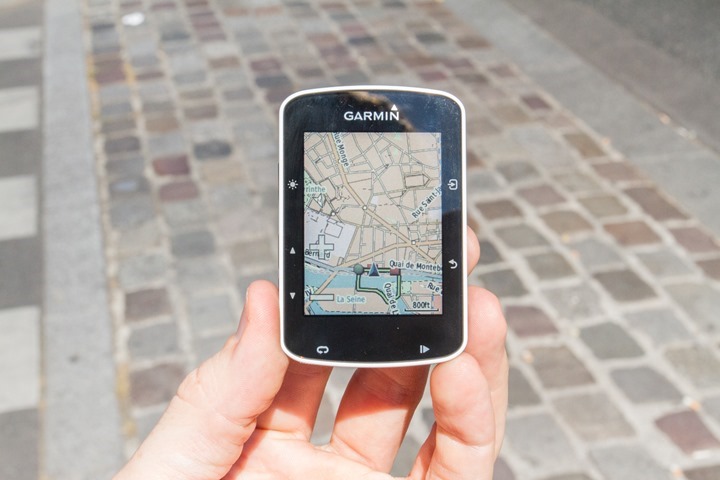
I think there's no doubt the Garmin maps are nicer, but Wahoo has some nice features to keep you on track, which I think for a certain segment of riders is really all they're looking for, so the total ELEMNT package, including lower pricing, is pretty attractive.
Similarly, advanced map users, like tourers or randos, would probably prefer the 520 feature set.
It all depends on the rider's needs; map detail is only sacrificed if you'd otherwise use it, you know?
03-22-17, 08:10 AM
#16
Senior Member
Join Date: Sep 2014
Location: Northeastern MA, USA
Posts: 1,678
Bikes: Garmin/Tacx Bike Smart
Mentioned: 3 Post(s)
Tagged: 0 Thread(s)
Quoted: 646 Post(s)
Liked 289 Times
in
191 Posts
One more note: don't discount support. I recently purchased an Edge 25, but have never been able to load an activity. Garmin has acknowledged the issue but offered no date for a fix. I'm moving to a Bolt.
03-22-17, 08:17 AM
#18
Senior Member
Join Date: Sep 2007
Location: Far beyond the pale horizon.
Posts: 14,272
Mentioned: 31 Post(s)
Tagged: 0 Thread(s)
Quoted: 4257 Post(s)
Liked 1,355 Times
in
941 Posts
A fair number charge by the USB port. The main problem with that is if it's wet. The eTrex is big.
03-22-17, 08:23 AM
#19
pluralis majestatis
Join Date: Feb 2004
Location: you rope
Posts: 4,206
Bikes: a DuhRosa
Mentioned: 8 Post(s)
Tagged: 0 Thread(s)
Quoted: 537 Post(s)
Likes: 0
Liked 2 Times
in
2 Posts
its very easy to load detailed maps to 520. thats not the problem
problem is tiny display, essentially no working control (pan, zoom, etc), terrible rate of display or refresh, finnicky notification settings and control...
when i go on a new route with my 520, i still bring a miniature cue sheet or use my phone at breaks
problem is tiny display, essentially no working control (pan, zoom, etc), terrible rate of display or refresh, finnicky notification settings and control...
when i go on a new route with my 520, i still bring a miniature cue sheet or use my phone at breaks
03-22-17, 08:28 AM
#20

pan y agua

Join Date: Aug 2005
Location: Jacksonville
Posts: 31,303
Bikes: Willier Zero 7; Merlin Extralight; Calfee Dragonfly tandem, Calfee Adventure tandem; Cervelo P2; Motebecane Ti Fly 29er; Motebecanne Phantom Cross; Schwinn Paramount Track bike
Mentioned: 17 Post(s)
Tagged: 0 Thread(s)
Quoted: 1447 Post(s)
Liked 727 Times
in
372 Posts
DC Rainmaker has a nice comparison between the 1000 and 820.
There's not much the 1000 does that the 820 doesn't.
My 1000 fell off and got run over by a car.
I'm going to replace it with an 820 because I don't see anything the 1000 does and the 820 doesn't that I care about.
I imagine the next iteration of the 1000 will push it out further, but with the 820 being more recently released than the 1000, the gap between the 1000 series and 800 series seems pretty small.
__________________
You could fall off a cliff and die.
You could get lost and die.
You could hit a tree and die.
OR YOU COULD STAY HOME AND FALL OFF THE COUCH AND DIE.
You could fall off a cliff and die.
You could get lost and die.
You could hit a tree and die.
OR YOU COULD STAY HOME AND FALL OFF THE COUCH AND DIE.
03-22-17, 08:30 AM
#21
Senior Member
Join Date: Sep 2007
Location: Far beyond the pale horizon.
Posts: 14,272
Mentioned: 31 Post(s)
Tagged: 0 Thread(s)
Quoted: 4257 Post(s)
Liked 1,355 Times
in
941 Posts
People should buy the unit that is best for them rather than worrying about a small difference in price.
The Garmins (Edges and eTreks) let you install your own maps. Devices from other companies (Mio, Bryton, Wahoo) appear not to.
Details like water, improved indications of road classes, and street names provide a better sense of where you are.
I've worked out detours on the fly with the Garmin. That would be harder to do with the Wahoo.
I've used the Garmin for street names when using paper cuesheets.s.
Last edited by njkayaker; 03-22-17 at 08:54 AM.
03-22-17, 08:42 AM
#22
Senior Member
Join Date: Sep 2007
Location: Far beyond the pale horizon.
Posts: 14,272
Mentioned: 31 Post(s)
Tagged: 0 Thread(s)
Quoted: 4257 Post(s)
Liked 1,355 Times
in
941 Posts
DC Rainmaker has a nice comparison between the 1000 and 820.
There's not much the 1000 does that the 820 doesn't.
My 1000 fell off and got run over by a car.
I'm going to replace it with an 820 because I don't see anything the 1000 does and the 820 doesn't that I care about.
I imagine the next iteration of the 1000 will push it out further, but with the 820 being more recently released than the 1000, the gap between the 1000 series and 800 series seems pretty small.
The 1000 has a bigger/better screen, which helps with using the map (the 820's screen is a bit small). The computer in the 1000 appears to be faster than that in the 800/810 (don't know about the 820), which makes updating the screen faster.
03-22-17, 08:47 AM
#23
Senior Member
Join Date: Mar 2010
Location: Seattle, WA
Posts: 23,208
Mentioned: 89 Post(s)
Tagged: 0 Thread(s)
Quoted: 18883 Post(s)
Liked 10,646 Times
in
6,054 Posts
Fenix 5X. Best Garmin on the market.

03-22-17, 08:51 AM
#24
Thread Killer
Join Date: Aug 2008
Location: Ann Arbor, MI
Posts: 12,440
Bikes: 15 Kinesis Racelight 4S, 76 Motebecane Gran Jubil�e, 17 Dedacciai Gladiatore2, 12 Breezer Venturi, 09 Dahon Mariner, 12 Mercier Nano, 95 DeKerf Team SL, 19 Tern Rally, 21 Breezer Doppler Cafe+, 19 T-Lab X3, 91 Serotta CII, 23 3T Strada
Mentioned: 30 Post(s)
Tagged: 0 Thread(s)
Quoted: 3143 Post(s)
Liked 1,707 Times
in
1,031 Posts
That was useful.
The Elmnt is $330 and the Bolt is $250. The Garmin 520 is $300 (the Garmin unit that mostly matches the Wahoo products). (If you are patient, you can get the 1000 for $1000.)
People should buy the unit that is best for them rather than worrying about a small difference in price.
People really interested in navigation should forgo the 520 (and the Wahoo units). The 520 only displays maps and has very limited room for them.
Better maps give you more options for navigation.
03-22-17, 09:01 AM
#25
Senior Member
Join Date: Sep 2007
Location: Far beyond the pale horizon.
Posts: 14,272
Mentioned: 31 Post(s)
Tagged: 0 Thread(s)
Quoted: 4257 Post(s)
Liked 1,355 Times
in
941 Posts
I agree with you on all those points, especially about those "really interested in navigation" forgoing the 520 and Wahoo units; I didn't realize the 520 has "essentially no working pan or zoom" as @redfooj points out, which would limit it's appeal for, say, ride leaders building routes.
Many riders with the "fancy" Garmins don't use them for navigation. Of those who do, some might not use the devices very effectively.
Last edited by njkayaker; 03-22-17 at 09:10 AM.