


Google Earth..
 07-07-05, 07:25 PM
#1
�ber member!
Thread Starter

Join Date: Sep 2001
Location: Sunnyvale, CA.
Posts: 993
Bikes: 2004 Albert Eisentraut
Mentioned: 0 Post(s)
Tagged: 0 Thread(s)
Quoted: 0 Post(s)
Likes: 0
Liked 0 Times
in
0 Posts
Google Earth..
Very Cool!!! Very! based on Keyhole technology. it allows you to fly over any place in the world (resolution may vary).
I put did a fly over a route I ride my bike on, the Montebello climb, an captured this image.. it is very realistic considering it is rendering 3D dimensions from altitude data it has.. You can actually see rows of vines at the top of the climb. VERY COOL!
There are ways to overlay other images (like a route) and also connect it to a GPS.. the possibilities are limitless..
earth.google.com
 07-07-05, 07:51 PM
#2
pAIYILI

Join Date: Jun 2005
Location: Pennsylvania, PA USA
Posts: 130
Bikes: Specialized Crosroads Sport (Hybrid)
Mentioned: 0 Post(s)
Tagged: 0 Thread(s)
Quoted: 0 Post(s)
Likes: 0
Liked 0 Times
in
0 Posts
Downloaded and installed last night, used it today to get directions for a trip. I could play with this thing for hours. I'd like to see some useful mapping program features like "preferred roads", but first impression is the same as yours, VERY COOL!
07-07-05, 08:09 PM
#3
Senior Member
Join Date: Dec 2004
Location: Athens, Ohio
Posts: 5,104
Bikes: Custom Custom Custom
Mentioned: 0 Post(s)
Tagged: 0 Thread(s)
Quoted: 1 Post(s)
Likes: 0
Liked 1 Time
in
1 Post
too bad my area isn't mapped out clearly enough. Its a pity since we have really nice hills.
07-07-05, 08:24 PM
#4
Nonsense
Join Date: Sep 2004
Location: Vagabond
Posts: 13,918
Bikes: Affirmative
Mentioned: 0 Post(s)
Tagged: 0 Thread(s)
Quoted: 880 Post(s)
Liked 541 Times
in
237 Posts
Wow, that's pretty awesome. Do you need to get Google Earth Plus to do the 3d thing and map out routes/total elevation climbed?
07-07-05, 08:34 PM
#6
�ber member!
Thread Starter
Join Date: Sep 2001
Location: Sunnyvale, CA.
Posts: 993
Bikes: 2004 Albert Eisentraut
Mentioned: 0 Post(s)
Tagged: 0 Thread(s)
Quoted: 0 Post(s)
Likes: 0
Liked 0 Times
in
0 Posts
Originally Posted by PenguinDeD
Wow, that's pretty awesome. Do you need to get Google Earth Plus to do the 3d thing and map out routes/total elevation climbed?
You don't need to get Plus. I have the free version and the picture I posted is from the free version.. If this eventually evolves into a mapping software that I could use to plan my bike routes, then I would gladly pay.
07-07-05, 08:37 PM
#7

Meow!

Join Date: Sep 2004
Location: Riverside, California
Posts: 6,019
Bikes: Trek 2100 Road Bike, Full DA10, Cervelo P2K TT bike, Full DA10, Giant Boulder Steel Commuter
Mentioned: 0 Post(s)
Tagged: 0 Thread(s)
Quoted: 0 Post(s)
Likes: 0
Liked 0 Times
in
0 Posts
very cool!
__________________
Just your average club rider... :)
Just your average club rider... :)
07-07-05, 08:46 PM
#9
Senior Member
Join Date: Aug 2004
Location: Eastern Long Island
Posts: 247
Bikes: DeBernardi road ... Pedal Force RS2....Gary Fisher mountain
Mentioned: 0 Post(s)
Tagged: 0 Thread(s)
Quoted: 0 Post(s)
Likes: 0
Liked 0 Times
in
0 Posts
Damn....I just wasted 50 minutes playing with this software and now my kids want me to log off so they can look up all their sites.....
Thanks for the link Sorebutt!
Thanks for the link Sorebutt!
07-07-05, 08:56 PM
#11
�ber member!
Thread Starter
Join Date: Sep 2001
Location: Sunnyvale, CA.
Posts: 993
Bikes: 2004 Albert Eisentraut
Mentioned: 0 Post(s)
Tagged: 0 Thread(s)
Quoted: 0 Post(s)
Likes: 0
Liked 0 Times
in
0 Posts
This map will show you (in yellow) what parts of North America are covered with High Rez images..
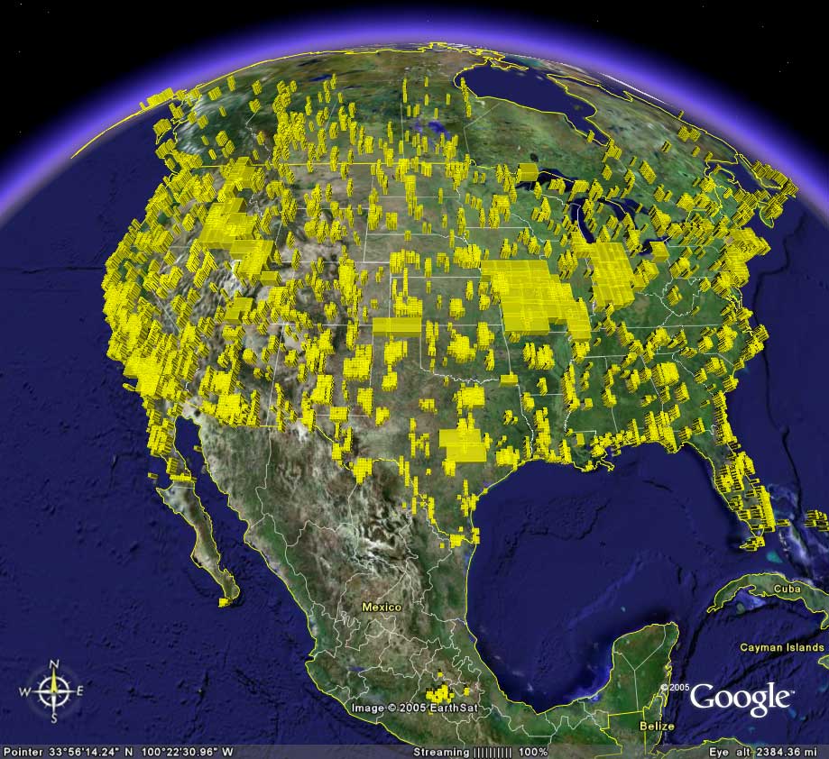
and for the rest of the world
and for the rest of the world
07-07-05, 09:14 PM
#12
Campy or bust :p

Join Date: Oct 2004
Location: Knoxville, TN
Posts: 3,139
Bikes: Surly Karate Monkey commuter build
Mentioned: 0 Post(s)
Tagged: 0 Thread(s)
Quoted: 0 Post(s)
Likes: 0
Liked 0 Times
in
0 Posts
I like how it also tells you altitude of a given point on the map... I used the "measure" tool to find distance and then checked the altitude at point A and point B... and found the percent grade of a couple of roads around here that I've climbed. Very neat stuff. I've been toying with it since it was released to beta. I'd messed with Keyhole before but Google has definitely made some improvements.
07-07-05, 09:22 PM
#13
Nonsense
Join Date: Sep 2004
Location: Vagabond
Posts: 13,918
Bikes: Affirmative
Mentioned: 0 Post(s)
Tagged: 0 Thread(s)
Quoted: 880 Post(s)
Liked 541 Times
in
237 Posts
I'm thinking the roads are very close to right, but no cigar. Check out some local climbs you do, there's one here that has a cliff on one side. I'm thinking google has the road run down and back up the cliff at one point.
07-07-05, 09:27 PM
#14
semifreddo amartuerer
Join Date: Oct 2004
Location: Northern CA
Posts: 4,599
Bikes: several
Mentioned: 0 Post(s)
Tagged: 0 Thread(s)
Quoted: 1 Post(s)
Likes: 0
Liked 2 Times
in
2 Posts
Originally Posted by sorebutt
Very Cool!!! Very! based on Keyhole technology. it allows you to fly over any place in the world (resolution may vary).
I put did a fly over a route I ride my bike on, the Montebello climb, an captured this image.. it is very realistic considering it is rendering 3D dimensions from altitude data it has.. You can actually see rows of vines at the top of the climb. VERY COOL!
There are ways to overlay other images (like a route) and also connect it to a GPS.. the possibilities are limitless..
07-07-05, 11:16 PM
#15
�ber member!
Thread Starter
Join Date: Sep 2001
Location: Sunnyvale, CA.
Posts: 993
Bikes: 2004 Albert Eisentraut
Mentioned: 0 Post(s)
Tagged: 0 Thread(s)
Quoted: 0 Post(s)
Likes: 0
Liked 0 Times
in
0 Posts
Man! this thing is addictive!!
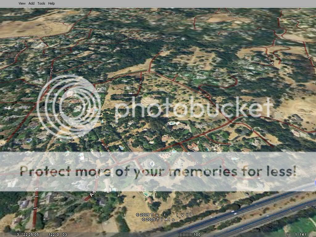
Here's a rendering of a popular climb in our area. - Page Mill.. The path I have highlighted is from the "Park 'n Go" at Arestadero/280, all the way up to 35..

Here's a rendering of a popular climb in our area. - Page Mill.. The path I have highlighted is from the "Park 'n Go" at Arestadero/280, all the way up to 35..
07-07-05, 11:29 PM
#17
Specialized Member

Join Date: Nov 2003
Location: I live in a small town
Posts: 973
Bikes: 2004 Specialized Allez
Mentioned: 0 Post(s)
Tagged: 0 Thread(s)
Quoted: 0 Post(s)
Likes: 0
Liked 0 Times
in
0 Posts
this thread needs to be combined with the google earth thread curently in the foo
__________________
You can never be too Specialized
Click here if any of the following apply to you:
1 You dont like Specialized, 2 You drive a SUV, 3 Your name is George Bush
You can never be too Specialized
Click here if any of the following apply to you:
1 You dont like Specialized, 2 You drive a SUV, 3 Your name is George Bush
07-07-05, 11:33 PM
#18
semifreddo amartuerer
Join Date: Oct 2004
Location: Northern CA
Posts: 4,599
Bikes: several
Mentioned: 0 Post(s)
Tagged: 0 Thread(s)
Quoted: 1 Post(s)
Likes: 0
Liked 2 Times
in
2 Posts
Originally Posted by cryogenic
total elevation change on that route?
07-07-05, 11:34 PM
#19
Specialized Member
Join Date: Nov 2003
Location: I live in a small town
Posts: 973
Bikes: 2004 Specialized Allez
Mentioned: 0 Post(s)
Tagged: 0 Thread(s)
Quoted: 0 Post(s)
Likes: 0
Liked 0 Times
in
0 Posts
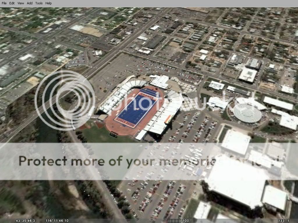
and yes this thing is freaking amazing, not only with its 3d abilities but with the detail of the close up images.
check out this awsome pic of Bronco stadium.
check out this awsome pic of Bronco stadium.
__________________
You can never be too Specialized
Click here if any of the following apply to you:
1 You dont like Specialized, 2 You drive a SUV, 3 Your name is George Bush
You can never be too Specialized
Click here if any of the following apply to you:
1 You dont like Specialized, 2 You drive a SUV, 3 Your name is George Bush
07-07-05, 11:44 PM
#20
�ber member!
Thread Starter
Join Date: Sep 2001
Location: Sunnyvale, CA.
Posts: 993
Bikes: 2004 Albert Eisentraut
Mentioned: 0 Post(s)
Tagged: 0 Thread(s)
Quoted: 0 Post(s)
Likes: 0
Liked 0 Times
in
0 Posts
Originally Posted by cryogenic
total elevation change on that route?
thats the climb profile.
07-08-05, 12:04 AM
#21
Campy or bust :p
Join Date: Oct 2004
Location: Knoxville, TN
Posts: 3,139
Bikes: Surly Karate Monkey commuter build
Mentioned: 0 Post(s)
Tagged: 0 Thread(s)
Quoted: 0 Post(s)
Likes: 0
Liked 0 Times
in
0 Posts
yipes... 2000ft of climbing over 8.25 miles. I'd die
07-08-05, 12:06 AM
#22
Specialized Member
Join Date: Nov 2003
Location: I live in a small town
Posts: 973
Bikes: 2004 Specialized Allez
Mentioned: 0 Post(s)
Tagged: 0 Thread(s)
Quoted: 0 Post(s)
Likes: 0
Liked 0 Times
in
0 Posts
Originally Posted by sorebutt
Man! this thing is addictive!!
Here's a rendering of a popular climb in our area. - Page Mill.. The path I have highlighted is from the "Park 'n Go" at Arestadero/280, all the way up to 35..
Here's a rendering of a popular climb in our area. - Page Mill.. The path I have highlighted is from the "Park 'n Go" at Arestadero/280, all the way up to 35..
umm does anyone see something wrong here, my screen shot is of the exact same place as sorebutts screen shot...............i dont have emensely awsome 3d graphics.
__________________
You can never be too Specialized
Click here if any of the following apply to you:
1 You dont like Specialized, 2 You drive a SUV, 3 Your name is George Bush
You can never be too Specialized
Click here if any of the following apply to you:
1 You dont like Specialized, 2 You drive a SUV, 3 Your name is George Bush
07-08-05, 12:42 AM
#23
Campy or bust :p
Join Date: Oct 2004
Location: Knoxville, TN
Posts: 3,139
Bikes: Surly Karate Monkey commuter build
Mentioned: 0 Post(s)
Tagged: 0 Thread(s)
Quoted: 0 Post(s)
Likes: 0
Liked 0 Times
in
0 Posts
totally weird... could it be point of view of the camera? like tilt it down a bit? Or perhaps different graphics cards? Who knows?
07-08-05, 12:48 AM
#24
Elitist Jackass

Join Date: Oct 2003
Location: Georgia
Posts: 3,262
Bikes: Cannondale 2.8, Specialized S-works E5 road, GT Talera
Mentioned: 0 Post(s)
Tagged: 0 Thread(s)
Quoted: 0 Post(s)
Likes: 0
Liked 0 Times
in
0 Posts
go to tools, then options, then set the elevation exageration to 3
07-08-05, 01:28 AM
#25
Elitist Jackass
Join Date: Oct 2003
Location: Georgia
Posts: 3,262
Bikes: Cannondale 2.8, Specialized S-works E5 road, GT Talera
Mentioned: 0 Post(s)
Tagged: 0 Thread(s)
Quoted: 0 Post(s)
Likes: 0
Liked 0 Times
in
0 Posts
the nuclear test site near area 51 is cool, craters as big as small towns.. Its wild.