


Why I don't trust route choices from Ride With GPS
 07-26-23, 01:17 PM
#26
bicycle tourist
Thread Starter
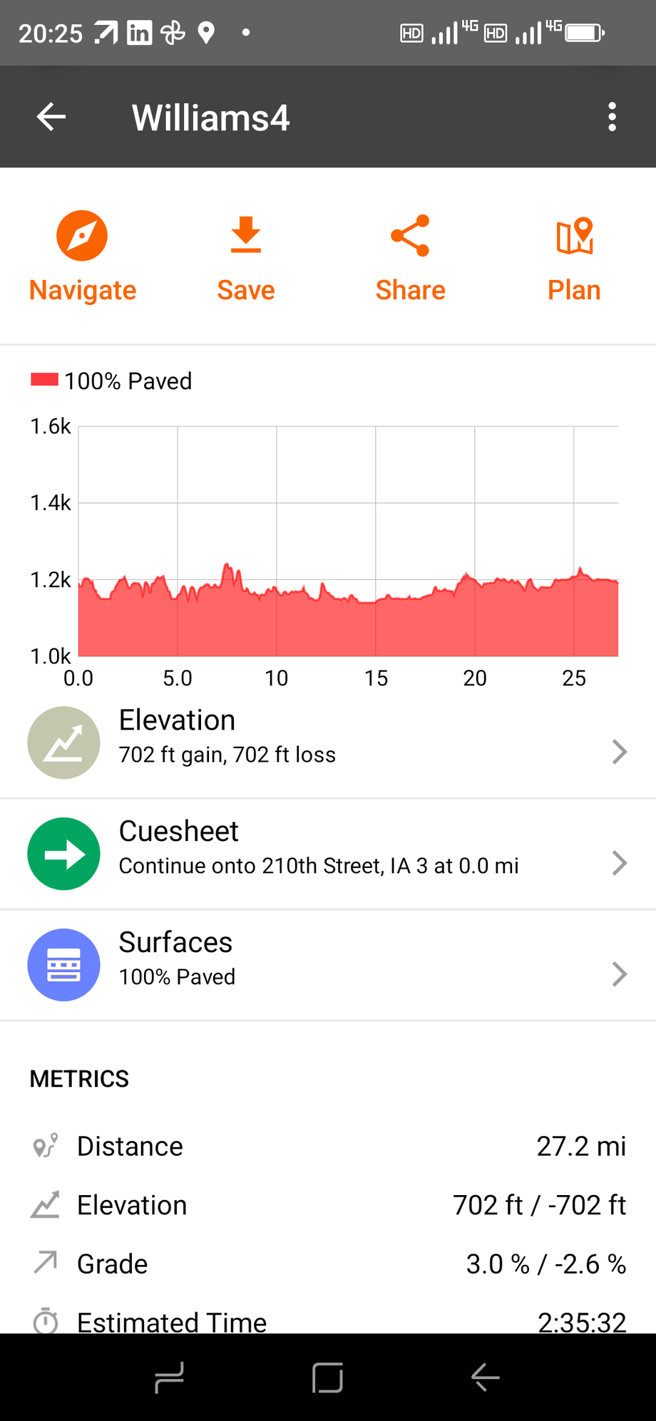
As I've gone through Indiana, Illinois, Minnesota and Iowa and presumably as I got further west states -until the west coast - there is a numbered federal and state highway system, almost all paved but the vast majority of county roads have not been paved (and don't really have Strava traffic). In this case, I can find two different defaults:
-- Komoot seems to assume unknown roads are not paved (or at least doesn't route me on them when I ask for road cycling); the error condition is you might end up on a slightly busier state route when a quieter paved route was available.
- RideWithGPS seems to assume unknown roads are paved, the error condition is you end up on gravel roads when RideWithGPS doesn't distinguish between this route is paved because I know it is - and this route is paved because I know nothing about it
So I would disagree that "the only sensible thing" for much of the area of the US is to assume unknown = paved.
However, that was more of a side note to general situation that RideWithGPS coincidentally was picking multiple choices where roads were closed that prompted the original post.
 07-26-23, 02:25 PM
#27
Senior Member
Join Date: Sep 2007
Location: Far beyond the pale horizon.
Posts: 14,350
Mentioned: 32 Post(s)
Tagged: 0 Thread(s)
Quoted: 4309 Post(s)
Liked 1,385 Times
in
965 Posts
(I've been in many places outside of NJ.)
I checked out random roads in IN (for example) and it doesn't appear the "vast majority" are unpaved. There are certainly many more unpaved roads in more rural states. Note that chipseal roads are "paved".
Of course, as you must know, these unpaved roads are fairly normal in those rural places. They aren't roads that "locals" avoid. If they did, they wouldn't get where they need to go.
If you are traveling in these sorts of places and are concerned with unpaved roads, you aren't going to have a happy time.
"Unpaved" is not that useful a designation since that includes roads that would be fine to drive/ride on and roads that would be much less so.
Anyway, Komoot doesn't appear to make that assumption.
Near 39.8016594,-86.4666371 is "East County Road 300 North". This road doesn't have surface type indicated in OSM. (It looks like it might be chipseal on Google Streetview.)
Komoot is treating this road as paved.
Were you using Google or OSM data in RWGPS (you don't say)? The data in rural places (where there is very little traffic) is not going to be as reliable.
Road closures are more of a concern (much more than unpaved roads in places where they are regular/common).
Last edited by njkayaker; 07-26-23 at 03:36 PM.
 07-26-23, 03:08 PM
#28
Senior Member
Join Date: Sep 2007
Location: Far beyond the pale horizon.
Posts: 14,350
Mentioned: 32 Post(s)
Tagged: 0 Thread(s)
Quoted: 4309 Post(s)
Liked 1,385 Times
in
965 Posts
https://www.google.com/maps/@0.16265...er=0&entry=ttu
OSM has no surface type data for the road but it's a "minor/unclassified road", which might not be unreasonable to assume is unpaved (in Kenya).
I created a route that was mostly on the unpaved road with a little bit on the main road.
Komoot is treating that road as paved. Interestingly, it's indicating that the paved road is "asphalt".
===============================
In another place with "carriage paths", these are indicated as "tracks" in OSM but don't have a surface designation. Komoot classifies the surface as "unknown".
Last edited by njkayaker; 07-26-23 at 03:22 PM.
07-26-23, 05:50 PM
#29
bicycle tourist
Thread Starter
I checked out random roads in IN (for example) and it doesn't appear the "vast majority" are unpaved. There are certainly many more unpaved roads in more rural states. Note that chipseal roads are "paved".
Of course, as you must know, these unpaved roads are fairly normal in those rural places. They aren't roads that "locals" avoid. If they did, they wouldn't get where they need to go.
If you are traveling in these sorts of places and are concerned with unpaved roads, you aren't going to have a happy time.
"Unpaved" is not that useful a designation since that includes roads that would be fine to drive/ride on and roads that would be much less so.
Road closures are more of a concern (much more than unpaved roads in places where they are regular/common).
When living in CO I started (by didn't finish before moving) an exercise to ride every road in the Weld County road network. At the time I recall ~20% paved and checking the web site now - https://www.weld.gov/Government/Depa...ce/Paved-Roads it is ~25%. In that case, I got what I expected and riding those areas set my expectations for how much pavement on the Great plains.
I'll also note that on average, Weld County was treating the unpaved routes in a way that made them relatively smooth and not a lot of (a) loose gravel (b) washboard/rutted or (c) surfaces that becomes soft/peanut butter after rains. So we're in agreement that surface conditions can vary widely on unpaved routes.
Also in agreement that closures are a bigger issue. I've been traveling overland between different state capitols and experimenting. Prior to using RWGPS, what I did in western less populated states was more often using a map and picking more of the state highway network or federal highways, perhaps augmented with a state bicycle map that gave info on shoulders and traffic volumes. That generally meant a lot fewer county roads, slightly more traffic and relatively direct routes. That wouldn't makes as much sense in populated area such as north east Ohio, but likely makes more sense in less populated area like south Dakota. I'll use RWGPS less in these areas.
07-26-23, 06:32 PM
#30
Senior Member
Join Date: Sep 2007
Location: Far beyond the pale horizon.
Posts: 14,350
Mentioned: 32 Post(s)
Tagged: 0 Thread(s)
Quoted: 4309 Post(s)
Liked 1,385 Times
in
965 Posts
RWGPS isn’t an originator of data (they can only use what they can get). Komoot doesn’t appear to have better surface data and it’s making the assumptions I expected.
It’s not reasonable to expect this data from RWGPS (or Komoot). So, yours is a case of using the wrong tool and not exactly correctly.
OSM data seems to be better in some European countries (Netherlands and Germany). So, it’s possible the surface data is better there.
One can get around some of the limitations by using satellite view (which it appears you didn't really do). Street view is better but it’s less available.
Last edited by njkayaker; 07-26-23 at 06:46 PM.
07-26-23, 07:29 PM
#31
bicycle tourist
Thread Starter
If it is a user error or incorrect tool to note information presented to be isn't correct - why does the tool present it in the first place?
For example if the tool either:
1. Presented no surface information similar to Google Maps or
2. Presented what it knows, e.g. 60% paved, 40% unknown
I would have no quibbles.
Last edited by mev; 07-26-23 at 07:43 PM.
07-26-23, 07:59 PM
#32
Senior Member
Join Date: Sep 2007
Location: Far beyond the pale horizon.
Posts: 14,350
Mentioned: 32 Post(s)
Tagged: 0 Thread(s)
Quoted: 4309 Post(s)
Liked 1,385 Times
in
965 Posts
- It might be (more) useful in some places.
- It might be that providing it (even if it’s not perfect) might make it more useful sooner.
- Map data is never “correct”. There are always going to be issues.
- If a GPS device tells you to drive off a bridge, would you do it?
Note that you knew that “most” of the roads in these places were unpaved yet you believed the “100% paved” (you “drove off the bridge”). Looking at Komoot shows that it isn’t any better. It’s using the same data (there is no other reasonably available data).
You didn’t use the satellite view. Even with RWGPS making it convenient. This (and other stuff) is what I did when planning trips in Europe for groups of people.
Note that one should use whatever one thinks works best. I just happen to understand why RWGPS has limitations on how you were trying to use it.
========================
Here is part of what RWGPS says about the feature:
https://ridewithgps.com/news/4930-in...-surface-types
Because you know your local roads best...
Like many other services out there, Ride with GPS relies on surface type data from OpenStreetMap (OSM), an open-source mapping service of the entire world. But we recognize that this data is incomplete, and our users riding those roads day in, day out know best. Therefore, we’re the first route planning service to allow users to visually adjust the surface types of their personal routes using the Ride with GPS Route Planner. For permanent changes, we encourage users to contribute up-to-date surface types information to OSM as well. Learn how.
Like many other services out there, Ride with GPS relies on surface type data from OpenStreetMap (OSM), an open-source mapping service of the entire world. But we recognize that this data is incomplete, and our users riding those roads day in, day out know best. Therefore, we’re the first route planning service to allow users to visually adjust the surface types of their personal routes using the Ride with GPS Route Planner. For permanent changes, we encourage users to contribute up-to-date surface types information to OSM as well. Learn how.
But providing a way to use the information might encourage people to update the information (an activity that would have been kind of pointless otherwise).
Last edited by njkayaker; 07-26-23 at 08:24 PM.
07-26-23, 09:18 PM
#33
Punk Rock Lives
Join Date: Feb 2002
Location: Throughout the west in a van, on my bike, and in the forest
Posts: 3,307
Bikes: Long Haul Trucker with BRIFTERS!
Mentioned: 0 Post(s)
Tagged: 0 Thread(s)
Quoted: 120 Post(s)
Liked 47 Times
in
41 Posts
My best tour guide�.
listen to the locals. They know about construction, repaving, quiet side roads and on and on. I only use maps for �macro� route planning and leave the rest to advice over coffee each morning, and sarandipity.
07-26-23, 10:22 PM
#34
Senior Member
Join Date: Mar 2010
Posts: 1,696
Mentioned: 7 Post(s)
Tagged: 0 Thread(s)
Quoted: 1262 Post(s)
Liked 1,363 Times
in
694 Posts
Theoretically sounds like a romantic way to travel however in the real world this approach would be an absolute disaster 95% of the time.
Likes For Atlas Shrugged:
07-27-23, 04:19 AM
#35
bicycle tourist
Thread Starter
My experience in asking locals is they don't always have a good sense of distance or preferences on roads for cycling. Even bridge closure information can be spotty, if you can't get through in a car, e.g. can I cross that bridge on a bike.
So I do like to ask and weigh it as a source of information, particularly on new changes like construction or paving. I am more suspect in asking questions like "how far to" or "best road to ride"
07-27-23, 05:04 AM
#36
Senior Member
My experience has been that the average local can be less relaible than google maps a lot of the time. I have gotten some terrible route advice. You really need to factor in how much you trust the individuls judgement.
I have found that truckers and farmers are particularly good at providing good trustworthy road info. For example a car driver might say "it is exactly 12 miles and flat the whole way". A trucker might say "don't hold me to this but it is about 21.5 miles. It starts out flat, but there is a 2 mile climb about 5 miles before you get there. It is a pretty good grade." If asked he might add "There is a shoulder the whole way, but it is gravel for a mile or so at the end". Guess which one was spot on? Hint it wasn't the car driver. They tend to give bad directions often grossly understating mileage and misstating road conditions.
Sometimes the direction giving is downright funny. In one case a lady told me I couldn't get to the airport on a bike. I tried to press her for directions, but she seemed sure it wasn't possible. I asked why it wasn't possible, was the road a freeway that didn't allow bikes? She said, no, it was just too far! Bear in mind that it was just a short hop, maybe 10 miles or so. I was loaded with gear so I thought it should have been obvious I was on the road. I explained that I had just ridden from a city that was maybe 1000 miles away. She finally relented and gave me directions.
07-27-23, 05:57 AM
#37
Senior Member
Join Date: Feb 2016
Location: SE Wisconsin
Posts: 1,855
Bikes: Lemond '01 Maillot Jaune, Lemond '02 Victoire, Lemond '03 Poprad, Lemond '03 Wayzata DB conv(Poprad), '79 AcerMex Windsor Carrera Professional(pur new), '88 GT Tequesta(pur new), '01 Bianchi Grizzly, 1993 Trek 970 DB conv, Trek 8900 DB conv
Mentioned: 12 Post(s)
Tagged: 0 Thread(s)
Quoted: 759 Post(s)
Likes: 0
Liked 811 Times
in
471 Posts
07-27-23, 07:36 AM
#38
Senior Member
Join Date: Jan 2010
Posts: 39,483
Mentioned: 211 Post(s)
Tagged: 1 Thread(s)
Quoted: 18517 Post(s)
Liked 15,844 Times
in
7,442 Posts
I learned that the third day of my first tour. Our Bozo tour leader messed up the grocery situation. A few of us volunteered to ride from camp to shop. Based on our ACA map, the nearest grocery store, which was off route, so mileage was not shown, appeared to be 8 miles each way. A campground ranger swore upo and down that it was only 8 miles round trip. Guess who was wrong and who was right.
07-27-23, 08:48 AM
#39
Senior Member
Join Date: Sep 2007
Location: Far beyond the pale horizon.
Posts: 14,350
Mentioned: 32 Post(s)
Tagged: 0 Thread(s)
Quoted: 4309 Post(s)
Liked 1,385 Times
in
965 Posts
This isn't as reliable or useful as you imagine. It also presumes you and the local speak the same language. Locals also often have no idea about bicycling. It's fine to ask but you should back it up with good map use.
Likes For njkayaker:
07-27-23, 12:15 PM
#40
Banned
I try to use routes input by individuals and not computer programs. The problem is inaccuracies with the two databases that all these applications use and when it comes to non-auto routes the databases should be expected to have holes.
When I started touring in the 1960's there were no bike maps and GPS did not exist. Bicyclists managed to find their way even if it was a trial and error approach. When I did my first trip the length of the California coast in 1970 with a friend we would encounter signs stating that bicycles were not allowed past that point. When we asked highway patrol guys where to go they would invariably say they had no idea but that if they saw us on the road they would give us a citation.
When my friend and I put together the first bike route map for the then California Division of Highways in 1973 it was with the understanding that their divsion offices would be responsible for updating the sections of the map in their territory to keep it up to date. When we had 10,000 copies of the map printed we caught hell from the highway engineers as they thought it was a 10 years supply. It turned out to be a 3 month supply.
I find ridewithgps to be the single best investment of my money in bicycling. I do check the routes as often their creators are less concerned with road traffic than I happen to be. I don't want to save 20 minutes of bicycling and end up under the wheels of some motorist's car because they were preoccupied with their smartphone or their hamburger or their cigarette or their vape device or their makeup.
07-27-23, 02:03 PM
#41
Senior Member
Join Date: Mar 2010
Posts: 1,696
Mentioned: 7 Post(s)
Tagged: 0 Thread(s)
Quoted: 1262 Post(s)
Liked 1,363 Times
in
694 Posts
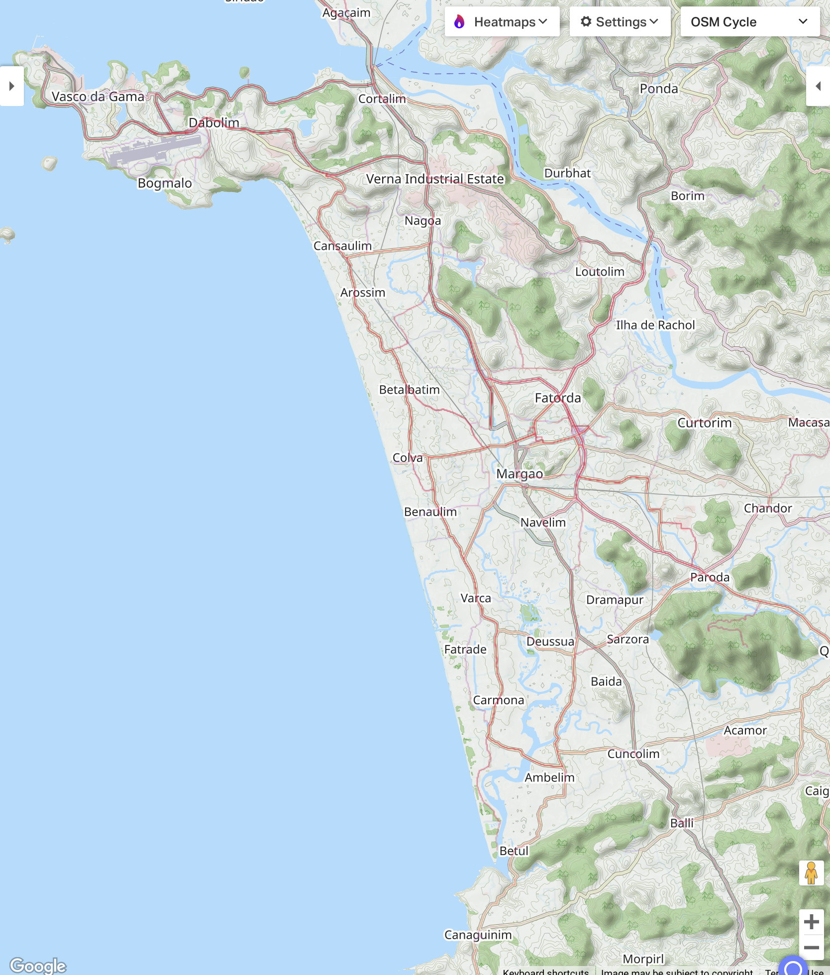
A interesting perspective is the newer heat mapping feature is very much like a selected sampling of locals advice regarding route selection. Effectively like asking local cyclists what roads do you use in a given location. Then combine that with street view or satellite view and it is by far the best way to travel in unknown places.
A vast majority of my touring involves locations where I don’t speak the native language. The idea that I am going to local coffee shop in Goa (the map above) and ask for route advice is not realistic. Same would apply even if I could speak the language am I really going to ask a local non cyclist in Bisbee Az. for the best route to Tucson, not a chance, I will be relying on technology.
Last edited by Atlas Shrugged; 07-27-23 at 07:10 PM.
07-27-23, 04:30 PM
#42
bicycle tourist
Thread Starter
The AI approach on classifying roads is an interesting exercise, though I expect the a difficulty can be getting enough labeled data to get the accuracy up.
