


How much accuracy do you demand from your bike computer?
 04-21-23, 04:45 PM
#26

don't try this at home.

Join Date: Jan 2006
Location: N. KY
Posts: 5,971
Mentioned: 10 Post(s)
Tagged: 0 Thread(s)
Quoted: 986 Post(s)
Liked 526 Times
in
361 Posts
Actual wheel size measurement:
When I used wheel magnet speed sensors, I did a rollout to get a pretty accurate wheel size:
Start with the valve stem at the bottom center. Put a tape marker on the floor -- sight over the handbar down to the valve stem for consistency. I liked to roll two full revolutions if I had room. Mark the ending point of the valve. Now measure the distance with a tape measure. Divide by two to get one revolution. google "inches to mm" and do the conversion to mm. That circumference of the wheel in mm is the usual number to put in.
You are supposed to press down with your weight on the bike, but it didn't seem to make a lot of difference.
~~~
GPS accuracy:
From a recent ride using my Garmin 1030. This map is from the useful "My Tourbook" PC software, that holds my rides history.
The dots are one-per-second recorded locations from the Garmin. They are color coded by speed. This was about 17 mph, on flat roads in farmland.
With heavy tree cover, roads with steep hillsides that reflect GPS transmissions, or downtown buildings, the path drifts more, and accuracy is less.
The map: Outbound from the east, with a left turn heading south. returning from the west to east. You can see which side of this two lane country road we were on! The scale on the map, 0.05 miles, is 264 feet.
(I was quite surprised the first time I saw these maps. It's amazing that the GPS can do that complicated math once a second and be this accurate.)

Wheel sensor with GPS
I have the Garmin sensor that straps around the hub and uses accelerometers to count wheel revolutions. It knows instantly when I'm stopped, and it's more accurate on low speed, steep climbs too.
The Garmin 1030 is set to "automatic wheel size", it recalcs wheel size from the GPS data as I ride. I think it's accurate, and it's simple too.
When I used wheel magnet speed sensors, I did a rollout to get a pretty accurate wheel size:
Start with the valve stem at the bottom center. Put a tape marker on the floor -- sight over the handbar down to the valve stem for consistency. I liked to roll two full revolutions if I had room. Mark the ending point of the valve. Now measure the distance with a tape measure. Divide by two to get one revolution. google "inches to mm" and do the conversion to mm. That circumference of the wheel in mm is the usual number to put in.
You are supposed to press down with your weight on the bike, but it didn't seem to make a lot of difference.
~~~
GPS accuracy:
From a recent ride using my Garmin 1030. This map is from the useful "My Tourbook" PC software, that holds my rides history.
The dots are one-per-second recorded locations from the Garmin. They are color coded by speed. This was about 17 mph, on flat roads in farmland.
With heavy tree cover, roads with steep hillsides that reflect GPS transmissions, or downtown buildings, the path drifts more, and accuracy is less.
The map: Outbound from the east, with a left turn heading south. returning from the west to east. You can see which side of this two lane country road we were on! The scale on the map, 0.05 miles, is 264 feet.
(I was quite surprised the first time I saw these maps. It's amazing that the GPS can do that complicated math once a second and be this accurate.)
Wheel sensor with GPS
I have the Garmin sensor that straps around the hub and uses accelerometers to count wheel revolutions. It knows instantly when I'm stopped, and it's more accurate on low speed, steep climbs too.
The Garmin 1030 is set to "automatic wheel size", it recalcs wheel size from the GPS data as I ride. I think it's accurate, and it's simple too.

Likes For rm -rf:
04-21-23, 04:47 PM
#27
Senior Member

Join Date: Feb 2008
Location: Peoria, IL
Posts: 4,495
Mentioned: 86 Post(s)
Tagged: 0 Thread(s)
Quoted: 1834 Post(s)
Liked 3,413 Times
in
1,591 Posts
Relying on the precision of a gang of long-dead cranky guys in the 1800s with a magnetic compass, optical transit, and metal surveyor's chain.
And an a lot of places, they were pretty darn close - sometimes only yards, feet, or inches off after setting a township line. In other cases, though...

Still, as a civil PE who doesn't have his RLS, I shouldn't give them too hard a time, considering the difficulties of cadastral surveying back in the day.
And an a lot of places, they were pretty darn close - sometimes only yards, feet, or inches off after setting a township line. In other cases, though...
Still, as a civil PE who doesn't have his RLS, I shouldn't give them too hard a time, considering the difficulties of cadastral surveying back in the day.
There are a number of those sorts of "jogs" in the roads around here too. The roads are all laid out in a 1 mile grid, except for where rivers and such interfere. I have a lot of respect for the folks out in the field with transits and the measuring chains, taking careful measurements and notes. Nothing is perfect, and the errors add up. Eventually things need to be tweaked a bit to compensate for the inevitable errors.
Such is life.
In regards to tracking one's location over long distances, I'm also impressed by folks who track the stars to know where they are. I'm amazed that aircraft are often equipped with windows to allow the navigator to take a fix on a few stars as a back-up to whatever their navigation system is (or was). Even spacecraft have been equipped with star trackers to know their orientation (and control it).
Steve in Peoria
 04-21-23, 04:54 PM
#28
don't try this at home.
Join Date: Jan 2006
Location: N. KY
Posts: 5,971
Mentioned: 10 Post(s)
Tagged: 0 Thread(s)
Quoted: 986 Post(s)
Liked 526 Times
in
361 Posts
Relying on the precision of a gang of long-dead cranky guys in the 1800s with a magnetic compass, optical transit, and metal surveyor's chain.
And an a lot of places, they were pretty darn close - sometimes only yards, feet, or inches off after setting a township line. In other cases, though...
Still, as a civil PE who doesn't have his RLS, I shouldn't give them too hard a time, considering the difficulties of cadastral surveying back in the day.
~~~
Canals!
I want to know how they surveyed canals in the 1820s with distance chains and simple transits. Obviously, the level is extremely critical, over long distances, so that water fills the canal and flows correctly.
Last edited by rm -rf; 04-21-23 at 04:59 PM.
Likes For rm -rf:
04-21-23, 05:33 PM
#29

Cantilever believer

Join Date: Nov 2021
Location: Phoenix, AZ
Posts: 1,623
Mentioned: 5 Post(s)
Tagged: 0 Thread(s)
Quoted: 554 Post(s)
Liked 1,920 Times
in
863 Posts
I can't tell if that's an error or one of the grid corrections needed for N-S square grids on a spherical earth. (It does look like they either miscalculated or detoured around something.)

There was a local news story recently about someone pronouncing the road's name similar to that of a petroleum jelly product. Beats reporting on actual news, I suppose.
__________________
Richard C. Moeur, PE - Phoenix AZ, USA
https://www.richardcmoeur.com/bikestuf.html
Richard C. Moeur, PE - Phoenix AZ, USA
https://www.richardcmoeur.com/bikestuf.html
Likes For RCMoeur:
04-21-23, 05:44 PM
#30
Senior Member
Join Date: Jul 2007
Location: South shore, L.I., NY
Posts: 6,955
Bikes: Flyxii FR322, Cannondale Topstone, Miyata City Liner, Specialized Chisel, Specialized Epic Evo
Mentioned: 18 Post(s)
Tagged: 0 Thread(s)
Quoted: 3298 Post(s)
Liked 2,130 Times
in
1,205 Posts
There are a lot of examples of surveys that once thought to be correct are later found out to not be. One of the more egregious is the so called "Four Corners" of the states of Colorado, Utah, New Mexico and Arizona. Where a nice tourist attraction exists that lets you place a hand leg in every one of those states. Unfortunately the actual corner boundary was found to be about 1800 feet to east. Nobody feels like moving the monument.
Likes For Steve B.:
04-21-23, 06:16 PM
#31
Cantilever believer
Join Date: Nov 2021
Location: Phoenix, AZ
Posts: 1,623
Mentioned: 5 Post(s)
Tagged: 0 Thread(s)
Quoted: 554 Post(s)
Liked 1,920 Times
in
863 Posts
There are a lot of examples of surveys that once thought to be correct are later found out to not be. One of the more egregious is the so called "Four Corners" of the states of Colorado, Utah, New Mexico and Arizona. Where a nice tourist attraction exists that lets you place a hand leg in every one of those states. Unfortunately the actual corner boundary was found to be about 1800 feet to east. Nobody feels like moving the monument.
Now if you want survey shenanigans, talk to New Mexico about how Texas carved off a slice of their eastern edge - and they're still riled up about it.
Likes For RCMoeur:
04-21-23, 06:41 PM
#32
Senior Member
Join Date: Nov 2005
Location: NW Ohio
Posts: 3,445
Bikes: 1984 Miyata 310, 1986 Schwinn Sierra, 2011 Jamis Quest, 1980 Peugeot TH8 Tandem, 1992 Performance Parabola, 1987 Ross Mt. Hood, 1988 Schwinn LeTour, 1988 Trek 400T, 1981 Fuji S12-S LTD, 197? FW Evans
Mentioned: 24 Post(s)
Tagged: 0 Thread(s)
Quoted: 541 Post(s)
Liked 1,037 Times
in
532 Posts
A long time ago, before GPS and cell phones, I ran SCCA road rallies. The rally would always start off with a few miles for an odometer check. The route instructions would tell you the start and stop and the official mileage so you could calculate a correction factor for your car. That number was used for the rest of the rally to adjust your speed and mileage calculations. It wouldn't be very hard to do something similar to get a correction factor for your bike computer. Just use a GPS or phone to measure a course of a few miles, preferably on a straight piece of road, then calculate a correction factor for the bike(s) in question.
04-21-23, 06:41 PM
#33
Passista
Join Date: Jul 2005
Posts: 7,638
Bikes: 1998 Pinarello Asolo, 1992 KHS Monta�a pro, 1980 Raleigh DL-1, IGH Hybrid, IGH Utility
Mentioned: 5 Post(s)
Tagged: 0 Thread(s)
Quoted: 883 Post(s)
Liked 737 Times
in
405 Posts
I compare my computer distance to distance measured on Google Earth and correct accordingly. Not sure about GE actual accuraccy though...
04-21-23, 07:02 PM
#34
Senior Member
Join Date: Jul 2007
Location: South shore, L.I., NY
Posts: 6,955
Bikes: Flyxii FR322, Cannondale Topstone, Miyata City Liner, Specialized Chisel, Specialized Epic Evo
Mentioned: 18 Post(s)
Tagged: 0 Thread(s)
Quoted: 3298 Post(s)
Liked 2,130 Times
in
1,205 Posts
As a resident of the state in the southwest quadrant, a slight correction: yes, the intent was to have the benchmark and monument at 37 degrees N and 32 degrees west of Washington DC. But the survey lines converging on the monument are the actual legal state boundaries, slight deviations and all.
Now if you want survey shenanigans, talk to New Mexico about how Texas carved off a slice of their eastern edge - and they're still riled up about it.
Now if you want survey shenanigans, talk to New Mexico about how Texas carved off a slice of their eastern edge - and they're still riled up about it.
04-21-23, 07:27 PM
#35
Bike Butcher of Portland

Join Date: Jul 2014
Location: Portland, OR
Posts: 11,660
Bikes: It's complicated.
Mentioned: 1302 Post(s)
Tagged: 0 Thread(s)
Quoted: 4694 Post(s)
Liked 5,846 Times
in
2,300 Posts
Andy_K and I measure our rides together by how many beers it takes to rehydrate afterwards. It's a good system.
__________________
If someone tells you that you have enough bicycles and you don't need any more, stop talking to them. You don't need that kind of negativity in your life.
If someone tells you that you have enough bicycles and you don't need any more, stop talking to them. You don't need that kind of negativity in your life.
Likes For gugie:
04-21-23, 07:36 PM
#36
Senior Member
Join Date: Feb 2008
Location: Peoria, IL
Posts: 4,495
Mentioned: 86 Post(s)
Tagged: 0 Thread(s)
Quoted: 1834 Post(s)
Liked 3,413 Times
in
1,591 Posts
You work with any young'uns? It would seem that schools don't teach signficant digits anymore! "The electronic display said 12.385", then you look at the accuracy of the sensor and it's +/-0.5%...
Andy_K and I measure our rides together by how many beers it takes to rehydrate afterwards. It's a good system.
Andy_K and I measure our rides together by how many beers it takes to rehydrate afterwards. It's a good system.
Granted, it's a bit esoteric/archaic now, and really doesn't affect most folks.
Still... I know folks that will ride around the parking lot after a bike ride, just to watch their computer/gps/garmin/etc. roll over to 50.00 miles, and I just sorta shake my head and sigh.
Steve in Peoria
Likes For steelbikeguy:
04-21-23, 08:34 PM
#37
It's MY mountain

Join Date: Sep 2006
Location: Mt.Diablo
Posts: 10,004
Bikes: Klein, Merckx, Trek
Mentioned: 70 Post(s)
Tagged: 0 Thread(s)
Quoted: 4352 Post(s)
Liked 3,014 Times
in
1,636 Posts
Likes For DiabloScott:
04-21-23, 09:13 PM
#38
Senior Member
Join Date: Nov 2005
Location: NW Ohio
Posts: 3,445
Bikes: 1984 Miyata 310, 1986 Schwinn Sierra, 2011 Jamis Quest, 1980 Peugeot TH8 Tandem, 1992 Performance Parabola, 1987 Ross Mt. Hood, 1988 Schwinn LeTour, 1988 Trek 400T, 1981 Fuji S12-S LTD, 197? FW Evans
Mentioned: 24 Post(s)
Tagged: 0 Thread(s)
Quoted: 541 Post(s)
Liked 1,037 Times
in
532 Posts
04-21-23, 09:29 PM
#39
Senior Member
Join Date: Apr 2011
Posts: 7,272
Mentioned: 43 Post(s)
Tagged: 0 Thread(s)
Quoted: 4539 Post(s)
Liked 1,676 Times
in
1,098 Posts
When I started having multiple road bikes I stopped buying computers. But then I got into a riding with que sheets, so I "replaced" my computer with the minute hand on my wristwatch: 3 miles = 9-10 minutes, depending on hills.
04-22-23, 12:00 AM
#40
Crawlin' up, flyin' down

Join Date: Jan 2006
Location: Democratic Peoples' Republic of Berkeley
Posts: 5,699
Bikes: 1967 Paramount; 1982-ish Ron Cooper; 1978 Eisentraut "A"; two mid-1960s Cinelli Speciale Corsas; and others in various stages of non-rideability.
Mentioned: 40 Post(s)
Tagged: 0 Thread(s)
Quoted: 1049 Post(s)
Liked 2,593 Times
in
1,082 Posts
There is an event custom made for you right here.
You're welcome.
You're welcome.
As an engineer, I learned to always carefully check for the accuracy of any measuring equipment that I use. There's also the rule of "significant digits"... never use more digits when taking a measurement than the measuring device actually is good for. If my Cateye is only good for 1% accuracy, it would be useless to say that my ride was 110.5 miles long... it could have been 109 or 111.
There is also the idea of "good enough" accuracy for a given task. More accuracy costs time and money, usually.
Besides... no one really cares how far you (or any one of us) rode.
I prefer to measure rides in the number of donuts enjoyed...

Steve in Peoria
There is also the idea of "good enough" accuracy for a given task. More accuracy costs time and money, usually.
Besides... no one really cares how far you (or any one of us) rode.
I prefer to measure rides in the number of donuts enjoyed...
Steve in Peoria
__________________
"I'm in shape -- round is a shape." Andy Rooney
"I'm in shape -- round is a shape." Andy Rooney
04-22-23, 08:02 AM
#41
Senior Member

Join Date: Aug 2015
Posts: 3,324
Mentioned: 39 Post(s)
Tagged: 0 Thread(s)
Quoted: 1149 Post(s)
Liked 1,774 Times
in
974 Posts
The Seattle area has a big survey mishap. It's known as the Renton 'S' Curves on the I-405. They were building the freeway from opposite directions and had to quickly re-engineer the freeway into the curve to compensate.
I myself don't use any bike computers or guidance aids.
I myself don't use any bike computers or guidance aids.
04-22-23, 08:27 AM
#42
aged to perfection

Join Date: Jun 2009
Location: PacNW
Posts: 1,852
Bikes: Dinucci Allez 2.0, Richard Sachs, Alex Singer, Serotta, Masi GC, Raleigh Pro Mk.1, Hetchins, etc
Mentioned: 24 Post(s)
Tagged: 0 Thread(s)
Quoted: 852 Post(s)
Liked 1,278 Times
in
674 Posts
this was a good discussion, altho it should probably be in the "lighting and electronics" section of BF. I especially liked "rm -rf"s track plot showing the 1 pps position fixes. that was new to me. Thanks.
Since the original question was "how accurate should your GPS bike navigator be" it's probably worth a discussion of the GPS satellite navigation system and how it works. This is a fascinating topic.
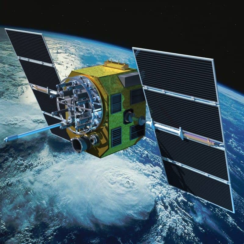
First off, there is NO position information coming down from the GPS satellites, of which there are 24 on orbit, plus some spares. this is an important point. Of the 24 satellites, you can see at best, 8 or 9, and your receiver will pick the 4 or 5 satellites with the best signal;. The Block IIF and Block IIIa satellites currently on orbit ONLY send a very accurate time signal, along with some spacecraft ephemeris (position) data. The satellites, which orbit at 12,600 miles above the earth, send their time signal on 4 (Block II) or 5 (Block III) frequencies in the range of 1.175 - 1.76 Ghz ranges. There are several levels of time signal (referred to as the TOT) embedded in different GPS signals, but the one that we civilians get to use is called the CA code, which stands for "coarse acquisition", and when processed by the receiver, the best possible accuracy to be obtained, assuming perfect signal reception and the best possible satellite arrangement (multilateration or PDOP) will give a position accuracy to about 4.9 meters or 15 feet. Of course there are additional GPS signals, some of which are encrypted for military use, that allow position accuracy considerably better than that :
Now it gets even more interesting because your little Wahoo or Garmin unit is doing some clever stuff with the received data. The 1pps position estimate is based on the receiver's ability to process all the time signals and derive an estimated position. The first thing it does is "snap" the position estimate to the receiver's street map data, allowing you to see what street you are on ! This would be very hard to do with satellite data alone ! The second thing it does is derive an estimated speed based on the distance between the most recent position fixes. Now you can see where you are, how fast you are going, and how far you have traveled.
Several posters above have noted that wheel sensors are more accurate indicators of speed and distance, and yes this is true, if correctly calibrated.
What is interesting is that the accuracy problem is shared between the satellite signal and the receiver's map and processing of the received signal. Your little Garmin or Wahoo unit puts a lot of navigation power on your bike for just a couple hundred bucks.
Some pics of the GPS satellite constellation and a Block II satellite are included below
if you want to learn more, the wikipedia page is very helpful. I wrote some of it. Global Positioning System - Wikipedia
/markp

Since the original question was "how accurate should your GPS bike navigator be" it's probably worth a discussion of the GPS satellite navigation system and how it works. This is a fascinating topic.
First off, there is NO position information coming down from the GPS satellites, of which there are 24 on orbit, plus some spares. this is an important point. Of the 24 satellites, you can see at best, 8 or 9, and your receiver will pick the 4 or 5 satellites with the best signal;. The Block IIF and Block IIIa satellites currently on orbit ONLY send a very accurate time signal, along with some spacecraft ephemeris (position) data. The satellites, which orbit at 12,600 miles above the earth, send their time signal on 4 (Block II) or 5 (Block III) frequencies in the range of 1.175 - 1.76 Ghz ranges. There are several levels of time signal (referred to as the TOT) embedded in different GPS signals, but the one that we civilians get to use is called the CA code, which stands for "coarse acquisition", and when processed by the receiver, the best possible accuracy to be obtained, assuming perfect signal reception and the best possible satellite arrangement (multilateration or PDOP) will give a position accuracy to about 4.9 meters or 15 feet. Of course there are additional GPS signals, some of which are encrypted for military use, that allow position accuracy considerably better than that :
Now it gets even more interesting because your little Wahoo or Garmin unit is doing some clever stuff with the received data. The 1pps position estimate is based on the receiver's ability to process all the time signals and derive an estimated position. The first thing it does is "snap" the position estimate to the receiver's street map data, allowing you to see what street you are on ! This would be very hard to do with satellite data alone ! The second thing it does is derive an estimated speed based on the distance between the most recent position fixes. Now you can see where you are, how fast you are going, and how far you have traveled.
Several posters above have noted that wheel sensors are more accurate indicators of speed and distance, and yes this is true, if correctly calibrated.
What is interesting is that the accuracy problem is shared between the satellite signal and the receiver's map and processing of the received signal. Your little Garmin or Wahoo unit puts a lot of navigation power on your bike for just a couple hundred bucks.
Some pics of the GPS satellite constellation and a Block II satellite are included below
if you want to learn more, the wikipedia page is very helpful. I wrote some of it. Global Positioning System - Wikipedia
/markp
Last edited by mpetry912; 04-22-23 at 08:48 AM.
Likes For mpetry912:
04-22-23, 10:37 AM
#43
The Wheezing Geezer

Join Date: Oct 2021
Location: Espa�ola, NM
Posts: 1,088
Bikes: 1976 Fredo Speciale, Rivendell Clem Smith Jr., Libertas mixte
Mentioned: 1 Post(s)
Tagged: 0 Thread(s)
Quoted: 422 Post(s)
Liked 969 Times
in
465 Posts
I have removed the computer and sensors from my bike. I did that decades ago when I realized I paid more attention to the screen than the scenery, more attention to the numbers than the nuances of my daily ride; caring more about the machine than the man.
Get rid of your computer.
Get rid of your computer.
04-22-23, 10:44 AM
#44
The Wheezing Geezer
Join Date: Oct 2021
Location: Espa�ola, NM
Posts: 1,088
Bikes: 1976 Fredo Speciale, Rivendell Clem Smith Jr., Libertas mixte
Mentioned: 1 Post(s)
Tagged: 0 Thread(s)
Quoted: 422 Post(s)
Liked 969 Times
in
465 Posts
A long time ago, before GPS and cell phones, I ran SCCA road rallies. The rally would always start off with a few miles for an odometer check. The route instructions would tell you the start and stop and the official mileage so you could calculate a correction factor for your car. That number was used for the rest of the rally to adjust your speed and mileage calculations. It wouldn't be very hard to do something similar to get a correction factor for your bike computer. Just use a GPS or phone to measure a course of a few miles, preferably on a straight piece of road, then calculate a correction factor for the bike(s) in question.
04-22-23, 10:49 AM
#45
Edumacator
Join Date: Jan 2018
Location: Goose Creek, SC
Posts: 6,984
Bikes: '87 Crestdale, '87 Basso Gap, '92 Rossin Performance EL-OS, 1990 VanTuyl, 1980s Losa, 1985 Trek 670, 1982 AD SLE, 1987 PX10, etc...
Mentioned: 59 Post(s)
Tagged: 0 Thread(s)
Quoted: 2502 Post(s)
Liked 3,259 Times
in
2,053 Posts
You work with any young'uns? It would seem that schools don't teach signficant digits anymore! "The electronic display said 12.385", then you look at the accuracy of the sensor and it's +/-0.5%...
Andy_K and I measure our rides together by how many beers it takes to rehydrate afterwards. It's a good system.
Andy_K and I measure our rides together by how many beers it takes to rehydrate afterwards. It's a good system.
__________________
1987 Crest Cannondale, 1987 Basso Gap, 1992 Rossin Performance EL, 1990ish Van Tuyl, 1985 Trek 670, 2003 Pinarello Surprise, 1990ish MBK Atlantique, 1987 Peugeot Competition, 1987 Nishiki Tri-A, 1981 Faggin, 1996 Cannondale M500, 1984 Mercian, 1982 AD SuperLeicht, 1985 Massi (model unknown), 1988 Daccordi Griffe , 1989 Fauxsin MTB, 1981 Ciocc Mockba, 1992 Bianchi Giro, 1977 Colnago Super, 1971 Raleigh International, 1998 Corratec Ap & Dun, 1991 Peugeot Slimestone
1987 Crest Cannondale, 1987 Basso Gap, 1992 Rossin Performance EL, 1990ish Van Tuyl, 1985 Trek 670, 2003 Pinarello Surprise, 1990ish MBK Atlantique, 1987 Peugeot Competition, 1987 Nishiki Tri-A, 1981 Faggin, 1996 Cannondale M500, 1984 Mercian, 1982 AD SuperLeicht, 1985 Massi (model unknown), 1988 Daccordi Griffe , 1989 Fauxsin MTB, 1981 Ciocc Mockba, 1992 Bianchi Giro, 1977 Colnago Super, 1971 Raleigh International, 1998 Corratec Ap & Dun, 1991 Peugeot Slimestone
04-22-23, 12:00 PM
#46
Bike Butcher of Portland
Join Date: Jul 2014
Location: Portland, OR
Posts: 11,660
Bikes: It's complicated.
Mentioned: 1302 Post(s)
Tagged: 0 Thread(s)
Quoted: 4694 Post(s)
Liked 5,846 Times
in
2,300 Posts
04-22-23, 12:53 PM
#47
Senior Member
Thread Starter
Join Date: Jan 2019
Location: Toledo Ohio
Posts: 1,505
Bikes: 1964 Huffy Sportsman, 1972 Fuji Newest, 1973 Schwinn Super Sport (3), 1982 Trek 412, 1983 Trek 700, 1989 Miyata 1000LT, 1991 Bianchi Boardwalk, plus others
Mentioned: 21 Post(s)
Tagged: 0 Thread(s)
Quoted: 584 Post(s)
Liked 704 Times
in
397 Posts
So has anyone ever checked the old mechanical cyclometers that mounted at the axle? I know Schwinn of course offered ones, and there are/were many others. It would be interesting to check with the modern devices we have now. I’m still sticking to my story of a 600 mile circle Ohio ride with 3 centuries as recorded by the Schwinn unit in about 1980.
04-22-23, 01:49 PM
#48
Senior Member
Join Date: Jul 2007
Location: South shore, L.I., NY
Posts: 6,955
Bikes: Flyxii FR322, Cannondale Topstone, Miyata City Liner, Specialized Chisel, Specialized Epic Evo
Mentioned: 18 Post(s)
Tagged: 0 Thread(s)
Quoted: 3298 Post(s)
Liked 2,130 Times
in
1,205 Posts
[QUOTE=mpetry912;22867731]
Since the original question was "how accurate should your GPS bike navigator be"
The original question made no mention of GPS. I think most of those replying assumed that was the target of the discussion.
Since the original question was "how accurate should your GPS bike navigator be"
The original question made no mention of GPS. I think most of those replying assumed that was the target of the discussion.
04-22-23, 02:06 PM
#49
aged to perfection
Join Date: Jun 2009
Location: PacNW
Posts: 1,852
Bikes: Dinucci Allez 2.0, Richard Sachs, Alex Singer, Serotta, Masi GC, Raleigh Pro Mk.1, Hetchins, etc
Mentioned: 24 Post(s)
Tagged: 0 Thread(s)
Quoted: 852 Post(s)
Liked 1,278 Times
in
674 Posts
you're right.
maybe I will delete my post !
/markp
maybe I will delete my post !
/markp
04-22-23, 04:34 PM
#50
Senior Member
Join Date: Sep 2020
Location: SE Wyoming
Posts: 604
Bikes: 1995 Specialized Rockhopper,1989 Specialized Rock Combo, 2013 Specialized Tarmac Elite
Mentioned: 0 Post(s)
Tagged: 0 Thread(s)
Quoted: 213 Post(s)
Liked 588 Times
in
278 Posts
All I want from my very basic Garmin during the ride is how fast and how far. My Apple watch delivers more datum to my iPhone - speed splits, heart rate, elevation changes, map, etc.