


Cycling over the Rocky Mountains
 02-22-19, 09:37 AM
#26
Palmer

Join Date: Mar 2007
Location: Parts Unknown
Posts: 8,629
Bikes: Mike Melton custom, Alex Moulton AM, Dahon Curl
Mentioned: 37 Post(s)
Tagged: 0 Thread(s)
Quoted: 1671 Post(s)
Liked 1,832 Times
in
1,064 Posts
There are plans to path Clear Creek Canyon (Hwy6) between Golden and I70, linking the Denver Airport with Loveland Pass by continuous paved path. The four miles completed so far in that canyon section are pretty incredible. Ah, someday.
Further west, the Colorado River Canyon gets so narrow...how narrow does it get?...that busy I70 doesn't even have full width shoulders in stretches. Not my idea of fun riding.
Further west, the Colorado River Canyon gets so narrow...how narrow does it get?...that busy I70 doesn't even have full width shoulders in stretches. Not my idea of fun riding.
Last edited by tcs; 02-22-19 at 09:51 AM.
 02-22-19, 09:37 AM
#27
Senior Member

Join Date: May 2008
Location: Zang's Spur, CO
Posts: 9,083
Mentioned: 11 Post(s)
Tagged: 0 Thread(s)
Quoted: 3379 Post(s)
Liked 5,541 Times
in
2,874 Posts
It's 107 miles, and I think I saw no more than 6 cars each time.
And of course whenever we saw one, we would be waving to each other.

 02-22-19, 09:41 AM
#28
Senior Member

Join Date: Apr 2011
Posts: 782
Mentioned: 1 Post(s)
Tagged: 0 Thread(s)
Quoted: 226 Post(s)
Liked 45 Times
in
32 Posts
I have been in touch with Nevada DOT to provide water for cyclists at DOT shops.
These are scattered across Nevada in very remote locations. Ideal for cyclists.
I have gotten all kinds of legalistic reasons why this cannot be done - -
but I am persisting and believe that some accommodations may soon be available.
Pic - Stone Cabin Valley on US 6
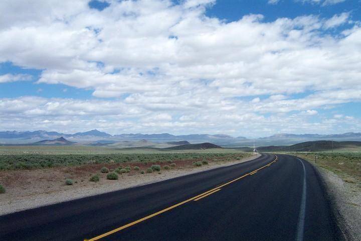
When I took the Hwy 50 alt-bypass between Middlegate and Austin (called hwy 2? now) it was half gravel in 1991. Glad I had a water filter. No cars seen all day. Great camping over some moderate mountain. If you like loneliness this is it.
02-22-19, 09:57 AM
#29
Senior Member
Join Date: Feb 2012
Location: Golden, CO and Tucson, AZ
Posts: 2,840
Bikes: 2012 Specialized Elite Disc, 1983 Trek 520
Mentioned: 13 Post(s)
Tagged: 0 Thread(s)
Quoted: 677 Post(s)
Liked 743 Times
in
432 Posts
When that path is finished, it'll cut 1000' of climbing out of the trip to the Divide, going both ways. So many times I've cussed Floyd Hill on the way home. (Who was that guy, anyway?) When I'm 80, I'll probably need that shortcut.
02-22-19, 12:21 PM
#30

staring at the mountains

Join Date: Mar 2005
Location: Castle Pines, CO
Posts: 4,560
Bikes: Obed GVR, Fairdale Goodship, Salsa Timberjack 29
Mentioned: 6 Post(s)
Tagged: 0 Thread(s)
Quoted: 394 Post(s)
Liked 197 Times
in
112 Posts
Oh and a note on Hwy 40 going west from Craig. There's nothing between Craig and Dinosaur. Google shows some town names, but there ain't nuthin there. That's either good or bad, depending on your outlook.
Last edited by superdex; 02-22-19 at 12:25 PM.
02-22-19, 04:50 PM
#31

Mad bike riding scientist

Join Date: Nov 2004
Location: Denver, CO
Posts: 27,378
Bikes: Some silver ones, a red one, a black and orange one, and a few titanium ones
Mentioned: 152 Post(s)
Tagged: 1 Thread(s)
Quoted: 6225 Post(s)
Liked 4,228 Times
in
2,372 Posts
While I may be mistaken, I believe you'll have to find an alternate route for the first leg out of Denver. I-70 goes through the Eisenhower tunnel for about 12 miles, and you have a choice of going north through Granby, south through Colorado Springs, or over some gravel passes.
FWIW, the Adventure Cycling Trans America route goes through Canon City and turns north, running under I-70 around Silverthorne.
FWIW, the Adventure Cycling Trans America route goes through Canon City and turns north, running under I-70 around Silverthorne.
Looks as though you are new around here.
Unless you have a really big reason to cycle through Denver,
You should consider crossing the Rockies west of Fort Collins. (60 miles north of Denver)
East to west - - Use Colorado Hwy 14 to Walden, then US 40 to Utah.
This is a much safer route with less traffic and ample services.
Hwy 14 thru the Poudre Canyon is stunning.
You can bike on a canal service road deep into the wilderness at Cameron Pass if you wish.
Walden is on the TransAm with bike friendly camping at the park.
Steamboat is a upscale ski/summer town that is hip & pricey.
Gets pretty darn empty west of Craig.
Highly suggest jaunt from Jensen, Utah into Dinosaur National Monument - fabulous sheer wall scenery.
__________________
Stuart Black
Plan Epsilon Around Lake Michigan in the era of Covid
Old School�When It Wasn�t Ancient bikepacking
Gold Fever Three days of dirt in Colorado
Pokin' around the Poconos A cold ride around Lake Erie
Dinosaurs in Colorado A mountain bike guide to the Purgatory Canyon dinosaur trackway
Solo Without Pie. The search for pie in the Midwest.
Picking the Scablands. Washington and Oregon, 2005. Pie and spiders on the Columbia River!
02-22-19, 10:20 PM
#32
Palmer
Join Date: Mar 2007
Location: Parts Unknown
Posts: 8,629
Bikes: Mike Melton custom, Alex Moulton AM, Dahon Curl
Mentioned: 37 Post(s)
Tagged: 0 Thread(s)
Quoted: 1671 Post(s)
Liked 1,832 Times
in
1,064 Posts
Maybe one could packraft for that stretch.

Last edited by tcs; 02-23-19 at 08:07 AM.
02-22-19, 10:34 PM
#33
Hooked on Touring
Denver has a metro population of 3 million; OK trails from Brighton, but tough from Bennett.
Highway 14 in the Poudre Canyon has a 1200 daily traffic count; 640 near Cameron Pass.
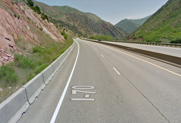
I-70 west of Glenwood - where you have to ride on the interstate - has a count of 26,000.
02-23-19, 09:50 AM
#34
Mad bike riding scientist
Join Date: Nov 2004
Location: Denver, CO
Posts: 27,378
Bikes: Some silver ones, a red one, a black and orange one, and a few titanium ones
Mentioned: 152 Post(s)
Tagged: 1 Thread(s)
Quoted: 6225 Post(s)
Liked 4,228 Times
in
2,372 Posts
Fort Collins has a metro population of 200,000 with a paved bike trail from east to west.
Denver has a metro population of 3 million; OK trails from Brighton, but tough from Bennett.
Highway 14 in the Poudre Canyon has a 1200 daily traffic count; 640 near Cameron Pass.
I-70 west of Glenwood - where you have to ride on the interstate - has a count of 26,000.
Denver has a metro population of 3 million; OK trails from Brighton, but tough from Bennett.
Highway 14 in the Poudre Canyon has a 1200 daily traffic count; 640 near Cameron Pass.
I-70 west of Glenwood - where you have to ride on the interstate - has a count of 26,000.
The highway counts you quote are misleading as well. Highway 14 is a narrow canyon road where riders are sharing the road with all 1200 of those drivers on a shoulderless road. I-70 may have 26,000 motorists on it but there is also an 11 foot shoulder that they don�t drive on. It�s not like you are riding in the traffic lane.
There is also the advantage of having far more services along the 1-70 corridor than from Fort Collins.
I�ve ridden a number of Interstates across the nation and, while they are a bit noisy, they are at least as safe as riding a narrow canyon road...perhaps safer.
__________________
Stuart Black
Plan Epsilon Around Lake Michigan in the era of Covid
Old School�When It Wasn�t Ancient bikepacking
Gold Fever Three days of dirt in Colorado
Pokin' around the Poconos A cold ride around Lake Erie
Dinosaurs in Colorado A mountain bike guide to the Purgatory Canyon dinosaur trackway
Solo Without Pie. The search for pie in the Midwest.
Picking the Scablands. Washington and Oregon, 2005. Pie and spiders on the Columbia River!
Stuart Black
Plan Epsilon Around Lake Michigan in the era of Covid
Old School�When It Wasn�t Ancient bikepacking
Gold Fever Three days of dirt in Colorado
Pokin' around the Poconos A cold ride around Lake Erie
Dinosaurs in Colorado A mountain bike guide to the Purgatory Canyon dinosaur trackway
Solo Without Pie. The search for pie in the Midwest.
Picking the Scablands. Washington and Oregon, 2005. Pie and spiders on the Columbia River!
02-23-19, 10:07 AM
#35
Mad bike riding scientist
Join Date: Nov 2004
Location: Denver, CO
Posts: 27,378
Bikes: Some silver ones, a red one, a black and orange one, and a few titanium ones
Mentioned: 152 Post(s)
Tagged: 1 Thread(s)
Quoted: 6225 Post(s)
Liked 4,228 Times
in
2,372 Posts
I would probably divert north from Dillion to Steamboat and points north on the TransAm.
__________________
Stuart Black
Plan Epsilon Around Lake Michigan in the era of Covid
Old School�When It Wasn�t Ancient bikepacking
Gold Fever Three days of dirt in Colorado
Pokin' around the Poconos A cold ride around Lake Erie
Dinosaurs in Colorado A mountain bike guide to the Purgatory Canyon dinosaur trackway
Solo Without Pie. The search for pie in the Midwest.
Picking the Scablands. Washington and Oregon, 2005. Pie and spiders on the Columbia River!
Stuart Black
Plan Epsilon Around Lake Michigan in the era of Covid
Old School�When It Wasn�t Ancient bikepacking
Gold Fever Three days of dirt in Colorado
Pokin' around the Poconos A cold ride around Lake Erie
Dinosaurs in Colorado A mountain bike guide to the Purgatory Canyon dinosaur trackway
Solo Without Pie. The search for pie in the Midwest.
Picking the Scablands. Washington and Oregon, 2005. Pie and spiders on the Columbia River!
02-23-19, 11:16 AM
#36
Hooked on Touring
CC -
I agree with you that riding on the interstate shoulders is pretty safe.
(Although with the growth in texting I am increasingly careful - even on the shoulder.)
Also, one needs to vigilant when riding shoulderless rural highways.
But the experience is profoundly different.
Not to mention that I think we have very different riding/touring styles.
You prefer services and higher quality roads; I prefer empty and am o.k. with a granola bar.
Most folks probably fall somewhere between Denver and Walden.
But that is precisely the issue - people who LIVE in Denver know the routes.
People who don't will often times spend extra hours figuring out how to get thru.
Although I live in Wyoming, I have thousands of miles of riding in Colorado.
I've ridden both Denver and Fort Collins - I find Fort Collins far more manageable.
I've ridden large sections of the I-70 corridor, as well as Highway 14.
I hear you when you say there's a shoulder on I-70 - but not always.
And those "not always" sections are pretty darn scary.
Esp. with traffic zooming by at 75 mph.
Even in western states that permit riding bikes on interstates,
I have found that shoulders sometimes disappear - especially on bridges & overpasses.
For an inexperienced touring cyclist it can be pretty terrifying getting out into a traffic lane.
Not to mention when they are doing road work and combine traffic on one side.
I do not absolutely exclude interstates, but I avoid them if at all possible.
Let me take a moment to offer drawbacks for Highway 14, as well.
It tends to be a weekend outing road for Fort Collins - so weekends can be tough, plus add alcohol.
You are right, it has minimal shoulders - sometimes 2 or 3 feet, sometimes 6 inches. (12 ft. travel lanes)
But on weekdays it may have only 600 vehicles per day - that's practically empty.
You may have ridden it only on weekends when the traffic is triple or more.
When I used to be in grad school in Laramie, we would drive down to Poudre Canyon in April.
To enjoy spring in Colorado which arrives 7 years before it gets to Wyoming.
(Shhh! Don't tell anyone that grad students bike on weekdays on nice spring days.)
Perhaps sunshine, 60-degree weather, and the canyon's beauty affected my thinking.
02-23-19, 11:54 AM
#37
staring at the mountains
Join Date: Mar 2005
Location: Castle Pines, CO
Posts: 4,560
Bikes: Obed GVR, Fairdale Goodship, Salsa Timberjack 29
Mentioned: 6 Post(s)
Tagged: 0 Thread(s)
Quoted: 394 Post(s)
Liked 197 Times
in
112 Posts
if I were doing it, I'd also divert north from I70 in Dillon on Hwy 9 (though the stretch from Kremmling to Steamboat has no cell service) -- Rabbit Ears Pass is beautiful. Then go through Craig and to Dinosaur. From there, west into that part of Utah is gorgeous and you easily wind up in Heber Valley and the SLC.
02-23-19, 01:44 PM
#38
Palmer
Join Date: Mar 2007
Location: Parts Unknown
Posts: 8,629
Bikes: Mike Melton custom, Alex Moulton AM, Dahon Curl
Mentioned: 37 Post(s)
Tagged: 0 Thread(s)
Quoted: 1671 Post(s)
Liked 1,832 Times
in
1,064 Posts
02-23-19, 07:52 PM
#39
Mad bike riding scientist
Join Date: Nov 2004
Location: Denver, CO
Posts: 27,378
Bikes: Some silver ones, a red one, a black and orange one, and a few titanium ones
Mentioned: 152 Post(s)
Tagged: 1 Thread(s)
Quoted: 6225 Post(s)
Liked 4,228 Times
in
2,372 Posts
CC -
I agree with you that riding on the interstate shoulders is pretty safe.
(Although with the growth in texting I am increasingly careful - even on the shoulder.)
Also, one needs to vigilant when riding shoulderless rural highways.
But the experience is profoundly different.
I agree with you that riding on the interstate shoulders is pretty safe.
(Although with the growth in texting I am increasingly careful - even on the shoulder.)
Also, one needs to vigilant when riding shoulderless rural highways.
But the experience is profoundly different.
Not to mention that I think we have very different riding/touring styles.
You prefer services and higher quality roads; I prefer empty and am o.k. with a granola bar.
Most folks probably fall somewhere between Denver and Walden.
You prefer services and higher quality roads; I prefer empty and am o.k. with a granola bar.
Most folks probably fall somewhere between Denver and Walden.
But that is precisely the issue - people who LIVE in Denver know the routes.
People who don't will often times spend extra hours figuring out how to get thru.
Although I live in Wyoming, I have thousands of miles of riding in Colorado.
I've ridden both Denver and Fort Collins - I find Fort Collins far more manageable.
People who don't will often times spend extra hours figuring out how to get thru.
Although I live in Wyoming, I have thousands of miles of riding in Colorado.
I've ridden both Denver and Fort Collins - I find Fort Collins far more manageable.
I've ridden large sections of the I-70 corridor, as well as Highway 14.
I hear you when you say there's a shoulder on I-70 - but not always.
And those "not always" sections are pretty darn scary.
Esp. with traffic zooming by at 75 mph.
I hear you when you say there's a shoulder on I-70 - but not always.
And those "not always" sections are pretty darn scary.
Esp. with traffic zooming by at 75 mph.
Even in western states that permit riding bikes on interstates,
I have found that shoulders sometimes disappear - especially on bridges & overpasses.
For an inexperienced touring cyclist it can be pretty terrifying getting out into a traffic lane.
Not to mention when they are doing road work and combine traffic on one side.
I do not absolutely exclude interstates, but I avoid them if at all possible.
Let me take a moment to offer drawbacks for Highway 14, as well.
It tends to be a weekend outing road for Fort Collins - so weekends can be tough, plus add alcohol.
You are right, it has minimal shoulders - sometimes 2 or 3 feet, sometimes 6 inches. (12 ft. travel lanes)
But on weekdays it may have only 600 vehicles per day - that's practically empty.
You may have ridden it only on weekends when the traffic is triple or more.
When I used to be in grad school in Laramie, we would drive down to Poudre Canyon in April.
To enjoy spring in Colorado which arrives 7 years before it gets to Wyoming.
(Shhh! Don't tell anyone that grad students bike on weekdays on nice spring days.)
Perhaps sunshine, 60-degree weather, and the canyon's beauty affected my thinking.
Finally, I assume that people have reasons for where they want to ride. If rdrum729 wants to go through Denver for whatever reason, that’ rdrum729’s choice. I’m not going to suggest a 75 mile detour to the north (Poudre Canyon) or a 100 mile detour to the south (Canon City) just to avoid what is actually a pretty good ride. If someone tries to go over a road that is inappropriate due to terrain, road conditions or weather, I’ll try to dissuade them but if the road is good and the scenery is worth the trip, I’m not going to talk them out of it. The Clear Creek Canyon corridor/Loveland Pass/Summit County/Vail Pass/ Eagle River Valley is a lovely ride. It just happens to have more people.
__________________
Stuart Black
Plan Epsilon Around Lake Michigan in the era of Covid
Old School�When It Wasn�t Ancient bikepacking
Gold Fever Three days of dirt in Colorado
Pokin' around the Poconos A cold ride around Lake Erie
Dinosaurs in Colorado A mountain bike guide to the Purgatory Canyon dinosaur trackway
Solo Without Pie. The search for pie in the Midwest.
Picking the Scablands. Washington and Oregon, 2005. Pie and spiders on the Columbia River!
Stuart Black
Plan Epsilon Around Lake Michigan in the era of Covid
Old School�When It Wasn�t Ancient bikepacking
Gold Fever Three days of dirt in Colorado
Pokin' around the Poconos A cold ride around Lake Erie
Dinosaurs in Colorado A mountain bike guide to the Purgatory Canyon dinosaur trackway
Solo Without Pie. The search for pie in the Midwest.
Picking the Scablands. Washington and Oregon, 2005. Pie and spiders on the Columbia River!
02-24-19, 08:54 AM
#40
Hooked on Touring
Nor would I wish to talk someone out of a perfectly good routing option.
But, unless Denver is a fixed point on their route, then Fort Collins is not 60 miles out of their way.
Especially if they are coming from Nebraska - either US 6 or US 30.
And the US 40 option is far better in eastern Utah than US 6 or I-70.
Colo + Utah for both US 40 or I-70 is 800 miles; 6000 feet more climbing for I-70.
US 6 from Green River to Spanish Fork is one of the most dangerous highways in the West.
(Some sections have been improved - but others remain 2-lane, high speeds, heavy traffic.)
I-70 west of Green River is insanely remote - talking about granola bars.
https://www.ksl.com/article/36135505...-roads-in-utah
As I stated initially, I suggested they should "consider" Hwy 14 & US 40.
I think it is a better option all around, YMMV.
02-26-19, 08:08 PM
#41
Junior Member
Thread Starter
Join Date: Jan 2019
Posts: 17
Mentioned: 0 Post(s)
Tagged: 0 Thread(s)
Quoted: 8 Post(s)
Likes: 0
Liked 18 Times
in
1 Post
I would reconsider doing I-70 through Utah in the summer unless you're ready to ride through a desert where you will travel about 120 miles with no services whatsoever. Heading West from Green River there's a sign, "Next Services 117 Miles". On the other hand you'll pass near Moab, which is hard to pass up, except it is quite hot in the summer time.
I would prefer a route that goes through Utah along I-80 instead.
I would prefer a route that goes through Utah along I-80 instead.

