


which planning system do you trust?
 04-26-22, 08:47 PM
#26
Senior Member
I'm not convinced there is more info overall on electronic maps, especially for planning purposes. You can't get the big picture and lay of the land on a phone or even a laptop. Paper maps like Michelin & IGN in France have lots of symbols which I haven't (yet) seen collectively on e-maps. Some symbols include green lines indicating pictoresque roads, castles, caves, vineyards, archeological sites, pretty villages, train stations, railroad tracks, tourist offices, bike paths, museums, rivers & streams (very useful for route planning), and numbers showing distances between 2 points. I use these symbols to make scenic routes with interesting things to visit along the way. Route planning can be an art, and beautiful information-rich maps are still the best tool I've found.
 04-27-22, 10:26 AM
#27
Senior Member
Join Date: Sep 2007
Location: Far beyond the pale horizon.
Posts: 14,314
Mentioned: 31 Post(s)
Tagged: 0 Thread(s)
Quoted: 4282 Post(s)
Liked 1,376 Times
in
957 Posts
Like axoloti, I prefer paper maps. The Michelin maps of France are almost as much fun as the ride! A few years ago I rode the western coast of Corsica from Calvi to Porto and Evisa. Here's a blow up of just one small section ...
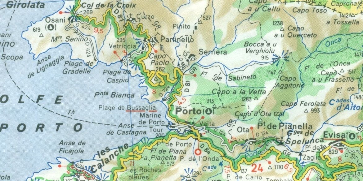
chevron = direction of climb
single chevron > = 5-9% grade
double chevron >> = 9-13%
triple chevron >>> = +13%
yellow D road = secondary
white D road = smaller secondary
green highlight = scenic route
blue beams = scenic view point
black blocks = layout of buildings in small villages
green overlay = forested area
triangle icon = municipal campgrounds to be found in Osani, Porto and Evisa
twisty turns = you're on a fun road!
The main difference between paper and digital maps is that paper is being printed at a much higher resolution and the "screen" is also much, much larger.
Paper is very good for overviews.
What digital maps give you is searchability, maps at very different zoom levels conveniently, and cheaper updates (often). (The paper map you show is missing lots of detail because it's at a fairly low zoom level).
04-27-22, 12:22 PM
#28
Senior Member
L>R RWGPS, Google, Michelin. (zoom levels reduced for this screen shot) RWGPS and Google look like blank pages! Michelin image is about 7" high on printed map, also available online. Only one of their zoom levels look like the printed version.
Last edited by BobG; 04-27-22 at 12:34 PM.
04-27-22, 12:35 PM
#29
Senior Member
Join Date: Sep 2007
Location: Far beyond the pale horizon.
Posts: 14,314
Mentioned: 31 Post(s)
Tagged: 0 Thread(s)
Quoted: 4282 Post(s)
Liked 1,376 Times
in
957 Posts
Just a quick scan to show the artistic quality and content of Michelin. Click on the above image and it will fill the entire screen of a desktop or laptop. The folded 4.5"x10" map of Corsica opens up to 42"x20" on a picnic table.
L>R RWGPS, Google, Michelin. (zoom levels reduced for this screen shot) RWGPS and Google look like blank pages! Michelin image is about 7" high on printed map.
L>R RWGPS, Google, Michelin. (zoom levels reduced for this screen shot) RWGPS and Google look like blank pages! Michelin image is about 7" high on printed map.
Detail of Porto:
Highlighting the scenic roads would be easy enough to do on a digital map.
https://www.viamichelin.com/web/Maps...evisa%20france
The digital maps have to work on screens that might be 3" x 5.5".
There are different advantages to both.
Last edited by njkayaker; 04-27-22 at 01:02 PM.
 04-27-22, 02:19 PM
#31
Member
The OP asked "which planning system do you trust?" in the context of a tour in France. The key word there is "planning", and for me at least, the big picture of a paper map is vastly superior for planning purposes than anything electronic for France. That is particularly true in France thanks to the abundance of outstanding paper maps available. On a paper map, I can see at a glance small roads deemed "scenic" and villages marked as "picturesque" that are near sights we intended to visit. Since the OP hasn't responded to any mention of paper maps, I am guessing that the OP actually meant "which electronic tools".
FWIW, I planned our general route in the Perigord region in France for a tour with 2 friends 4 years ago. They wanted me to do the planning because they have really liked the routes and sights along the routes that I had found on our previous tours together, including tours within France. I used both IGN & Michelin maps. I also did research online for sights we would visit, and tripadvisor was helpful for selecting those, along with discussions with my friends. We visited many castles, caves, gardens, and medieval villages. While we were actually riding, the maps I had downloaded on maps.me on my phone were helpful for navigating and finding specific places in towns & villages. While we were there, we rode on 2 new trails I learned about which weren't on any electronic or paper maps yet. One was a paved rail-trail near Sarlat. It was a gorgeous trail. The other was a new canal towpath that had just opened near Montauban. I learned about the rail-trail from a B&B owner we stayed with, and I read about the new canal towpath online. We rode toward the canal and asked a local man about access points to the towpath when we were within a km of the canal.
My last tour pre-pandemic was in Colombia, and planning for that tour was entirely different than for France. I did a lot more research online and my phone & tablet were more important on the ground than in France.
04-27-22, 02:30 PM
#32
Senior Member
Join Date: Sep 2015
Location: QC Canada
Posts: 1,990
Bikes: Custom built LHT & Troll
Mentioned: 12 Post(s)
Tagged: 0 Thread(s)
Quoted: 858 Post(s)
Liked 151 Times
in
108 Posts
Or even more to the point: 3 screen captures from bRouter using different themes. Notice at the far right the display options (more are available). Notice also that the route is colored in deep red when elevation is rapidly increasing, and in blue when it is decreasing. I sympathize with paper lovers, but for route planning, there are better tools. (WRT size, while it is true that a phone is uncomfortably small, computer monitors can saturate your field of vision)
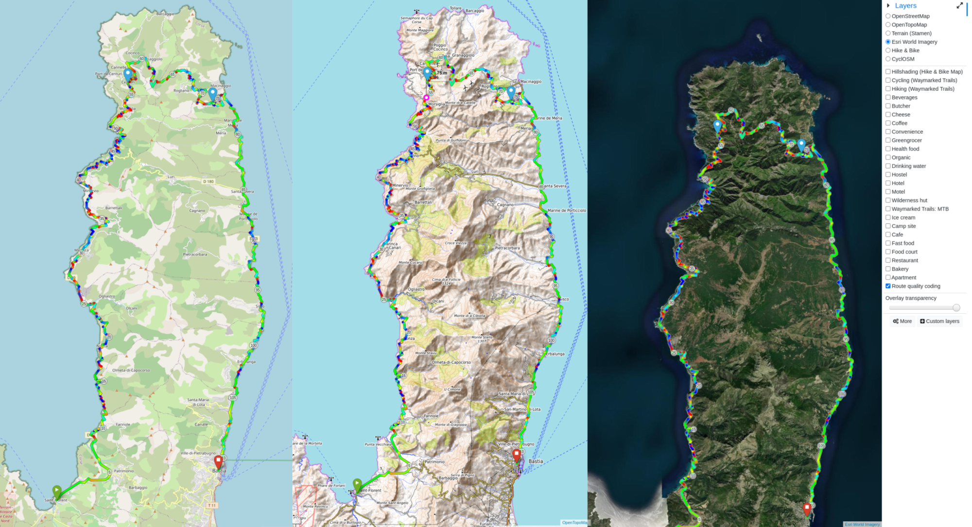
3 shots taken from bRouter, with different terrain renderings.
3 shots taken from bRouter, with different terrain renderings.
Likes For gauvins:
04-27-22, 03:02 PM
#33
Senior Member
Join Date: Sep 2007
Location: Far beyond the pale horizon.
Posts: 14,314
Mentioned: 31 Post(s)
Tagged: 0 Thread(s)
Quoted: 4282 Post(s)
Liked 1,376 Times
in
957 Posts
The key word there is "planning", and for me at least, the big picture of a paper map is vastly superior for planning purposes than anything electronic for France. That is particularly true in France thanks to the abundance of outstanding paper maps available. On a paper map, I can see at a glance small roads deemed "scenic" and villages marked as "picturesque" that are near sights we intended to visit. Since the OP hasn't responded to any mention of paper maps, I am guessing that the OP actually meant "which electronic tools".
I have no issues with people talking about the uses and advantages of paper maps (I thought that was interesting) but you didn't the concerns the OP expressed at all.
Last edited by njkayaker; 04-27-22 at 03:12 PM.
04-27-22, 03:34 PM
#34
Full Member
I do not look at elevation totals at all.
If possible, I look at elevation profiles so I can see what the bigger hills look like. And even the small ones can be worse if steep, if possible I like to see what the percent grades are.....
My point is that in this case, just using different base maps in the same software will give you different data. I might look at height of individual hills, but I do not look for totals.
04-27-22, 03:46 PM
#35
Senior Member
Join Date: Sep 2007
Location: Far beyond the pale horizon.
Posts: 14,314
Mentioned: 31 Post(s)
Tagged: 0 Thread(s)
Quoted: 4282 Post(s)
Liked 1,376 Times
in
957 Posts
This. If my app accumulates and sums the elevation gain of every pebble my tire climbs, my total elevation gain after 50 miles could be enormous. If I was looking in Google Maps for example, I would look at the one day's route alone and I would examine the profile of the elevation changes over meaningful distances. The data could be off with respect to shorter distances, but it seems less probable that it would be off by hundreds of feet over a 5 or 10 mile climb.
The estimates based on maps tends to be lower than the actual measured gain. The best way of measuring gain is barometric pressure but it's not perfect. That isn't sensitive enough to measure "every pebble" either.
Elevation gain is a rough estimate of ride difficulty (it doesn't include grade). Even with problems, it's not unreasonable to consider it in planning.
Last edited by njkayaker; 04-27-22 at 03:49 PM.
04-27-22, 04:04 PM
#36
Senior Member
Join Date: Apr 2021
Posts: 4,083
Mentioned: 6 Post(s)
Tagged: 0 Thread(s)
Quoted: 2333 Post(s)
Liked 2,097 Times
in
1,314 Posts
I must suck.
I have never been able to plan a tour more than one day forward.
Ultimately, I decided to plan one day at a time and to only guess what I thought was 60% of my capacity. When the **** hits the fan, I had something left over to deal with it. Nonetheless, I got in trouble three times over the years.
BTW.....Michelin maps rock.
04-27-22, 04:41 PM
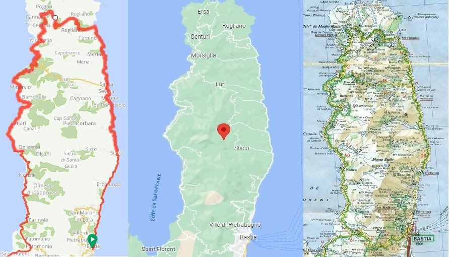
#37
Senior Member
I don't think the OP will need to zoom in much for detail. The D80 route around Cap Corse is one continuous loop, the big picture should be fine. The OP was more concerned with elevation gain thus my suggestion to check the admittedly crude chevrons on the paper map. I see nothing greater that single chevrons indicating 5-9% grades. Maybe gauvin's bRouter app will work better for him.
Take a ride with the Google Street View guy. It looks like a classic loop!
Take a ride with the Google Street View guy. It looks like a classic loop!
04-27-22, 04:47 PM
#38
Senior Member
Join Date: Sep 2007
Location: Far beyond the pale horizon.
Posts: 14,314
Mentioned: 31 Post(s)
Tagged: 0 Thread(s)
Quoted: 4282 Post(s)
Liked 1,376 Times
in
957 Posts
It might be useful in towns. They might also not always be doing this specific route.
The chevrons are useful but might not be sufficient (since they really don't provide much info about the length of climbs.
It seems this route was an example. So, advice that works generally might be helpful.
It seems this route was an example. So, advice that works generally might be helpful.
Last edited by njkayaker; 04-28-22 at 09:21 AM.
04-28-22, 09:32 AM
#39
Senior Member

Join Date: Jun 2016
Location: Boston Roads
Posts: 975
Bikes: 2012 Canondale Synapse 105, 2017 REI Co-Op ADV 3.1
Mentioned: 14 Post(s)
Tagged: 0 Thread(s)
Quoted: 507 Post(s)
Liked 237 Times
in
133 Posts
Lots of interesting discussion here but I believe a lot of it misses the original request by the OP. In my experience, all of the elevation estimates are just that. Estimates. That is corroborated by the research in the thread, where multiple providers differ +/- 20%. It also highly depends on the area, some areas are better-mapped; more remote areas probably aren't.
Here's a writeup on where RWGPS gets its elevation data: 2 decades old SRTM, 90-meter resolution (though they do interpolate between points)
GMaps gets its data from numerous sources, sounds like mostly SRTM outside of US but a lot of modern LIDAR-based data is trickling in.
Strava says they use user data from devices with barometric sensors. Here's a post with more details.
So, everyone does their own thing, but even for those who use the same base data like STRM, the way they perform interpolation may be different from one source to the other.
You can do your best but might I suggest that you are taking on an impossible burden of managing another person's level of comfort and happiness? There's only so much you can do there, the best bet is probably to manage expectations by providing a range of elevations to cover for the day and have a backup plan to cut a day short in case it turned out that the elevation estimate was lower than actual.
Finally, Corsica is amazing but also very hilly in places as you can already tell. I'd say better to plan on the conservative side which will allow you to enjoy it more.
Here's a writeup on where RWGPS gets its elevation data: 2 decades old SRTM, 90-meter resolution (though they do interpolate between points)
GMaps gets its data from numerous sources, sounds like mostly SRTM outside of US but a lot of modern LIDAR-based data is trickling in.
Strava says they use user data from devices with barometric sensors. Here's a post with more details.
So, everyone does their own thing, but even for those who use the same base data like STRM, the way they perform interpolation may be different from one source to the other.
that'll be the end of the trip. He'll just call a taxi and hightail it back to the airport.
Finally, Corsica is amazing but also very hilly in places as you can already tell. I'd say better to plan on the conservative side which will allow you to enjoy it more.
04-29-22, 08:15 PM
#40
Senior Member
Thread Starter
Join Date: May 2008
Location: Toronto, Canada
Posts: 901
Bikes: (shortlist) Cyclops, Marinoni, Mariposa, Air Firday, Pocket Rocket Pro, NWT, SLX Fuso, Claude Pottie (France) x3, Masi Team 3v, Lemond Zurich, Bianchi OS
Mentioned: 2 Post(s)
Tagged: 0 Thread(s)
Quoted: 169 Post(s)
Liked 34 Times
in
27 Posts
in the 1990s I used to have to sit down and manually highlight my suggested routes on paper michelin maps to hand out to my riding clients. I bought Michelin maps by the dozens, hundreds.
Once on the road my first stop would be a Presse store to buy a paper map.
But Yes, at this preliminary planning stage I was thinking electronic tools. Partly because I do not want to be dashing all over town trying to find Michelin maps of Corsica (Yellow Michelin maps are not at all easy to find here in Canada. Mallorca maps were impossible.) but also because we haven't settled on a destination, our focus may drift to the Canary Islands or Provence or... who knows where..
At this point I want to sketch out preliminary feasibility and a time table. But also because I want to dovetail the route planning with hotel planning (this will be a credit card tour) and for that aspect online services are far superior.
Plus I already have a huge collection of print Michelin maps (though not yet one of Corsica.)
04-29-22, 09:20 PM
#41
Senior Member
I have run a European bike travel business for 30 years (winding down now) and Michelin maps were always my lifeblood. I used to LOVE pouring over them for their little nuances "after this sharp corner there'll be a 1 chevron rise and then over the bridge over the creek and then the village and then after the lookout point and the campground...." Yes, the level of detail and the amount of information is astounding.
in the 1990s I used to have to sit down and manually highlight my suggested routes on paper michelin maps to hand out to my riding clients. I bought Michelin maps by the dozens, hundreds.
Once on the road my first stop would be a Presse store to buy a paper map.
But Yes, at this preliminary planning stage I was thinking electronic tools. Partly because I do not want to be dashing all over town trying to find Michelin maps of Corsica (Yellow Michelin maps are not at all easy to find here in Canada. Mallorca maps were impossible.) but also because we haven't settled on a destination, our focus may drift to the Canary Islands or Provence or... who knows where..
At this point I want to sketch out preliminary feasibility and a time table. But also because I want to dovetail the route planning with hotel planning (this will be a credit card tour) and for that aspect online services are far superior.
Plus I already have a huge collection of print Michelin maps (though not yet one of Corsica.)
You'll then know that in regard to your friend, it would be prudent to try to ride together as much as possible and gather a feel for his or her capabilities, and then plan conservatively with meters gained and distance with what you know they can handle.
I still suspect the online route options must be fairly close, perhaps doing some Google maps altitude gain only for segments might help.
Having ridden a lot in mountains, I would say the most important thing for your friend is to ride hills a lot. I've found over the decades that the mental aspect is just as important, and the more climbing rides you both do is crucial to a more enjoyable trip.
And seriously, having gearing that suits having 20,25lbs on the bike in constant up and down, is super important--and hopefully you guys aren't too "Roady" minded, ie too much htfu mindset.
Here in Montreal there is, used to be anyway precovid, a few good map stores \travel stuff books, where one could find good maps.
04-30-22, 05:29 AM
#42
Senior Member
Join Date: Aug 2010
Location: Madison, WI
Posts: 11,248
Bikes: 1961 Ideor, 1966 Perfekt 3 Speed AB Hub, 1994 Bridgestone MB-6, 2006 Airnimal Joey, 2009 Thorn Sherpa, 2013 Thorn Nomad MkII, 2015 VO Pass Hunter, 2017 Lynskey Backroad, 2017 Raleigh Gran Prix, 1980s Bianchi Mixte on a trainer. Others are now gone.
Mentioned: 48 Post(s)
Tagged: 0 Thread(s)
Quoted: 3478 Post(s)
Liked 1,476 Times
in
1,152 Posts
I have run a European bike travel business for 30 years (winding down now) and Michelin maps were always my lifeblood. ...
Once on the road my first stop would be a Presse store to buy a paper map.
But Yes, at this preliminary planning stage I was thinking electronic tools. ...
Once on the road my first stop would be a Presse store to buy a paper map.
But Yes, at this preliminary planning stage I was thinking electronic tools. ...
As I noted in in post 20 above, I use Komoot on the internet with browser and I have an example attached as a PDF. You asked for total elevation, that provides that.
I also use Mapsource. But I would not recommend the Garmin product because it is discontinued and unsupported, I have been using it for over a decade and am quite used to it so I will continue to use it. I do not know where you can find Garmin compatible topo basemaps for Corsica or any other non-USA location, that is another reason that I would be hesitant to recommend this to a new user as I can't suggest where to get elevation data.
Since you are doing a credit card trip and you have been in the business before, if I was in your shoes I would see what others (competitors) have done for a trip itinerary and route for ideas.
Good luck with your trip.
04-30-22, 07:15 AM
#43
Senior Member
I have run a European bike travel business for 30 years (winding down now) and Michelin maps were always my lifeblood. I used to LOVE pouring over them for their little nuances "after this sharp corner there'll be a 1 chevron rise and then over the bridge over the creek and then the village and then after the lookout point and the campground...." Yes, the level of detail and the amount of information is astounding.
in the 1990s I used to have to sit down and manually highlight my suggested routes on paper michelin maps to hand out to my riding clients. I bought Michelin maps by the dozens, hundreds.
Once on the road my first stop would be a Presse store to buy a paper map.
But Yes, at this preliminary planning stage I was thinking electronic tools. Partly because I do not want to be dashing all over town trying to find Michelin maps of Corsica (Yellow Michelin maps are not at all easy to find here in Canada. Mallorca maps were impossible.) but also because we haven't settled on a destination, our focus may drift to the Canary Islands or Provence or... who knows where..
At this point I want to sketch out preliminary feasibility and a time table. But also because I want to dovetail the route planning with hotel planning (this will be a credit card tour) and for that aspect online services are far superior.
Plus I already have a huge collection of print Michelin maps (though not yet one of Corsica.)
in the 1990s I used to have to sit down and manually highlight my suggested routes on paper michelin maps to hand out to my riding clients. I bought Michelin maps by the dozens, hundreds.
Once on the road my first stop would be a Presse store to buy a paper map.
But Yes, at this preliminary planning stage I was thinking electronic tools. Partly because I do not want to be dashing all over town trying to find Michelin maps of Corsica (Yellow Michelin maps are not at all easy to find here in Canada. Mallorca maps were impossible.) but also because we haven't settled on a destination, our focus may drift to the Canary Islands or Provence or... who knows where..
At this point I want to sketch out preliminary feasibility and a time table. But also because I want to dovetail the route planning with hotel planning (this will be a credit card tour) and for that aspect online services are far superior.
Plus I already have a huge collection of print Michelin maps (though not yet one of Corsica.)
Being in Quebec, there may be a better chance they would have a Corsica map. Let me know if a quick phone call in French could help, although I suspect someone speaks English there.
cheers
 04-30-22, 07:25 AM
#44
Senior Member
Oh, wanted to mention that a few years ago, my wife and I rode across France, and intended to get a France sim card to use our phones and possible google maps use (I'm a map guy generally)
Unfortunately, despite being perfectly functional in French, the phone company store (one of the main ones in France) were not able to get our phones working. A specific technical issue with our newish phones, but were incompatible with the specific France thing.
Just keep in back of mind, and I'd suggest doing what I did, having a backup off line app on your phone where beforehand you can download Open Source Maps OSM of Corsica. It was easy for me to do this for all the sections from the Atlantic to Switzerland, and was handy to have at times and the app, Maps.me , worked well enough.
This technology is great, and can be so useful. My take on it (may be wrong) is that OSM stuff is fairly up to date.
04-30-22, 09:32 AM
#45

don't try this at home.

Join Date: Jan 2006
Location: N. KY
Posts: 5,965
Mentioned: 10 Post(s)
Tagged: 0 Thread(s)
Quoted: 984 Post(s)
Liked 519 Times
in
357 Posts
Elevation accuracy
I use ridewithgps. For mountain routes with long, steady climbs, I find it's elevation gain totals to be quite accurate. For small rolling terrain, it can underestimate the elevation total. I ride some areas that are all up and down, with most of these hills being less than 60 feet / 20 meters. A 50 mile / 80 km ride there might be 3500 feet / 1000 meters. It's surprising to me how even these tiny hills add up to a lot of effort by the end of the ride. My Garmin might report 3500 feet, but the ridewithgps route showed 3200. That's 10% short, not too bad. Ridewithgps can be inaccurate on short, steep sections of a climb, maybe showing 8% where it's actually 13%. But the average for the whole climb is usually quite accurate.
I use ridewithgps. For mountain routes with long, steady climbs, I find it's elevation gain totals to be quite accurate. For small rolling terrain, it can underestimate the elevation total. I ride some areas that are all up and down, with most of these hills being less than 60 feet / 20 meters. A 50 mile / 80 km ride there might be 3500 feet / 1000 meters. It's surprising to me how even these tiny hills add up to a lot of effort by the end of the ride. My Garmin might report 3500 feet, but the ridewithgps route showed 3200. That's 10% short, not too bad. Ridewithgps can be inaccurate on short, steep sections of a climb, maybe showing 8% where it's actually 13%. But the average for the whole climb is usually quite accurate.
05-01-22, 09:25 AM
#46
Senior Member
It looks like no map of Corsica will really help with avoiding hills. Overall, it seems more mountainous in the interior and flatter around the edges. If you are planning a coastal ride, any detour to the interior is likely to be hillier.
05-01-22, 09:59 AM
#47
Senior Member
It could have been due to my expectations and so maybe pushing harder on the lumpy west coast steep ups and downs where rivers etc met the coast, whereas in the Pyrenees, you tend to find a gear for the moderate steep climbs with switchbacks and measure yourself for a long climb--but no matter, thats what I recall from the west coast trip, that it was harder climbing than I ever expected.
05-01-22, 11:33 AM
#48
Member
I've toured on Corsica and detailed my experience in post #10. Except for the east coast, the coastal roads in Corsica are not flat. Except for the east coast, the traffic levels were light (in June). Except for the east coast, the scenery was magnificent. In other words, don't tour on the east coast of Corsica, unless, like me, you need to get somewhere quickly to catch a ferry or flight.
Likes For axolotl:
05-01-22, 01:47 PM
#49
Senior Member
Good points, djb and axolotl, I have been similarly surprised by riverside roads. Not infrequently, what appears on a map to be a nice meander along a river turns into an epic. The net gain or loss over the route may be slight, but the tributaries to the river have incised numerous, steep sided little valleys so that the effect is like riding along the edge of a giant saw. Somehow all those small, but steep climbs really take a toll on me.
05-01-22, 03:56 PM
#50
Senior Member
Join Date: Jan 2010
Posts: 39,376
Mentioned: 211 Post(s)
Tagged: 1 Thread(s)
Quoted: 18471 Post(s)
Liked 15,737 Times
in
7,399 Posts
I've toured on Corsica and detailed my experience in post #10. Except for the east coast, the coastal roads in Corsica are not flat. Except for the east coast, the traffic levels were light (in June). Except for the east coast, the scenery was magnificent. In other words, don't tour on the east coast of Corsica, unless, like me, you need to get somewhere quickly to catch a ferry or flight.
