


Seattle to Phoenix - looking for route suggestions, tips
 02-08-14, 03:43 AM
#1

Banned.
Thread Starter

Join Date: Jul 2009
Location: PAZ
Posts: 12,294
Mentioned: 255 Post(s)
Tagged: 0 Thread(s)
Quoted: 2588 Post(s)
Liked 4,824 Times
in
1,709 Posts
Seattle to Phoenix - looking for route suggestions, tips
A BF member since 2009, I hang out for the most part over in Classic and Vintage. However, this spring I will retire from the Navy after 26 years of active duty and am finally able to begin my preparations for a long-anticipated pan-US unsupported solo ride in the summer of 2015.
I will be settling in Seattle. I have a lot of family and friends in Arizona, so my first semi-mega-mile trip is planned for the title route. But my current duty station location doesn't offer me much in the way of fast internet connectivity, so working out a safe route for this trip has so far been impossible to accomplish.
I'm hoping for submissions from those of you in WA, OR, CA and AZ. Perhaps I can piece together a route with the feedback here, and then once back stateside can map it all out during my 60 days of terminal leave. That would put my start date around the beginning of July.
I'm well-versed in long miles in the saddle (even a couple double-centuries) and will only hit 50 this July. I'm in fairly good shape, particularly as I quit smoking over 3 months ago. However, I've never done more than about 80 to 100 miles a day for longer than 8-10 days in a row - and that kind of mileage as far back as the late 90s.
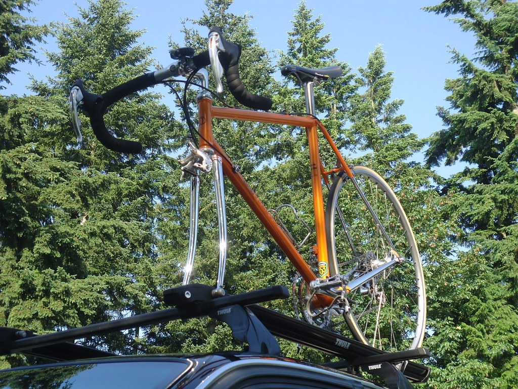
My plan is to do this as a credit card ride. Bike is a road-racing geometry 2004 Davidson custom with mid/late 90s Campagnolo Ergo 8-speed. I will mount a fairly small, vintage Eclipse handlebar bag on my seatpost utilizing Eclipse's SPT (seat post thing) and perhaps add a small handlebar bag, too. Two changes of cycling shorts/jerseys and two changes of apres-ride shorts/T-shirts. Camera, spare tubes, rudimentary tool kit, extra cleats - and I'll eat along the way.
Anyhow, first post so I won't go crazy with details, but this will serve to get this started. Thanks to my buddy scozim who suggested I tap into the knowledge base here.
The ride:
DD
I will be settling in Seattle. I have a lot of family and friends in Arizona, so my first semi-mega-mile trip is planned for the title route. But my current duty station location doesn't offer me much in the way of fast internet connectivity, so working out a safe route for this trip has so far been impossible to accomplish.
I'm hoping for submissions from those of you in WA, OR, CA and AZ. Perhaps I can piece together a route with the feedback here, and then once back stateside can map it all out during my 60 days of terminal leave. That would put my start date around the beginning of July.
I'm well-versed in long miles in the saddle (even a couple double-centuries) and will only hit 50 this July. I'm in fairly good shape, particularly as I quit smoking over 3 months ago. However, I've never done more than about 80 to 100 miles a day for longer than 8-10 days in a row - and that kind of mileage as far back as the late 90s.
My plan is to do this as a credit card ride. Bike is a road-racing geometry 2004 Davidson custom with mid/late 90s Campagnolo Ergo 8-speed. I will mount a fairly small, vintage Eclipse handlebar bag on my seatpost utilizing Eclipse's SPT (seat post thing) and perhaps add a small handlebar bag, too. Two changes of cycling shorts/jerseys and two changes of apres-ride shorts/T-shirts. Camera, spare tubes, rudimentary tool kit, extra cleats - and I'll eat along the way.
Anyhow, first post so I won't go crazy with details, but this will serve to get this started. Thanks to my buddy scozim who suggested I tap into the knowledge base here.
The ride:
DD

Last edited by Drillium Dude; 02-08-14 at 04:10 AM.
 02-08-14, 11:28 AM
#2
Banned
In order to preserve the stripped down look of the vintage bikes you love ..
get a Bike trailer for your Gear .. Left of QR axle is common tow point, for 2 wheel trailers
a substitute QR is used and a Tow Fork to pull a 1 wheel Trailer .. BoB, Xtrawheel popular [in that order]
a 3rd type Burly Travoy Mounts to the seatpost ..
and tows directly behind you like a 1 Wheel trailer , but has 2.
Oregon sees Hundreds of coast riding cyclists , some Canadians start from BC.
and/or Seattle. then go to the Border with Mexico..
a couple guys from Sweden turned left and headed to Florida .. they started in Anchorage AK.
US 101 crosses the Columbia River just a few blocks (.5Mile) from my wee house..
Of course you can head immediately across the North Cascades and go across the high inland parts of
Washington, Oregon and Nevada .... [bring extra Water..]
Last edited by fietsbob; 02-08-14 at 11:35 AM.
02-08-14, 12:16 PM
#3
Senior Member

Join Date: Jan 2007
Location: NE Tx
Posts: 2,766
Bikes: Tour Easy, Linear USS, Lightening Thunderbolt, custom DF, Raleigh hybrid, Felt time trial
Mentioned: 0 Post(s)
Tagged: 0 Thread(s)
Quoted: 0 Post(s)
Likes: 0
Liked 0 Times
in
0 Posts
Check out Adventure Cycling Association, ACA, for route ideas via their maps. The routes are shown on their site. Shown here is my route from the coast to Phx.
Cool bike.
Cool bike.
02-08-14, 12:30 PM
#4
Hooked on Touring
50?? OMG, were you around when they still had dinosaurs?
Anyhoo, the shortest distance between two points is not necessarily a straight line - esp. in July.
I sense that you are thinking down and over - but may I suggest over and down.
Rather than head down to California and over to Arizona, head over to Montana, then down.
Yes, the Pacific Coast route is pleasant in July -
But between L.A. and Phoenix it would be absolutely brutal.
And if you are not on a time clock, why not take in the wildflowers and grizzlies?
The topography of Arizona is such that you can stay on the plateau to just north of Phoenix.
Then zoom down thru Payson without even pedaling for 20 miles.
The interior route would be roughly US 12 east to US 89 south - but with some caveats.
1. From Seattle you can access US 12 via Hwy 410 over Chinook Pass.
Of if you wanted to avoid the heat of the Columbia Basin -
Then you could take the Northern Tier to Sandpoint and Hwy 200 into Missoula.
2. From Missoula you can follow the TransAm to Yellowstone -
Or you can continue on Hwy 200 and over to Helena to US 89 at Ringling
3. From Jackson I would stay on US 89 and Wyo 89 to Evanston, avoiding the SLC metro -
Then cross the Uinta Mtns on Hwy 150 - nice! - and US 189 into Provo.
4. You can follow US 89 all the way to Flagstaff - branching off to visit national parks.
Bryce Canyon, near Panguitch, is high elevation and cool - Zion will be blistering.
I would take US 89A thru Jacob Lake rather than US 89 thru Page
Plus you can visit the North Rim of the Grand Canyon - which is da best.
(If you want to know how to shuttle your bike and hike across, I'll let you know.)
The stretch of US 89 around Cameron can be tricky.
I would definitely loop Hwy 64 and US 180 via the South Rim.
5. You can take Hwy 89A and Hwy 89 thru Sedona to Phoenix - but it is busy.
I think taking Mormon Lake Road to Hwy 87 and down to Payson is better.
South of Payson, Hwy 87 is 4-lane, but very scenic. It will be hot.
There are some ups and downs - but mostly you will be wailing your way into PHX.
Best - J
02-08-14, 02:36 PM
#5
Senior Member
In order to preserve the stripped down look of the vintage bikes you love ..
get a Bike trailer for your Gear .. Left of QR axle is common tow point, for 2 wheel trailers
a substitute QR is used and a Tow Fork to pull a 1 wheel Trailer .. BoB, Xtrawheel popular [in that order]
a 3rd type Burly Travoy Mounts to the seatpost ..
and tows directly behind you like a 1 Wheel trailer , but has 2.
Oregon sees Hundreds of coast riding cyclists , some Canadians start from BC.
and/or Seattle. then go to the Border with Mexico..
a couple guys from Sweden turned left and headed to Florida .. they started in Anchorage AK.
US 101 crosses the Columbia River just a few blocks (.5Mile) from my wee house..
Of course you can head immediately across the North Cascades and go across the high inland parts of
Washington, Oregon and Nevada .... [bring extra Water..]
get a Bike trailer for your Gear .. Left of QR axle is common tow point, for 2 wheel trailers
a substitute QR is used and a Tow Fork to pull a 1 wheel Trailer .. BoB, Xtrawheel popular [in that order]
a 3rd type Burly Travoy Mounts to the seatpost ..
and tows directly behind you like a 1 Wheel trailer , but has 2.
Oregon sees Hundreds of coast riding cyclists , some Canadians start from BC.
and/or Seattle. then go to the Border with Mexico..
a couple guys from Sweden turned left and headed to Florida .. they started in Anchorage AK.
US 101 crosses the Columbia River just a few blocks (.5Mile) from my wee house..
Of course you can head immediately across the North Cascades and go across the high inland parts of
Washington, Oregon and Nevada .... [bring extra Water..]
However, I think that some warmer riding wear and raingear would really be wise to bring--the northern west coast can get chilly rainstorms even in the dead of summer--like in 2013. Plus if he takes the high inland route through Arizona, those mornings can be chilly.
Since it's a credit card tour, it may be possible for the OP to get through the desert by riding in the early morning hours and getting to his motel before noon, a good set of lights and batteries would be a really good idea! Plus call ahead to your planned motel stop, since many are closed during the height of summer. And a lot depends on how much the OP can acclimate to riding in extreme heat--some folks love it, but for others, it would be a literal killer.
Also, if headed down the Pacific coast in tourist season, it may be difficult to find reasonably-priced rooms, especially in the more remote sections, such as the Northern Cal coast and Big Sur. Some state parks and private campgrounds have cabins and RVs for rent by the night, though.
Last edited by stevepusser; 02-08-14 at 03:01 PM.
02-08-14, 02:44 PM
#6
Banned
only carrying sawn off toothbrushes and the like.. RBW / Carradice's Classic canvas stuff should be fine ..
camper saddle bag
maybe some shelter may be useful to carry.. if overnights are further apart than convenient.
camper saddle bag
maybe some shelter may be useful to carry.. if overnights are further apart than convenient.
02-08-14, 05:40 PM
#7
Senior Member
Join Date: Dec 2010
Location: Above ground, Walnut Creek, Ca
Posts: 6,681
Bikes: 8 ss bikes, 1 5-speed touring bike
Mentioned: 0 Post(s)
Tagged: 0 Thread(s)
Quoted: 86 Post(s)
Likes: 0
Liked 4 Times
in
4 Posts
the ACA Pacific to San Diego the the ACA Southern, is probably the simpliest, not necessarily the shortest, and pretty safe route. but, as mentioned, the route through Montana, ACA northern to just east of Glacier then a custom route through western Wy could be great, and would avoid potentially high temps in S. Cal and AZ.
if so, you may, depending on your route, have a decision to make in northern, central UT. go SouthWest or SouthEast around Capitol Reef National Park. one will lead you through the Kaibab the other the Four Corners area. both nice, but the Four Corners is pretty desolate, although i backpacked through there to Gallup an number of years ago with little trouble.
if so, you may, depending on your route, have a decision to make in northern, central UT. go SouthWest or SouthEast around Capitol Reef National Park. one will lead you through the Kaibab the other the Four Corners area. both nice, but the Four Corners is pretty desolate, although i backpacked through there to Gallup an number of years ago with little trouble.
02-09-14, 04:46 AM
#8
Banned.
Thread Starter
Join Date: Jul 2009
Location: PAZ
Posts: 12,294
Mentioned: 255 Post(s)
Tagged: 0 Thread(s)
Quoted: 2588 Post(s)
Liked 4,824 Times
in
1,709 Posts
Hmmmmm - some interesting suggestions so far. I like the ACA map idea, and am currently checking out their website to determine which maps I will need to cover my entire route. I'm still having my standard issue checking out the site, however: slow internet speed. It's satellite-only out here and that's not changing anytime soon.
I could go coast or across WA and then down; either way would work for me. I just need to identify areas where there may be long gaps between places to get water and lodging. As for heat, I've been riding the bike in the humid, 90+ degree heat of the central Indian Ocean for the past 12 months, so there isn't much in the way of hot weather that will be new to me other than to say I'm looking forward to riding in some dry heat
Well, I can't even seem to get the interactive overall route map to load up right now, so perhaps I'll have to keep trying at a later time/date.
I have wondered if I'd run into some areas where I might need to be bundled up more that what I was planning for. I wonder: would leg/arm warmers be enough? I drove through the Cascades a few summers ago and even at elevation (Diablo, for instance), the temps were approaching 100 degrees. I think I have to do some research as to the typical weather in the regions I may be going through as well.
I do want to carry a minimal amount of stuff with me, I know that. How minimal it remains to be seen. I won't skimp on tools/repair items; that's a given for me.
I don't want to go too desolate, but I would like get a few oportunities to be out there with minimal car/bike interaction.
Thanks for all the suggestions so far, particularly the ACA link. If I can ever get the maps to load they appear (from the video) to be a treasure trove of all the info I could possibly need for my trip planning and execution.
DD
02-09-14, 07:10 AM
#9
Senior Member
DD, Dry heat is different from heat plus humidity, you need to be more careful about hydrating. The perspiration evaporates more quickly leaving the impression that one's not sweating as much. There is plenty of internet info regarding hydrating.
Look at the ultra light touring threads in this forum as there is good info to pick through.
Brad
Look at the ultra light touring threads in this forum as there is good info to pick through.
Brad
02-09-14, 08:45 AM
#10
Banned.
Thread Starter
Join Date: Jul 2009
Location: PAZ
Posts: 12,294
Mentioned: 255 Post(s)
Tagged: 0 Thread(s)
Quoted: 2588 Post(s)
Liked 4,824 Times
in
1,709 Posts
DD, Dry heat is different from heat plus humidity, you need to be more careful about hydrating. The perspiration evaporates more quickly leaving the impression that one's not sweating as much. There is plenty of internet info regarding hydrating.
Look at the ultra light touring threads in this forum as there is good info to pick through.
Brad
Look at the ultra light touring threads in this forum as there is good info to pick through.
Brad
Thanks for the tip - I'll see if I can't find a few of the ultralight touring threads of which you wrote. They'd probably do me a world of good to read, huh?
DD
02-09-14, 10:59 AM
#11
Senior Member
Brad
02-09-14, 11:25 AM
#12
Banned
WSDOT and ODOT and other states offer online map access as well ..
DeLorme is another good series of maps , both in paper atlas and digital forms .
https://www.delorme.com/mapstore/
DeLorme is another good series of maps , both in paper atlas and digital forms .
https://www.delorme.com/mapstore/
02-09-14, 01:23 PM
#13
Hooked on Touring
Water, eh?
Drawing a straight line from Seattle to Phoenix would put you thru a whole hunk of Nevada.
I love Nevada - have biked it every direction - maybe 6 or 8 times.
But there are long gaps between civilization and not much water to be found.
Remember the old standby - not to be used when you are parched -
Hold your water bottle out with your left arm as a car is going by.
Most people traveling have water with them and quite a few will stop.
Based on that - if an overlook or rest stop has no water - just a portalet -
Ask other people who are stopping if they have any water.
Usually it results in a nice conversation and sometimes an apple or banana, too.
The sweetest water I ever drank was from a cattle trough.
Actually, from the hose coming into a cattle trough. Cold, clear, pure.
Quite a few ranch wells in remote spots are still powered by windmills.
Then there are DOT road crews -
They almost always have a mondo cooler of ice-cold water in the truck.
And they will usually welcome the opportunity to take a break.
Just some ideas - - J
02-09-14, 01:45 PM
#14
Banned.
Thread Starter
Join Date: Jul 2009
Location: PAZ
Posts: 12,294
Mentioned: 255 Post(s)
Tagged: 0 Thread(s)
Quoted: 2588 Post(s)
Liked 4,824 Times
in
1,709 Posts
^ How about that Montana route? Any scary waterless sections? I'm pretty familiar with WA and AZ, but I've only driven (fast) through Montana
Great suggestions, btw. I'll be printing out a lot of stuff in this thread and carry the suggestions along with me!
DD
Great suggestions, btw. I'll be printing out a lot of stuff in this thread and carry the suggestions along with me!
DD
02-09-14, 02:28 PM
#15
Senior Member
In the mountains, you can get snow any time of year. I've had it snow all night at 7000 ft near Lake Tahoe in mid-July, combined with 50 mph winds. This is unusual, yes, so maybe one can hunker down in a motel until the storm passes, but the mountains can still generate local convective thunderstorms that'll give you cold rain, hail, and hypothermia faster than you think possible. This is standard summer weather. I'd carry some thermal fleece and some thin waterproof rain jackets,pants,and gloves, especially since you seem to be acclimated to the tropics. Though I try and wait out these kinds of showers in shelters when on tour, sometimes they still just catch you on the road and you have to grin and bear it. Shoot, last Memorial day weekend, I did an overnight in the San Diego mountains, and it went down to 25 F overnight at the campground at just under 4000 ft, and that's not unusual.
Even normal early morning summer temperatures at Lake Tahoe and Truckee, at only 6000 feet, drop into the low 30s or upper 20's, due to the very dry air, radational cooling, and cold air drainage.
Along the coast, there's a cold current that flows south, so it can be cool (low 50's), misty, and overcast all day. Read some tour journals by folks on the "Legget Hill" day in California; almost all of them describe how miserably cold they got on the descent to the coast as they hit the marine layer.
On the other hand, the desert heat is tough--no clouds, no trees, no water, no shade to rest in for the next 20 miles sometimes...I have ridden in the San Diego inland areas when it's been 110 F and over, and I can't drink fluids fast enough to replace what I'm sweating out. Two quarts an hour at a bare minimum, and any extra water gets poured onto my head and jersey as auxiliary sweat. You really need to make sure your rest/water stops are going to actually be there.
02-09-14, 06:56 PM
#16
Hooked on Touring
If you were to ride east then south via Yakima, Lewiston, Missoula, Yellowstone, Evanston, Provo, Kanab, and Payson - - I do not think you would ever be more than 30 miles between water, more often 20 miles. Also, there would be motels/cabins at 20/30/40 mile intervals - - but near Yellowstone and Grand Canyon you would probably need reservations to insure availability. That's a bit hard to do when you are touring - but once you had an idea of your range, you make reservations a week into your trip.
02-09-14, 09:34 PM
#17
deleteme
Join Date: Feb 2008
Location: PNW lifer
Posts: 582
Bikes: deleteme
Mentioned: 0 Post(s)
Tagged: 0 Thread(s)
Quoted: 50 Post(s)
Likes: 0
Liked 2 Times
in
2 Posts
Mid Sept Leave date: Some Random Way to Hood River Oregon -> Old Columbia Hwy -> The Dalles -> Bend -> Reno -> Death Valley (Not camping could be spendy)-> Vegas -> Phoenix
PS: Nice bike but Gen 1 Ergos are uggg. I have some on my period piece.
PS: Nice bike but Gen 1 Ergos are uggg. I have some on my period piece.
Last edited by escii_35; 02-09-14 at 09:38 PM.
02-09-14, 10:07 PM
#18
Banned.
Thread Starter
Join Date: Jul 2009
Location: PAZ
Posts: 12,294
Mentioned: 255 Post(s)
Tagged: 0 Thread(s)
Quoted: 2588 Post(s)
Liked 4,824 Times
in
1,709 Posts
When I upgraded the Davidson from vintage Super Record - and in the process giving birth to my first, and so far only, modern-age brifter bike - I got a lot of feedback from the guys on C&V. I felt lucky to have found this first-gen pair of Ergos for a few reasons, but mainly because the black coating on the bodies had been completely removed. Since I like to mod parts, they became the centerpiece for a modern drillium Ergo group.
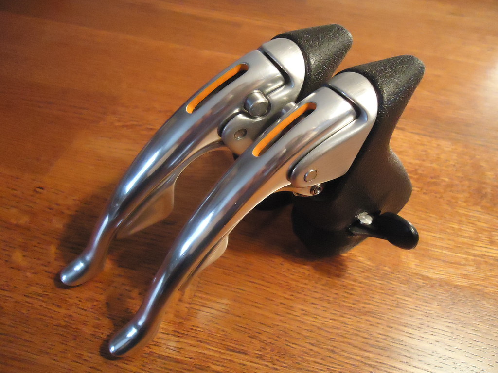
In application, they've been flawless. Is your "uggg" performance- or aesthetics-related? I will be swapping out the TI cogset for this trip for my spare steel set which has a much larger range.
I've done a cursory (and slow) Google Maps scan of the route jamawani has mapped out and that looks like a good one - particularly as I've never been to Yellowstone, not to mention Montana. And I liked his earlier remark about taking my time to see the wildflowers and the grizzlies, although I hope to avoid the grizzlies, to be honest
DD
02-09-14, 11:04 PM
#19
Senior Member

Stuff I have learned cc-touring the West: 1) Fenders. 2) Give your body a complete rest day periodically. 3) Nothing wrong with the nice wide shoulders of an Interstate when permitted and you have to make time. 4) Try and re-schedule to a September departure.
02-10-14, 01:41 AM
#20
Member
Join Date: Apr 2013
Posts: 45
Mentioned: 0 Post(s)
Tagged: 0 Thread(s)
Quoted: 0 Post(s)
Likes: 0
Liked 0 Times
in
0 Posts
Here's a route idea. Ride to Fauntleroy. Take the ferry to Vashon Island. Ride down to Talequah. Take the ferry to Tacoma. (Generally) take Vassault to the footbridge over SR-16 (if you plan the route you can avoid a steep hill). Then, the Scott Pearson Trail to its eastern terminus. Then ride to Yakima Ave., go South, and make your way to Park Ave. Park Ave. south all the way to Spanaway Park. Get on SR-7 southbound after you can't ride any more residential streets. Then SR-7 to SR 507 to Yelm. SR-507 can have a little traffic (from JBLM). Get on the trail (it's really nice) and ride to Tenino. Then take the Seattle to Portland route down to Portland (it's online). You can check out almost all of this route on Google Maps.
02-10-14, 07:56 PM
#21
Banned.
Thread Starter
Join Date: Jul 2009
Location: PAZ
Posts: 12,294
Mentioned: 255 Post(s)
Tagged: 0 Thread(s)
Quoted: 2588 Post(s)
Liked 4,824 Times
in
1,709 Posts
I'm noticing September keeps popping up as a suggestion for the start date. My only concern is colder weather if I start later in the summer. Anyone have any feedback as to expected temps in Montana during September? A later start would actually be better for me, but I've planned for June/July looking for warm and even hot weather across the board.
Thanks to all for the suggestions so far. Currently I'm leaning towards jamawani's suggested route, but I'm still open to alternate routes/suggestions.
DD
Thanks to all for the suggestions so far. Currently I'm leaning towards jamawani's suggested route, but I'm still open to alternate routes/suggestions.
DD
02-10-14, 08:31 PM
#22
Ellensburg, WA

Join Date: Aug 2008
Location: Ellensburg, WA
Posts: 3,755
Bikes: See my signature
Mentioned: 77 Post(s)
Tagged: 0 Thread(s)
Quoted: 313 Post(s)
Liked 457 Times
in
160 Posts
It's a toss up in Montana during that time frame. We started the Cino Heroica last year at around 40-45 degrees the first Saturday of September last year. By the afternoon it was mid-70's. The next day was 50-60 degrees and a fierce thunderstorm. The summers in Montana can be hot and also volatile with hail storms. You just have to be a little more prepared.
__________________
1984 Gitane Tour de France; 1968 Peugeot PL8; 1982 Nishiki Marina 12; 1984 Peugeot PSV; 1993 Trek 950 mtb; 1983 Vitus 979; Colnago Super, mid-80's Bianchi Veloce, 1984 or 85 Vitus 979
1984 Gitane Tour de France; 1968 Peugeot PL8; 1982 Nishiki Marina 12; 1984 Peugeot PSV; 1993 Trek 950 mtb; 1983 Vitus 979; Colnago Super, mid-80's Bianchi Veloce, 1984 or 85 Vitus 979
02-10-14, 09:42 PM
#23
Senior Member
Join Date: Apr 2010
Location: Elevation 666m Edmonton Canada
Posts: 2,478
Bikes: 2013 Custom SA5w / Rohloff Tourster
Mentioned: 7 Post(s)
Tagged: 0 Thread(s)
Quoted: 1236 Post(s)
Liked 318 Times
in
245 Posts
I have driven all over the western states. A few years way back I went water skiing/ camping at Priest Lake ID.
I have to agree with leaving mid July and going thru Missoula and on to Helena. Mountain tops are always COLD.
So then he would get to Yellowstone mid Aug when it will be nice 80s deg. Green River and Arches Park are worthy sights. Starting Sept would be goofy + short days also. I always liked early Aug. holidays.
02-10-14, 09:59 PM
#24
Senior Member
Join Date: Dec 2010
Location: Above ground, Walnut Creek, Ca
Posts: 6,681
Bikes: 8 ss bikes, 1 5-speed touring bike
Mentioned: 0 Post(s)
Tagged: 0 Thread(s)
Quoted: 86 Post(s)
Likes: 0
Liked 4 Times
in
4 Posts
my socks froze overnight when i camped outside the Eastern entrance to Glacier Park at Lake St. Marys. oh... it was July. the park ranger just grunted when i mentioned it...
they say Yellowstone (or is it Glacier?) has only three seasons, fall, winter, and spring. i believe it. IIRC it was late September or very early November when i was backpacking through Yellowstone (absolutely NOBODY was in the park) when i had to camp for a few days in about 10 inches of snow. soon as i was out of there and down the other side of the Wind River Range it was glorious! OTOH, if you plan it properly, you can be in and out of either park in a day. otherwise September should be good. early September...
they say Yellowstone (or is it Glacier?) has only three seasons, fall, winter, and spring. i believe it. IIRC it was late September or very early November when i was backpacking through Yellowstone (absolutely NOBODY was in the park) when i had to camp for a few days in about 10 inches of snow. soon as i was out of there and down the other side of the Wind River Range it was glorious! OTOH, if you plan it properly, you can be in and out of either park in a day. otherwise September should be good. early September...
Last edited by hueyhoolihan; 02-11-14 at 12:29 AM.
02-10-14, 10:23 PM
#25
Banned
2 guys from Sweden came thru Astoria 2nd week of November ,
their route plan was turn left in the South end of california , and head to Florida..
they started from Anchorage AK..
(camping gear aboard)
their route plan was turn left in the South end of california , and head to Florida..
they started from Anchorage AK..
(camping gear aboard)