It was 12 noon when I started out. The weather was in the upper '70s and a 6 -8 mph breeze out of the SE. The skies were clear with an occasional cloud. Perfect riding weather.
I set out from the house and got about 300 yds and remembered I left my cell phone and Garmin on the driveway. I circled back and picked them up, pressed "Start" on the Garmin, and headed west to the eastern edge of the East Coast Preserve of the Everglades. It's about 2 mi to the gate that provides access to the levee system. I have to ride to the Sawgrass express way entrance off Atlantic Ave in Coral Springs, and then head south about 200 yds. I ride in the rutted pathway used by cars to get to the gate. It's rough with an occasional mud puddle.
At the access point the gate is locked and there is no provision for hiker/biker access here, but there is a well worn path over the concrete barriers. I have to hoist the 30# Trek 4100 over the gate, then hop the barrier my self. From there it's clear sailing. A huge mountain of gravel is on the left and the roadway is open to the levee. The surface is flat, made up of packed sand and gravel. There are no ruts.
I mount the levee and I have 3 choices. I can head north to Lox road, about 9 mi, and then double back on the levee, or return via the roads on the same route I often ride on my road bike.
Another option would be to head SE on the levee, retracing the route of my first levee ride last Tuesday night. Since the winds are out of the SE, I choose to head west, straight across the East Coast Preserve. It would prove to be a wise choice, one that I would thank myself for many times on the ride.
As I turn the bike to head west on my solo journey, I have many thoughts racing thru my head. Will I happen across a rogue band of drug smugglers dumping a body and have to "off" the unfortunate witness? Will I Come across a hungry gator sunning himself on the parched levee top? Will I slip off the levee and into the murky waters to be swallowed by a feral python? I dismiss these childish fears in favor of a more realistic fear. I realize that I'm on my son's MTB. He has no tool kit. I am without a spare tube or an inflator. If I get out there, it will be a long walk home. I suck it up and start pedaling. I need to be back by 2:30
The levee road is dead straight for about 7 miles.

The surface is slightly rutted by service vehicles, but public motor vehicles are prohibited. Loose coral gravel and the occasional coral outcrop. I keep praying that there is no glass, and that my tires hold up against the sharp coral gravel.
I have a nice little breeze from the SE pushing me west. I look for "floating logs" or "floating tire treads" (gators) in the canal to my right, but I see none. There is the occasional bird floating on the water. At about 5 mi I come to a water level monitoring station. There is a small solar panel on a pole to power the monitoring devices housed in yellow boxes mounted on the iron docks protruding in to the swamp on either side of the road. There is a trail marker indicating 4.7 mi with little hiker and biker icons. At least I know I'm welcome here, despite hopping the fence.
I snapped a picture of the stark "swamp scape" looking SE into the prevailing breeze.

There is nothing but sawgrass and swamp. On the distant horizon I can make out the Condo Towers next to the Sawgrass Mills Mall. Straining I can just make out the top of the Florida Panther's Hockey Arena. Barely visible are some high tension power lines. In about an hour and a half I'll be very close to all those things if all goes according to plan.
As I am pedaling along my eyes strain to see a tiny dot in the distance. It appears to be moving toward me. It grows larger and larger until I can make out the unmistakable silhouette of a cyclist! We pass and nod a casual greeting. I guess I'm not the only fool out here today. And the road must be safe ahead, at least to the first rest point!
Not long after I spot a boat with 2 fishermen in the canal. They must think I'm nuts. I think the same thing about them.
I come across a flock of turkey vultures feasting on a raccoon carcass near the canal shoreline. They fly away as I approach, only to return as I pass by.
Not long after I make the turn and head SW on the levee I see what appears to be a large rock on the road. It transforms into a painted turtle as I draw near. I stop to snap a picture.

He is unfazed by my presence. Don't ask me what the shiny thing on his back is. I didn't see it when I took the picture. Perhaps he is a long haul trucker caring a load north.
Along the way I've seen several Great Blue Heron. These huge majestic birds are common around these parts this time of year. I often see them along the canal in my back yard. It's a treat to see them in the wild. Unfortunately I'm unable to get close enough to snap a picture before they fly off. Many of the landscape pictures are attempts to capture this elusive bird.

The power lines in the background are a sure sign I'm near the western edge of the East Coast preserve. I'm less than a mile from my first rest stop. I'm right on time as it is almost 1pm.
I approach the gate only to find it locked, and like the access point near my home, there is not provision for access by bike or walker. This time I go under the gate, and slide the bike under after me. I stepped back and snapped a shot of my first 11 miles.
The Sawgrass Recreation Park is a public access point for the waterways in the area. This is where the fishermen I saw earlier gained access to the canal. Their truck and trailer are parked next to the boat launch. Ahead there is a small general store and a marina across the road. Gullible tourists are parading out the dock to hop on an air boat for an "everglades tour."

I prop my bike against the fence and take the banana out of my shirt pocket. Time to eat.
I notice a group of tourists huddled along the fence pointing and taking pictures. Sure enough, there is a small gator among the lily pads. I'm sure the locals feed it so as to keep it near. It's in the center of this picture but my lousy camera in my phone just won't pick it up.

Off in the distance is the lock that separates the East Coast preserve from the distant everglades. Across it runs US 27, a major highway running thru the middle of the state. I have to ride on about 2 miles of it to get to the next point on the levee.
The side of the general store is adorn with collages of local nature. The first thing to catch my eye is the skull of a Saber Tooth Tiger. I'm surprised to read that during that prehistoric period this big cat roamed the Everglades.
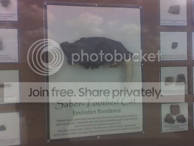
He's the great great great...... great grand daddy of our Florida panther, I guess.
Another collage houses samples of the local game fish. These are a big attraction around here. This far inland is all fresh water but I'm surprised to see that a local fish is a pickerel. I remember as a kid fishing for his cousins in the north east. A worthy game fish, a good fighter, and great eating.
Speaking of eating, I've finished my banana and granola bar and I'm still hungry. I've also drained my 24 oz water bottle so I go in to the general store to get some Gatorade and something else to eat. I pick up a few more granola bars and a qt of Gatorade. That should last me the last 15 mi. Besides, in about 6 mi I'll be at Markham Park. That is the authorized access point and I can always get anything I need there. There is even a bike shop near by incase I've flatted.
At the back of the property I see some signs: Vanishing Species and Reptile Exhibits. A bunch of squalid cages are lined up along the edge of the swamp. A group of tourists are posing for a picture beneath the archway. The locals take every opportunity to separate the tourists from their $$$. A proverbial Florida tourist trap.

I hear the roar of an airboat approaching. I turn to see the loaded boat return with what is not doubt a lot of angry tourist. What has it been, 10 min? And what can you see on an air boat that you can't see from right here? I finish my granola bar, fill my water bottle, and mount the bike. I'm about to set out on the most dangerous leg of the journey: US 27.
To be continued....