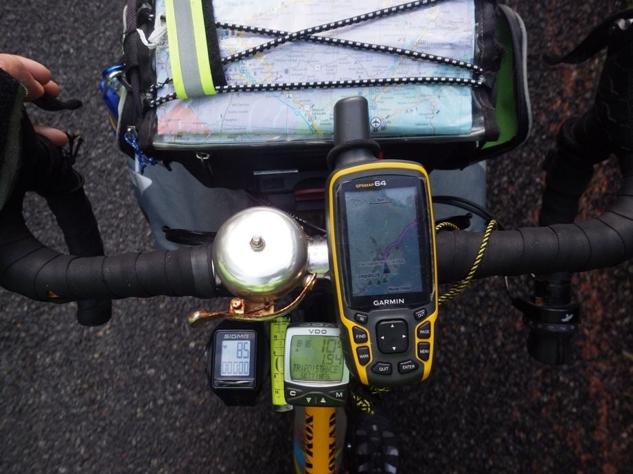
I do not use the same Garmin you use, mine is not a cycling one so I can't really say anything about that. I use a Garmin 64 and I have no clue how it compares to yours.
Each tour I seem to do things a bit differently. I will describe my route planning on the tour I took this past June and July, five weeks in the Canadian Maritimes.
While at home before I went there, I put all the grocery stores and campgrounds that I could find on the internet into the GPS map. I also put those into Maps.Me (an Android app).
Each day I plan out my route. For the route that I take for a specific day, I usually pick a campground as my final destination. If I am running low on food, I might instead pick a destination that is a grocery store that I plan to stop at on the way to the camp ground. To pick that destination I rely mostly on paper map and the Android app Maps.Me for my initial planning. To use that app, I download the maps at home on wifi before I go to where ever I will be because Maps.Me will work off line as long as the maps are in the phone memory. I use that Android app instead of my Garmin for initial planning because my Garmin screen is tiny compared to my phone that has a 5.5 inch screen.
https://play.google.com/store/apps/d...s.pro&hl=en_US
I then tell my Garmin to plot a route to that planed destination, my Garmin has different options for tour cyling, road cycling, car driving, etc. I usually picked tour cycling first. But if the route that the Garmin gave me looked like it would take me off of a route that made sense, then I might pick car driving route to see what that route looked like instead.
If my phone with the Maps.Me route looked to make more sense than my Garmin routing, I would start on that route instead of the Garmin route. But I relied on memory to know where to make the first few turns instead of creating waypoints in the Garmin. Thus, I had my Garmin turned on and mounted on the handlebar, relied on that instead of my phone while riding. My phone on a sunny day is impossible to see, but not the Garmin, so the phone is packed away while I am riding.
If those routes did not look good to me, I might try the Andorid app Komoot. That app only works when connected to the internet. Usually my tours are places where cell service is unreliable at best. Or if there is, I usually do not have a functioning sim card or if I have one that functions it is on a limited data plan. On my Maritimes tour, I did not have a Candian sim card, thus my phone was a wifi only device. Thus, I only used this app on wifi when planning, I never used this app during day to day riding. Also as noted above, my screen is not good enough on a sunny day to see anything on my phone.
https://play.google.com/store/apps/d...droid&hl=en_US
If the Komoot route looked better, I took that route instead of the route my Garmin or Maps.Me route, but again, I just remember where to turn instead of creating way points in the Garmin.
While riding I have the Garmin turned on and it keeps updating my route while I am riding. That way I can see where I am on the screen map. I also have a paper map on top of my handlebar bag to refer to. If I decided to go off of my Garmin route and instead follow a Maps.Me route or a Komoot route, the Garmin re-calculates a new route once I leave the route that the Garmin planned. It might keep recalculating for hours, but I usually leave it on and it keeps updating in the background if I am not following its route.
There are times that none of the electronics works right for the route I wanted to take. Last tour, one day all of the electronic devices told me to take a 15 km road to an intersection, then take a different 15 km road to the next intersection for a total of 30 km. But the electronic devices and the paper map were all clear that there was a 15 km road that would go straight to that endpoint, thus half the distance. So, I disregarded all electronics and took the 15 km road. And it was a great road. I suspect that the electronics were telling me to avoid the road because it was a local road, not a national or provincial highway. After I had gone down that road maybe 10 km, my Garmin finally decided that I was on the best route and quit telling me to turn around and go back to take the long way.
Another example, I decided to ride mostly on the Confederation Trail (gravel rail to trails type of trail) from Charlottetown PEI to the Confederation Bridge which is the only bridge to leave PEI (there also is a ferry on the other end of the island). I made this decision to take the trail system based on paper road map, the trail map, etc. Almost the entire day my Garmin kept telling me to turn onto the highway each time I crossed a highway instead of staying on the trail. It was not until I got off of the gravel trail within maybe 10 km of the bridge that I started to follow the route my Garmin gave me. On this day, I just relied on the Garmin map to show me where the trail was and I followed the trail that was on the screen instead of suggesting routing.
My point is that often I deviate from all of the suggested electronic routes and just use the Garmin to display the map on the screen so I can see where I am relative to where the roads and trails are. On that five week tour, I suspect that I did not follow the Garmin route completely on one out of three days, instead looked at the screen while I was riding and went where it made sense to go.
In other words, sometimes just use the paper map for planning and only use the GPS to tell you were you are on a map on the screen at any given point in time.