Originally Posted by
terrymorse
They are not. Strava still suffers from the inaccuracy of data that users upload.
Like this Strava segment, based on some very noisy user-uploaded data.
The actual grade is about 7%, but Strava says it's 12.3%. Strava says the KOM rider climbed it with a VAM of 2703 meters per hour, which is ridiculous.
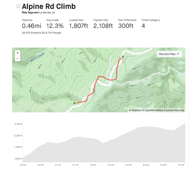 Bad Strava segment
Here's what that segment would look like with "good" GPS data:
 "good" Strava segment
Are you using Strava's option to correct the elevation and distance (browser only)?
My hunch is that Strava defers to the data uploaded by our apps and computers. I usually ride with both a computer (XOSS G+ with barometer) and phone app (usually Wahoo Fitness) as a backup. When I upload two files from two different devices the biggest difference is usually in elevation and terrain profile. In particular the XOSS G+ data produces terrain profiles that look like something drawn with an Etch A Sketch, and barely resembles the actual elevation gain, slopes or terrain profile. Other bike computers with barometers might be better. The XOSS isn't bad for $25-$50 but not a precision instrument.
But when I click the option to correct elevation, the elevation gain and terrain profile usually match most rides on the same route, and seems to correspond with what I've seen and measured. On some routes I've used a phone app to physically measure the grade on some of our short, steep climbs that seemed to be double digits -- we have no mountains here, few extended gradual inclines, and many short, steep punchy hillettes. My measurements usually correspond with Strava's data.
Regarding KOMs on some Strava segments, with the earliest segments created by first users, there's a lot of garbage-in/garbage-out. Some of the earliest Strava segments created here are so ridiculous many of us have created modified segments along the same routes to get something closer to reality. There's one in my area that claims to be a 30% or so grade. There's nothing remotely resembling that in this entire area. Other segments were created using GPS traces that were choppy or wildly off -- such as requiring subsequent cyclists to ride on the opposite side of the road against traffic, or riding through someone's front yard. The people who created those segments should have re-ridden the route to create segments closer to reality, but they didn't.