


Road signs on your commute
 02-05-19 | 03:04 PM
#51

Heck on Wheels


Joined: Sep 2015
Posts: 1,055
Likes: 3
From: USA Midwest
Bikes: In Signature
In
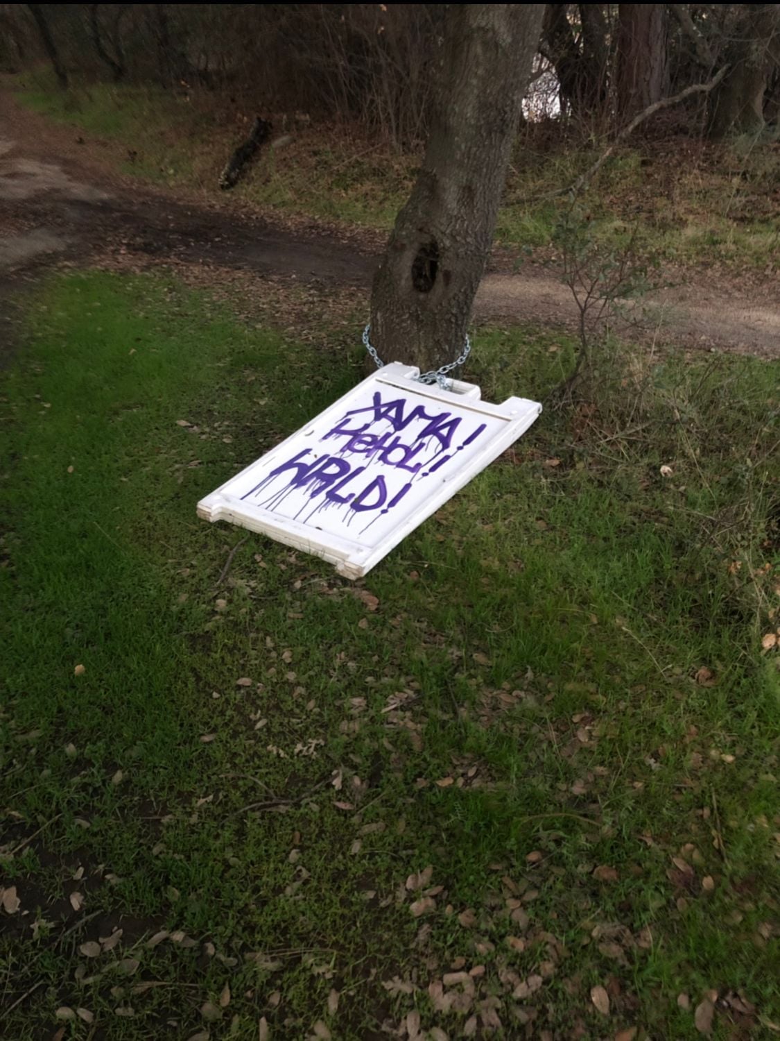
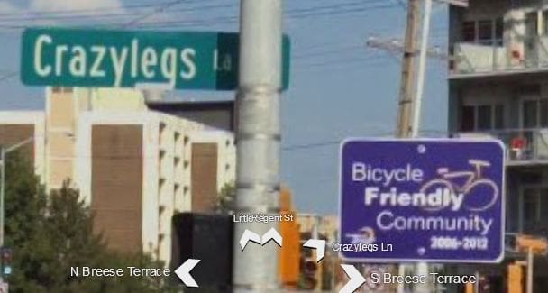
loops around on itself, creating a four-way intersection with Yuma Street, Yuma Street, Yuma Street, and Yuma Court. Worse, the next street over is Yuma Place.
Boston has the intersection of Harvard Ave, Harvard St and Harvard Ct near Coolidge Corner in Brookline. For good measure, Harvard Pl is the next street over:
https://www.google.com/maps/place/Ha...!4d-71.1212181
There are apparently several roads that intersect themselves.
Boston has the intersection of Harvard Ave, Harvard St and Harvard Ct near Coolidge Corner in Brookline. For good measure, Harvard Pl is the next street over:
https://www.google.com/maps/place/Ha...!4d-71.1212181
There are apparently several roads that intersect themselves.
__________________
"I had a great ride this morning, except for that part about winding up at work."
Bikes so far: 2011 Felt Z85, 80's Raleigh Sovereign (USA), 91 Bianchi Peregrine, 91 Austro-Daimler Pathfinder, 90's Trek 730 Multitrack, STOLEN: 80 Schwinn Voyageur (Japan)

"I had a great ride this morning, except for that part about winding up at work."
Bikes so far: 2011 Felt Z85, 80's Raleigh Sovereign (USA), 91 Bianchi Peregrine, 91 Austro-Daimler Pathfinder, 90's Trek 730 Multitrack, STOLEN: 80 Schwinn Voyageur (Japan)

 02-05-19 | 11:26 PM
#54

Senior Member
Joined: May 2008
Posts: 7,381
Likes: 219
Road signs on your commute
I previously posted to this thread, �Do you have BMUFL signs where you live/work/ride?�
I previously posted to this thread, �Do you have BMUFL signs where you live/work/ride?�
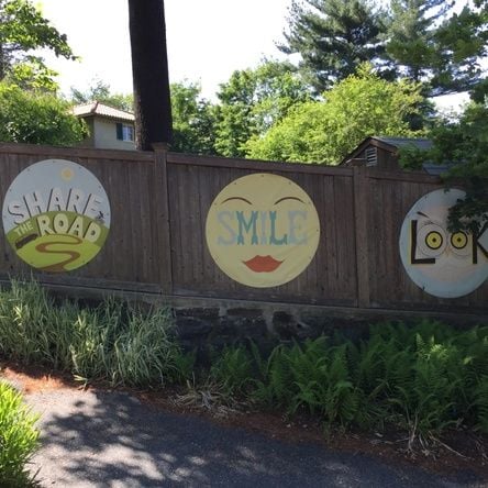
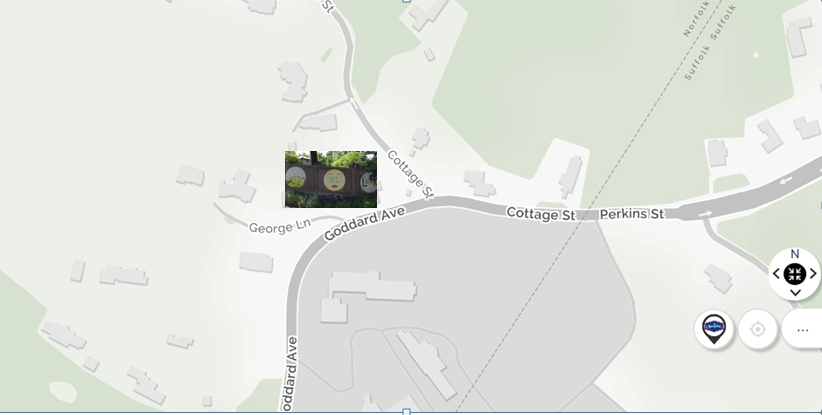
Not only do we have those black and white signs here in Metro Boston, I pass this whimsical one on my commute, with two additional directives, in the People's Republic of Brookline. It's at a fork in the road (at the intersection of Cottage St and Goddard Ave) and faces the oncoming traffic entering the fork (see map below).
It's a somewhat scary fork because as I ride west on Cottage St, upcoming traffic behind me may drive past me as I try to cross over Cottage to Goddard Ave. The slight turn to my left shifts my rearward-mirror view away from the traffic behind me, and often I stop to look and cross. So those signs are welcome.
Both streets are two lane without shoulders and carry a lot of commuter traffic. However there is an asphalt off-road path as seen in the photo. To my advantage also, I ride in the reverse commuter direction, with fewer cars on my side of the road.
02-07-19 | 09:33 AM
#55

aka Tom Reingold


Joined: Jan 2009
Posts: 44,303
Likes: 6,561
From: New York, NY, and High Falls, NY, USA
Bikes: 1962 Rudge Sports, 1971 Raleigh Super Course, 1971 Raleigh Pro Track, 1974 Raleigh International, 1975 Viscount Fixie, 1982 McLean, 1996 Lemond (Ti), 2002 Burley Zydeco tandem
Speaking of streets intersecting themselves, I lived on a street shaped like a 6, and it was impossible to give people directions. I'd like to ask what these designers were thinking, but the trouble is, they weren't.
__________________
Tom Reingold, tom@noglider.com
New York City and High Falls, NY
Blogs: The Experienced Cyclist; noglider's ride blog
�When man invented the bicycle he reached the peak of his attainments.� � Elizabeth West, US author
Please email me rather than PM'ing me. Thanks.
Tom Reingold, tom@noglider.com
New York City and High Falls, NY
Blogs: The Experienced Cyclist; noglider's ride blog
�When man invented the bicycle he reached the peak of his attainments.� � Elizabeth West, US author
Please email me rather than PM'ing me. Thanks.
02-07-19 | 09:41 AM
#56
Banned
Joined: Jul 2010
Posts: 8,543
Likes: 42
From: England / CPH
Bikes: 2010 Cube Acid / 2013 Mango FGSS
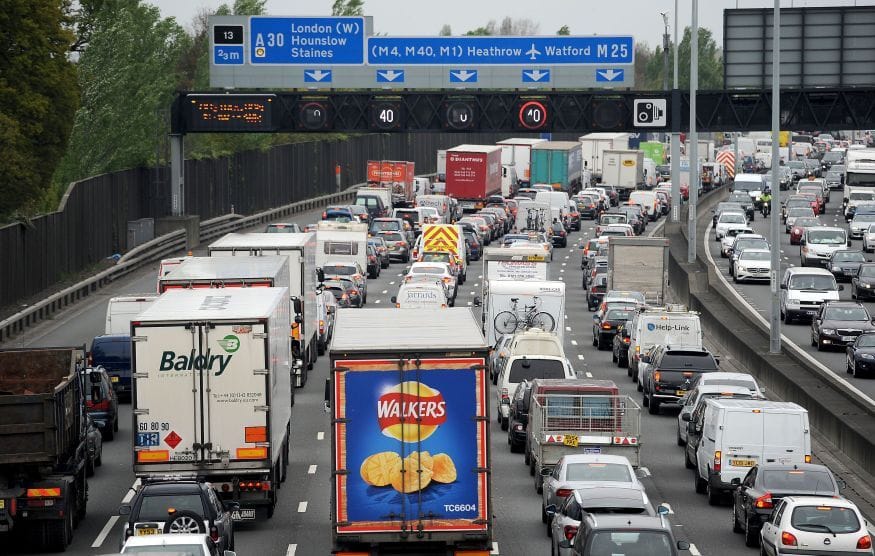
I run into these motorway/highway issues all the time over here.
1. The M25 is an orbital and everyone seems to know every junction by location and usually say, just get on in Woking and get off at South Mimms and don't use the Dartford. Doesn't really matter as it's always jammed. Car's already done the front brakes and a water pump at a little more than 50k due to the stop-n-go.
2. Germany (and most of Europe) never have a North/S/E/W direction, so you better know where all the cities are, so you know if you're going in the right direction.
02-10-19 | 05:20 PM
#57

Park St & Univ Ave, showing the wrong-way bike path. Lots of left hook car-bike crashes here.
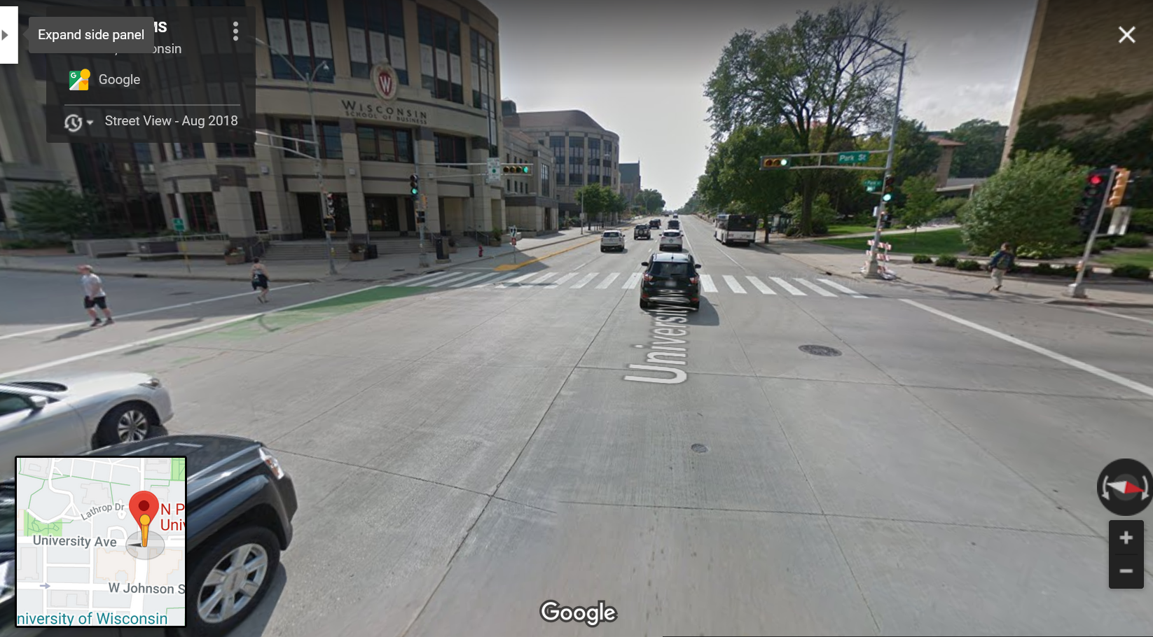
Last edited by duffer1960; 02-10-19 at 05:36 PM.
02-10-19 | 06:35 PM
#58
Senior Member

Joined: Jan 2004
Posts: 6,169
Likes: 1,799
From: Madison, WI USA
I have to admit, first week I lived here, I cut off an eastbound cyclist in the counterflow lane (it's one-way eastbound, so not a "wrong" way). That was 27 years ago; the markings have improved a lot since then, as has the awareness. But as a college town, there's significant population turnover, so always a new crowd to educate. And indeed, it's better than the alternative, which would be close to a mile through campus with no decent eastbound option. There's also a path in the old rail corridor from Monona Bay to Camp Randall that wasn't there 20 years ago, which has taken a lot of the traffic off the counterflow.
02-10-19 | 07:15 PM
#59
Hack
Joined: Sep 2015
Posts: 1,300
Likes: 210
From: Ottawa, Ontario, Canada
Bikes: TrueNorth CX bike, 88 Bianchi Strada (currently Sturmey'd), Yess World Cup race BMX, Pure Cruiser race BMX, RSD Mayor v3 Fatbike
I thought I posted this before....Zamboni crossing on the bike trail. I really have to try to get a better picture, this was on my way to work, was still dark. z
z
z
 02-11-19 | 01:20 PM
#62

Unlisted member
Joined: Dec 2005
Posts: 6,192
Likes: 435
From: Chicagoland
Bikes: Specialized Hardrock
I used to work in an older town that had a number of roads that changed names and directions. Giving people directions there was a challenge.
02-11-19 | 02:01 PM
#63
Senior Member
Joined: Jan 2004
Posts: 6,169
Likes: 1,799
From: Madison, WI USA
We have a few streets where they seemingly arbitrarily change the name somewhere along its course. You could start out at the "cluster-blank" intersection (bad for cars, terrible for bikes, worse for pedestrians) east of downtown, head east on Williamson St, and without "turning" (the road curves as it wraps around the lake), be on five differently named streets. To top off the confusion for visitors, most locals call Williamson "Willy Street".
Adding to the challenge giving directions to visitors are the diagonal streets, the spoke/star pattern of streets around the Square, and the preponderance of one-way streets. Much of downtown is easier to navigate on foot or bike than in a car.
Adding to the challenge giving directions to visitors are the diagonal streets, the spoke/star pattern of streets around the Square, and the preponderance of one-way streets. Much of downtown is easier to navigate on foot or bike than in a car.
Last edited by madpogue; 02-11-19 at 02:06 PM.
02-11-19 | 03:52 PM
#64

Senior Member

Joined: Nov 2014
Posts: 27,576
Likes: 5,476
From: Eugene, Oregon, USA
One should be able to figure that one out.
When I was up in Portland, listening to the morning road reports on the radio, they would read off a list of names of bridges, but I don't think any of the bridge names were marked on either the streets or bridges on any map. I had no idea what they were talking about.
I didn't do a lot of freeway commuting, so I just ignored it.
Here, we have "Beltline Hwy"... it officially has a number designation, but nobody uses the numbers. Actually, it has been called "beltline" since construction, and the numbers are relatively recent. A few years ago, the state officially renamed it to "Randy Pap� Beltline", but I've never heard it referred to as "Randy Pap�"
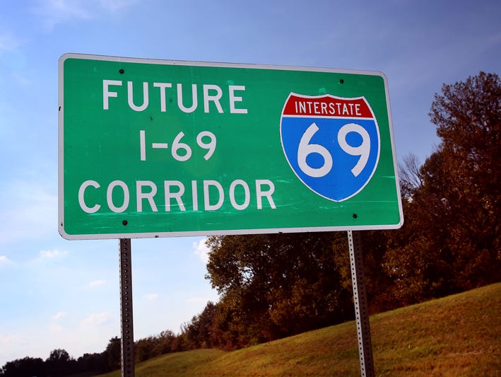
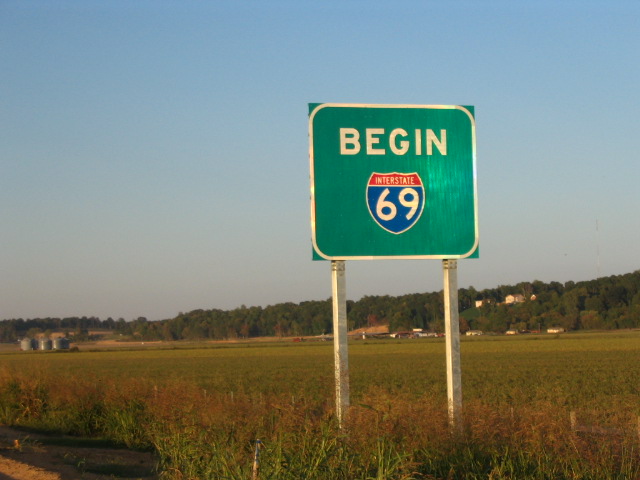
Hmmm... More interesting history of that road. It was built in the 1960's and 70's... and officially designated as Route 69 decades later in 2002. But, the state never actually posted any signs with "69"
ORoads: Oregon Route 69

Eventually the road was renumbered with the far less interesting number, 569.
If you wish to take HWY 69, you may have to head down to Mississippi.
Back here in Eugene/Springfield, we have a Freeway called State HWY 126 in Springfield, and Interstate HWY 105 in Eugene. So, depending on where people are, they'll have two names for the same freeway.
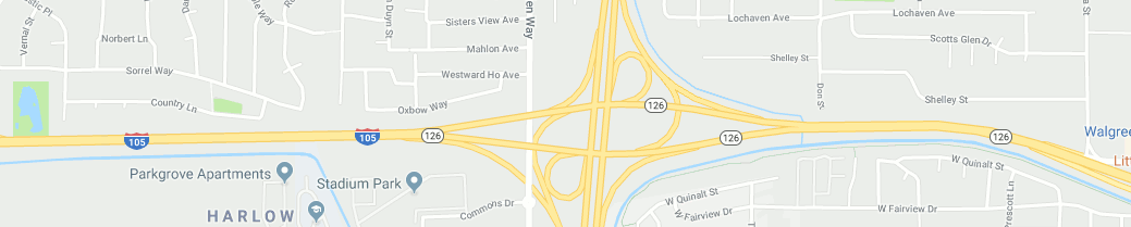
126, of course, is a road/route designation from Florence on the coast to Redmond in centeral Oregon, over 200 miles long. And, technically the segment of Interstate 105 is part of 126.
When I was up in Portland, listening to the morning road reports on the radio, they would read off a list of names of bridges, but I don't think any of the bridge names were marked on either the streets or bridges on any map. I had no idea what they were talking about.
I didn't do a lot of freeway commuting, so I just ignored it.
Here, we have "Beltline Hwy"... it officially has a number designation, but nobody uses the numbers. Actually, it has been called "beltline" since construction, and the numbers are relatively recent. A few years ago, the state officially renamed it to "Randy Pap� Beltline", but I've never heard it referred to as "Randy Pap�"
Hmmm... More interesting history of that road. It was built in the 1960's and 70's... and officially designated as Route 69 decades later in 2002. But, the state never actually posted any signs with "69"
ORoads: Oregon Route 69
Eventually the road was renumbered with the far less interesting number, 569.
If you wish to take HWY 69, you may have to head down to Mississippi.
Back here in Eugene/Springfield, we have a Freeway called State HWY 126 in Springfield, and Interstate HWY 105 in Eugene. So, depending on where people are, they'll have two names for the same freeway.
126, of course, is a road/route designation from Florence on the coast to Redmond in centeral Oregon, over 200 miles long. And, technically the segment of Interstate 105 is part of 126.
02-11-19 | 05:10 PM
#65

Thread Starter
Disco Infiltrator
Joined: May 2013
Posts: 15,345
Likes: 3,542
From: Folsom CA
Bikes: Stormchaser, Paramount, Tilt, Samba tandem
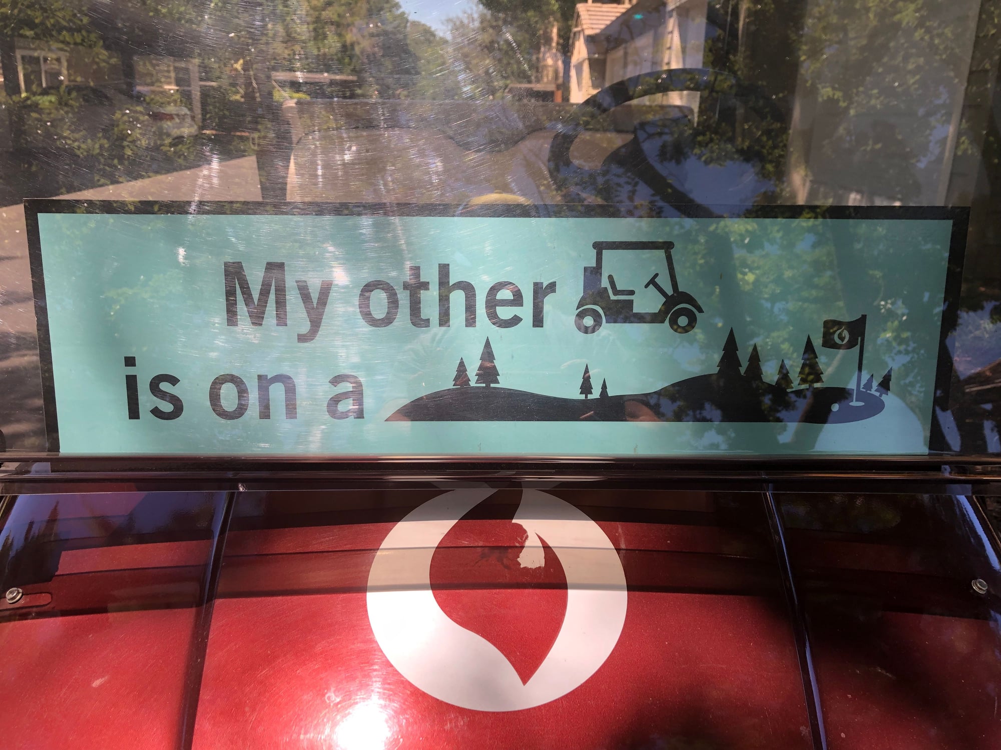
Today while cutting through an apartment complex, saw a golf cart with a sign that said in pictograms, "My other golf cart is on a golf course."
We have some fun road names around here... Fair Oaks Blvd generally follows the north side of the American River in an east-west direction from Sacramento to Fair Oaks, but it veers madly onto the suburban street grid to visit Carmichael. The street name makes 90 degree turns in several places, zig zags through downtown and historic Fair Oaks, then extends straight north for a few miles until it terminates in Citrus Heights.
Another road goes from Sacramento to Folsom along the south of the river, then across the river and north to Auburn. In various places it is called Folsom Road, Folsom Auburn Road, and Auburn Folsom Road
__________________
Genesis 49:16-17
"Well, well!" said Holmes, impatiently. "A good cyclist does not need a high road. The moor is intersected with paths and the moon is at the full."
Genesis 49:16-17
"Well, well!" said Holmes, impatiently. "A good cyclist does not need a high road. The moor is intersected with paths and the moon is at the full."
Last edited by Darth Lefty; 02-11-19 at 05:16 PM.
02-12-19 | 10:25 AM
#66
Senior Member
Joined: Jan 2004
Posts: 6,169
Likes: 1,799
From: Madison, WI USA
I-69 already runs through Michigan and Indiana. There've been plans in the works for years (maybe decades?) to extend it into Kentucky and points south; looks like it's finally a go. I guess I never thought of it as anything but a number until... well... now...
We have scads of highways with multiple numbers. Between here and Portage, all three of Wisconsin's Interstate highways (39, 90, 94) are the same road. Everyone just calls it "the Interstate". There's a segment of our Beltline that serves as FOUR US Federal highways.
I was hoping to post a "that's a welcome sign" sign pic, but... Across the street from my building, they're redeveloping two blocks (god-arful ugly parking ramp gets the wrecking ball soon). They had to take over the rightmost lane of the street, normally a parking/bike lane, for construction ROW. Originally, they put a BUMFL sign on the Jersey barrier that separates the open lane from the temporary pedestrian walk. But look at the wonderful job they've done now:
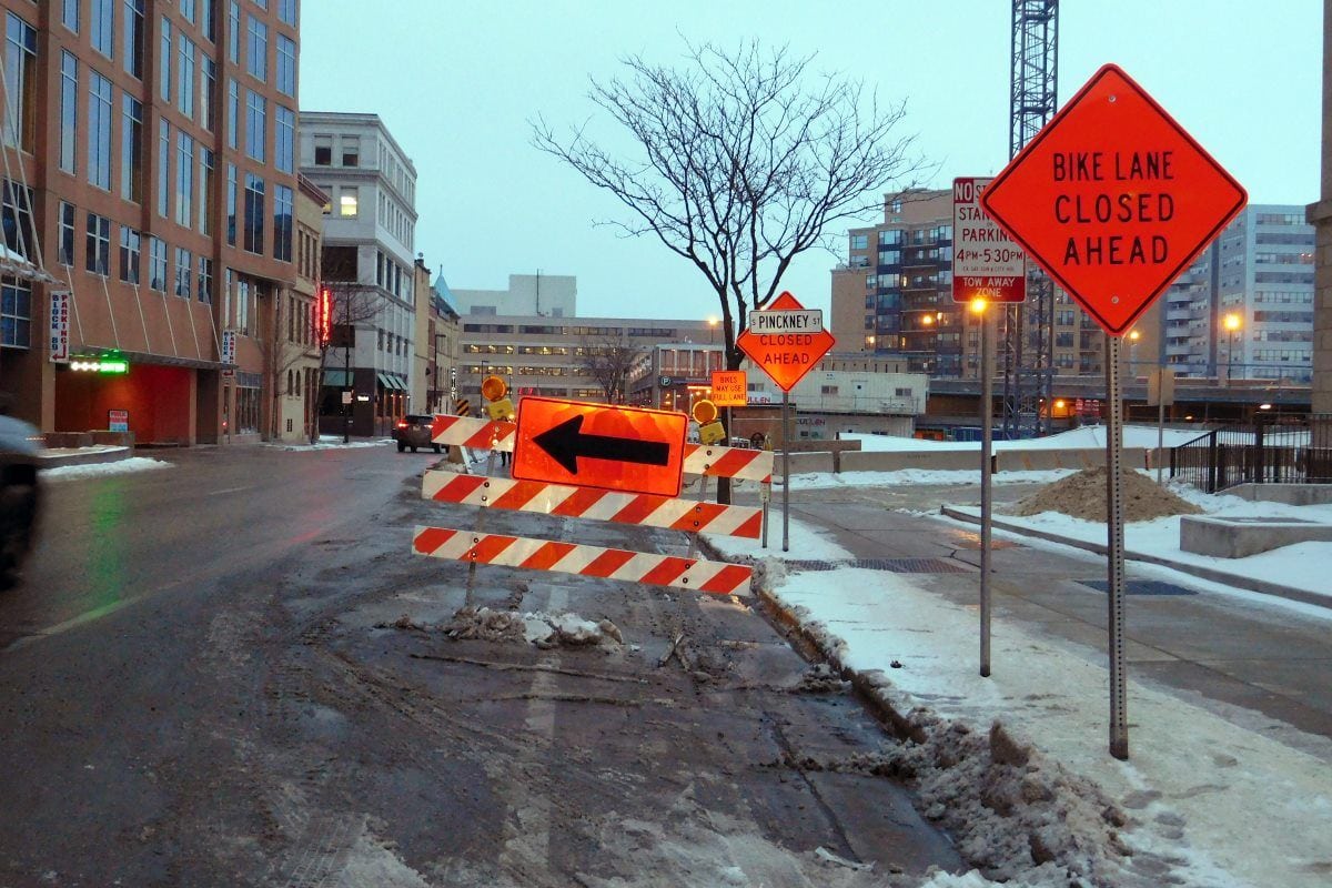
So that's where the lane closure begins, but what happened to the BUMFL? Oh, okay....
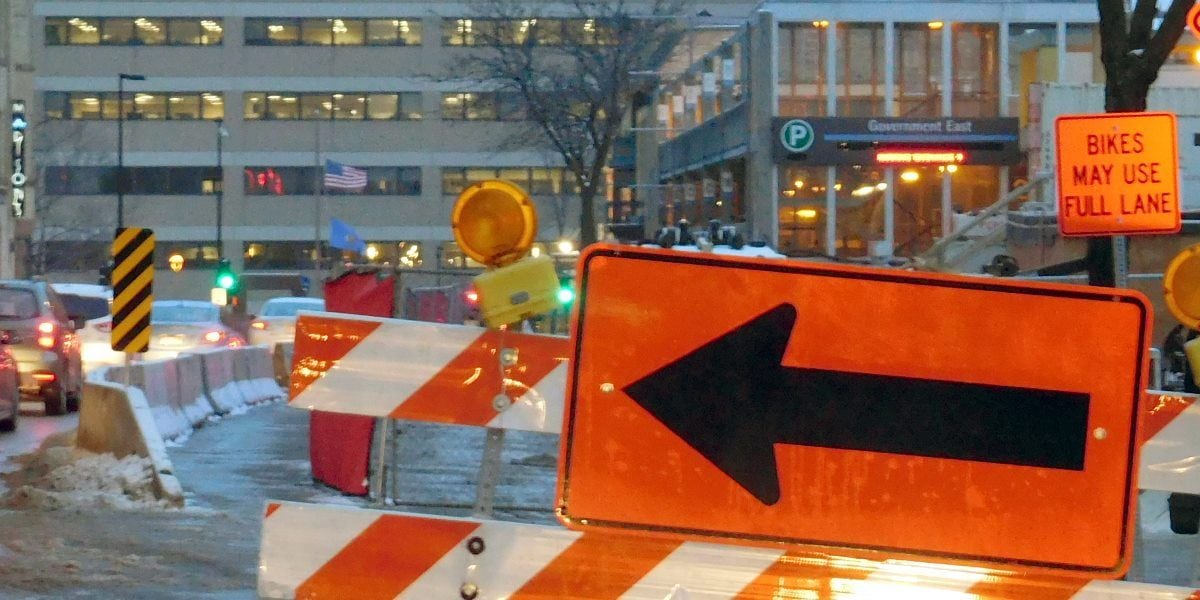
It had been mounted next to (or maybe above?) the yellow/black diagonal stripe sign, right where it MEANS something to car traffic. Who knows why, but they moved it to the curb. Pretty-much behind the signs indicating the closure. Look at the wider shot; do you think rush-hour motorists are really going to notice, let alone heed, that sign?
Fortunately, I have alternate routes.
We have scads of highways with multiple numbers. Between here and Portage, all three of Wisconsin's Interstate highways (39, 90, 94) are the same road. Everyone just calls it "the Interstate". There's a segment of our Beltline that serves as FOUR US Federal highways.
I was hoping to post a "that's a welcome sign" sign pic, but... Across the street from my building, they're redeveloping two blocks (god-arful ugly parking ramp gets the wrecking ball soon). They had to take over the rightmost lane of the street, normally a parking/bike lane, for construction ROW. Originally, they put a BUMFL sign on the Jersey barrier that separates the open lane from the temporary pedestrian walk. But look at the wonderful job they've done now:
So that's where the lane closure begins, but what happened to the BUMFL? Oh, okay....
It had been mounted next to (or maybe above?) the yellow/black diagonal stripe sign, right where it MEANS something to car traffic. Who knows why, but they moved it to the curb. Pretty-much behind the signs indicating the closure. Look at the wider shot; do you think rush-hour motorists are really going to notice, let alone heed, that sign?
Fortunately, I have alternate routes.
02-13-19 | 03:56 PM
#67
Senior Member
Joined: Nov 2014
Posts: 27,576
Likes: 5,476
From: Eugene, Oregon, USA
How many pedestrians in that walkway to the right of the Jersey Barriers?
I think I'd just slip between the Jersey Barriers and the fence. Could they make the walkway 1 foot wider and accommodate both bikes and pedestrians?
What I dislike is when signs are deliberately placed in the middle of bike lanes and road shoulders... causing cyclists to do dangerous merges simply to get around the signs. Especially when the signs cause more interruption to cyclists than the actual construction.
Or, they've left the signs up after all the construction workers have gone home.
02-13-19 | 04:43 PM
#68
Senior Member
Joined: Jan 2004
Posts: 6,169
Likes: 1,799
From: Madison, WI USA
There just wouldn't be space to make it a shared bike/ped "lane". And given the speed of traffic at "rush" hour there, on a bike you're better off in the right lane. It's just that they could have "codified" it better with a sign more visible to the car commuters. Fah, it's a one- or two-year project, minor issue in the grand scheme (the redev is supposed to include a swank "bikestation"), just another "gee whiz" observation.
What I dislike is when signs are deliberately placed in the middle of bike lanes and road shoulders... causing cyclists to do dangerous merges simply to get around the signs.
Last edited by madpogue; 02-13-19 at 04:46 PM.


 08-21-19 | 10:17 PM
#72
Senior Member
Joined: Aug 2014
Posts: 1,898
Likes: 229
From: Bronx, NYC
Bikes: '19 Fuji Gran Fondo 1.5, '72 Peugeot PX10, '71ish Gitane Super Corsa, '78 Fuji Newest, '89 Fuji Ace, '94 Cannondale R600, early '70s LeJeune Pro project


