


Is 1 mile bike path worth 9.2 million?
 02-24-09, 12:32 PM
#51
Senior Member

Join Date: Jun 2007
Location: Minneapolis
Posts: 8,101
Mentioned: 6 Post(s)
Tagged: 0 Thread(s)
Quoted: 52 Post(s)
Likes: 0
Liked 17 Times
in
13 Posts
Though I didn't realize it I happen to look out my office window at a section of the proposed trail too, - apparently the contentious section and I can't say I get why it's so expensive:
"Pricey downtown land, old stone walls and steep, ragged slopes make path construction in the railroad trench a tough task between Washington Avenue and the river.
Building there will require tall retaining walls in some spots and a cut into an existing wall in another. City staffers are negotiating with landowners for property rights."
I'm practically right on top of it. I can feel the vibration in my desk sometimes when the trains go by. So I decided to take some pictures over lunch. Here's one from my desk facing North towards the river. The thing circled in red is a railroad bridge leading over the river to Nicollet Island. That's roughly where the link has to go to connect with the river trail. The tracks on the lower left are where I'm assuming the trail would go (specifically the right set of tracks):
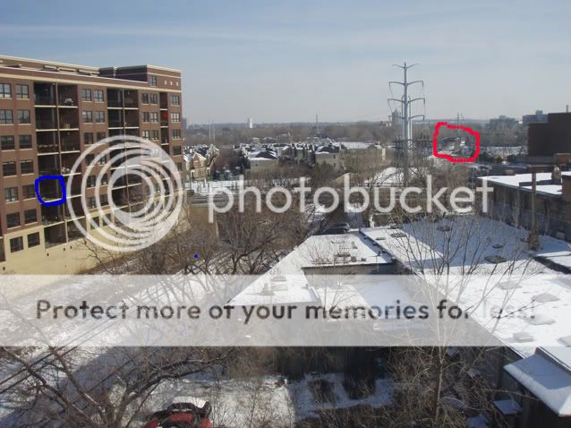
From street level here's one facing South towards Washington Avenue and the Stadium:
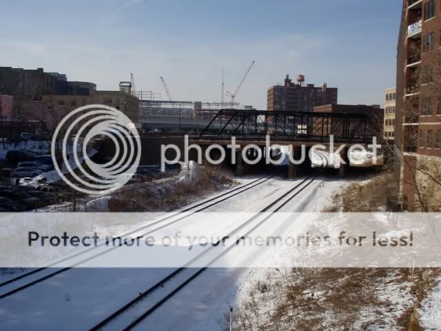
And here's one from Washington Ave North toward the river. I don't think the tracks on the right are being used anymore and I'm guessing that's where the path would go:
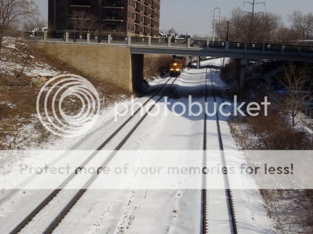
Supposedly this section from where I'm standing to the river will cost over 4 million and that's where the controversy is. Honestly it doesn't look that difficult. An Engineer quoted in the article says he can't verify that this portion really costs 4 million because the project is priced as a whole. Something seems fishy.
Though I'm generally in favor of trails and it would be a shame to force people onto the street for 3 blocks, it is not a hard 3 blocks to be on the streets (assuming the trail would at least cross Washington). I ride it daily.
"Pricey downtown land, old stone walls and steep, ragged slopes make path construction in the railroad trench a tough task between Washington Avenue and the river.
Building there will require tall retaining walls in some spots and a cut into an existing wall in another. City staffers are negotiating with landowners for property rights."
I'm practically right on top of it. I can feel the vibration in my desk sometimes when the trains go by. So I decided to take some pictures over lunch. Here's one from my desk facing North towards the river. The thing circled in red is a railroad bridge leading over the river to Nicollet Island. That's roughly where the link has to go to connect with the river trail. The tracks on the lower left are where I'm assuming the trail would go (specifically the right set of tracks):
From street level here's one facing South towards Washington Avenue and the Stadium:
And here's one from Washington Ave North toward the river. I don't think the tracks on the right are being used anymore and I'm guessing that's where the path would go:
Supposedly this section from where I'm standing to the river will cost over 4 million and that's where the controversy is. Honestly it doesn't look that difficult. An Engineer quoted in the article says he can't verify that this portion really costs 4 million because the project is priced as a whole. Something seems fishy.
Though I'm generally in favor of trails and it would be a shame to force people onto the street for 3 blocks, it is not a hard 3 blocks to be on the streets (assuming the trail would at least cross Washington). I ride it daily.
Last edited by tjspiel; 02-24-09 at 03:48 PM.
 02-24-09, 12:53 PM
#52

Sensible shoes.
Join Date: Aug 2005
Location: St. Paul,MN
Posts: 8,798
Bikes: A few.
Mentioned: 0 Post(s)
Tagged: 0 Thread(s)
Quoted: 4 Post(s)
Likes: 0
Liked 0 Times
in
0 Posts
Public works projects often have other projects residing under their umbrella.
02-24-09, 12:55 PM
#53
genec

Join Date: Sep 2004
Location: West Coast
Posts: 27,079
Bikes: custom built, sannino, beachbike, giant trance x2
Mentioned: 86 Post(s)
Tagged: 0 Thread(s)
Quoted: 13658 Post(s)
Liked 4,532 Times
in
3,158 Posts
I've said it before and I'll say it again. Close the closest road that can serve cyclists for this route. Make it no motor vehicles and open it only to bikes.
Then see if folks whine about the cost to add in a new street for cars.
Then see if folks whine about the cost to add in a new street for cars.
02-24-09, 01:09 PM
#54
Senior Member
Join Date: Jun 2007
Location: Minneapolis
Posts: 8,101
Mentioned: 6 Post(s)
Tagged: 0 Thread(s)
Quoted: 52 Post(s)
Likes: 0
Liked 17 Times
in
13 Posts
I understand that you've got to buy the property and the property in the area is more valuable than it was a few years ago. However, I don't know how much you can really do with a sliver of property next to a railroad trench or the trench itself. Nobody's gonna stick a McDonalds' down there.
02-24-09, 01:46 PM
#55
genec
Join Date: Sep 2004
Location: West Coast
Posts: 27,079
Bikes: custom built, sannino, beachbike, giant trance x2
Mentioned: 86 Post(s)
Tagged: 0 Thread(s)
Quoted: 13658 Post(s)
Liked 4,532 Times
in
3,158 Posts
I don't have a problem with the money if it actually costs that much, but I suspect as Cast Iron implies that there's something else buried in the cost of this project or there is some gouging going on.
I understand that you've got to buy the property and the property in the area is more valuable than it was a few years ago. However, I don't know how much you can really do with a sliver of property next to a railroad trench or the trench itself. Nobody's gonna stick a McDonalds' down there.
I understand that you've got to buy the property and the property in the area is more valuable than it was a few years ago. However, I don't know how much you can really do with a sliver of property next to a railroad trench or the trench itself. Nobody's gonna stick a McDonalds' down there.
02-24-09, 02:05 PM
#56
Sensible shoes.
Join Date: Aug 2005
Location: St. Paul,MN
Posts: 8,798
Bikes: A few.
Mentioned: 0 Post(s)
Tagged: 0 Thread(s)
Quoted: 4 Post(s)
Likes: 0
Liked 0 Times
in
0 Posts
RR right of ways are a special circle of hell in these terms. They are governed by some obtuse and antiquated federal laws. And remember, once a railway disposes of a line, it's nearly impossible for them to get it back. Combine that with their growing demand and any infrastructure or hazardous waste clean-up needs that must be upgraded to meet modern codes and it gets expensive even by government standards. I'd love to see the cost to build one lane mile of freeway in that exact same stretch of Earth. The engineering standards are night and day.
02-24-09, 02:40 PM
#57
Senior Member
Join Date: Jun 2007
Location: Minneapolis
Posts: 8,101
Mentioned: 6 Post(s)
Tagged: 0 Thread(s)
Quoted: 52 Post(s)
Likes: 0
Liked 17 Times
in
13 Posts
RR right of ways are a special circle of hell in these terms. They are governed by some obtuse and antiquated federal laws. And remember, once a railway disposes of a line, it's nearly impossible for them to get it back. Combine that with their growing demand and any infrastructure or hazardous waste clean-up needs that must be upgraded to meet modern codes and it gets expensive even by government standards. I'd love to see the cost to build one lane mile of freeway in that exact same stretch of Earth. The engineering standards are night and day.
It just seems bizarre that the choices are to leave the land un-utilized or spend 4 million dollars to put down a 3 block long stretch of pavement a few feet wide.
02-24-09, 03:44 PM
#58
Senior Member
Join Date: Jun 2008
Location: eastern Massachusetts
Posts: 994
Bikes: Rans V-Rex
Mentioned: 0 Post(s)
Tagged: 0 Thread(s)
Quoted: 0 Post(s)
Likes: 0
Liked 0 Times
in
0 Posts
If society can somehow afford over $6 billion for a mile of roadway, then yes, that 1 mile bike path is worth it.
I refer, of course, to the 3.5 mile long Big Dig in Boston, with a cost of $22 billion.
I refer, of course, to the 3.5 mile long Big Dig in Boston, with a cost of $22 billion.
02-25-09, 01:30 AM
#59
Senior Member

Join Date: Sep 2006
Location: Crystal MN
Posts: 2,147
Mentioned: 0 Post(s)
Tagged: 0 Thread(s)
Quoted: 0 Post(s)
Likes: 0
Liked 0 Times
in
0 Posts
https://www.ci.minneapolis.mn.us/publ...ocationmap.gif
Now keep in mind the one line continues that is not an entrance.
The one with a u turn thing is the entrance and is really hard to find.
I came from northbound River parkway and had to go through the downtown to get to the Cedar Trail. Yes the missing link. (although they had the parkway closed due to I35w bridge construction. ) I even looked at their web site to make sure I could use it. After stumbling onto Washington I got honked at and buzzed within the first minute. Getting to the trail from the east is really frikin hard. For people who don't know the one way streets not to mention the street corner I am headed to has all sorts of physical barriers.
It took me 45 mins to find it and I had the frikin map. No signs or nothing that I could see. I had to pass down the street only to come back up a few times. The U entrance is the only entrance for a long distance.
I think you have to look at the history of this small corner.
They tore up a huge chunk of land (removed a park) for HWY 394. Didn't put the bike path in then.
They are adding 2009 a commuter rail station here which goes all the way to Big Lake.
They are building a 574 million dollar stadium. Didn't put the bike path in the stadium plans.
Sure 9.2 million is alot, but look above bicycling is getting left out over 9.2 million dollars which would then complete the trail providing a 25 mile circle in the heart of Minneapolis. I know because I did it. I sure hope when I try it the next time I can do the circle route. I was surprised to hear all the negative comments. Considering the billions they spent on this little corner.
Last edited by wheel; 02-25-09 at 01:37 AM.
02-25-09, 02:27 AM
#60
Senior Member
Join Date: Jun 2007
Location: Minneapolis
Posts: 8,101
Mentioned: 6 Post(s)
Tagged: 0 Thread(s)
Quoted: 52 Post(s)
Likes: 0
Liked 17 Times
in
13 Posts
https://www.ci.minneapolis.mn.us/publ...ocationmap.gif
Now keep in mind the one line continues that is not an entrance.
The one with a u turn thing is the entrance and is really hard to find.
I came from northbound River parkway and had to go through the downtown to get to the Cedar Trail. Yes the missing link. (although they had the parkway closed due to I35w bridge construction. ) I even looked at their web site to make sure I could use it. After stumbling onto Washington I got honked at and buzzed within the first minute. Getting to the trail from the east is really frikin hard. For people who don't know the one way streets not to mention the street corner I am headed to has all sorts of physical barriers.
It took me 45 mins to find it and I had the frikin map. No signs or nothing that I could see. I had to pass down the street only to come back up a few times. The U entrance is the only entrance for a long distance.
I think you have to look at the history of this small corner.
They tore up a huge chunk of land (removed a park) for HWY 394. Didn't put the bike path in then.
They are adding 2009 a commuter rail station here which goes all the way to Big Lake.
They are building a 574 million dollar stadium. Didn't put the bike path in the stadium plans.
Sure 9.2 million is alot, but look above bicycling is getting left out over 9.2 million dollars which would then complete the trail providing a 25 mile circle in the heart of Minneapolis. I know because I did it. I sure hope when I try it the next time I can do the circle route. I was surprised to hear all the negative comments. Considering the billions they spent on this little corner.
Now keep in mind the one line continues that is not an entrance.
The one with a u turn thing is the entrance and is really hard to find.
I came from northbound River parkway and had to go through the downtown to get to the Cedar Trail. Yes the missing link. (although they had the parkway closed due to I35w bridge construction. ) I even looked at their web site to make sure I could use it. After stumbling onto Washington I got honked at and buzzed within the first minute. Getting to the trail from the east is really frikin hard. For people who don't know the one way streets not to mention the street corner I am headed to has all sorts of physical barriers.
It took me 45 mins to find it and I had the frikin map. No signs or nothing that I could see. I had to pass down the street only to come back up a few times. The U entrance is the only entrance for a long distance.
I think you have to look at the history of this small corner.
They tore up a huge chunk of land (removed a park) for HWY 394. Didn't put the bike path in then.
They are adding 2009 a commuter rail station here which goes all the way to Big Lake.
They are building a 574 million dollar stadium. Didn't put the bike path in the stadium plans.
Sure 9.2 million is alot, but look above bicycling is getting left out over 9.2 million dollars which would then complete the trail providing a 25 mile circle in the heart of Minneapolis. I know because I did it. I sure hope when I try it the next time I can do the circle route. I was surprised to hear all the negative comments. Considering the billions they spent on this little corner.
I agree the link should be finished but I also think it's reasonable to ask why it costs 9.2 million and why approximately half of that is needed for the last 3 blocks to the river when that appears to be about the easiest part of the link. I'll have to check tomorrow when I ride in how the actual connection to the river parkway could be made. My guess is that will require some money.
Apparently the original city plan put cyclists on the street for those last 3 blocks which honestly isn't all that bad. It might actually be preferable if they came up with something other than just paint to separate the bikes from the cars. It could be beneficial to the city and the cyclists if it allowed easy access to some of the coffee shops, bars, and restaurants that are nearby. Sometimes I think our cycling infrastructure is too separate from everything else. That's great for riding, but makes it harder when you actually want to get someplace.
If the link is made completely off-street then getting anywhere downtown except for things right on the river (which isn't much) won't be all that easy.
02-25-09, 05:54 AM
#61
Senior Member
Join Date: Sep 2006
Location: Crystal MN
Posts: 2,147
Mentioned: 0 Post(s)
Tagged: 0 Thread(s)
Quoted: 0 Post(s)
Likes: 0
Liked 0 Times
in
0 Posts
I too had a very difficult time finding the current entrance even after having a couple of people explain to me where it was.
I agree the link should be finished but I also think it's reasonable to ask why it costs 9.2 million and why approximately half of that is needed for the last 3 blocks to the river when that appears to be about the easiest part of the link. I'll have to check tomorrow when I ride in how the actual connection to the river parkway could be made. My guess is that will require some money.
Apparently the original city plan put cyclists on the street for those last 3 blocks which honestly isn't all that bad. It might actually be preferable if they came up with something other than just paint to separate the bikes from the cars. It could be beneficial to the city and the cyclists if it allowed easy access to some of the coffee shops, bars, and restaurants that are nearby. Sometimes I think our cycling infrastructure is too separate from everything else. That's great for riding, but makes it harder when you actually want to get someplace.
If the link is made completely off-street then getting anywhere downtown except for things right on the river (which isn't much) won't be all that easy.
https://www.interstate-guide.com/i-394_mn.html
I-394 cost 500 million for 9.5 miles or 52 million a mile. Add another 10 million for hot lanes.
I hope they make it completely off street. If you want to get too downtown you will as the location of the trail is already really hard to get to and out of the way. When you take in the account of the area ,the current entrance location and or future locations.
14 years and billions spent on this corner I say build it.
02-25-09, 09:13 AM
#62
Senior Member
Join Date: Jun 2007
Location: Minneapolis
Posts: 8,101
Mentioned: 6 Post(s)
Tagged: 0 Thread(s)
Quoted: 52 Post(s)
Likes: 0
Liked 17 Times
in
13 Posts
The Cedar Lake Trail is America's first bike freeway. It is a rail trail located on the west side of Minneapolis, Minnesota and was inaugurated on February 17, 1995.
https://www.interstate-guide.com/i-394_mn.html
I-394 cost 500 million for 9.5 miles or 52 million a mile. Add another 10 million for hot lanes.
I hope they make it completely off street. If you want to get too downtown you will as the location of the trail is already really hard to get to and out of the way. When you take in the account of the area ,the current entrance location and or future locations.
14 years and billions spent on this corner I say build it.
As taxpayers we should not be OK with getting ripped off just because completing the link is highly desirable or because we spent an exorbitant amount of money on a freeway. If the real cost is 9.x million, then let's suck it up and build it. But if the budget was padded with money for something else or someone is just using this as an opportunity to line their pocket, then we need to put the brakes on.
02-25-09, 09:39 AM
#63
ride for a change
Join Date: Nov 2006
Location: Minneapolis, MN
Posts: 2,221
Bikes: Surly Cross-check & Moonlander, Pivot Mach 429, Ted Wojcik Sof-Trac, Ridley Orion. Santa Cruz Stigmata
Mentioned: 0 Post(s)
Tagged: 0 Thread(s)
Quoted: 0 Post(s)
Likes: 0
Liked 1 Time
in
1 Post
The current downtown entrance is really a joke. It's very hard to get to, and hard to explain to anyone how to get to it. I have to cut under the A ramp, take the sidewalk over the 394 bridge against traffic for a block just to get there, it saves me an extra 6 blocks in rush hour traffic. I endure it but I don't like it.
Thanks for posting the map. I have already expressed by support for building the trail, but I hope in the plan that there are a few more entrances/access points along the stretch. It's not clear from the maps I've seen. I think it will serve downtown businesses and downtown cyclists far better if they can find one or two.
Thanks for posting the map. I have already expressed by support for building the trail, but I hope in the plan that there are a few more entrances/access points along the stretch. It's not clear from the maps I've seen. I think it will serve downtown businesses and downtown cyclists far better if they can find one or two.
02-25-09, 10:10 AM
#64
Senior Member
Join Date: Jun 2007
Location: Minneapolis
Posts: 8,101
Mentioned: 6 Post(s)
Tagged: 0 Thread(s)
Quoted: 52 Post(s)
Likes: 0
Liked 17 Times
in
13 Posts
The current downtown entrance is really a joke. It's very hard to get to, and hard to explain to anyone how to get to it. I have to cut under the A ramp, take the sidewalk over the 394 bridge against traffic for a block just to get there, it saves me an extra 6 blocks in rush hour traffic. I endure it but I don't like it.
Thanks for posting the map. I have already expressed by support for building the trail, but I hope in the plan that there are a few more entrances/access points along the stretch. It's not clear from the maps I've seen. I think it will serve downtown businesses and downtown cyclists far better if they can find one or two.
Thanks for posting the map. I have already expressed by support for building the trail, but I hope in the plan that there are a few more entrances/access points along the stretch. It's not clear from the maps I've seen. I think it will serve downtown businesses and downtown cyclists far better if they can find one or two.
11th Street isn't in the greatest shape and getting onto it from Hennepin means cutting across the bus lane but that's part of the joy of having bike lanes running down the middle of the street.
It's not very direct but fairly low stress.
02-25-09, 09:14 PM
#65
Senior Member
Join Date: Sep 2006
Location: Crystal MN
Posts: 2,147
Mentioned: 0 Post(s)
Tagged: 0 Thread(s)
Quoted: 0 Post(s)
Likes: 0
Liked 0 Times
in
0 Posts
What I tell people looking for the trail is to take Hennepin South and hang a right at 11th Street. Stay on 11th until you see Lee's Liquor Lounge then look for a trail heading downhill on the right side of the street.
11th Street isn't in the greatest shape and getting onto it from Hennepin means cutting across the bus lane but that's part of the joy of having bike lanes running down the middle of the street.
It's not very direct but fairly low stress.
11th Street isn't in the greatest shape and getting onto it from Hennepin means cutting across the bus lane but that's part of the joy of having bike lanes running down the middle of the street.
It's not very direct but fairly low stress.
02-26-09, 11:20 AM
#66
Member

Join Date: Apr 2008
Location: Minneapolis, MN
Posts: 26
Bikes: 08 Bianchi San Jose, 05 Marin Muirwoods
Mentioned: 0 Post(s)
Tagged: 0 Thread(s)
Quoted: 0 Post(s)
Likes: 0
Liked 0 Times
in
0 Posts
Where's your office/workplace? If you check the map again, you'll see there is a proposed extension of the LRT trail (might be just a bike lane) to the end of the line. I don't know if that'll help you or not. I also work on the other side of town from the end of LRT trail but I'm only a couple blocks from the river. From the LRT trail I can turn right (N) onto a bike lane and follow it to the river. From there I can catch a MUP or ride the relatively quiet river road NW toward my office in the warehouse district. It might be a few blocks out of your way but probably more pleasant.
Overall my commute is pretty nice.
Overall my commute is pretty nice.
From the map, it looks like the only change will be painting a line down 3rd street, which is the ultimate bike infrastructure cop-out, IMO. The city needs to provide a meaningful route through the heart of downtown if they want to really promote commuting. Dodging downtown traffic seems to be one of the biggest fears of potential commuters. Some sort of physically segregated lane would do wonders to resolve this.
The proposed new stretch of path is fine by me, but still seems recreational.
