


DCR: Wahoo ELEMNT BOLT In-Depth Review
 03-14-17 | 09:59 AM
#1
Thread Starter
Senior Member
Joined: Mar 2010
Posts: 23,208
Likes: 10,653
From: Seattle, WA
 03-14-17 | 10:56 AM
#2
Randomhead
Joined: Aug 2008
Posts: 25,930
Likes: 4,825
From: Happy Valley, Pennsylvania
that looks good. I saw the review of the Elment, and it didn't do what I needed, so just forgot about it. Now it turns out that it does navigation, so it's a lot more interesting. Not sure I want to control a device with my phone. The most important question is if it recharges while navigating. Ray didn't even run the battery all the way down, so I guess that's not important to him
03-15-17 | 09:38 AM
#3
Senior Member
Joined: Jun 2008
Posts: 77
Likes: 0
From: Latham NY
Bikes: 03 Marin Bear Valley, 1999 GT ZR2000, Raleigh M80(converted to single speed), 2017 Masi Gran Corsa disc.
During the winter I started back on the trainer in the basement. I didn't have a wireless spedo on the bike and wanted to start training with cadence. After a brief internet search I found the Wahoo sensors, the prices weren't stupid high and I could use my phone for readouts while on the trainer, no big deal. Well then I purchased a new bike, then Wahoo announced the Bolt, and I already have the sensors, and I don't have a computer for the brand new bike. So, why not? I ordered one yesterday.
03-16-17 | 04:43 PM
#4
Senior Member

Joined: Sep 2014
Posts: 1,693
Likes: 298
From: Northeastern MA, USA
Bikes: Garmin/Tacx Bike Smart
This looks like a winner, and I ordered one today. The Garmin I have will go on eBay. I have never been able to upload an activity, and Garmin finally admitted that it's a known bug, but they have no date for a fix. The Bolt is expected to ship on 3/22.
Essentially an Element in a smaller package.
Essentially an Element in a smaller package.
03-16-17 | 04:51 PM
#5
Senior Member


Joined: Sep 2007
Posts: 15,315
Likes: 1,781
From: Far beyond the pale horizon.
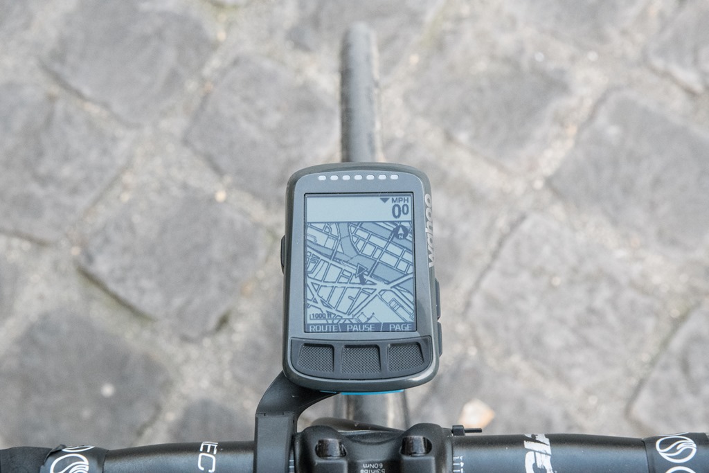
Apparently, it does "course point" navigation like the Garmin 500/510/520 do.
The 520 can also display maps (nothing more than display them) like the Elmnt/Bolt can but the size of the maps that can be installed on the 520 is small The Elmnt/Bolt have world-wide maps (who knows how frequently they get updated).
The Elmnt/Bolt itself can't calculate routes (turn instructions). It needs a cellphone and, possibly, cell/internet access.
03-17-17 | 09:43 AM
#7
Senior Member
Joined: Sep 2007
Posts: 15,315
Likes: 1,781
From: Far beyond the pale horizon.
It might only need 8 GB (so "cheap").
The Garmins with maps (800 and later) let you do interesting things with maps (maps with overlays) and with courses (you can display courses without using them for navigation).
The Elmnt/Bolt competes with the Edge 520.
03-17-17 | 10:19 AM
#8
Thread Starter
Senior Member
Joined: Mar 2010
Posts: 23,208
Likes: 10,653
From: Seattle, WA
Apparently it can't show street names on the map. If you miss a turn while navigating, it can't route you back to where you need to be. And while it has maps, there's no touch screen. Caveat emptor.
03-17-17 | 11:49 AM
#9
Randomhead
Joined: Aug 2008
Posts: 25,930
Likes: 4,825
From: Happy Valley, Pennsylvania
03-17-17 | 12:09 PM
#10
Senior Member
Joined: Sep 2007
Posts: 15,315
Likes: 1,781
From: Far beyond the pale horizon.
I've followed cuesheets by using the street names displayed by the 800 (sometimes, easier than figuring out where the street sign might be). I don't think the 520 displays street names.
Elmnt/Bolt don't do any routing. They just display the routing downloaded to them.
The "routing back" when going off-course very isn't useful on the 800. The 800 abandons the course and creates a new route to the end point, which is not something that people typically want to do (it isn't even what people expect it to do). It looks like the 1000 might reroute you back to the nearest point on the course (which is what people tend to expect).
I don't find the rerouting necessary. If go off course, I usually know about it fairly quickly and it's easy enough just to ride to the purple line.
03-17-17 | 12:42 PM
#11
Senior Member
Joined: Sep 2007
Posts: 15,315
Likes: 1,781
From: Far beyond the pale horizon.
"course points" work but they are somewhat too precise (they are very position dependent). By default, on the Garmins, they show up at the turns on the course when they'd be more useful to show up before the turns. Ridewithgps gives subscribers an option to move the course points earlier in the track/course. Bikeroutetoaster gives you the option to copy the course points earlier (so, each turn has two of them).
Maybe, the Elmnt/Bolt handle the course points better than the Garmins do.
It's possible that the Elmnt/Bolt are doing something that are kind-of like course points but Wahoo's own thing.
The Garmins with maps also provide "turn guidance" (big white arrows) in addition to the course points (you can use both together or one or the other separately). With these, you get big white arrows showing up about 0.1 miles before the turn. These are easier to see than course points and much less position dependent.
One benefit of the "turn guidance" is that it will work with any gpx track file.
Not too many things support "course points", which are an optional feature of tcx files. Ridewithgps does.
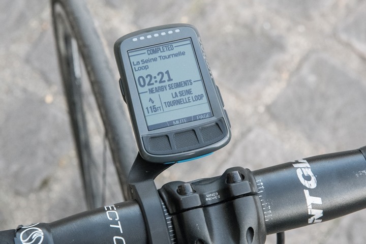
dcrainmaker says you get turn-instructions on the Bolt from course downloaded from ridewithgps.
The turn instructions he showed in the photos have labels that are longer than the labels of the course points ridewithgps writes to its tcx files. I don't know what's going on there. Maybe, one uses file exported by the "gpx route" option.
===================
https://www.dcrainmaker.com/2016/06/...oo-elemnt.html
* The navigation the Bolt has is the same that was added to the Elmnt in June 2016.
* "It’s basically only going to route you from Point A to Point B, using the directions pre-canned by RideWithGPS." (Sounds like course points or waypoints.)
* In the feature comparison table, dcrainmaker has "yes" for "ROUTABLE/VISUAL MAPS (LIKE CAR GPS)" for the Elmnt/Bolt but that appears to be wrong (based on dcrainmaker's description of the navigation on the Elmnt.
dcrainmaker seems to think adding maps to the Garmins is difficult. After doing it once, it's not that hard.
===================
No, probably not.
The 800/810/1000 have the same navigation features of the 520/510/500 but add "turn guidance" (big white arrows).
If you don't like the "turn guidance" (big white arrows), you don't have to use it.
Maps work better on the 800/810/1000 than they do on the 520 and the screens are bigger than on the 520.
The 520 sort-of supports maps (it's kind of a hack) but the size of the maps that can be installed on it is very small (making regularly dealing with maps for it too fussy).
Last edited by njkayaker; 03-17-17 at 01:28 PM.
03-18-17 | 09:53 PM
#13
Senior Member
Joined: Sep 2007
Posts: 15,315
Likes: 1,781
From: Far beyond the pale horizon.
03-24-17 | 10:29 PM
#14


Ride it like you stole it
Joined: Nov 2005
Posts: 4,996
Likes: 21
From: Union County, NC
Bikes: 2012 Cannondale EVO Ultegra Di2, Pedal Force Aeroblade, Rue Tandem
This might end up being the bike computer that finally moves me away from my Edge 810. I still want ot see if there is a 1000 successor debuted at Sea Otter before making a decision.
__________________
"Never use your face as a brake pad" - Jake Watson
The Reloutionaries @ Shapeways
"Never use your face as a brake pad" - Jake Watson
The Reloutionaries @ Shapeways

Thread
Thread Starter
Forum
Replies
Last Post
johngwheeler
Road Cycling
22
03-02-18 09:01 PM
C_Heath
Electronics, Lighting, & Gadgets
9
12-24-17 09:44 PM
