


GPS for touring
 09-14-25 | 02:16 PM
#26
Thread Starter
Junior Member

Joined: Oct 2015
Posts: 96
Likes: 18
From: France C�vennes
Bikes: Santos travelmaster2.8 ; Brompton titanium ; R&M Load speed
For bike touring I use the link in my previous post. I select Garmin Openfiets Latin 1. For some reason my notes say I use Ascii, but I do not see that as an option. Instead of typing a lot, I laid out an area to download, this covers most of Wisc and part of Minn, down to include Chicago, Ill. Then I took a screenshot on my computer.

I typed in test as a name. When I have multiple maps on my GPS SD card, the name I type is the name of the map if my memory is correct. (I have not done this for months, I might have that wrong.) I click extract. Then it sends me an e-mail telling me when my map is ready. When it is, I put the IMG file onto my GPS. I think this website is limited to half a GB per map, I might have too much area on that map in the example, if that happens, make it a bit smaller.
They have other formats, I have not played too much with various formats, I found I liked this format for biking so that is what I have used for years.
Since the GPS I use takes AA batteries and I saw some Etrex models do too, you can either buy disposable or NiMH or Li Ion rechargeable. I have not bought disposable AA or AAA for over a decade and a half. I use Ladda 2450 NiMH rechargable from Ikea or if not near an Ikea, Eneloop batteries. I mentioned in my previous post I can charge them in my GPS, but I think you can't with the Etrex.
I mentioned you can also buy AA or AAA that are Lithium Ion. I recently bought some of them too, have not tried them on a bike yet. They put out a constant 1.5v until they are empty. So, they very suddenly will be empty and you need to swap batteries. Thus, they might not be the best choice for bike touring as you may look at your GPS and suddenly realize it is off, time to pull over and swap batteries, which could be an inconvenient time. But if you want to try those, they can be charged by plugging a USB-C or Micro USB cable into the battery. You might find some of these on amazon if you are interested. I am using these at home on some electronics that work best at 1.5v, like my kitchen scale, etc.
Over the years I have bought three or four different AA/AAA chargers that run on a USB cable. The Powerchimp I used on my 2019 tour is below:

In the above example, three batteries are still charging, one is full. Same device below not plugged in. I am charging AAA in this example, can also charge AA.

Or a different AA charger. Photo below has the Eneloop chargers that can charge two AA and a camera batter charger, not sure if these Eneloop chargers are still made, photo is nine years old so the chargers are older than that. I was charging up two sets of batteries from a wall charger in Iceland.

I have a dynohub on my front wheel. I use a Cycle2Charge to convert my electric output from that to USB. I put that power into a powerbank when I am rolling with my lights off. (My taillight flasher is battery powered, not powered from dynohub.)
I suspect you can't buy Cycle2Charge chargers any more, they are made and shipped from Germany and I think nobody in Germany is shipping stuff to USA due to the tariff uncertainty. That said, I used to use a Sinewave Revolution, they are still available because that company is in USA. And there are several other options to convert dyhohub output to USB power.
I use a Voltaic powerbank, I can charge it and discharge it simultaneously. In other words, I can plug my dynohub charger in to charge it while I am using the powerbank to charge other devices like my phone.
But kayaking or canoeing or backpacking, I bring a lot of batteries, do not try to charge them during a trip. I brought a solar panel on one trip but decided that the batteries were lighter than the panel was for the amount of power that I actually got out of the panel.
On my last tour a year ago, described here, there is a section on electrics. Describes some of this in more detail.
Bike Tour near Lake Ontario and part of Erie Canal - June 2024
For other activities I usually use topo maps from this site:
https://www.gmaptool.eu/en/content/u...-topo-routable
Your last comment, your Son did not provide enough power, what did you put the power from the Son into?
I am somewhat obsessive to make sure I am not wasting power. When the visibility is good enough to have my dyno powered lights off, I am charging my powerbank (Voltaic). But, dynohub output is only giving me roughly 2 watts on average into my power bank when you factor in hills, photo stops along the way, etc. On a hilly segment, cut that in half. And my taillight flashers are powered by AAA. Thus, most of the time my hub is only used to charge batteries.
My 2019 tour, I did not even put dyno powered lights on my bike, the dynohub was only used to charge batteries. If I needed a headlamp on my bike, I had a cheap light that is powered by USB cable that I could plug into my powerbank, but I never needed that light.
Since I am setup for charging AA and AAA batteries, my headlamp (for my head) is powered by AA too.
I bought my first GPS over two decades ago for kayaking. If I was paddlng towards an island and the fog came in, I did not want to accidently paddle past the island. The GPS I bought did not have a built in map, but I could enter waypoints with Lat and Long locations, so I put all the campsites I might want to go to into the GPS. Then I felt safe paddling in fog towards a campsite. Example below, this is on Lake Superior:
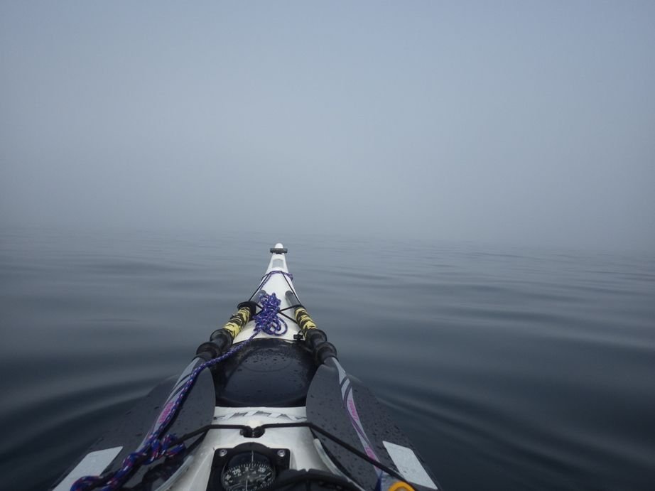
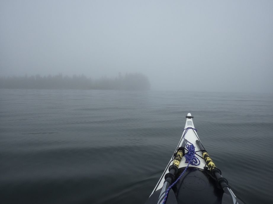
You do not see the GPS in the photo, that was sitting on top of m spray skirt, so I could look down at it and see where I am on the map. Photo below, that is exactly where I wanted to be when I got close enough to see land. I wanted to pass this island on my left.
I typed in test as a name. When I have multiple maps on my GPS SD card, the name I type is the name of the map if my memory is correct. (I have not done this for months, I might have that wrong.) I click extract. Then it sends me an e-mail telling me when my map is ready. When it is, I put the IMG file onto my GPS. I think this website is limited to half a GB per map, I might have too much area on that map in the example, if that happens, make it a bit smaller.
They have other formats, I have not played too much with various formats, I found I liked this format for biking so that is what I have used for years.
Since the GPS I use takes AA batteries and I saw some Etrex models do too, you can either buy disposable or NiMH or Li Ion rechargeable. I have not bought disposable AA or AAA for over a decade and a half. I use Ladda 2450 NiMH rechargable from Ikea or if not near an Ikea, Eneloop batteries. I mentioned in my previous post I can charge them in my GPS, but I think you can't with the Etrex.
I mentioned you can also buy AA or AAA that are Lithium Ion. I recently bought some of them too, have not tried them on a bike yet. They put out a constant 1.5v until they are empty. So, they very suddenly will be empty and you need to swap batteries. Thus, they might not be the best choice for bike touring as you may look at your GPS and suddenly realize it is off, time to pull over and swap batteries, which could be an inconvenient time. But if you want to try those, they can be charged by plugging a USB-C or Micro USB cable into the battery. You might find some of these on amazon if you are interested. I am using these at home on some electronics that work best at 1.5v, like my kitchen scale, etc.
Over the years I have bought three or four different AA/AAA chargers that run on a USB cable. The Powerchimp I used on my 2019 tour is below:
In the above example, three batteries are still charging, one is full. Same device below not plugged in. I am charging AAA in this example, can also charge AA.
Or a different AA charger. Photo below has the Eneloop chargers that can charge two AA and a camera batter charger, not sure if these Eneloop chargers are still made, photo is nine years old so the chargers are older than that. I was charging up two sets of batteries from a wall charger in Iceland.
I have a dynohub on my front wheel. I use a Cycle2Charge to convert my electric output from that to USB. I put that power into a powerbank when I am rolling with my lights off. (My taillight flasher is battery powered, not powered from dynohub.)
I suspect you can't buy Cycle2Charge chargers any more, they are made and shipped from Germany and I think nobody in Germany is shipping stuff to USA due to the tariff uncertainty. That said, I used to use a Sinewave Revolution, they are still available because that company is in USA. And there are several other options to convert dyhohub output to USB power.
I use a Voltaic powerbank, I can charge it and discharge it simultaneously. In other words, I can plug my dynohub charger in to charge it while I am using the powerbank to charge other devices like my phone.
But kayaking or canoeing or backpacking, I bring a lot of batteries, do not try to charge them during a trip. I brought a solar panel on one trip but decided that the batteries were lighter than the panel was for the amount of power that I actually got out of the panel.
On my last tour a year ago, described here, there is a section on electrics. Describes some of this in more detail.
Bike Tour near Lake Ontario and part of Erie Canal - June 2024
For other activities I usually use topo maps from this site:
https://www.gmaptool.eu/en/content/u...-topo-routable
Your last comment, your Son did not provide enough power, what did you put the power from the Son into?
I am somewhat obsessive to make sure I am not wasting power. When the visibility is good enough to have my dyno powered lights off, I am charging my powerbank (Voltaic). But, dynohub output is only giving me roughly 2 watts on average into my power bank when you factor in hills, photo stops along the way, etc. On a hilly segment, cut that in half. And my taillight flashers are powered by AAA. Thus, most of the time my hub is only used to charge batteries.
My 2019 tour, I did not even put dyno powered lights on my bike, the dynohub was only used to charge batteries. If I needed a headlamp on my bike, I had a cheap light that is powered by USB cable that I could plug into my powerbank, but I never needed that light.
Since I am setup for charging AA and AAA batteries, my headlamp (for my head) is powered by AA too.
I bought my first GPS over two decades ago for kayaking. If I was paddlng towards an island and the fog came in, I did not want to accidently paddle past the island. The GPS I bought did not have a built in map, but I could enter waypoints with Lat and Long locations, so I put all the campsites I might want to go to into the GPS. Then I felt safe paddling in fog towards a campsite. Example below, this is on Lake Superior:
You do not see the GPS in the photo, that was sitting on top of m spray skirt, so I could look down at it and see where I am on the map. Photo below, that is exactly where I wanted to be when I got close enough to see land. I wanted to pass this island on my left.
 09-14-25 | 02:27 PM
#28
Senior Member


Joined: Jul 2007
Posts: 8,603
Likes: 3,532
From: South shore, L.I., NY
Bikes: Trek Emonda SL7, Cannondale Topstone, Miyata City Liner, Specialized Chisel, Specialized Epic Evo
Biking dedicated GPS are organically designed to make it easy to create a route or multiple routes on Garmin or third party and get those routes onto the device very easily. If you need to transfer .gpx files to a hiking model, which I don't know how well that works and is a bit more work involved every day. My preference is an Edge with good battery life like a 1040. OTOH, I have followed a couple doing a cross USA as well as cross France who used a generic Android phone and Kamoots. The phone had an external battery for supplemental power. This seemed to work very well for them, so it's a good option it seems.
09-14-25 | 04:10 PM
#29
Senior Member

Joined: Aug 2010
Posts: 12,728
Likes: 2,106
From: Madison, WI
Bikes: 1961 Ideor, 1966 Perfekt 3 Speed AB Hub, 1994 Bridgestone MB-6, 2006 Airnimal Joey, 2009 Thorn Sherpa, 2013 Thorn Nomad MkII, 2015 VO Pass Hunter, 2017 Lynskey Backroad, 2017 Raleigh Gran Prix, 1980s Bianchi Mixte on a trainer. Others are now gone.
I suppose a GPS could be used to tell you how far you are from the next rapids, but in that case you could put it away in your PFD pocket before you get into the rapids.
I have a bit too much stuff on the outside of the boat to try white water.
 09-14-25 | 04:18 PM
#30
Senior Member
Joined: Jul 2007
Posts: 8,603
Likes: 3,532
From: South shore, L.I., NY
Bikes: Trek Emonda SL7, Cannondale Topstone, Miyata City Liner, Specialized Chisel, Specialized Epic Evo
Got it. I only sea kayak, not white water. And in white water, you don't really need a GPS because your only choice is to go downstream.
I suppose a GPS could be used to tell you how far you are from the next rapids, but in that case you could put it away in your PFD pocket before you get into the rapids.
I have a bit too much stuff on the outside of the boat to try white water.
I suppose a GPS could be used to tell you how far you are from the next rapids, but in that case you could put it away in your PFD pocket before you get into the rapids.
I have a bit too much stuff on the outside of the boat to try white water.
09-14-25 | 04:20 PM
#31
Senior Member
Joined: Aug 2010
Posts: 12,728
Likes: 2,106
From: Madison, WI
Bikes: 1961 Ideor, 1966 Perfekt 3 Speed AB Hub, 1994 Bridgestone MB-6, 2006 Airnimal Joey, 2009 Thorn Sherpa, 2013 Thorn Nomad MkII, 2015 VO Pass Hunter, 2017 Lynskey Backroad, 2017 Raleigh Gran Prix, 1980s Bianchi Mixte on a trainer. Others are now gone.
Not sure why you need to replace the screen. I have replaced a screen on a 64ST that I bought used on Ebay, followed instructions I saw on a couple youtube videos, the screen cost about $20 for an aftermarket one, but that was before tariffs. I could see in the photos before I bought the GPS that I would need a new screen.
I put clear packing tape on my GPS screens when new, replace the tape when it gets scrapped up enough.
Now you can buy powerbanks that hold a lot of watt hours. And a high charger USB-C charger that can charge them up pretty fast. If what you have burns through battery too fast, maybe you need a better power bank(s).
09-14-25 | 04:26 PM
#32
Senior Member
Joined: Aug 2010
Posts: 12,728
Likes: 2,106
From: Madison, WI
Bikes: 1961 Ideor, 1966 Perfekt 3 Speed AB Hub, 1994 Bridgestone MB-6, 2006 Airnimal Joey, 2009 Thorn Sherpa, 2013 Thorn Nomad MkII, 2015 VO Pass Hunter, 2017 Lynskey Backroad, 2017 Raleigh Gran Prix, 1980s Bianchi Mixte on a trainer. Others are now gone.
My Windows 10 computer became my travel computer a year and a half ago when I replaced it with the new one.
I try to put together my routes in track format, not route format. The track format puts a heavy purple line on my screen to follow. The route format also keeps beeping at me when to take turns etc., the track format does not give me any audio.
09-14-25 | 04:34 PM
#33
Senior Member
Joined: Aug 2010
Posts: 12,728
Likes: 2,106
From: Madison, WI
Bikes: 1961 Ideor, 1966 Perfekt 3 Speed AB Hub, 1994 Bridgestone MB-6, 2006 Airnimal Joey, 2009 Thorn Sherpa, 2013 Thorn Nomad MkII, 2015 VO Pass Hunter, 2017 Lynskey Backroad, 2017 Raleigh Gran Prix, 1980s Bianchi Mixte on a trainer. Others are now gone.
Biking dedicated GPS are organically designed to make it easy to create a route or multiple routes on Garmin or third party and get those routes onto the device very easily. If you need to transfer .gpx files to a hiking model, which I don't know how well that works and is a bit more work involved every day. My preference is an Edge with good battery life like a 1040. OTOH, I have followed a couple doing a cross USA as well as cross France who used a generic Android phone and Kamoots. The phone had an external battery for supplemental power. This seemed to work very well for them, so it's a good option it seems.
About 11 months ago I finally upgraded my phone to an Android 14 (now 15) phone. I was curious if I could download a GPX file off internet and put on my non-cycling GPS (mine uses a USB-Mini, not a Micro cable). It worked quite easily.
I was not able to do that with my Android 7 phone that I finally replaced last year, but now I can do that with a newer phone.
09-14-25 | 05:20 PM
#34
Senior Member
Joined: Mar 2010
Posts: 2,647
Likes: 2,217
Or he could use a truck like everyone else!
Last edited by Atlas Shrugged; 09-14-25 at 05:37 PM.
09-14-25 | 09:08 PM
#35
Broken neck Ken
Joined: Oct 2008
Posts: 5,221
Likes: 3,516
From: Portland, OR
Bikes: Trek Domane SL6 Gen 3, Soma Fog Cutter, Detroit Bikes Sparrow FG, Trek Mt Track XCNimbus MUni
I used an eTrex for randonneuring for several years, then moved on to a Garmin 1040. The eTrex never crashed, and I could power it for any ride by carrying necessary number of batteries. But the screen was hard to read in full sun, navigation capabilities limited, uploading routes is via USB cable. The 1040 runs for a legit 100 hours, upload routes via phone, bright display, fabulous navigation. Is has crashed twice, which is annoying but at least recovered with a reboot. All the training, nutrition, coaching features though, are wasted on me.
I'm hearing about Coros Dura from some randonneur as an option. 100+ hours, fewer features; just navigation and recording. Definitely requires a phone; see review on dcrainmaker.
I'm hearing about Coros Dura from some randonneur as an option. 100+ hours, fewer features; just navigation and recording. Definitely requires a phone; see review on dcrainmaker.
09-14-25 | 09:36 PM
#36

Rider. Wanderer. Creator.

Joined: May 2007
Posts: 2,941
Likes: 4,201
From: New Jersey
Bikes: Bike Friday All-Packa, Zizzo Liberte, Ozark Trail G.1 Explorer
There is a reason why there are cycling-specific GPS navigation computers, and yes, you should feel uncomfortable with your choice. It is going against what a vast majority of touring cyclists are using. Onboard cycling-specific navigation, built in worldwide maps, searchable services such as accommodation, bike shops, etc., simple wireless route transfer, popularity routing which takes other users into account, live tracking, incident monitoring, live weather radar, etc. The only people advocating for the use of Etrex are those who have never used a current, full-featured Edge device.
__________________
Rider. Wanderer. Creator.
JohnMFlores.com | YouTube: JohnMFlores
Insta: JohnMichaelFlores | Substack: https://followingwyman.substack.com/
Rider. Wanderer. Creator.
JohnMFlores.com | YouTube: JohnMFlores
Insta: JohnMichaelFlores | Substack: https://followingwyman.substack.com/
09-14-25 | 10:31 PM
#37
Senior Member
Joined: May 2021
Posts: 3,135
Likes: 2,342
From: San Francisco
Bikes: addict, aethos, creo, vanmoof, sirrus, public ...
 09-15-25 | 06:43 AM
#38
Senior Member
Joined: Jun 2007
Posts: 1,590
Likes: 100
From: Walyalup, Australia
Bikes: Surly Long Haul Trucker, Salsa Mukluk, Riese & Muller Supercharger GT Rohloff (Forthcoming)
09-15-25 | 10:34 AM
#39
Rider. Wanderer. Creator.
Joined: May 2007
Posts: 2,941
Likes: 4,201
From: New Jersey
Bikes: Bike Friday All-Packa, Zizzo Liberte, Ozark Trail G.1 Explorer
Have you by any chance tried the SuperCycle app on your phone, or do you use other apps?
__________________
Rider. Wanderer. Creator.
JohnMFlores.com | YouTube: JohnMFlores
Insta: JohnMichaelFlores | Substack: https://followingwyman.substack.com/
Rider. Wanderer. Creator.
JohnMFlores.com | YouTube: JohnMFlores
Insta: JohnMichaelFlores | Substack: https://followingwyman.substack.com/
09-18-25 | 10:23 AM
#40
Thread Starter
Junior Member
Joined: Oct 2015
Posts: 96
Likes: 18
From: France C�vennes
Bikes: Santos travelmaster2.8 ; Brompton titanium ; R&M Load speed
If the one you have works for you, I would stick with it. When you said you wanted to replace the battery, I immediately assumed you meant frequent replacement, like AA. I did not realize you mean after several years.
Not sure why you need to replace the screen. I have replaced a screen on a 64ST that I bought used on Ebay, followed instructions I saw on a couple youtube videos, the screen cost about $20 for an aftermarket one, but that was before tariffs. I could see in the photos before I bought the GPS that I would need a new screen.
I put clear packing tape on my GPS screens when new, replace the tape when it gets scrapped up enough.
Now you can buy powerbanks that hold a lot of watt hours. And a high charger USB-C charger that can charge them up pretty fast. If what you have burns through battery too fast, maybe you need a better power bank(s).
09-19-25 | 10:22 PM
#41
Senior Member
Joined: Jun 2007
Posts: 1,590
Likes: 100
From: Walyalup, Australia
Bikes: Surly Long Haul Trucker, Salsa Mukluk, Riese & Muller Supercharger GT Rohloff (Forthcoming)
Looks interesting but I haven't used it. For day rides, I'm using my Garmin watch these days because it tracks HR. It integrates with Strava, which I'm kind of vested in a this point because of all the data that I have there. On multiday trips, I'm not tracking things like HR so I'm using OsmAnd on my phone
09-20-25 | 04:20 AM
#42
Thread Starter
Junior Member
Joined: Oct 2015
Posts: 96
Likes: 18
From: France C�vennes
Bikes: Santos travelmaster2.8 ; Brompton titanium ; R&M Load speed
You wanted serviceable.
https://www.dcrainmaker.com/2025/09/...e-battery.html
https://www.dcrainmaker.com/2025/09/...e-battery.html
But I don't think Garmin is still able to repair this unit.
I thought that new is necessarily better, the average idiot customer !
09-20-25 | 04:40 AM
#43
Senior Member
Joined: Aug 2010
Posts: 12,728
Likes: 2,106
From: Madison, WI
Bikes: 1961 Ideor, 1966 Perfekt 3 Speed AB Hub, 1994 Bridgestone MB-6, 2006 Airnimal Joey, 2009 Thorn Sherpa, 2013 Thorn Nomad MkII, 2015 VO Pass Hunter, 2017 Lynskey Backroad, 2017 Raleigh Gran Prix, 1980s Bianchi Mixte on a trainer. Others are now gone.
I replaced the screen on a Garmin 64ST, but that was just a piece of clear plastic with some adhesive and some printing on it. And got some help from a couple Youtube videos showing me how to do it.
On my bike or other outdoors activities, I want real buttons instead of touch screen.
10-06-25 | 01:23 PM
#44
Rider. Wanderer. Creator.
Joined: May 2007
Posts: 2,941
Likes: 4,201
From: New Jersey
Bikes: Bike Friday All-Packa, Zizzo Liberte, Ozark Trail G.1 Explorer
Recently got the "Wet USB" alert on a motorcycle trip. I was able to charge wirelessly but iit was not ideal


Just saw the Garmin eTrex Touch, which ticks a lot of boxes but having to pay a monthly fee for advanced map features turns me off

https://bikepacking.com/news/new-garmin-etrex-touch/
Just saw the Garmin eTrex Touch, which ticks a lot of boxes but having to pay a monthly fee for advanced map features turns me off
https://bikepacking.com/news/new-garmin-etrex-touch/
__________________
Rider. Wanderer. Creator.
JohnMFlores.com | YouTube: JohnMFlores
Insta: JohnMichaelFlores | Substack: https://followingwyman.substack.com/
Rider. Wanderer. Creator.
JohnMFlores.com | YouTube: JohnMFlores
Insta: JohnMichaelFlores | Substack: https://followingwyman.substack.com/
10-07-25 | 05:39 AM
#45
Senior Member
Joined: Aug 2010
Posts: 12,728
Likes: 2,106
From: Madison, WI
Bikes: 1961 Ideor, 1966 Perfekt 3 Speed AB Hub, 1994 Bridgestone MB-6, 2006 Airnimal Joey, 2009 Thorn Sherpa, 2013 Thorn Nomad MkII, 2015 VO Pass Hunter, 2017 Lynskey Backroad, 2017 Raleigh Gran Prix, 1980s Bianchi Mixte on a trainer. Others are now gone.
Not all kayaking is down a river. I use my Edge 1040 on lakes in the Adirondacks when I need to know my position and the location of rivers or bays I want to explore. GPS tells me that. Likewise in the bays where I live, countless islands and stuff, I need to see my position to explore canals and tidal inlets.
But in the Boundary Waters Canoe Area (northern Minnesota), most people just use a map and compass. I bring the GPS because I have it, but got by with only paper maps and compass for decades of traveling up there.
I use an extra long kayak paddle with my solo canoe.

Kayak paddle drips a lot of water into the canoe, but with the rubber boots and waterproof packs, not a problem.
10-12-25 | 07:07 PM
#46
Harsh Adventurer
Joined: May 2009
Posts: 108
Likes: 23
From: Reston Virginia
Bikes: Co-Op adv1.1, Cannondale Synapse 105 Carbon
Hi there,
My latest buy was a Garmin Explore 820. Honestly I hate it : the display is really small, the accuracy really perfectible. And the unit is totally glued : it's almost impossible to replace the battery or the screen.
I'm looking for an alternative Touring self serviceable GPS : is there something available somewhere reliable enough ?
I just need a good mapping and a reliable itinerary planner, possibly with a correct battery.
I'm ageing, so do my bike : it's a Santos TravelMaster 2.8 with Magura rim brakes, a Rohloff with an outdated Gates belt drive. The wheels are a bit too thin, anyway, I'm still happy with it. Changing for something more "modern" is out of question, money wise at 65. Plus my wife would be horrified to see another new bike...
10-13-25 | 07:21 AM
#47

aka Tom Reingold

Joined: Jan 2009
Posts: 44,193
Likes: 6,428
From: New York, NY, and High Falls, NY, USA
Bikes: 1962 Rudge Sports, 1971 Raleigh Super Course, 1971 Raleigh Pro Track, 1974 Raleigh International, 1975 Viscount Fixie, 1982 McLean, 1996 Lemond (Ti), 2002 Burley Zydeco tandem
__________________
Tom Reingold, tom@noglider.com
New York City and High Falls, NY
Blogs: The Experienced Cyclist; noglider's ride blog
�When man invented the bicycle he reached the peak of his attainments.� � Elizabeth West, US author
Please email me rather than PM'ing me. Thanks.
Tom Reingold, tom@noglider.com
New York City and High Falls, NY
Blogs: The Experienced Cyclist; noglider's ride blog
�When man invented the bicycle he reached the peak of his attainments.� � Elizabeth West, US author
Please email me rather than PM'ing me. Thanks.
