


Elevation gain
 07-25-21 | 10:32 PM
#26
Senior Member


Joined: Sep 2007
Posts: 15,252
Likes: 1,759
From: Far beyond the pale horizon.
Pilots of aircraft also depend on getting the altimeter setting, which is a correction factor to allow their barometric instruments to show them an accurate altitude or clearance to tercrain. Each air traffic controller will routinely give the altimeter setting for that area so the pilots know what to set on their altimeters.
There are various methods for GPS devices with a barometric sensor use to calibrate their reading to the actual elevation, but that initially takes effort from the user and only works for predetermined locations. And the GPS device AFAIK only calibrates itself at the beginning of a ride. So normal changes in barometric pressure will produce errors in what is actually done.
Almost any ride I do, the elevation I left my house at is not the shown elevation when I return.
How different is the elevation at the start and the end?
Drift in the reading (if it's slow) probably won't change the gain by much.
Small gains over large distances likely have a higher percentage of noise.
Last edited by njkayaker; 07-25-21 at 10:47 PM.
 07-25-21 | 10:36 PM
#27

climber has-been


Joined: Dec 2004
Posts: 9,149
Likes: 6,044
From: Palo Alto, CA
Bikes: Scott Addict RC Pro & R1, Felt Z1
Having an accurate elevation is useful in one situation: when you know the elevation of the summit of your climb, and you want to know how much more climbing you have remaining.
__________________
Ride, Rest, Repeat. ROUVY: terrymorse

Ride, Rest, Repeat. ROUVY: terrymorse
07-25-21 | 10:42 PM
#28
Senior Member
Joined: Sep 2007
Posts: 15,252
Likes: 1,759
From: Far beyond the pale horizon.
You can also get that information from the relative elevation in the track file (if you are using one), which is how Garmin's "climbpro" works.
Accurate gain doesn't require accurate altitude. If the altitude is off by a constant amount over the course of a ride, the gain will still be the same.
Last edited by njkayaker; 07-25-21 at 11:18 PM.
07-25-21 | 11:04 PM
#29
Senior Member
Joined: Sep 2007
Posts: 15,252
Likes: 1,759
From: Far beyond the pale horizon.
From Sunnto
A Google search of accuracy of the two measurements give a raw error of 10m to 20 m for GPS (35 to 70 feet) while barometers are accurate to �15 meters. The error is almost the same per measurement. GPS may suffer more from a refresh rate that a barometer doesn’t experience. GPS is averaged over several seconds while barometric pressure may be closer to instantaneous as it is an on-board instrument. If you are stationary, this may no make much difference but when mobile, that averaging can lead to larger errors. Most phones have both GPS and a barometer to increase accuracy.
A Google search of accuracy of the two measurements give a raw error of 10m to 20 m for GPS (35 to 70 feet) while barometers are accurate to �15 meters. The error is almost the same per measurement. GPS may suffer more from a refresh rate that a barometer doesn’t experience. GPS is averaged over several seconds while barometric pressure may be closer to instantaneous as it is an on-board instrument. If you are stationary, this may no make much difference but when mobile, that averaging can lead to larger errors. Most phones have both GPS and a barometer to increase accuracy.
Altitude Accuracy
07-25-21 | 11:08 PM
#30
Senior Member
Joined: Sep 2007
Posts: 15,252
Likes: 1,759
From: Far beyond the pale horizon.
If you are interested in gain, the measurements "on different days" won't really matter.
07-25-21 | 11:55 PM
#31
Me duelen las nalgas

Joined: Aug 2015
Posts: 13,519
Likes: 2,832
From: Texas
Bikes: Centurion Ironman, Trek 5900, Univega Via Carisma, Globe Carmel
Strava and some other activity apps reference existing databases for elevation, based on map data and data submitted by users who post data based on their computers and phones. Presumably these are reasonably accurate. At least it offers a fairly consistent baseline.
My XOSS G+ bike computer has a barometric pressure sensor and the elevation estimates vary wildly depending on the weather. I never even look at it during rides.
And because my computer elevation data is unreliable, after syncing my ride to Strava, I then use Strava's options to correct elevation and distance. This at least makes the other data relevant in comparisons with rides on the same routes.
07-26-21 | 03:58 AM
#33
Enthusiastic Sufferer
Joined: Nov 2017
Posts: 229
Likes: 311
From: Perth, Australia
Bikes: 2015 Specialized Roubaix, 2014 Salsa Fargo, 2013 Trek Remedy, 2014 Cannondale Synapse
^^^This. I and many of my riding friends use Wahoo to record and our elevations can vary by hundreds of feet on a ride. The Strava elevation correction reduces the variance substantially. It doesn't matter to me which is correct as long as I have consistency. To further muddy the water, we use RWGPS to plan routes. We rarely end up with the predicted elevation. Sometimes more, sometimes less. I can't see how a few hundred feet would matter either way.
Those extra 700m are way harder when you don't know they're coming
07-26-21 | 04:54 AM
#34
Senior Member
Joined: May 2021
Posts: 11,620
Likes: 7,017
The correction feature is disabled by default for devices that use a barometer. It's enabled for devices that only use GPS.
Garmin rates barometric data as better than GPS for elevation.
The manual calibration is useful for determining altitude (which few cyclists care about). It should not matter for elevation gain.
Garmin rates barometric data as better than GPS for elevation.
The manual calibration is useful for determining altitude (which few cyclists care about). It should not matter for elevation gain.
07-26-21 | 05:04 AM
#35
Senior Member
Joined: May 2021
Posts: 11,620
Likes: 7,017
Sure. But that's not a common interest. (I didn't say it wasn't ever useful.) It also wouldn't let you know how much more if there were inflection points.
You can also get that information from the relative elevation in the track file (if you are using one), which is how Garmin's "climbpro" works.
Accurate gain doesn't require accurate altitude. If the altitude is off by a constant amount over the course of a ride, the gain will still be the same.
You can also get that information from the relative elevation in the track file (if you are using one), which is how Garmin's "climbpro" works.
Accurate gain doesn't require accurate altitude. If the altitude is off by a constant amount over the course of a ride, the gain will still be the same.
07-26-21 | 08:29 AM
#36
Facts just confuse people

Joined: Jul 2017
Posts: 19,317
Likes: 7,049
From: Mississippi
Bikes: Tarmac Disc Comp Di2 - 2020
The calibration is necessary for determining altitude. But cyclists don't care too often about that.
How different is the elevation at the start and the end?
Drift in the reading (if it's slow) probably won't change the gain by much.
Small gains over large distances likely have a higher percentage of noise.
How different is the elevation at the start and the end?
Drift in the reading (if it's slow) probably won't change the gain by much.
Small gains over large distances likely have a higher percentage of noise.
I agree the calibration is only needed for those that want to know their elevation. I've never understood the need to know actual elevation for cycling. My house is the normal start point for my rides so I have the driveway as a calibration waypoint. On the topo maps of my area a contour line goes right through it. But even that might be incorrect as the topo maps data set includes data from times before this house or even the subdivision was built. So who knows and why should I really care? I don't!
I'm not suggesting this is the reason for the OP. But this and other things can add up to always make the relative or actual elevation numbers be different from one ride to the next.
There is even an overpass I travel routinely and on days with the wind blowing steady from the soutwest, I'll show a higher elevation going over it than days with no wind. I wonder if that is a localized reduction in air pressure because the wind is being funneled along that area at a higher velocity than air elsewhere. So Bernoulli's Principle might be another reason for errors in elevation or gain/loss calcs. And it can occur in many places.
For me, elevation gain/loss is a lot like Calories. The actual exact number is not important. If someone wants to ride hilly terrain, then ride the routes that show the most gain loss per distance. Doesn't matter if they don't match up from day to day.
Map data isn't correct for total elevation gain, nor are our barometric sensors in our devices and certainly GPS calculate altitude is less trustworthy. So people need to learn to judge by the trends and not the actual exact number they will never have.
07-26-21 | 08:31 AM
#37
climber has-been
Joined: Dec 2004
Posts: 9,149
Likes: 6,044
From: Palo Alto, CA
Bikes: Scott Addict RC Pro & R1, Felt Z1
Like this Strava segment, based on some very noisy user-uploaded data.
The actual grade is about 7%, but Strava says it's 12.3%. Strava says the KOM rider climbed it with a VAM of 2703 meters per hour, which is ridiculous.
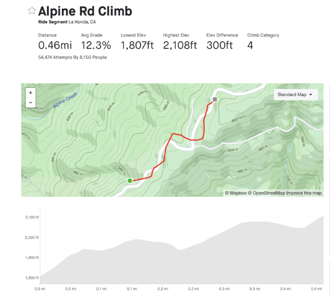
Bad Strava segment
Here's what that segment would look like with "good" GPS data:

"good" Strava segment
__________________
Ride, Rest, Repeat. ROUVY: terrymorse
Ride, Rest, Repeat. ROUVY: terrymorse
07-26-21 | 08:40 AM
#38
climber has-been
Joined: Dec 2004
Posts: 9,149
Likes: 6,044
From: Palo Alto, CA
Bikes: Scott Addict RC Pro & R1, Felt Z1
There is even an overpass I travel routinely and on days with the wind blowing steady from the soutwest, I'll show a higher elevation going over it than days with no wind. I wonder if that is a localized reduction in air pressure because the wind is being funneled along that area at a higher velocity than air elsewhere. So Bernoulli's Principle might be another reason for errors in elevation or gain/loss calcs.
I've noticed this on climbs with lots of switchbacks. When I'm climbing a portion with a tailwind, the climbing rate number is steady. But when I round a hairpin and turn into the wind, I'll briefly see a burst of increased climbing rate.
Alas, it's only a brief and false moment of glory.
__________________
Ride, Rest, Repeat. ROUVY: terrymorse
Ride, Rest, Repeat. ROUVY: terrymorse
07-26-21 | 09:04 AM
#39
Senior Member
Joined: Sep 2007
Posts: 15,252
Likes: 1,759
From: Far beyond the pale horizon.
The weather here has been pretty stable. No fronts of areas of high and low pressure moving through. Just sometimes rain and a thunderstorm that develop and dissipate in pretty much the same general area. So my last 5 rides over 2 hours had a start finish difference averaging 48 feet. The biggest 62 feet and the smallest 38 feet. Not a lot. However some where back in my history I've seen on the order of 100 feet of change or more during a ride.
There also isn't a "right" elevation gain number. It has to smooth the data (otherwise, it would count every little jiggle).
Since elevation gain is not considering grade at all, it's a weak indicator of effort anyway.
For me, elevation gain/loss is a lot like Calories. The actual exact number is not important. If someone wants to ride hilly terrain, then ride the routes that show the most gain loss per distance. Doesn't matter if they don't match up from day to day.
Map data isn't correct for total elevation gain, nor are our barometric sensors in our devices and certainly GPS calculate altitude is less trustworthy. So people need to learn to judge by the trends and not the actual exact number they will never have.
Map data isn't correct for total elevation gain, nor are our barometric sensors in our devices and certainly GPS calculate altitude is less trustworthy. So people need to learn to judge by the trends and not the actual exact number they will never have.
Last edited by njkayaker; 07-26-21 at 09:12 AM.
07-26-21 | 10:43 AM
#40
Perceptual Dullard
Joined: Sep 2009
Posts: 2,916
Likes: 1,754
07-26-21 | 10:52 AM
#41
Senior Member
Joined: Sep 2007
Posts: 15,252
Likes: 1,759
From: Far beyond the pale horizon.
How long is a coastline?
There isn't one standard for smoothing the data and what changes to include or drop.
I had a Bontrager computer that was kinda close to my Edge 800.
Which ones and how? Is it any of the common ones?
One might be able to take the gain and divide it by distance. But that wouldn't be gain (it would be a gain rate or ratio). Or, I suppose, one could ignore gain below some sort of grade threshold.
Last edited by njkayaker; 07-26-21 at 11:08 AM.
07-26-21 | 11:10 AM
#42
Klaatu..Verata..Necktie?
Joined: May 2007
Posts: 23,613
Likes: 17,075
From: SF Bay Area
Bikes: Litespeed Ultimate, Ultegra; Canyon Endurace, 105; Battaglin MAX, Chorus; Bianchi 928 Veloce; Ritchey Road Logic, Dura Ace; Cannondale R500 RX100; Schwinn Circuit, Sante; Lotus Supreme, Dura Ace
This is my observation when using Garmin's elevation correction for mountainous switchback rides. On each turn the GPS drops me off the cliff and then climbs me back up adding 1000s of feet to the ride. It makes me look good but i switch this feature off. Regrettably it seems permanently activated when using the Connect route planning function, so I defer to RWGPS when planning a ride.
Luckily, the fall didn't kill me.
__________________
"Don't take life so serious-it ain't nohow permanent."
"Everybody's gotta be somewhere." - Eccles
"Don't take life so serious-it ain't nohow permanent."
"Everybody's gotta be somewhere." - Eccles
07-26-21 | 11:16 AM
#43
Klaatu..Verata..Necktie?
Joined: May 2007
Posts: 23,613
Likes: 17,075
From: SF Bay Area
Bikes: Litespeed Ultimate, Ultegra; Canyon Endurace, 105; Battaglin MAX, Chorus; Bianchi 928 Veloce; Ritchey Road Logic, Dura Ace; Cannondale R500 RX100; Schwinn Circuit, Sante; Lotus Supreme, Dura Ace
I tried "starring" OLH so that I could track my progress relative to my previous best time. TWICE I started up the climb and less than half a mile into it my Garmin said I was "off segment" and stopped giving me those data. Similarly, one time when I rode up Kings Mountain,. between Garmin and Strava, I was off the road most of the time, so it didn't find segments for half the climb - so, also not for the whole climb.
__________________
"Don't take life so serious-it ain't nohow permanent."
"Everybody's gotta be somewhere." - Eccles
"Don't take life so serious-it ain't nohow permanent."
"Everybody's gotta be somewhere." - Eccles
07-26-21 | 11:18 AM
#44
Senior Member
Joined: Jul 2009
Posts: 8,145
Likes: 11,080
Bikes: Colnago, Van Dessel, Factor, Cervelo, Ritchey
Sounds like a good place for an "Everesting" record attempt.
07-26-21 | 01:17 PM
#45
Senior Member
Joined: Jul 2015
Posts: 2,672
Likes: 1,387
From: reno, nv
Bikes: yes, i have one
i'll bet the power pod could accurately measure elevation if it only knew what your elevation was when you started.
my understanding is that it uses both grade and speed to help compute power. speed and grade are all that are needed to calculate elevation gain.
https://velocomp.com/powerpod-lite/
my understanding is that it uses both grade and speed to help compute power. speed and grade are all that are needed to calculate elevation gain.
https://velocomp.com/powerpod-lite/
07-26-21 | 01:32 PM
#46
climber has-been
Joined: Dec 2004
Posts: 9,149
Likes: 6,044
From: Palo Alto, CA
Bikes: Scott Addict RC Pro & R1, Felt Z1
07-26-21 | 01:56 PM
#47
Perceptual Dullard
Joined: Sep 2009
Posts: 2,916
Likes: 1,754
You're mixing up a distance with the measurement of that distance (or, in this case, a height with the measurement of that height). This isn't a fractal problem. Distances and heights are actual things, so there is a "right" height. The measurement of that height can and does have an error, but your claim was "There also isn't a 'right' elevation gain number." There is a right elevation gain number.
Some estimates of elevation gain take grade into account.
Which ones and how? Is it any of the common ones?
Not one of the common ones, but it's one that is built on the effort it takes to climb a hill. It uses power and speed data (among other things) to build up road gradient and then integrates gradient to get elevation gain. It can reliably and repeatably reproduce small changes in road grade. Better still, we can use the Central Limit Theorem to reduce error in the elevation gained when integrating the gradient.
Originally Posted by njkayaker
Originally Posted by RChung
Originally Posted by njkayaker
Since elevation gain is not considering grade at all, it's a weak indicator of effort anyway.
07-26-21 | 01:58 PM
#48
Perceptual Dullard
Joined: Sep 2009
Posts: 2,916
Likes: 1,754
07-26-21 | 03:57 PM
#49
Senior Member
Joined: Dec 2010
Posts: 9,685
Likes: 2,603
From: northern Deep South
Bikes: Fuji Touring, Novara Randonee
 07-26-21 | 04:16 PM
#50
climber has-been
Joined: Dec 2004
Posts: 9,149
Likes: 6,044
From: Palo Alto, CA
Bikes: Scott Addict RC Pro & R1, Felt Z1
You're mixing up a distance with the measurement of that distance (or, in this case, a height with the measurement of that height). This isn't a fractal problem. Distances and heights are actual things, so there is a "right" height. The measurement of that height can and does have an error, but your claim was "There also isn't a 'right' elevation gain number." There is a right elevation gain number.
How do you define the "right" length of a coastline?
__________________
Ride, Rest, Repeat. ROUVY: terrymorse
Ride, Rest, Repeat. ROUVY: terrymorse