


Help understanding elevation gain
 03-31-12 | 06:41 PM
#1
Thread Starter
Senior Member
Joined: Jan 2012
Posts: 593
Likes: 1
From: Denver, CO
Bikes: 2012 Specialized Crux, Schwinn Mesa
Help understanding elevation gain
So I have been riding for bout 3 years consistantly and thought I might try riding an event. I have been reading about different events and noticed that they always have something saying elevation gain. I am aware that this is used as an indicator of how much climbing is involved but lack the understanding of the specifics of what elevation gain is. Any and all info pertaining to elevation gain is appreciated; please help demistify this subject for me.
 03-31-12 | 06:55 PM
#2

Senior Member


Joined: Feb 2004
Posts: 30,225
Likes: 649
From: St Peters, Missouri
Bikes: Catrike 559 I own some others but they don't get ridden very much.
If you start and end your ride in the same place for every climb there has to be a corresponding coast. Nobody talks about that.
03-31-12 | 07:10 PM
#3
Ninny
Joined: Jan 2010
Posts: 5,295
Likes: 1
From: The Gunks
If you climb a 100 foot hill, turn around and ride back down to where you started, your ride has 100 feet of climbing, even though you are starting and ending in the same place.
A 50 mile ride in a flat area might have only a few hundred feet of climbing. 50 miles in a hilly area might have 2000 feet of climbing. 50 miles in the mountains might have 5000 feet or more of climbing.
A 50 mile ride in a flat area might have only a few hundred feet of climbing. 50 miles in a hilly area might have 2000 feet of climbing. 50 miles in the mountains might have 5000 feet or more of climbing.
03-31-12 | 07:16 PM
#4


If there are three 100 foot hills on the ride, that's 300 feet of elevation gain. You don't subtract the downhill parts.
On a reasonably long ride, 100 feet per mile is considered very hilly. That's a 30 mile ride with 3000 feet of climbing, for instance. But like Retro Grouch says, that doesn't include the downhills, so if the ride returns to the starting point, the climb portions are probably at least 200 feet per mile, assuming it's mostly all hills.
Elevation gains are often reported by GPS devices, such as a Garmin. Or web sites, like ridewithgps.com, will add up the elevation changes using mapping data. Both of these count up every small change in elevation, even a few feet at a time. So the elevation numbers on an easy ride can look pretty impressive. Mapmyride.com has tried to fix this by only counting 10 meter changes in elevation, that's 33 feet. But that tends to under-report a ride with many smaller hills. So there's no perfect solution.
~~~~~~~~~~~~~~
Checking out a possible route in advance can be useful. Many organized rides have had someone post their ride to ridewithgps.com. The biggest difficulties can be long, steep climbs. Long shallow climbs are pretty easy, and small "roller" hills are easy, too.
See these three rides. Click the Terrain checkbox on the Map pulldown at the top right corner. And hover your cursor over the red elevation graph to see the grades at different points in the ride, or drag to select just a section of the ride and get it's distance and elevation reported on the right side Metrics tab
Here's a ride I consider very flat. See the ridewithgps recorded route. The middle of this 40 mile ride is at 950 feet above sea level, and the lowest is just at 687 feet. There's only a couple of hills that are even 100 feet high. Yet, the small rollers, probably only 2-4% grade and 40-70 feet high at the most, add up to 1600 feet in elevation gain over the 40 miles.
This Blue Ridge Parkway ride is hilly: 3700 feet in 49 miles. Some of the 300-400 foot climbs are over 6% grade. But at least there's some downhills mixed into the big climb from mile 12 to mile 21. And the return trip is more downhill than uphill, that helps a lot.
Here's a local ride for April Fools Day. It's 2800 feet in 43 miles, but it's very difficult. The main problem is the steep climbs, many over 8-10%, and a couple over 18%.
~~~~~~~~~~~~~~~~~~~~
The other quoted number is grade percentage. A mile long hill that is 264 feet high is exactly a 5% grade. That's 264 / (1 mile x 5280 feet) = .05
(On a hill, the grade is actually the vertical distance divided by the horizontal distance. But bikes measure the sloped distance up the hill, which is a little longer than the horizontal distance. For any reasonable grade, the two are so close together that they don't really change the calculation. So we just measure the road distance and the elevation changes)
Last edited by rm -rf; 03-31-12 at 08:01 PM.
03-31-12 | 07:45 PM
#5
Thread Starter
Senior Member
Joined: Jan 2012
Posts: 593
Likes: 1
From: Denver, CO
Bikes: 2012 Specialized Crux, Schwinn Mesa
Thanks for the explainations. I think I got a good grasp of how that works now. I didn't realize that it only counts the uphill and not the downhill. That makes a 3500 ft gain over 50 miles not seem so bad knowing that.
Here are a few more questions related to this topic:
1. What grade is considered steep
2. Are there any programs or apps that can give me the elevation gain of a particular route without having a cyclocomputer that either has an altimeter or gps function?
Here are a few more questions related to this topic:
1. What grade is considered steep
2. Are there any programs or apps that can give me the elevation gain of a particular route without having a cyclocomputer that either has an altimeter or gps function?
03-31-12 | 08:06 PM
#6
[IMG]https://i4.photobucke
Joined: Apr 2011
Posts: 754
Likes: 0
From: Inland Empire, CA
Mapmyride.com will do that, you can map out your ride and it will show a graph on bottom of the hills and total gain. I find anything over 8 percent steep for me, especially if it is a long climb.
03-31-12 | 08:33 PM
#8
Ninny
Joined: Jan 2010
Posts: 5,295
Likes: 1
From: The Gunks
50 miles / 3500 feet is a decently hilly ride. It's all relative to what you are used to of course.
2-3% is enough of a hill to feel like a climb, 5% is a real hill, 7-10% is getting steep, and over 10% is definitely steep. Very few paved roads will get over about 15% for more than a very short stretch. But again the difficulty is all relative to what you are conditioned for. Most anybody would say that a mile at 10% is a tough hill, but a casual flatlander might not be able to get up at all, and a rider who lives in the mountains might be able to ride hard all the way up.
I find this to be the easiest ride-mapping site, it will give you elevation gain for any ride you map out: https://ridewithgps.com
03-31-12 | 09:14 PM
#9
50 miles / 3500 feet is a decently hilly ride. It's all relative to what you are used to of course.
2-3% is enough of a hill to feel like a climb, 5% is a real hill, 7-10% is getting steep, and over 10% is definitely steep. Very few paved roads will get over about 15% for more than a very short stretch. But again the difficulty is all relative to what you are conditioned for. Most anybody would say that a mile at 10% is a tough hill, but a casual flatlander might not be able to get up at all, and a rider who lives in the mountains might be able to ride hard all the way up.
I find this to be the easiest ride-mapping site, it will give you elevation gain for any ride you map out: https://ridewithgps.com
2-3% is enough of a hill to feel like a climb, 5% is a real hill, 7-10% is getting steep, and over 10% is definitely steep. Very few paved roads will get over about 15% for more than a very short stretch. But again the difficulty is all relative to what you are conditioned for. Most anybody would say that a mile at 10% is a tough hill, but a casual flatlander might not be able to get up at all, and a rider who lives in the mountains might be able to ride hard all the way up.
I find this to be the easiest ride-mapping site, it will give you elevation gain for any ride you map out: https://ridewithgps.com
Select Add Content -->Map Ride.
Enter your starting city or address or zipcode to get the map to the right place.
Click a point, then click another farther down the road. The graph and distances will change on the fly as you draw the route. It's fast and easy. Undo if you make a mistake. Save the route and give it a name at the end.
When trying out possible new routes, I use the Terrain checkbox, and zoom way in. Then the hills show 3-D shaded, and there are contour lines every 40 feet of elevation, with darker lines every 200. So I can get a quick estimate of the size of the hills.
For me:
1% a slight grade is visible.
2% still easy.
4% a real climb
6% starting to be hard work. Occasional standing to work different muscles.
8% hard work, alternating standing and sitting (I have pretty low gears. Many riders are standing full time here)
10% standing up.
15% standing, going 4 mph
20% climbing as slow as I can balance, about 3-3.5 mph
Last edited by rm -rf; 03-31-12 at 09:23 PM.
03-31-12 | 10:06 PM
#10

Banned.
Joined: Dec 2005
Posts: 19,894
Likes: 5
From: Upland Ca
Bikes: Lemond Chambery/Cannondale R-900/Trek 8000 MTB/Burley Duet tandem
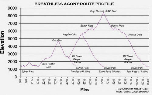
Local century (114 miles) billed as 12,000 ft gain even though the low is about 1000 and the top 8400. It's the total uphill gain.
onyxsummit by gulpxtreme, on Flickr
onyxsummit by gulpxtreme, on Flickr
03-31-12 | 11:55 PM
#11
Thread Starter
Senior Member
Joined: Jan 2012
Posts: 593
Likes: 1
From: Denver, CO
Bikes: 2012 Specialized Crux, Schwinn Mesa
After mapping one of my regular rides and reading all of your comments I feel like such a wimp. On my average ride the largest hill I deal with is sooo small. its only about eight blocks long and at its steepest part is not even 3%. 
04-01-12 | 04:36 AM
#13

In Real Life
Joined: Jan 2003
Posts: 52,159
Likes: 774
From: Down under down under
Bikes: Lots
Unless the route is Point A to Point B ... or unless there is an earthquake while you're gone and your home is thrust several metres in the air ... there is no such thing as "elevation gain". You won't have gained any elevation by the end of the ride.
__________________
Rowan
My fave photo threads on BF
Century A Month Facebook Group
Machka's Website
Photo Gallery
Rowan
My fave photo threads on BF
Century A Month Facebook Group
Machka's Website
Photo Gallery
04-01-12 | 04:39 AM
#14
In Real Life
Joined: Jan 2003
Posts: 52,159
Likes: 774
From: Down under down under
Bikes: Lots
2. You can measure the hills yourself.
__________________
Rowan
My fave photo threads on BF
Century A Month Facebook Group
Machka's Website
Photo Gallery
Rowan
My fave photo threads on BF
Century A Month Facebook Group
Machka's Website
Photo Gallery
04-01-12 | 05:35 AM
#15
Senior Member
Joined: Feb 2010
Posts: 816
Likes: 1
From: Houston TX area
Bikes: Trek 1420 triple, Mercier Corvus, Globe 1 700, Surly Disc Trucker, GT Avalanche, GT Grade, GT Helion, Mercier Corvus, Motobacane Boris X7 Fat Bikes,
Elevation gain, shown on the maps like Ride with GPS, will help determine how much time the ride will take. The more vertical elevation gain on a piont to point the longer the ride time.
If you have a steep accent and a shallow decent wind may negate the downhill section as to make it seem flat or also up hill.
For touringcycling elevation gain will help plan how far you can travel on that day and the altitude indicator may help determine your kit.
Also for training or recovery ride. If you training ride is hilly or has cat one climb your recovery ride may want to be done on a flatter route.
Where i live there are few real hills. so i compensate by using the touring bike. Me, the bike and gear run about 330 lbs. Now add a 12 tent gear.
I did 83 miles packed, with out the tent, on a flat ride yesterday. I spent last night dealing with cramps as if i had ridden several long hills. With a head wind on my return of 10 to 15 mph my average was 7.6 on the return. The wind negated any advantage of the downhill.
Elevation gain will help to determine how you will prepare you diet for and before the ride.
04-01-12 | 06:40 AM
#16

2 Fat 2 Furious
Joined: Nov 2010
Posts: 3,996
Likes: 2
From: England
Bikes: 2009 Specialized Rockhopper Comp Disc, 2009 Specialized Tricross Sport RIP
So I have been riding for bout 3 years consistantly and thought I might try riding an event. I have been reading about different events and noticed that they always have something saying elevation gain. I am aware that this is used as an indicator of how much climbing is involved but lack the understanding of the specifics of what elevation gain is. Any and all info pertaining to elevation gain is appreciated; please help demistify this subject for me.
Elevation gain can be thought of as total ascent, as opposed to total descent which might be called elevation loss. So if you start at 1000 feet, climb a steady hill to 2500 feet and then turn around and go back to the beginning your overall elevation change is nothing but your total ascent is 1500 feet, as is your total descent.
If you've got a 100 mile ride with 5000 feet of elevation gain that doesn't tell you whether you're going over gently rolling hills the entire time or have 95 miles of perfectly flat terrain followed by gaining all 5000 feet in 5 miles of truly brutal climbing that would test the Tour de France riders hard. That's where grade comes in.
As to what is "steep" and what isn't, that's something you'll find for yourself based on where you are right now and where in the ride a hill appears. A hill that's a 20% grade for a mile might be doable when you're freshly warmed up ready to go but at the end of a long ride might be more than you can cope with.
__________________
"For a list of ways technology has failed to improve quality of life, press three"
"For a list of ways technology has failed to improve quality of life, press three"
04-01-12 | 01:56 PM
#17

Mondo, something else to keep in mind is where you are. I can do rides here in the Dallas area that have 8,000' of elevation gain. Well, that turns out to be a 160 hills 50' high or something. Meanwhile, in your area, a ride with 8,000' of elevation gain is liable to go up two or three long unending grades. I think a few long grades are probably harder than a bunch of little hills, given the same total climb. Then also, if you start in Denver and climb 4,000', you're getting into a little thinner air which adds to the difficulty.
It is not uncommon to see numbers considerably different for the elevation gain of a course, so take any of those numbers with a grain of salt. Those numbers probably vary more on the bunch-of-little-hills courses.
What is "steep"? Generally, the freeway passes there around Denver don't exceed 7% grade or so. The more rural and less-well-built a road is, the steeper it is likely to be in that area. But a hill of any length that is 7% is going to slow me way down on a bike, and will get me rolling fast in a hurry on a downhill.
__________________
"be careful this rando stuff is addictive and dan's the 'pusher'."
"be careful this rando stuff is addictive and dan's the 'pusher'."
04-01-12 | 02:28 PM
#18

Senior Member

Joined: Oct 2011
Posts: 6,647
Likes: 97
From: South Hutchinson Island
Bikes: Lectric Xpedition.
Lots of words. To simplify:
0-25'/mile: board flat.
26-50 fpm: rollers a'plenty.
51-75 fpm: bring your climbing shoes.
76-100+ fpm: no doubt about it, you gonna suffa.
To me the most helpful stat is the single worst grade of a section of a climb. I can tolerate suffering, but over, say, a 15% grade, I worry about sustaining neurological impairment.
__________________
Momento mori, amor fati.
Momento mori, amor fati.
04-01-12 | 03:45 PM
#19

Senior Member
Joined: Dec 2010
Posts: 8,951
Likes: 14
I'll mention that virtually all apps use geodetic data which shows major undulations (those that cross contour lines) but not those that don't. A cyclometer that includes a baro sensor will usually show more gain than what the maps will show, sometimes quite a bit more.
04-01-12 | 03:53 PM
#20
Senior Member
Joined: Dec 2004
Posts: 12,560
Likes: 799
From: Middle of da Mitten
Bikes: Trek 7500, RANS V-Rex, Optima Baron, Velokraft NoCom, M-5 Carbon Highracer, Bacchetta Quattro, Catrike Speed
The other thing about climbing is, anybody who does less climbing than you is doing a flat ride.  It's like fishing, where the whopper gets bigger with every telling of the story. If you want to get into a climbing war, it's for sure that somebody will claim a win by having climbed to the moon and back.
It's like fishing, where the whopper gets bigger with every telling of the story. If you want to get into a climbing war, it's for sure that somebody will claim a win by having climbed to the moon and back.
04-01-12 | 04:25 PM
#21
Banned.
Joined: Dec 2005
Posts: 19,894
Likes: 5
From: Upland Ca
Bikes: Lemond Chambery/Cannondale R-900/Trek 8000 MTB/Burley Duet tandem

or doing organized rides that provide the ele-graphs.

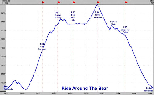
Bear by gulpxtreme, on Flickr
04-01-12 | 11:21 PM
#22
Thread Starter
Senior Member
Joined: Jan 2012
Posts: 593
Likes: 1
From: Denver, CO
Bikes: 2012 Specialized Crux, Schwinn Mesa
The ride I frequently do with the largest climb in 42 miles long and has 686ft of elevation gain. with nearly all of it comming in the last 20 miles. The largest hill doesnt even register as a cat5 hill. I am under the assumption thats the lowest rating and they go up to cat1; please tell me if I am wrong.
04-01-12 | 11:26 PM
#23
Banned.
Joined: Dec 2005
Posts: 19,894
Likes: 5
From: Upland Ca
Bikes: Lemond Chambery/Cannondale R-900/Trek 8000 MTB/Burley Duet tandem
The ride I frequently do with the largest climb in 42 miles long and has 686ft of elevation gain. with nearly all of it comming in the last 20 miles. The largest hill doesnt even register as a cat5 hill. I am under the assumption thats the lowest rating and they go up to cat1; please tell me if I am wrong.
You are wrong.
Also the Hors categorie...tougher than cat 1Hors cat�gorie is a French term used in cycle races (most notably, the Tour de France) to designate a climb that is "beyond categorization", an incredibly tough climb. Most climbs in cycling are designated from Category 1 (hardest) to Category 4 (easiest), based on both steepness and length. A climb that is harder than Category 1 is designated as hors cat�gorie. The term was originally used for those mountain roads where cars were not expected to be able to pass.
 04-02-12 | 12:12 AM
#25
Banned.
Joined: Dec 2005
Posts: 19,894
Likes: 5
From: Upland Ca
Bikes: Lemond Chambery/Cannondale R-900/Trek 8000 MTB/Burley Duet tandem
 ....it's not all that bad. Just start climbing every hill in sight. After a while, they are nearly all the same. I could be on a cat 2 or hors cat and probably not even notice the difference.