


GPS for cycling queries
 08-19-13 | 09:39 AM
#26

Senior Member
Joined: Jul 2013
Posts: 522
Likes: 0
From: Annandale, VA
Bikes: Fuji Rubaix 1.0
Not at all. I find My Tracks is useful to record my cycling as well. I also have CoPilot Live which downloads maps onto my Galaxy S3. Unfortunately it doesn't have trails in the system. Google Maps is useful for planning routes.
 08-19-13 | 10:06 AM
#27

Senior Member
Joined: Aug 2013
Posts: 1,649
Likes: 29
From: Western PA
Bikes: 2014 Giant Escape 1
Well then, I actually now use Runtastic: Road Bike app for recording my ride, though the GPS doesn't seem as accurate as my cheap $20 cycle computer. Googlemaps gives me exactly 6 miles to the other side of the tunnel on the rails to trails I ride which matches the bike computer and Runtastic gives me only 5.5 miles. Then again, I guess the GPS doesn't work real well in the tunnel. Also the bike computer calculates time and average speed riding where Runtastic calculates any stopped time as well so the elapsed time and average speed is wrong from actual riding. I think My Tracks will actually give you moving time/average and overall time/average.
08-20-13 | 03:36 AM
#28
Senior Member
Joined: Apr 2011
Posts: 193
Likes: 0
From: central florida
Son of a gun...these guys are right. Took my unactivated [only activate it when I go to events] android phone on ride this morn, and sure 'nuf, the maps gps worked fine. Thanks guys; didn't know that. Still might activate it for events though for phone service just in case I need a SAG or something. Wow...I wonder how cave men got around on their bikes? Think we are getting spoiled or something? Has anyone come up with how to hook up TV to a bike bar yet? Could watch my favorite soaps during those long flats that have no end, ha.
08-20-13 | 03:46 AM
#29
Senior Member
Joined: Aug 2013
Posts: 1,649
Likes: 29
From: Western PA
Bikes: 2014 Giant Escape 1
 08-20-13 | 11:22 AM
#30
Senior Member
Joined: Jun 2013
Posts: 70
Likes: 0
From: Pensacola, FL
Bikes: Cannondale Synapse 7 Sora
Most modern smart phones do not download maps as they go...the information is stored on the device. The phone itself gets GPS location through triangulating through multiple terrestrial towers...it's not using data. You have to keep in mind that a lot of today's phones have huge amounts of storage. I have road maps for the entire US, Canada, Central/South America, Europe, Scandinavia, Australia, and most of Asia. Whole thing only uses a couple of Gigabytes of storage...on a phone that totals over 50 GB with internal drive and removable SD card.
08-20-13 | 06:43 PM
#31

Walmart bike rider

Joined: Aug 2004
Posts: 2,131
Likes: 34
From: South Carolina
What I do with my Garmin GPS units is download each bike ride, save as gpx file. Then merge the file with all my other rides of the year, which makes one neat spider graph of every road I've ridden for the year.

That's using Delorme Topo software. I would love to find an online site that would do this.
That's using Delorme Topo software. I would love to find an online site that would do this.
 08-21-13 | 09:42 AM
#33

The Recumbent Quant

Joined: Jan 2012
Posts: 3,094
Likes: 8
From: Fairfield, CT
Bikes: 2012 Cruzbike Sofrider, 2013 Cruzigami Mantis, 2016 Folding CruziTandem
Most modern smart phones do not download maps as they go...the information is stored on the device. The phone itself gets GPS location through triangulating through multiple terrestrial towers...it's not using data. You have to keep in mind that a lot of today's phones have huge amounts of storage. I have road maps for the entire US, Canada, Central/South America, Europe, Scandinavia, Australia, and most of Asia. Whole thing only uses a couple of Gigabytes of storage...on a phone that totals over 50 GB with internal drive and removable SD card.
Most modern smart phones can store maps on the phone, but this is not the default behavior for Google maps (or Apple Maps) as far as I know.
GPS is not from terrestrial towers, but satellites. But you are correct that it doesn't use cell data. And no smart phones have "internal drives", but do have flash memory and some have removable SD cards.
08-21-13 | 09:43 AM
#34
The Recumbent Quant
Joined: Jan 2012
Posts: 3,094
Likes: 8
From: Fairfield, CT
Bikes: 2012 Cruzbike Sofrider, 2013 Cruzigami Mantis, 2016 Folding CruziTandem
That's pretty cool. Do you just merge the files by hand or do you use software to do it?
08-21-13 | 10:26 AM
#35
Senior Member
Joined: Aug 2013
Posts: 1,649
Likes: 29
From: Western PA
Bikes: 2014 Giant Escape 1
What I do with my Garmin GPS units is download each bike ride, save as gpx file. Then merge the file with all my other rides of the year, which makes one neat spider graph of every road I've ridden for the year.
That's using Delorme Topo software. I would love to find an online site that would do this.
That's using Delorme Topo software. I would love to find an online site that would do this.
08-26-13 | 12:45 PM
#36
Thread Starter
Junior Member
Joined: Apr 2013
Posts: 12
Likes: 0
Yeah, that's my understanding as well. Signals from cell towers are not how position is determined by the GPS-capable cell phones, but rather the phone calculates position based on signals received directly from GPS satellites.
08-27-13 | 07:34 PM
#37
Senior Member
Joined: Dec 2001
Posts: 7,141
Likes: 12
From: New Jersey
What I do with my Garmin GPS units is download each bike ride, save as gpx file. Then merge the file with all my other rides of the year, which makes one neat spider graph of every road I've ridden for the year.
That's using Delorme Topo software. I would love to find an online site that would do this.
That's using Delorme Topo software. I would love to find an online site that would do this.
08-27-13 | 08:16 PM
#38


The open source, free My Tourbook can do this by selecting a range of rides from it's history list. It draws all of them on a zoomable map. They can be color coded, in this case by speed--see the legend at the left side.
I uploaded my Garmin Edge .tcx files to it.
This is a zoom in showing two years of rides. The hills are either 35+ mph (red) or 5 mph (blue) depending on which direction was most recent.

I uploaded my Garmin Edge .tcx files to it.
This is a zoom in showing two years of rides. The hills are either 35+ mph (red) or 5 mph (blue) depending on which direction was most recent.
Last edited by rm -rf; 08-27-13 at 08:21 PM.
08-27-13 | 11:33 PM
#39
Walmart bike rider
Joined: Aug 2004
Posts: 2,131
Likes: 34
From: South Carolina
And thanks to rm -rf, I am going to look into that software also.
08-28-13 | 05:49 AM
#40
The Recumbent Quant
Joined: Jan 2012
Posts: 3,094
Likes: 8
From: Fairfield, CT
Bikes: 2012 Cruzbike Sofrider, 2013 Cruzigami Mantis, 2016 Folding CruziTandem
I first read that as: 'Since I used delete everything without asking, I need new software.' 
It took me a while to read it as 'Since fellow forum member 'rm -rf' suggested that software, I'm going to look into it.' as you probably intended.
It took me a while to read it as 'Since fellow forum member 'rm -rf' suggested that software, I'm going to look into it.' as you probably intended.
08-28-13 | 06:11 AM
#41
I just use software to keep adding gpx files of my rides as I save them daily. Garmin's free BaseCamp software will do that also and you can use free maps from OpenStreetMap. I use Topo 6.0, which is quite dated but around here they simply don't build any new roads but with new Delorme Topo costing $100, that's too much money for me.
And thanks to rm -rf, I am going to look into that software also.
And thanks to rm -rf, I am going to look into that software also.
~~~~~~~~~~~~~~~~~~~~~~~
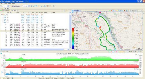
My Tourbook takes a little work to configure, since it has so many options. It runs on my local PC, no internet needed. I have it saving map tiles, so it only needs to download sections of the map one time. I overlaid the map with a 3-D shading.
Here's my normal display.
The top left is rides subtotaled by month and year. Each ride include distance, riding time and stopped time, average and max for speed, heartrate, etc, and a short description of the ride.
The top right is the zoomable map. I can make it full screen, too.
The bottom is selected graphs of the current ride. Green is elevation, Red is heartrate, Blue is speed.
If I zoom in far enough, I see each 1-second position dot from the .tcx data. Red is fastest, so the dots are farther apart.

Last edited by rm -rf; 08-28-13 at 06:14 AM.
08-28-13 | 06:31 AM
#42
Senior Member


Joined: Sep 2007
Posts: 15,308
Likes: 1,779
From: Far beyond the pale horizon.
Cell phones can also get positioning data from cell towers and wifi hot spots to "assist" the GPS positioning signal. GPS is more accurate but it can take a while to get the position at first (after being turned-on). The phones can also use this other positioning data when GPS is unavailable (like indoors). You'll see this technique listed as "assisted GPS" or "aGPS".
It's not the default behavior for most apps (including the "standard" mapping programs). It appears that most of the apps require you to explicitly download the maps.
The apps provided by Garmin/TomTom/Sklobber/others might load the maps as part of their installation process. But don't assume all or most of them do!
If you are getting maps by "magic", it's probably downloading them as needed (you can test it by turning off cell/wifi access). It's not really possible to know how every app works but, if loaded maps are a feature that is important to you, you want to do some investigating to be sure how it works.
Last edited by njkayaker; 08-28-13 at 06:45 AM.
08-28-13 | 06:59 AM
#43
Senior Member
Joined: Sep 2007
Posts: 15,308
Likes: 1,779
From: Far beyond the pale horizon.
Well then, I actually now use Runtastic: Road Bike app for recording my ride, though the GPS doesn't seem as accurate as my cheap $20 cycle computer. Googlemaps gives me exactly 6 miles to the other side of the tunnel on the rails to trails I ride which matches the bike computer and Runtastic gives me only 5.5 miles. Then again, I guess the GPS doesn't work real well in the tunnel. Also the bike computer calculates time and average speed riding where Runtastic calculates any stopped time as well so the elapsed time and average speed is wrong from actual riding. I think My Tracks will actually give you moving time/average and overall time/average.
If you are using the correct/actual wheel measurement, the cycling computer (regardless of cost) will generally be more accurate than GPS.
The GPS isn't precise enough to measure all the "weaving" that you do. And it only works when it can get a signal. If you are moving in a straight line, signal loss won't matter but, if you are on a curve, the GPS will "cut the corner" and show a shorter distance than actual.
08-28-13 | 07:09 AM
#44
Senior Member
Joined: Sep 2007
Posts: 15,308
Likes: 1,779
From: Far beyond the pale horizon.
That's pretty slick. It's usable without any configuration.
Last edited by njkayaker; 08-28-13 at 07:15 AM.

Thread
Thread Starter
Forum
Replies
Last Post
Lively or Not
Electronics, Lighting, & Gadgets
4
02-09-19 02:18 PM
