


WB&A Trail Pax River Bridge Crossing to Join PG & AA Co Trail Sections
 07-08-23, 09:05 PM
#1
Newbie
Thread Starter
WB&A Trail Pax River Bridge Crossing to Join PG & AA Co Trail Sections
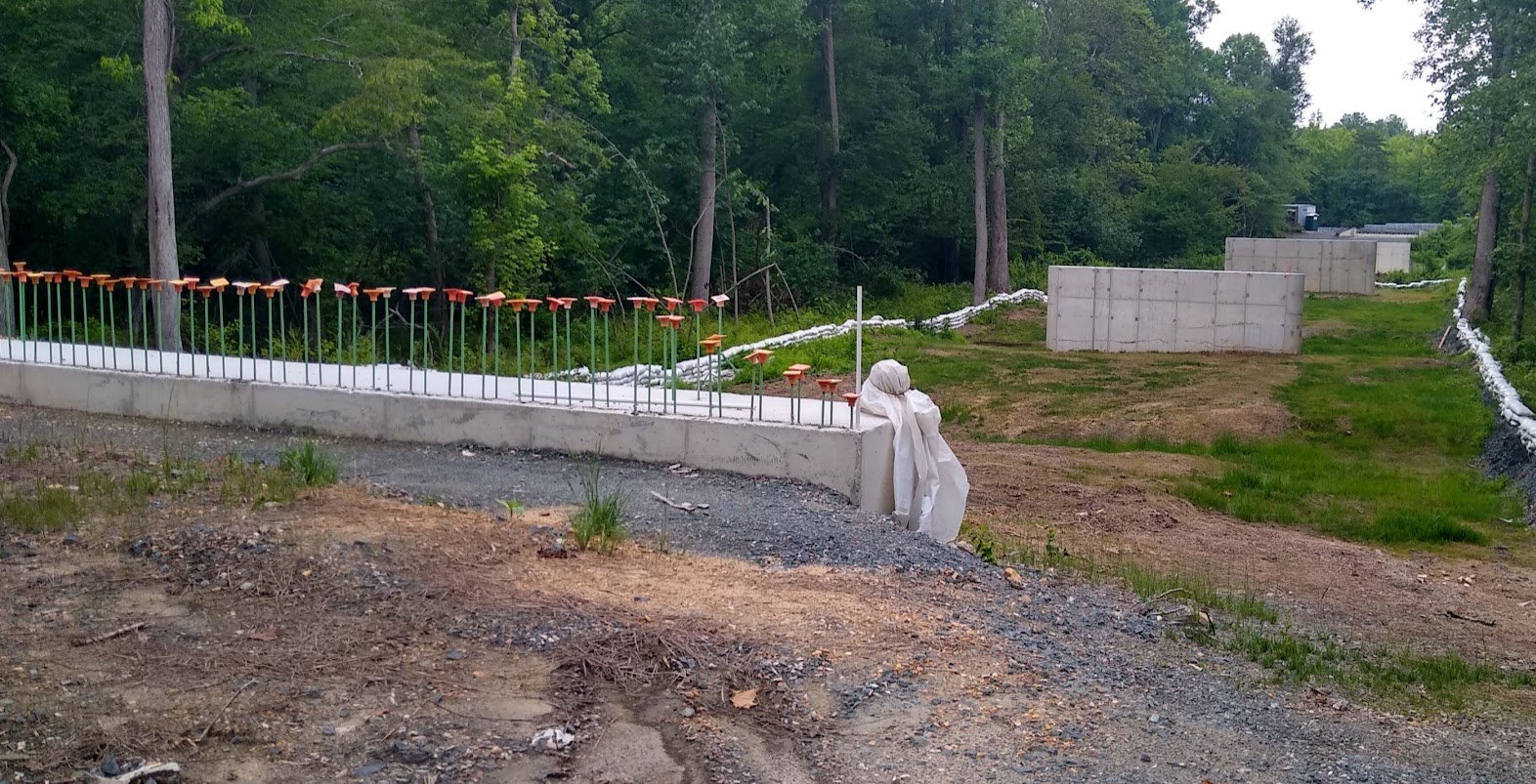
The bridge to join the PG & AA county individual sections of the WB&A trail into one continuous trail is scheduled to be completed this summer (summer 2023). I took a look at the bridge the other day. See photo from 7/5/2023 below. Photo taken from PG Co side looking across Patuxent River over onto Anne Arundel Co side. If they are going to finish it on schedule looks like they need to speed it up. Seems the concrete bridge pillars/supports have been poured. But none of the horizontal decking is in place.
Anyone aware of the actual "current" schedule to open up the bridge to join the two trail segments?
Anyone aware of the actual "current" schedule to open up the bridge to join the two trail segments?

Likes For morsetaper2:
07-09-23, 09:15 AM
#2
Newbie
Join Date: Jul 2023
Location: Maryland , USA
Posts: 2
Bikes: 09 Fuji Robiax, 14 Fuji Sunrise -Hybrid
Mentioned: 0 Post(s)
Tagged: 0 Thread(s)
Quoted: 0 Post(s)
Likes: 0
Liked 1 Time
in
1 Post
I read the sign on the Anne Arundel sign some weeks ago and it said the opening would be in September. I�m sure we riders will know when it will be as the counties will be sure to make it the big deal that it is.
Likes For Marktheroad:
07-09-23, 12:50 PM
#3
Newbie
Thread Starter
Thanks! No signage that I saw on PG Co side. But, yes, it has been a long time in the works. So they will make a big deal once it's open.
07-10-23, 01:23 PM
#5

Senior Member
Join Date: Apr 2011
Location: Maryland, USA
Posts: 2,442
Bikes: Drysdale/Gitane/Zeus/Masi/Falcon/Palo Alto/Raleigh/Legnano
Mentioned: 34 Post(s)
Tagged: 0 Thread(s)
Quoted: 987 Post(s)
Liked 641 Times
in
407 Posts
Wow, how did you get back there? Big gates and "No Trespassing" signs. Regardless, thanks for posting the photo.
PG-side WB&A is my go-to ride, I live 1.5 miles from the other end. I've been trying to dialogue with both PG and AA counties on this, the former does not respond, the latter polite but "check our Facebook page for updates". Ugh, I missed the groundbreaking and will probably miss the grand opening.
PG-side WB&A is my go-to ride, I live 1.5 miles from the other end. I've been trying to dialogue with both PG and AA counties on this, the former does not respond, the latter polite but "check our Facebook page for updates". Ugh, I missed the groundbreaking and will probably miss the grand opening.
__________________
Larry:1958 Drysdale, 1961 Gitane Gran Sport, 1974 Zeus track, 1988 Masi Gran Corsa, 1974 Falcon, 1980 Palo Alto, 1973 Raleigh Gran Sport, 1974 Legnano. Susan: 1976 Windsor Profesional.
Larry:1958 Drysdale, 1961 Gitane Gran Sport, 1974 Zeus track, 1988 Masi Gran Corsa, 1974 Falcon, 1980 Palo Alto, 1973 Raleigh Gran Sport, 1974 Legnano. Susan: 1976 Windsor Profesional.
07-10-23, 02:28 PM
#6
Newbie
Thread Starter
We actually parked at the Amtrak parking lot right near Bowie St Univ and walked down Lemons Bridge Rd, crossed under the RR tracks and came in through the woods. IOW, we came in not by way of the bike trail. I wanted to get the dog out for a long walk. We walked to the first bridge headed toward the WSSC pumping station and then we turned back at that point for the car.
07-11-23, 05:23 AM
#7
Senior Member
That will make for a nice 30 mile out and back from the north end - great to finally see!
I guess the counties are still in the exploration phase of replacing the Governor's Bridge Road Bridge that has been closed since 2015? That used to allow me to avoid the Rt. 214 bridge on some loops I do.
I guess the counties are still in the exploration phase of replacing the Governor's Bridge Road Bridge that has been closed since 2015? That used to allow me to avoid the Rt. 214 bridge on some loops I do.
07-11-23, 06:18 AM
#8
Senior Member
Join Date: Apr 2011
Location: Maryland, USA
Posts: 2,442
Bikes: Drysdale/Gitane/Zeus/Masi/Falcon/Palo Alto/Raleigh/Legnano
Mentioned: 34 Post(s)
Tagged: 0 Thread(s)
Quoted: 987 Post(s)
Liked 641 Times
in
407 Posts
My understanding is that the actual decking, the bridge sections, are to be pre-fab so completing the bridge could be very fast.
OK, I checked it out on Google Maps; in 67 years here I've never to to/near what was once Bowie State Teachers' College. No idea what's back there.
I'll be going the other way -- I'll try to remember to wave or at least nod. At least the north end has a couple of dining choices. I cannot recommend anything at the south end (OK, there's a new WaWa).
It amazes me still how few places there are to cross the Patuxent River. I have a long-time cycling friend who lives near the AA County end of that bridge, visiting for rides would be easier if they reopened it. I crossed it once, walking the bike, after the closure. I do NOT recommend that.
Well, gotta go, getting ready for a morning ride -- on the WB&A.
We actually parked at the Amtrak parking lot right near Bowie St Univ and walked down Lemons Bridge Rd, crossed under the RR tracks and came in through the woods. IOW, we came in not by way of the bike trail. I wanted to get the dog out for a long walk. We walked to the first bridge headed toward the WSSC pumping station and then we turned back at that point for the car.
Well, gotta go, getting ready for a morning ride -- on the WB&A.
__________________
Larry:1958 Drysdale, 1961 Gitane Gran Sport, 1974 Zeus track, 1988 Masi Gran Corsa, 1974 Falcon, 1980 Palo Alto, 1973 Raleigh Gran Sport, 1974 Legnano. Susan: 1976 Windsor Profesional.
Larry:1958 Drysdale, 1961 Gitane Gran Sport, 1974 Zeus track, 1988 Masi Gran Corsa, 1974 Falcon, 1980 Palo Alto, 1973 Raleigh Gran Sport, 1974 Legnano. Susan: 1976 Windsor Profesional.
07-17-23, 05:12 PM
#10
Newbie
Thread Starter
Last edited by morsetaper2; 07-17-23 at 06:10 PM.
07-20-23, 05:59 AM
#11
Newbie
Thread Starter
On youtube their are several 3-4 min videos of drone footage over the the bridge construction site starting back in 2022. Search youtube for "WB&A Bridge" and you will find them. This one below is the most recent and is from June 2023. The state of construction in the video appears to be the same as the photo in post #1. You can see the river currently has a main channel and a second smaller channel they are running through a pipe which will likely be removed after construction completes. Looks like the pipe is there to allow people and equipment to move back and forth over the smaller channel.
The bridge is wide & long as the river floods often. I used to live in Overbrook. Which is a section of Bowie that backs up to the old racetrack property. As a kid I knew all the woods, trails, and roads back there when I was growing up riding bicycles & dirt bikes back in those woods. I remember when their used to be a one lane dirt road bridge road crossing over the river into AA county adjacent to/behind the old racetrack. Not referring to the old RR bridge behind the pumping station at the end of the "original trail". That was a RR bridge. I used to ride my bicycles & dirt bikes across the road bridge into AA county. The road bridge survived hurricane Agnes flooding, but was taken down by the state a few years later as it was old & deteriorated.
Hurricane Agnes (1972) really flooded the Patuxent River. I remember the gas stations that were at the corner of 450/301 were mostly underwater. After the water receded I remember seeing trash & debris stuck in the in the trees indicating how high the water rose. There used to be a sawmill back behind the Shell station. The sawmill was gone after the flooding.
Last edited by morsetaper2; 07-20-23 at 06:03 AM.
07-24-23, 02:33 PM
#12
Senior Member
Join Date: Jan 2010
Posts: 39,250
Mentioned: 211 Post(s)
Tagged: 1 Thread(s)
Quoted: 18423 Post(s)
Liked 15,572 Times
in
7,335 Posts
My employer donated an abandoned railroad drawbridge that was to be removed and replaced with a trail bridge. It had to be wide and strong enough to accommodate emergency vehicles. As long as you�re not adding things like extra supports and piers for a wider bridge, the additional cost is probably not significant in the grand scheme of things.
07-25-23, 05:28 AM
#13
Senior Member
Join Date: Apr 2011
Location: Maryland, USA
Posts: 2,442
Bikes: Drysdale/Gitane/Zeus/Masi/Falcon/Palo Alto/Raleigh/Legnano
Mentioned: 34 Post(s)
Tagged: 0 Thread(s)
Quoted: 987 Post(s)
Liked 641 Times
in
407 Posts
Makes sense, except it appears in the pictures to be wider than the trail that leads to it, at least on the PG side?
__________________
Larry:1958 Drysdale, 1961 Gitane Gran Sport, 1974 Zeus track, 1988 Masi Gran Corsa, 1974 Falcon, 1980 Palo Alto, 1973 Raleigh Gran Sport, 1974 Legnano. Susan: 1976 Windsor Profesional.
Larry:1958 Drysdale, 1961 Gitane Gran Sport, 1974 Zeus track, 1988 Masi Gran Corsa, 1974 Falcon, 1980 Palo Alto, 1973 Raleigh Gran Sport, 1974 Legnano. Susan: 1976 Windsor Profesional.
07-25-23, 05:59 AM
#14
Senior Member
Join Date: Jan 2010
Posts: 39,250
Mentioned: 211 Post(s)
Tagged: 1 Thread(s)
Quoted: 18423 Post(s)
Liked 15,572 Times
in
7,335 Posts
Which would make sense. A new bridge is going to have raised barriers/railings on the sides, making extra space for vehicles to open doors necessary. And trail users cannot simply pull off to the side of a narrower bridge to allow for the passage of vehicles. Finally, while I am not an engineer, a wider bridge possibly distributes the load of a vehicle better. I work with a lot of engineers. Functional design elements are rarely, if ever, included just for the hell of it.
07-25-23, 09:57 AM
#15
Senior Member
Join Date: Apr 2011
Location: Maryland, USA
Posts: 2,442
Bikes: Drysdale/Gitane/Zeus/Masi/Falcon/Palo Alto/Raleigh/Legnano
Mentioned: 34 Post(s)
Tagged: 0 Thread(s)
Quoted: 987 Post(s)
Liked 641 Times
in
407 Posts
Which would make sense. A new bridge is going to have raised barriers/railings on the sides, making extra space for vehicles to open doors necessary. And trail users cannot simply pull off to the side of a narrower bridge to allow for the passage of vehicles. Finally, while I am not an engineer, a wider bridge possibly distributes the load of a vehicle better. I work with a lot of engineers. Functional design elements are rarely, if ever, included just for the hell of it.
__________________
Larry:1958 Drysdale, 1961 Gitane Gran Sport, 1974 Zeus track, 1988 Masi Gran Corsa, 1974 Falcon, 1980 Palo Alto, 1973 Raleigh Gran Sport, 1974 Legnano. Susan: 1976 Windsor Profesional.
Larry:1958 Drysdale, 1961 Gitane Gran Sport, 1974 Zeus track, 1988 Masi Gran Corsa, 1974 Falcon, 1980 Palo Alto, 1973 Raleigh Gran Sport, 1974 Legnano. Susan: 1976 Windsor Profesional.
09-05-23, 09:09 AM
#16
Senior Member
Join Date: Apr 2011
Location: Maryland, USA
Posts: 2,442
Bikes: Drysdale/Gitane/Zeus/Masi/Falcon/Palo Alto/Raleigh/Legnano
Mentioned: 34 Post(s)
Tagged: 0 Thread(s)
Quoted: 987 Post(s)
Liked 641 Times
in
407 Posts
I've been trying to locate current info on Facebook, so no avail; it's now September. I'd certainly hope to find out and opening date and/or opening ceremony for the bridge.
__________________
Larry:1958 Drysdale, 1961 Gitane Gran Sport, 1974 Zeus track, 1988 Masi Gran Corsa, 1974 Falcon, 1980 Palo Alto, 1973 Raleigh Gran Sport, 1974 Legnano. Susan: 1976 Windsor Profesional.
Larry:1958 Drysdale, 1961 Gitane Gran Sport, 1974 Zeus track, 1988 Masi Gran Corsa, 1974 Falcon, 1980 Palo Alto, 1973 Raleigh Gran Sport, 1974 Legnano. Susan: 1976 Windsor Profesional.
Likes For tiger1964:
09-06-23, 10:20 PM
#17
Newbie
Thread Starter
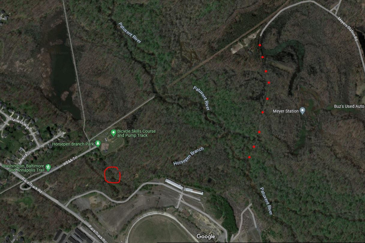
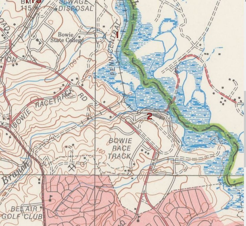
In post #11 above, I mentioned an old rickety wooden one-lane bridge dirt road across the Patuxent River back by the Bowie Racetrack I remembered from years back. I got to thinking about that and spent some time googling to see if I could uncover any references to, or old photos of that bridge. No old photos, but did find some references to it. I think it was called "Bealmears Bridge". I found a USGS topographic map from 1969 that clearly shows the bridge and it's connection across the river from the back side of the Bowie Racetrack to Meyers Station Road on AA Co side. I remember it as a double-track dirt/gravel road. On google-maps, you can see a trace of the old dirt rode on the AA Co side of the river (I added a series of red dots to highlight the old road). But no trace visible on the PG Co side leading to the site of the old single lane bridge from racetrack property.
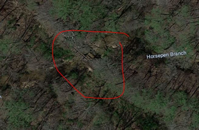
And from the google map, I can make out what looks the remains of a trestle bridge (w/ rails & ties) still remaining in the woods over Horsepen Branch (red circle). I think this is the trestle shown in a ground level photo in the Link Below. This would have been on the spur line that took trains to and from from the "Y" intersection off the main line into the racetrack. The "Y" location would have been SW (left & down) of the current location of the WSSC pumping station of google map. You can clearly see the "Y" and the old rail lines on the topo map. On the AA Co side, topo map shows the railbed of the main line, but no rails indicated. Rails on that side must have been removed when the topo map was produced in 1969.
See this webpage for details relating to the WB&A RR's main line and the ""Y" line into the racetrack: https://www.trainweb.org/oldmainline/brt1.htm
I'll have to take the dog back in there and see if anything remains of the old bridge over the river and have a closer look at that trestle bridge. You can park in Saddlebrook Park and walk onto the racetrack property easily enough. I explored the racetrack and the old grandstand area last summer with the dog.
On a sad note, the body of Donna Dustin (17 yo from Bowie) was discovered in the woods a short distance over that bridge on the AA Co side by hunters in 1973. The murder still remains unsolved.
Zoom in at trestle bridge remains? @ the red circle in the larger pic above:
Full image of 1969 topographic map can be found HERE.
Last edited by morsetaper2; 09-07-23 at 09:32 PM.
10-11-23, 01:07 PM
#18
Senior Member
Join Date: Apr 2011
Location: Maryland, USA
Posts: 2,442
Bikes: Drysdale/Gitane/Zeus/Masi/Falcon/Palo Alto/Raleigh/Legnano
Mentioned: 34 Post(s)
Tagged: 0 Thread(s)
Quoted: 987 Post(s)
Liked 641 Times
in
407 Posts
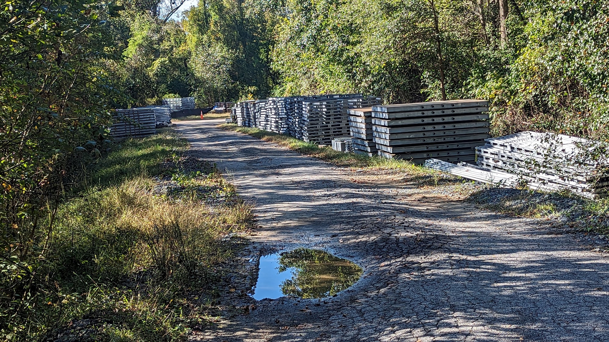
Went down from the AA side today, the pavement is so broken (by equipment?) I suspect all will need to be repaved. I found THIS on Facebook from AA county: "The contractor for the WB&A Trail Bridge over the Patuxent River has been on hold since May 2023 because Federal funding of the project, which is critical to its success, requires reviews and approvals of the manufacturing process prior to the bridge being fabricated. However, the bridge was fabricated before these reviews/approvals occurred without the knowledge of the County or State. Since May, the County, contractor, and manufacturer have been working with the SHA divisions responsible for this review and approval to identify a solution while salvaging as much of the work that was done as possible. We believe we are now nearing an agreement, and hope to be able to receive permission to continue construction sometime in November 2023. Depending on the weather, the project could be completed about 3 months after we are able to restart construction."
Yeah, it does not look promising right now:
Yeah, it does not look promising right now:
__________________
Larry:1958 Drysdale, 1961 Gitane Gran Sport, 1974 Zeus track, 1988 Masi Gran Corsa, 1974 Falcon, 1980 Palo Alto, 1973 Raleigh Gran Sport, 1974 Legnano. Susan: 1976 Windsor Profesional.
Larry:1958 Drysdale, 1961 Gitane Gran Sport, 1974 Zeus track, 1988 Masi Gran Corsa, 1974 Falcon, 1980 Palo Alto, 1973 Raleigh Gran Sport, 1974 Legnano. Susan: 1976 Windsor Profesional.
10-22-23, 11:13 AM
#20
Newbie
Join Date: Oct 2023
Posts: 4
Mentioned: 0 Post(s)
Tagged: 0 Thread(s)
Quoted: 2 Post(s)
Likes: 0
Liked 0 Times
in
0 Posts
Wb&a bridge construction. On hold
As you know, all work on this project was put on hold for 6 months (starting last May). So completion by today is a distant memory. THANKS for the update on the federal regulatory snafoo that put the project on hold. After bridge construction gets underway, they still have to create a brand new 1 mile of bike path (over the former destroyed bike path). So lots to do. Maybe by Spring??
10-24-23, 09:01 AM
#21
Senior Member
Join Date: Apr 2011
Location: Maryland, USA
Posts: 2,442
Bikes: Drysdale/Gitane/Zeus/Masi/Falcon/Palo Alto/Raleigh/Legnano
Mentioned: 34 Post(s)
Tagged: 0 Thread(s)
Quoted: 987 Post(s)
Liked 641 Times
in
407 Posts
That would be nice, no idea. I wonder if the repaving is a significant part of what's left to do? One might conclude that a mile of bike path takes less work/time/money than a mile of car-capable road, but that's conjecture on my part. I have not been there but the blocked-off part of the PG-side "spur" might also be in poor shape unless all access by equipment have been via unpaved trails behind the college? Not a fan of the chosen contractor, regardless.
__________________
Larry:1958 Drysdale, 1961 Gitane Gran Sport, 1974 Zeus track, 1988 Masi Gran Corsa, 1974 Falcon, 1980 Palo Alto, 1973 Raleigh Gran Sport, 1974 Legnano. Susan: 1976 Windsor Profesional.
Larry:1958 Drysdale, 1961 Gitane Gran Sport, 1974 Zeus track, 1988 Masi Gran Corsa, 1974 Falcon, 1980 Palo Alto, 1973 Raleigh Gran Sport, 1974 Legnano. Susan: 1976 Windsor Profesional.
10-25-23, 09:40 AM
#22
Newbie
Join Date: Oct 2023
Posts: 2
Mentioned: 0 Post(s)
Tagged: 0 Thread(s)
Quoted: 1 Post(s)
Likes: 0
Liked 0 Times
in
0 Posts
That would be nice, no idea. I wonder if the repaving is a significant part of what's left to do? One might conclude that a mile of bike path takes less work/time/money than a mile of car-capable road, but that's conjecture on my part. I have not been there but the blocked-off part of the PG-side "spur" might also be in poor shape unless all access by equipment have been via unpaved trails behind the college? Not a fan of the chosen contractor, regardless.
10-26-23, 05:13 AM
#23
Senior Member
Join Date: Apr 2011
Location: Maryland, USA
Posts: 2,442
Bikes: Drysdale/Gitane/Zeus/Masi/Falcon/Palo Alto/Raleigh/Legnano
Mentioned: 34 Post(s)
Tagged: 0 Thread(s)
Quoted: 987 Post(s)
Liked 641 Times
in
407 Posts
Agreed. I was on 700Cx28mm, not fun. Anyone get a close look at the PG side conditions?
__________________
Larry:1958 Drysdale, 1961 Gitane Gran Sport, 1974 Zeus track, 1988 Masi Gran Corsa, 1974 Falcon, 1980 Palo Alto, 1973 Raleigh Gran Sport, 1974 Legnano. Susan: 1976 Windsor Profesional.
Larry:1958 Drysdale, 1961 Gitane Gran Sport, 1974 Zeus track, 1988 Masi Gran Corsa, 1974 Falcon, 1980 Palo Alto, 1973 Raleigh Gran Sport, 1974 Legnano. Susan: 1976 Windsor Profesional.
10-26-23, 06:14 PM
#24
Newbie
Join Date: Oct 2023
Posts: 2
Mentioned: 0 Post(s)
Tagged: 0 Thread(s)
Quoted: 1 Post(s)
Likes: 0
Liked 0 Times
in
0 Posts
latest update from Friends of Anne Arundel CO Trail.:
Hi, Jim -- I have more recent info on the bridge. The county is now saying it could be February before the bridge is completed and opened. Sorry. Know you are anxious.
Diane R. Evans
President, FOAACT
01-14-24, 03:55 PM
#25
Newbie
Join Date: Oct 2023
Posts: 4
Mentioned: 0 Post(s)
Tagged: 0 Thread(s)
Quoted: 2 Post(s)
Likes: 0
Liked 0 Times
in
0 Posts
Bridge connecting WB&A Trail
No progress on the bridge since May 2023 and it's now mid-January. It would be unfortunate for Anne Arundel to cancel this major bikeway connector project after millions spent (and a couple miles of the trail destroyed). But we can hope it will be resurrected. Does anyone have news? The county is very silent.