


Glen's Sierra/Welch/Morrison Ride Report 2/21
 02-23-09, 01:25 PM
#26
Senior Member

Join Date: Jun 2007
Location: Los Gatos, CA
Posts: 888
Bikes: 2006 Cannondale Synapse carbon 2
Mentioned: 0 Post(s)
Tagged: 0 Thread(s)
Quoted: 1 Post(s)
Likes: 0
Liked 0 Times
in
0 Posts
Get a couple more bungees and maybe you can start delivering pizzas on the side for a little extra cash 
 02-23-09, 01:27 PM
#27
Senior Member

Join Date: Jan 2005
Location: Bay Area CA
Posts: 1,080
Mentioned: 0 Post(s)
Tagged: 0 Thread(s)
Quoted: 3 Post(s)
Likes: 0
Liked 0 Times
in
0 Posts
. It would be nice to have that 11 on the downhills.
02-23-09, 01:32 PM
#28

Dolce far niente

Join Date: Dec 2004
Location: Northern CA
Posts: 10,704
Mentioned: 15 Post(s)
Tagged: 0 Thread(s)
Quoted: 20 Post(s)
Likes: 0
Liked 17 Times
in
14 Posts
This one pretty much tells me everything I need to know about Welsh Creek. Tell me, though - is it a dead-end? How many miles from start of Welsh Creek intersection to top?

__________________
"Love is not the dying moan of a distant violin, it�s the triumphant twang of a bedspring."
S. J. Perelman
"Love is not the dying moan of a distant violin, it�s the triumphant twang of a bedspring."
S. J. Perelman
02-23-09, 01:39 PM
#30
Senior Member
Join Date: Jan 2005
Location: Bay Area CA
Posts: 1,080
Mentioned: 0 Post(s)
Tagged: 0 Thread(s)
Quoted: 3 Post(s)
Likes: 0
Liked 0 Times
in
0 Posts
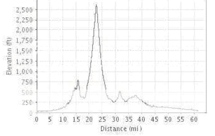
* Welch Creek Rd (4.1 miles, 1910 ft, 8.8%)
Welch Creek Road is not known to many cyclists, particularly on the Peninsula. The reason is twofold. First, the climb is away from civilization, in the Sunol Regional Wilderness in the East Bay. It's off of Calaveras a few miles past the 680 underpass, right before Calaveras itself starts climbing, at the place known as Haynes Gulch, flanked to the left by Apperson Ridge with its mighty Maguire Peaks (trail to the top is at 0.72 mi mark, but no bikes are allowed on that trail). Second, many bruised souls conceal their traumatic experiences with this long climb. It's a monster that will grind you to the bone, will turn your quads to jelly, will bake you in the cruel sun or envelope in wintry fog. The difficulty of its narrow one lane with abrasive pavement, and inconsistent gradient is tempered by the views and sounds of the creek (in the winter), and open skies and pastures at the top but accentuated by frequent (four or five total) cattleguards. Sunol Regional Park stretches from 0.3 to 2.8 mile markers. Within the park, a stretch of road between 2.0 and 2.5 mile markers is bloody steep, in excess of 15%. Above 2.8 mark, the road emerges from the canyon and becomes steeper again, bloody steeper. By the finish the gradient is truly bloody relentless. Views towards the bay could be tremendous. See also here. Net climbing is only about 1900 ft but will all the ups and downs you'll end up climbing 2265 ft, which would produce 10.7% average grade. Vultures are ready to pick on your exhausted meat, I mean muscles. You can also see acorn woodpecker, black phoebe, titmouse, yellow-billed magpie and turkey vulture. Did I mention it is long (and that's only to the end of paved section, dirt segment continues far beyond, as a bike legal dirt fire road for another 3.4 miles towards Rose Peak (which itself is only 36 ft lower than Mt. Diablo) but much less steeply, and "No Motor Vehicles" signs could obviously be ignored) and illegal beyond the border of Ohlone Wilderness? Since there are multiple cattleguards on steep stretches, caution and good brake pads are advised when descending. For the daring ... Update: Sometime in 2007 the road was repaved and asphalt is pristine - Enjoy! [Aerial Photo]
02-23-09, 01:49 PM
#31
Polypedalous
Join Date: Mar 2006
Location: redwood city
Posts: 209
Bikes: Bianchi, Benotto, Rocky Mountain, Merlin
Mentioned: 0 Post(s)
Tagged: 0 Thread(s)
Quoted: 0 Post(s)
Likes: 0
Liked 0 Times
in
0 Posts
My gearing set-up is mostly by chance since my bike came with the regular 53-39 and the least expensive way to get more gears was buying a MtB cassette (and I frugally with crossed fingers kept the original short-cage rear derailleur). But I really like the setup. The 39-32 definitely allows for climbing steep pitches. 53 gives a little extra on the mild descents. And finally, when your front derailleur cable breaks, you have a 39 instead of a 34 which is crucial for motoring along on the flats behind the Marco/Ruth express.
02-23-09, 01:49 PM
#32
Senior Member
Join Date: Jan 2005
Location: Bay Area CA
Posts: 1,080
Mentioned: 0 Post(s)
Tagged: 0 Thread(s)
Quoted: 3 Post(s)
Likes: 0
Liked 0 Times
in
0 Posts
And yes, it is a dead-end (though there is a dirt road that continues going up). The climb itself is beautiful and feels pretty isolated. It's brutal, and gets harder toward the top. The descent is fun, but fairly technical as it is not a wide road and it's curvy, making it tough to see cars coming up.
02-23-09, 07:09 PM
#34
Tandem Mountain Climber
Join Date: Mar 2007
Location: San Mateo, CA
Posts: 4,104
Bikes: Calfee Tandem, Litespeed Gravel, SuperSix Evo HM, Larry vs. Harry Bullitt (e-cargo)
Mentioned: 0 Post(s)
Tagged: 0 Thread(s)
Quoted: 1 Post(s)
Likes: 0
Liked 3 Times
in
1 Post
 Your cadence must have been Gerbil speed for sure.
I was going between basically 24-30 mph that entire stretch of Niles Canyon (mostly around 27-ish).
02-23-09, 10:45 PM
#35
DoubleTrouble
Join Date: Dec 2006
Location: Vacaville, CA
Posts: 599
Bikes: 06 Co-Motion Tandem, Fuji Team Pro mine,-Hers, Specialized Dolce
Mentioned: 0 Post(s)
Tagged: 0 Thread(s)
Quoted: 0 Post(s)
Likes: 0
Liked 0 Times
in
0 Posts
Looks like you are ready for Mix canyon. Here is the description.
Mix
 A view from just above Mix Canyon lookout around mile marker 4.0
We've all seen the Vaca Mountains to the west of Davis. If you've particularly good eyesight (or binoculars), you'll see a collection of antennas near the top of the highest of these mountains. Reputedly one of the steepest paved roads in the continental United States, Mix Canyon Road climbs to these antennas. The low point is at 358 feet, the "summit" is 2717 feet for an approximate average grade of 9% for the whole climb. The five mile climb gets progressively steeper, topping out at a 23% grade (between mile markers 4.3 and 4.4) near the top. Some have likened the climb to the famed Alpe d'Huez of the Tour de France (which is twice the distance but "only" reaches a 14% grade). Mix Canyon Road begins at Pleasants Valley Road just south of Cantelow and a bit north of Vacaville. Much of the climb is half forested along a boulder-strewn stream. The first 3.5 miles is relatively easy (relatively!). Unless you've a red polka-dotted jersey somewhere in your closet, you may want to take these miles easy. The first landmark thereafter is known as "two houses". After that you'll climb to a guardrail and a vista where you'll finally see the radio antennas. Once you see these antennas, know that you're almost at the top, so keep going! As the grade of the road eases off, there is a fork in the road. The left is gated and the right a graded gravel road, continue right several hundred yards to gain the high point of the road. From here on a clear day you can see from the Sierra high country to the east, and to the west; Mt. Tam and the north and south towers of the Golden Gate Bridge. Believe it or not, this is not a very fun downhill ride. The road is too steep and twisted to coast for very far without braking. Stopping at the guard rail for the view and a moment to cool your rims is recommended. Traffic is scant here, but drivers are usually using the whole width of the road. The road is seldom wider than twelve feet, is a bit rough in places and the lower miles are often damp. All of these factors coupled with LSD (that's limited sight distance) make for a very heads up descent. If you start out from Davis, you'll have ridden about 60 miles once you get back. By the way, this is a way, way beyond-category climb. Weighted bragging rights: one minute ascent time per year of age. Good Luck!
This ride is about 10 miles from our house. I have only done it once and it will definitely get your attention. Most people only ride it to the 3.5 mile mark. The last section takes you about a thousand feet in around 1.5 miles. The descent is tough. There is no way to coast any distance at all because of all the tight turns on a very narrow road.
Come on up and give it a try some time.[IMG]file:///C:/DOCUME%7E1/CDG/LOCALS%7E1/Temp/moz-screenshot.jpg[/IMG]
Mix
 A view from just above Mix Canyon lookout around mile marker 4.0
 We've all seen the Vaca Mountains to the west of Davis. If you've particularly good eyesight (or binoculars), you'll see a collection of antennas near the top of the highest of these mountains. Reputedly one of the steepest paved roads in the continental United States, Mix Canyon Road climbs to these antennas. The low point is at 358 feet, the "summit" is 2717 feet for an approximate average grade of 9% for the whole climb. The five mile climb gets progressively steeper, topping out at a 23% grade (between mile markers 4.3 and 4.4) near the top. Some have likened the climb to the famed
Alpe d'Huez of the Tour de France (which is twice the distance but "only" reaches a 14% grade). Mix Canyon Road begins at Pleasants Valley Road just south of Cantelow and a bit north of Vacaville. Much of the climb is half forested along a boulder-strewn stream. The first 3.5 miles is relatively easy (relatively!). Unless you've a red polka-dotted jersey somewhere in your closet, you may want to take these miles easy. The first landmark thereafter is known as "two houses". After that you'll climb to a guardrail and a vista where you'll finally see the radio antennas. Once you see these antennas, know that you're almost at the top, so keep going! As the grade of the road eases off, there is a fork in the road. The left is gated and the right a graded gravel road, continue right several hundred yards to gain the high point of the road. From here on a clear day you can see from the Sierra high country to the east, and to the west; Mt. Tam and the north and south towers of the Golden Gate Bridge. Believe it or not, this is not a very fun downhill ride. The road is too steep and twisted to coast for very far without braking. Stopping at the guard rail for the view and a moment to cool your rims is recommended. Traffic is scant here, but drivers are usually using the whole width of the road. The road is seldom wider than twelve feet, is a bit rough in places and the lower miles are often damp. All of these factors coupled with LSD (that's limited sight distance) make for a very heads up descent. If you start out from Davis, you'll have ridden about 60 miles once you get back. By the way, this is a way, way beyond-category climb. Weighted bragging rights: one minute ascent time per year of age. Good Luck! This ride is about 10 miles from our house. I have only done it once and it will definitely get your attention. Most people only ride it to the 3.5 mile mark. The last section takes you about a thousand feet in around 1.5 miles. The descent is tough. There is no way to coast any distance at all because of all the tight turns on a very narrow road.
Come on up and give it a try some time.[IMG]file:///C:/DOCUME%7E1/CDG/LOCALS%7E1/Temp/moz-screenshot.jpg[/IMG]
