


Cellular elevation gain accuracy
 04-07-22, 11:59 AM
#26
Tragically Ignorant

Join Date: Jun 2018
Location: New England
Posts: 15,613
Bikes: Serotta Atlanta; 1994 Specialized Allez Pro; Giant OCR A1; SOMA Double Cross Disc; 2022 Allez Elite mit der SRAM
Mentioned: 62 Post(s)
Tagged: 0 Thread(s)
Quoted: 8186 Post(s)
Liked 9,098 Times
in
5,054 Posts
Yes, just so. I only mentioned noise because you brought it up initially. Coordinates and elevation are a reasonably qualitative match when compared to the lake depth chart. I could not find a way to download the actual data from MMR, though.
I think there is a definite relationship to the underwater topography. I'll do some testing on my next visit to the lake.
I think there is a definite relationship to the underwater topography. I'll do some testing on my next visit to the lake.
You being in North Carolina, might be more fun to MapMyFerryRide. Maybe you'll find a shipwreck or something.
 04-07-22, 03:17 PM
#27
astro
Join Date: Mar 2006
Location: Pennington, NJ
Posts: 355
Bikes: Raleigh Sports, '72, Bianchi Volpe, '97 (no more, it died), Greenspeed GTVS6, '05, Trek 520, '13
Mentioned: 2 Post(s)
Tagged: 0 Thread(s)
Quoted: 43 Post(s)
Likes: 0
Liked 51 Times
in
25 Posts
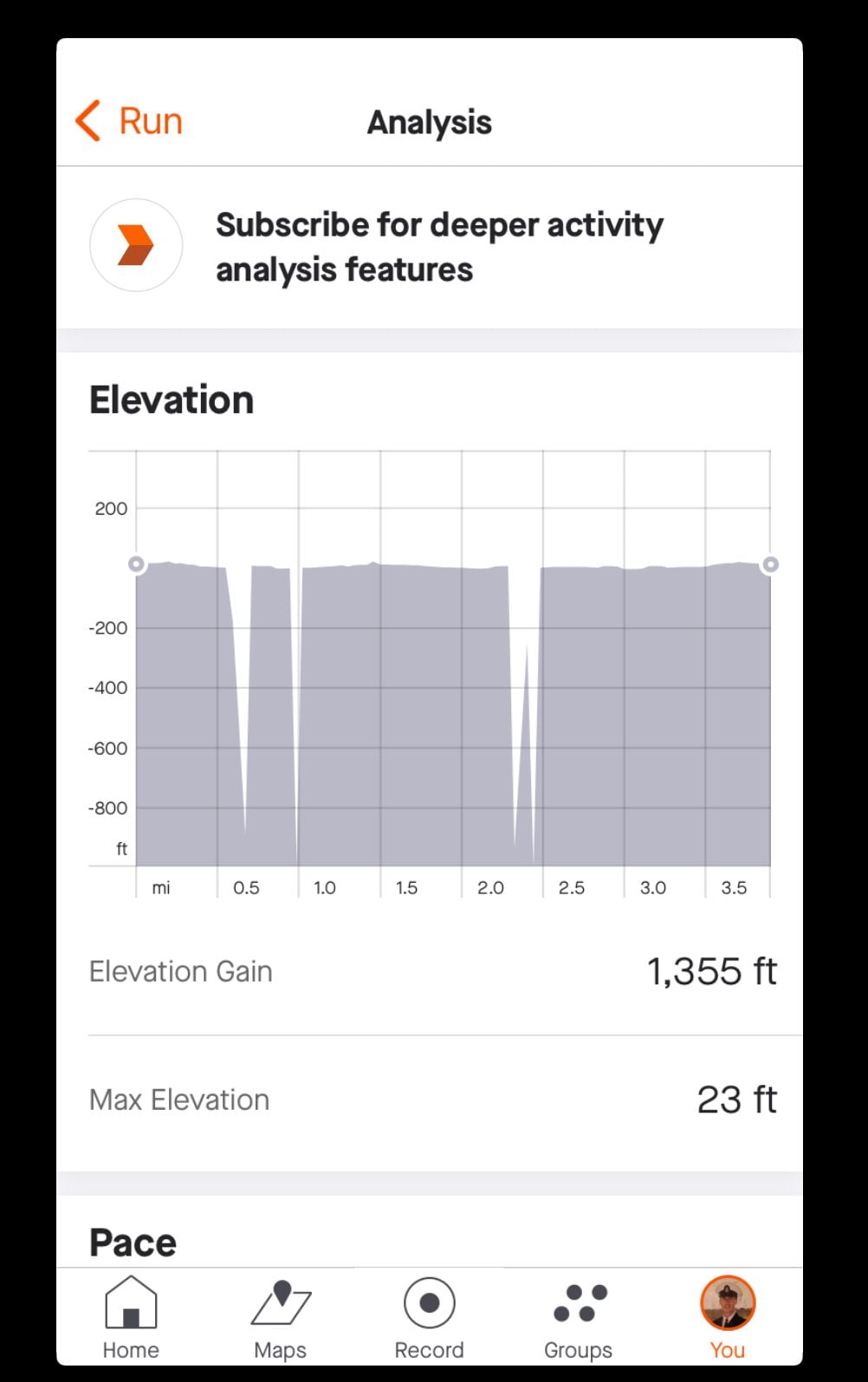
I think that irregularities like this are due to glitches in the proprietary software of the fitness app. Here�s why I think that. Attached is the screenshot of the elevation profile from a run I did in 2019 along the beach at a resort in Punta Cana, D.R. And I mean I jogged right along the water�s edge so there were no hills. But, for the 4-mile jog along the water there�s a total of 1355 feet of elevation. You�ll notice that at a couple places on the profile it goes from ZERO feet elevation way down to more than negative 900 feet in the space of just a couple hundred yards. I did this particular run to see if it would mimic the same irregularity from the previous year�that unfortunately I didn�t notice until we�d returned home from the vacation. Sure enough�it made the same exact elevation plunge in the same exact place as it did the previous year. And I can assure you there wasn�t a �Grand Canyon� there on the beaches of the D.R. that I fell into. This activity was recorded with my iPhone using the Strava app. When I made this investigative run the second year, I also wore a Garmin GPS watch. When I looked at the elevation profile on the Garmin�there were no erratic elevation plunges, just normal elevation for a jog along the beach. So either there was/is some glitch in the Strava software, or software that Strava uses�or there is some sort of electromagnetic disturbance right at that particular spot that causes the cell phone�s GPS reception to go haywire. But then again it�s probably NOT that because �GPS reception is GPS reception� regardless of the device. So it must be in a software algorithm.
FWIW�I have a friend currently living in the Pensacola, FL area. On one of his regular cycling routes he�s experiencing a similar occurrence. He�s riding along road adjacent to the waterfront. No bridges or overpasses. But at one point (same place every time) it shows him going up/down a hill of about 250 feet in the space of less than 100 yards.� Dan
FWIW�I have a friend currently living in the Pensacola, FL area. On one of his regular cycling routes he�s experiencing a similar occurrence. He�s riding along road adjacent to the waterfront. No bridges or overpasses. But at one point (same place every time) it shows him going up/down a hill of about 250 feet in the space of less than 100 yards.� Dan
04-08-22, 09:25 AM
#28
Sr Member on Sr bikes

Dan
04-08-22, 06:03 PM
#29
Half way there
Thread Starter

Join Date: Sep 2015
Location: North Carolina
Posts: 2,958
Bikes: Many, and the list changes frequently
Mentioned: 5 Post(s)
Tagged: 0 Thread(s)
Quoted: 989 Post(s)
Liked 881 Times
in
528 Posts
Even the page from MMR. There's some way of exporting the ride.
It's common in "debugging" situations that people only report the information they think is important. I like to see "everything" because what people think is important often isn't.
It seems like that's the most likely explanation. Maybe, the lake was a reservoir? I don't know if the orbital scans of topography read water surface or not.
Well I was finally able to figure out how to download a tcx file, but it took a bit of doing to convert to csv. The data show a baseline of 74 meters, corresponding to when I was in the middle of the lake, rising to 98 meters at a point close to shore. Since the nominal lake level above stream bed is 28 meters, this seems to match my experience. Yes, the lake is a reservoir. I could probably upload the csv file if you want to take a look.
No one uses these to determine elevation gain on flat water. It's not too surprising that this use-case doesn't work very well.
Thanks
04-08-22, 06:07 PM
#30
Senior Member
Join Date: Sep 2007
Location: Far beyond the pale horizon.
Posts: 14,278
Mentioned: 31 Post(s)
Tagged: 0 Thread(s)
Quoted: 4260 Post(s)
Liked 1,364 Times
in
945 Posts
Well I was finally able to figure out how to download a tcx file, but it took a bit of doing to convert to csv. The data show a baseline of 74 meters, corresponding to when I was in the middle of the lake, rising to 98 meters at a point close to shore. Since the nominal lake level above stream bed is 28 meters, this seems to match my experience. Yes, the lake is a reservoir. I could probably upload the csv file if you want to take a look.
Bingo.
Thanks
Bingo.
Thanks
04-11-22, 05:33 PM
#31
Half way there
Thread Starter
Join Date: Sep 2015
Location: North Carolina
Posts: 2,958
Bikes: Many, and the list changes frequently
Mentioned: 5 Post(s)
Tagged: 0 Thread(s)
Quoted: 989 Post(s)
Liked 881 Times
in
528 Posts
I was able to find a Linux version of GPXsee and agree that it is nice. So I had another row today in a deeper part of the lake. For the most part, the elevation was stable except when, at a mile into the row, I decided to beach the boat in a sandy area where the terrain rises quickly away from the lake. Also today, I started and stopped the app at the same place (both elevations match). I think it's clear that there is a rather loose relationship between elevation and closeness to shore; however I've pretty much abandoned my curiosity about it. I've attached the tcx files in case anyone wants to take a look.
