


Hwy 39 to Wrightwood
 01-06-10, 01:04 PM
#1
Senior Member
Thread Starter
Join Date: Nov 2009
Posts: 104
Mentioned: 0 Post(s)
Tagged: 0 Thread(s)
Quoted: 0 Post(s)
Likes: 0
Liked 0 Times
in
0 Posts
Hwy 39 to Wrightwood
I plan to do this ride next this coming late spring. Although I have never ridden a true century, I am pretty sure I could pull one off now. This, however, is 100 miles in the mountains. Most of the climbing will be in the first half but still this is daunting. I half thought about spending the night in Wrightwood, but I would really like to do it in one day. FWIW, I have ridden most of 39 in the past, but never on the 2 to Wrightwood.
Anyone done it? Any stories you would like to share or advice? Greatly appreciated.
Edit: If indeed the ToC passes along here, maybe I will try and do it then. May 21. Maybe we could could a group going.
Anyone done it? Any stories you would like to share or advice? Greatly appreciated.
Edit: If indeed the ToC passes along here, maybe I will try and do it then. May 21. Maybe we could could a group going.
Last edited by bigtempo; 01-06-10 at 01:11 PM.
 01-06-10, 08:31 PM
#2
Senior Member
Join Date: Sep 2005
Location: In the foothills of Los Angeles County
Posts: 25,290
Mentioned: 8 Post(s)
Tagged: 0 Thread(s)
Quoted: 8279 Post(s)
Liked 9,038 Times
in
4,475 Posts
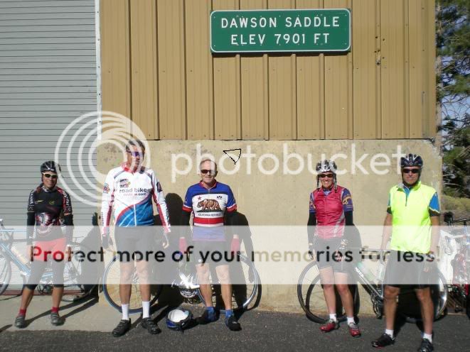
After you get to the 2 there is a six-ish mile climb of about 1000 feet. That's Dawson Saddle. From the bottom of 39 you have gained over 7000 feet, then comes a six-ish mile descent to Vincent Gap, then a 3ish mile climb to Inspiration Point, then a 7ish mile descent into Wrightwood. Leaving Wrightwood to go back you face a couple thousand feet of climbing to get back to Dawson Saddle and the steepest part is just outside of Wrightwood, but you do go back up to 7900 feet elevation, so you may notice the thin air.
There is a little climbing on 39 near the bottom, too.
There is a little climbing on 39 near the bottom, too.
Last edited by big john; 01-06-10 at 08:39 PM. Reason: add pic
01-07-10, 12:52 AM
#3

Mostly Mischief

Big John, thanks for the breakdown of the route east from Islip. When I got up there yesterday, via 39, I contemplated going back on Angeles Crest, but westwards to Pasadena and then on to Azusa. But I didn't, not wanting to get lost in the neighborhoods of Arcadia etc, without prior research.
How much additional gain is involved in the return trip west from Islip saddle?
Here's some pics from yesterdays ride to Highway 2 up 39:


How much additional gain is involved in the return trip west from Islip saddle?
Here's some pics from yesterdays ride to Highway 2 up 39:
Last edited by jan nikolajsen; 01-07-10 at 10:48 AM.
01-07-10, 03:17 PM
#5
Senior Member
Join Date: Sep 2005
Location: In the foothills of Los Angeles County
Posts: 25,290
Mentioned: 8 Post(s)
Tagged: 0 Thread(s)
Quoted: 8279 Post(s)
Liked 9,038 Times
in
4,475 Posts
Jan, going west from Islip there is some climbing but nothing too hard. I'm not sure of the total but it would be at least 1000 feet from Islip to Cloudburst Summit, then another 800 feet from Newcomb Ranch to Red Box and a couple hundred between Red Box and Clear Creek. From the bottom of AC it's pretty easy to get back to the area of Hwy 39 and Sierra Madre. I can't give you the turns off the top of my head but I probably have it written down at home somewhere.
01-07-10, 06:52 PM
#6
A Mountaineering thing

Join Date: Oct 2004
Location: Under Mt Baldy in Glendora,California
Posts: 848
Bikes: 4 Road 2 Mtn
Mentioned: 0 Post(s)
Tagged: 0 Thread(s)
Quoted: 0 Post(s)
Likes: 0
Liked 0 Times
in
0 Posts
Jan, That must have been you I saw heading down, about a mile below me not too far below the Crystal Lake turnoff. I was stopped to take pictures of the switchbacks below when I saw a rider that I first thought was the guy I was with, until I realized Mr. Beanz could not have gotten that far down the road in such little time. You got some nice pics. What do you think, was the weather just about perfect up there yesterday?
01-07-10, 07:50 PM
#7
Banned.

Join Date: Dec 2005
Location: Upland Ca
Posts: 19,895
Bikes: Lemond Chambery/Cannondale R-900/Trek 8000 MTB/Burley Duet tandem
Mentioned: 0 Post(s)
Tagged: 0 Thread(s)
Quoted: 0 Post(s)
Likes: 0
Liked 4 Times
in
3 Posts
Jan, That must have been you I saw heading down, about a mile below me not too far below the Crystal Lake turnoff. I was stopped to take pictures of the switchbacks below when I saw a rider that I first thought was the guy I was with, until I realized Mr. Beanz could not have gotten that far down the road in such little time. You got some nice pics. What do you think, was the weather just about perfect up there yesterday?

Thread
Thread Starter
Forum
Replies
Last Post
Seattle Forrest
Pacific Northwest
13
06-23-12 01:41 AM
rallison
Southern California
33
10-23-10 07:43 PM
rallison
Southern California
17
06-26-10 11:48 AM
