


Yet another GPS thread.
 12-05-05 | 01:00 PM
#1

Thread Starter
Senior Member
Joined: Aug 2005
Posts: 417
Likes: 0
From: Kodiak, Alaska
Yet another GPS thread.
What GPS would you recommend for a tandem team that doesn't need mapping functions, but wants the speed, distance, time, altitude, etc. available to them, and available for downloading into a computer?
We are looking at the Garmin GPS60, and I have an old GPS12 that I might use, although the altitude readings are questionable at best on that one.
Any suggestions?
Thanks!
We are looking at the Garmin GPS60, and I have an old GPS12 that I might use, although the altitude readings are questionable at best on that one.
Any suggestions?
Thanks!
 12-05-05 | 02:48 PM
#2
Senior Member
Joined: Nov 2004
Posts: 66
Likes: 0
I have recently done some research and found out that one of the Garmin-units is the case. However they have a problem around the track point limit of 10.000 which means you need a possibility of downloading parts of your long distance tour along the route. That�s really a problem if you don�t have a laptop with you on the bike 
The unit I first decided to buy was Garmin eTrex Vista C - it include Compass too. As you say, you need not the mapping functions. Then I think you should take a look at Edge 305 - https://www.garmin.com/products/edge305/
Garmin has increased the track points to 13.000 - Great but it can be even better! However, you didn�t want that but I think they have developed the unit especially for biking with all the features we like to use - but believe it or not it�s without the Compass - I�m really surprised.
12-05-05 | 05:25 PM
#4

Every day a winding road
Joined: Mar 2005
Posts: 6,538
Likes: 63
From: Pittsburgh, PA
Bikes: 2005 Cannondale SR500, 2008 Trek 7.3 FX, Jamis Aurora
I have the GpsMap 76C and I am satified with it, but have yet to use it on any long distance tour. It is classified as a Marine GPS but will work well on a bike.
I would consider the Quest 2 but it's rechargable battery pack does not make it a good canidate for touring. But it's shape seems to make it a better fit for the handle bars. Plus it has voice prompts, but you would have to mount a
speaker
I would consider the Quest 2 but it's rechargable battery pack does not make it a good canidate for touring. But it's shape seems to make it a better fit for the handle bars. Plus it has voice prompts, but you would have to mount a
speaker
12-05-05 | 06:22 PM
#5
Walmart bike rider

Joined: Aug 2004
Posts: 2,131
Likes: 34
From: South Carolina
Geko 201 doesn't come with the cable. That's another 25-30 bucks. By the time you add the cost of the cable, the Legend is about the same price.
If you don't want mapping, the GPS 60 is way overpriced by what you need.
If you want a real barometic altimeter, then you'll need either the Geko 301, Etrex Vista or the Garmin Venture if you can find it. I find the GPS barometer to be fine with me which any unit will have.
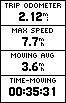
I would recommend the Etrex Legend (around 150 bucks) and it comes with the data cable. It's a very popular unit. Although you don't want mapping, these cheap unit just happens to come with a base map. It also has something the Geko and Etrex Yellow doesn't have and that is a data screen that can track up to 8 fields at one time. I find that to be the most feature myself. At the bottom is a screen shot from the Legend Color but it is identical to the Legend BW. You can change it to bigger numbers if you want.
Magellan makes the Explorist series which also will have some of the features you want. The 210 is probably the unit that is closest to your needs.
Websites that can help you.
https://www.garmin.com
https://www.magellangps.com
https://www.lowrance.com

If you don't want mapping, the GPS 60 is way overpriced by what you need.
If you want a real barometic altimeter, then you'll need either the Geko 301, Etrex Vista or the Garmin Venture if you can find it. I find the GPS barometer to be fine with me which any unit will have.
I would recommend the Etrex Legend (around 150 bucks) and it comes with the data cable. It's a very popular unit. Although you don't want mapping, these cheap unit just happens to come with a base map. It also has something the Geko and Etrex Yellow doesn't have and that is a data screen that can track up to 8 fields at one time. I find that to be the most feature myself. At the bottom is a screen shot from the Legend Color but it is identical to the Legend BW. You can change it to bigger numbers if you want.
Magellan makes the Explorist series which also will have some of the features you want. The 210 is probably the unit that is closest to your needs.
Websites that can help you.
https://www.garmin.com
https://www.magellangps.com
https://www.lowrance.com
12-05-05 | 08:37 PM
#7
Banned.
Joined: Aug 2001
Posts: 616
Likes: 0
I have the Etrex Legend as well. It is accurate in altitude everywhere I've hiked. It doesn't use a barometer to measure altitude, it measures from the satellites. I'm sure of this because the unit is accurate in alititude even on pressurized airplanes, at least up to 33k feet or so. (Though Garmin says the Legend isn't designed to measure airplane speeds, it does. It displayed 525 mph ground speed on the plane.)
The base map on the Legend is nice, too, as long as you're on the right continent. There's a bar mount for the Legend that works fine, too, though I'd advise some rubber between it and the bar if you can fit it. It will dampen the vibrations.
The little nubby stick doesn't always work. Otherwise, it's a good unit.
12-05-05 | 09:24 PM
#9
Walmart bike rider
Joined: Aug 2004
Posts: 2,131
Likes: 34
From: South Carolina
Luke,
Maybe it was me but I had a bad experience in buying those home-made serial cable kits, it didn't work. The GEKO only allows you to view 1 data field at one time, the Legend 8 data fields at one time. Photos of each data field is included.

GEKO, you can change the bottom field to what you want but you can only view ONE field at a time.
With the Legend, you can view 8 at time one.
Maybe it was me but I had a bad experience in buying those home-made serial cable kits, it didn't work. The GEKO only allows you to view 1 data field at one time, the Legend 8 data fields at one time. Photos of each data field is included.
GEKO, you can change the bottom field to what you want but you can only view ONE field at a time.
With the Legend, you can view 8 at time one.
 12-06-05 | 09:37 AM
#12
Senior Member
Joined: Jan 2005
Posts: 156
Likes: 0
I dunno man,
I used the gecko 201 in the field summer, and you can get the multipane trip computer display w/ custimizable fields... you can even get it to do UTM/latlon simultaenously.
As for the net cables.. there's more than one distributor, i've got a 12V power/serial cable from mrplace on ebay. Works great.Total cost was about 10-15$ with shipping.
I mean its not the greatest GPS but its inexpensive, totally waterproof (unlike the Etrex series where the batt compartment isnt really waterproof) and very light - though batt lfie is about the same as the etrex's
12-06-05 | 12:37 PM
#13
Senior Member
Joined: Jul 2004
Posts: 185
Likes: 0
I'm pretty excited about the new Garmin Edge 305. The manual has recently been posted on-line at:
https://www.garmin.com/manuals/967_OwnersManual.pdf
https://www.garmin.com/manuals/967_OwnersManual.pdf
12-06-05 | 12:43 PM
#14

Mad bike riding scientist


Joined: Nov 2004
Posts: 29,137
Likes: 6,186
From: Denver, CO
Bikes: Some silver ones, a red one, a black and orange one, and a few titanium ones
Originally Posted by RiotBoi
sextant.
 Personally, I prefer the Thataway method of navigation.
__________________
Stuart Black
Dreamin' of Bemidji Down the Mississippi (in part)
Plan Epsilon Around Lake Michigan in the era of Covid
Gold Fever Three days of dirt in Colorado
Pokin' around the Poconos A cold ride around Lake Erie
Dinosaurs in Colorado A mountain bike guide to the Purgatory Canyon dinosaur trackway
Solo Without Pie. The search for pie in the Midwest.
Picking the Scablands. Washington and Oregon, 2005. Pie and spiders on the Columbia River!
12-06-05 | 10:43 PM
#16
Senior Member
Joined: Mar 2005
Posts: 243
Likes: 0
From: Joliet, IL
I have the Garmin eTrex Legend C gps bundle pack that comes with topo USA software since a couple days before halloween and i love using it. Map features will be more useful to me when I get the City Select or Navigator software. For now, I use the topo software which probably isn't too useful where i live. It helps me a lot as far as making maps go (especially new trails not on most aerial maps.).
12-07-05 | 09:23 AM
#17
Mad bike riding scientist
Joined: Nov 2004
Posts: 29,137
Likes: 6,186
From: Denver, CO
Bikes: Some silver ones, a red one, a black and orange one, and a few titanium ones
Originally Posted by RiotBoi
I usually use the Dun-Dee method. *glances up* It's over there, half a day.

__________________
Stuart Black
Dreamin' of Bemidji Down the Mississippi (in part)
Plan Epsilon Around Lake Michigan in the era of Covid
Gold Fever Three days of dirt in Colorado
Pokin' around the Poconos A cold ride around Lake Erie
Dinosaurs in Colorado A mountain bike guide to the Purgatory Canyon dinosaur trackway
Solo Without Pie. The search for pie in the Midwest.
Picking the Scablands. Washington and Oregon, 2005. Pie and spiders on the Columbia River!
Stuart Black
Dreamin' of Bemidji Down the Mississippi (in part)
Plan Epsilon Around Lake Michigan in the era of Covid
Gold Fever Three days of dirt in Colorado
Pokin' around the Poconos A cold ride around Lake Erie
Dinosaurs in Colorado A mountain bike guide to the Purgatory Canyon dinosaur trackway
Solo Without Pie. The search for pie in the Midwest.
Picking the Scablands. Washington and Oregon, 2005. Pie and spiders on the Columbia River!
12-07-05 | 12:51 PM
#18
Walmart bike rider
Joined: Aug 2004
Posts: 2,131
Likes: 34
From: South Carolina
Originally Posted by luke.harrison
I dunno man,
I used the gecko 201 in the field summer, and you can get the multipane trip computer display w/ custimizable fields... you can even get it to do UTM/latlon simultaenously.the etrex's
I used the gecko 201 in the field summer, and you can get the multipane trip computer display w/ custimizable fields... you can even get it to do UTM/latlon simultaenously.the etrex's

There's like 30 fields you can choose from in both the Geko and the Legend to display.
 12-07-05 | 01:20 PM
#19
Senior Member
Joined: Jan 2005
Posts: 156
Likes: 0
You make a good point, the legend (actually I own the legend, but have used the Gecko) is by far a better deal if you want mapping.
However, if you dont want mapping the gecko is much lighter and simpler and fully waterproof..
Its a matter of priorities
Personally, I prefer the legend, but the gecko is a solid choice too, especially coupled with a laptop for mapping (for a car for ex.)
However, if you dont want mapping the gecko is much lighter and simpler and fully waterproof..
Its a matter of priorities
Personally, I prefer the legend, but the gecko is a solid choice too, especially coupled with a laptop for mapping (for a car for ex.)
 12-07-05 | 11:15 PM
#21
Walmart bike rider
Joined: Aug 2004
Posts: 2,131
Likes: 34
From: South Carolina
Originally Posted by luke.harrison
However, if you dont want mapping the gecko is much lighter and simpler and fully waterproof..
For hiking, I would prefer the Geko 201 or 301 for the lesser weight and smaller batteries. Those 2 ounces might not seem much but for long distance hiking, it adds up. I would have to get used to the keys not being on the side and I would miss my joystick.
The units I would love to get a good review on are the Magellan Explorist 210 and the Lowrance H20 from someone who actually uses them for bicycling.
12-08-05 | 04:25 AM
#22
Senior Member
Joined: Nov 2004
Posts: 66
Likes: 0
Originally Posted by gpsblake
The units I would love to get a good review on are the Magellan Explorist 210 and the Lowrance H20 from someone who actually uses them for bicycling.
Magellan eXplorist 210 GPS that: "Stores up to 380 files, each containing 500 waypoints"
Does that mean I can, let�s say go on a tour lasting 4 mounths and then apart it during the tour into fx 20 files each containing 500 tracked waypoints. Then back home I will be able to put all the files together on the map?
If that�s possible I think it will solve my problems on long distance touring. Anyway no Garmin-units are able to do so. However 500 x 380 equal to 19000 waypoints compared to Garmins 10000 makes a great difference.
Can you or anybody explain or confirm above? Thank you!
12-08-05 | 06:07 PM
#23
Walmart bike rider
Joined: Aug 2004
Posts: 2,131
Likes: 34
From: South Carolina
Per Kuhlwein,
500 x 380 = 190,000 not 19,000...... Which would be awesome indeed!!!
I've haven't had a chance to see a 210 yet but going by the specs, it seems to be an amazing unit for around 140 bucks and comes with cable and 20 MEGS of memory.
The geocaching forum is probably far and away the best source of information on GPS units. Those guys eat and sleep with their GPS units.
https://forums.groundspeak.com/gc/
I going to link your question to their forum and see what they have to say.
500 x 380 = 190,000 not 19,000......
Which would be awesome indeed!!!I've haven't had a chance to see a 210 yet but going by the specs, it seems to be an amazing unit for around 140 bucks and comes with cable and 20 MEGS of memory.
The geocaching forum is probably far and away the best source of information on GPS units. Those guys eat and sleep with their GPS units.
https://forums.groundspeak.com/gc/
I going to link your question to their forum and see what they have to say.
12-08-05 | 06:11 PM
#24
Walmart bike rider
Joined: Aug 2004
Posts: 2,131
Likes: 34
From: South Carolina
Here is the thread I just started on Geocaching about the 210.
https://forums.groundspeak.com/GC/ind...&f=11&t=115999
I look forward to their opinions and answers
https://forums.groundspeak.com/GC/ind...&f=11&t=115999
I look forward to their opinions and answers
12-09-05 | 06:18 AM
#25
Senior Member
Joined: Nov 2004
Posts: 66
Likes: 0
Originally Posted by gpsblake
Per Kuhlwein,
500 x 380 = 190,000 not 19,000...... Which would be awesome indeed!!!
500 x 380 = 190,000 not 19,000......
Which would be awesome indeed!!! However, thanks a lot gpsblake. The answer from "robertlipe" in the Groundspeak Forum is just great. I will go and take a look at the recommended x400 and put an SD card in it. It is just what I want and what most long distance cyclists need. Thank you!