


Measuring Hills
 11-18-23, 08:26 AM
#1
Wheelman
Thread Starter
Join Date: Aug 2021
Location: Putney, London UK
Posts: 845
Bikes: 1982 Holdsworth Avanti (531), 1961 Holdsworth Cyclone
Mentioned: 4 Post(s)
Tagged: 0 Thread(s)
Quoted: 298 Post(s)
Liked 676 Times
in
341 Posts
Measuring Hills
Hiya Folks,
I use a small local slope to check the gears are working properly and to check for strange noises whenever I go out on a ride.
It's on a quiet straight backstreet with a 300 yard slope at the west end (Chartfield Avenue, London SW15).
But the slope to me looks to be around 5-7% and Komoot and other apps says it's 4%.
On the Avanti I go up it on 42/24 or 42/28.
So it occured to me it should be possible to measure the slope directly, I came up with 4 ways of doing it:
.
1) Abney Level
My dad was a paleontologist so I inherited a Surveyor's Abney Level:
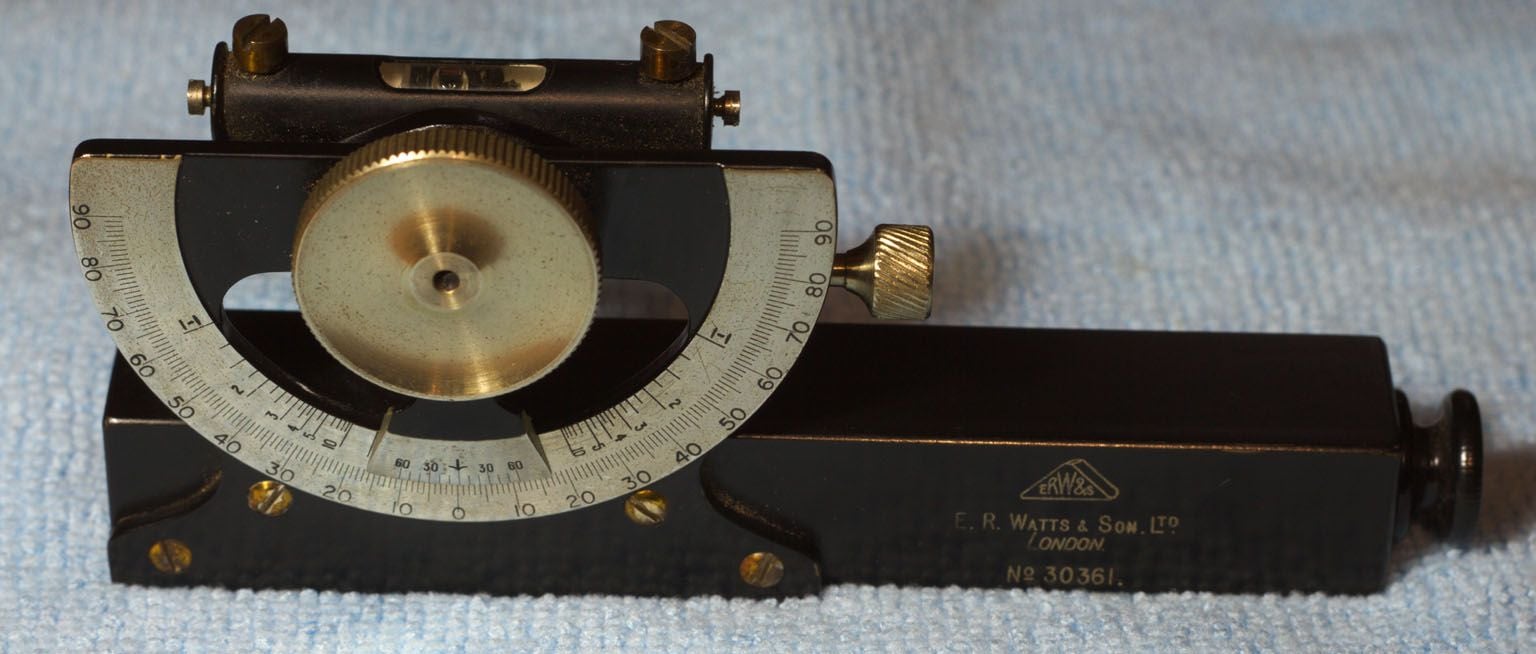
This is the original instrument for measuring slope, with a bit of practice I could probably use it.
I even found a PDF copy of "The Abney Level Handbook" 1935 - United States Depatrment of Agriculture / Forestry Service.
2) Cycling App
Apparently some cycling apps will use barometric pressure or GPS height to calculate the slope.
That's going to be fairly inaccurate over short distances.
3) Clinometer
There are handlebar clinometers around, here's the Sun Company CyclClimb
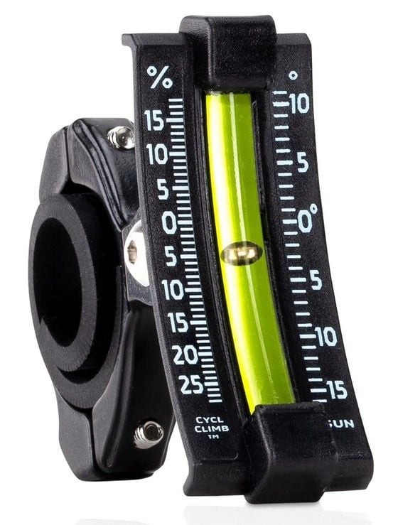
That's the only one I could find and it's �26 on Amazon. Looks ok for general levels but not particularly accurate.
4) Clinometer Phone App
There are several phone apps for measuring angles.
My theory is that my top tube it levelish so I could just meaure the angle of that to get the slope of the hill.
Here's the (free) app I used: https://play.google.com/store/apps/d...er&hl=en&gl=US
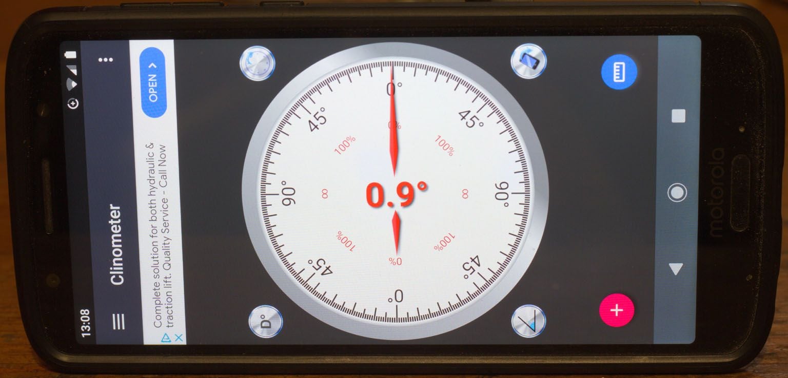
This was the right price for me, so here's my method.
I think it should cancel out any calibration error in the app.
a) Calibrate Top Tube
Put bicycle on a flattish surface and measure slope of top tube.
Reverse bicycle - wheels in same floor position but swapped front to back.
Measure slope of top tube again with the phone pointing in the same direction relative to the floor.
Difference in measurements is twice the top tube slope.
b) Measure slope
Stop bicycle on the slope
Measure angle with phone pointing up the hill
Walk round to other side of the bicycle.
Measure angle with phone pointing down the hill
Average of the measurements is the correct reading.
My hill:
If anybody can see an error in my logic please point it out
I use a small local slope to check the gears are working properly and to check for strange noises whenever I go out on a ride.
It's on a quiet straight backstreet with a 300 yard slope at the west end (Chartfield Avenue, London SW15).
But the slope to me looks to be around 5-7% and Komoot and other apps says it's 4%.
On the Avanti I go up it on 42/24 or 42/28.
So it occured to me it should be possible to measure the slope directly, I came up with 4 ways of doing it:
.
1) Abney Level
My dad was a paleontologist so I inherited a Surveyor's Abney Level:
This is the original instrument for measuring slope, with a bit of practice I could probably use it.
I even found a PDF copy of "The Abney Level Handbook" 1935 - United States Depatrment of Agriculture / Forestry Service.
2) Cycling App
Apparently some cycling apps will use barometric pressure or GPS height to calculate the slope.
That's going to be fairly inaccurate over short distances.
3) Clinometer
There are handlebar clinometers around, here's the Sun Company CyclClimb
That's the only one I could find and it's �26 on Amazon. Looks ok for general levels but not particularly accurate.
4) Clinometer Phone App
There are several phone apps for measuring angles.
My theory is that my top tube it levelish so I could just meaure the angle of that to get the slope of the hill.
Here's the (free) app I used: https://play.google.com/store/apps/d...er&hl=en&gl=US
This was the right price for me, so here's my method.
I think it should cancel out any calibration error in the app.
a) Calibrate Top Tube
Put bicycle on a flattish surface and measure slope of top tube.
Reverse bicycle - wheels in same floor position but swapped front to back.
Measure slope of top tube again with the phone pointing in the same direction relative to the floor.
Difference in measurements is twice the top tube slope.
b) Measure slope
Stop bicycle on the slope
Measure angle with phone pointing up the hill
Walk round to other side of the bicycle.
Measure angle with phone pointing down the hill
Average of the measurements is the correct reading.
My hill:
Cyclone slopes 0.375 degrees down (back to front)
Hill measurements: 3.6 degrees, 4.3 degrees, so average is 3.95 degrees
True angle 3.95 + 0.375 = 4.325 degrees
4.325 degrees = 7.56%
.Hill measurements: 3.6 degrees, 4.3 degrees, so average is 3.95 degrees
True angle 3.95 + 0.375 = 4.325 degrees
4.325 degrees = 7.56%
If anybody can see an error in my logic please point it out
Last edited by Aardwolf; 11-18-23 at 08:30 AM. Reason: typo
 11-18-23, 08:55 AM
#2

Happy With My Bikes

Join Date: Sep 2020
Location: Oklahoma
Posts: 2,187
Bikes: Hi-Ten bike boomers, a Trek Domane and some projects
Mentioned: 2 Post(s)
Tagged: 0 Thread(s)
Quoted: 884 Post(s)
Liked 2,308 Times
in
1,118 Posts
I'm not criticizing you by suggesting that you are overthinking this, because I overthink a lot of things too. I'd think the phone app would be a good enough option. With your phone fixed to the top tube or some other way to ensure it is level at the bottom of the hill, I would walk the bike up and check the angle every so many feet and average it out. Comparing your findings to those reported by Strava or other apps would give you an idea if there is some agreement between the methods.
__________________
"It is the unknown around the corner that turns my wheels." -- Heinz St�cke
"It is the unknown around the corner that turns my wheels." -- Heinz St�cke
11-18-23, 09:16 AM
#3
Senior Member

Join Date: Aug 2016
Location: Visalia, CA
Posts: 2,249
Mentioned: 45 Post(s)
Tagged: 0 Thread(s)
Quoted: 981 Post(s)
Liked 1,844 Times
in
609 Posts
If you're using the Strava app to track your rides it'll let you know with some detail about the hills you've climbed via elevation gain, slope, and distance, and will also conveniently combine those to provide insights into the "rigor" of the climb using the same formula that describes the climb categories seen in professional cycling.
-Gregory
-Gregory
Likes For Kilroy1988:
11-18-23, 09:26 AM
#4
Wheelman
Thread Starter
Join Date: Aug 2021
Location: Putney, London UK
Posts: 845
Bikes: 1982 Holdsworth Avanti (531), 1961 Holdsworth Cyclone
Mentioned: 4 Post(s)
Tagged: 0 Thread(s)
Quoted: 298 Post(s)
Liked 676 Times
in
341 Posts
If you're using the Strava app to track your rides it'll let you know with some detail about the hills you've climbed via elevation gain, slope, and distance, and will also conveniently combine those to provide insights into the "rigor" of the climb using the same formula that describes the climb categories seen in professional cycling.
-Gregory
-Gregory
I could be wrong - I have got (free) Strava so I should give it a try probably.
11-18-23, 09:31 AM
#5
Senior Member
Join Date: Aug 2016
Location: Visalia, CA
Posts: 2,249
Mentioned: 45 Post(s)
Tagged: 0 Thread(s)
Quoted: 981 Post(s)
Liked 1,844 Times
in
609 Posts
-Gregory
11-18-23, 09:43 AM
#6
Senior Member

Join Date: May 2012
Location: Point Reyes Station, California
Posts: 4,528
Bikes: Indeed!
Mentioned: 92 Post(s)
Tagged: 0 Thread(s)
Quoted: 1507 Post(s)
Liked 3,478 Times
in
1,132 Posts
Slope is generally measured in percent rather than degrees for roads and trails. We use the Suunto sighting clinometer in trail building.
Brent
Brent
__________________
"I have a tendency to meander sometimes." B.G.
"I have a tendency to meander sometimes." B.G.
11-18-23, 09:48 AM
#7
Wheelman
Thread Starter
Join Date: Aug 2021
Location: Putney, London UK
Posts: 845
Bikes: 1982 Holdsworth Avanti (531), 1961 Holdsworth Cyclone
Mentioned: 4 Post(s)
Tagged: 0 Thread(s)
Quoted: 298 Post(s)
Liked 676 Times
in
341 Posts
Slope is generally measured in percent rather than degrees for roads and trails. We use the Suunto sighting clinometer in trail building.
Brent
Brent
But to calculate averages etc you need to use degrees.
11-18-23, 10:00 AM
#8
Senior Member

Join Date: Jan 2015
Location: Los Angeles
Posts: 4,707
Bikes: 82 Medici, 2011 Richard Sachs, 2011 Milwaukee Road
Mentioned: 55 Post(s)
Tagged: 0 Thread(s)
Quoted: 1952 Post(s)
Liked 2,013 Times
in
1,112 Posts
I’m looking forward to the results using the Abney. My mom and dad sold my grandpa’s surveying equipment at a garage sale without asking me☹️
__________________
I don't do: disks, tubeless, e-shifting, or bead head nymphs.
I don't do: disks, tubeless, e-shifting, or bead head nymphs.
11-18-23, 10:09 AM
#9
Wheelman
Thread Starter
Join Date: Aug 2021
Location: Putney, London UK
Posts: 845
Bikes: 1982 Holdsworth Avanti (531), 1961 Holdsworth Cyclone
Mentioned: 4 Post(s)
Tagged: 0 Thread(s)
Quoted: 298 Post(s)
Liked 676 Times
in
341 Posts
Here's the Abney handbook: https://upload.wikimedia.org/wikiped...935calk%29.pdf
I'm currently checking that all the bits move that are supposed to - hasn't been used in 40 years or more.
I'm currently checking that all the bits move that are supposed to - hasn't been used in 40 years or more.
11-18-23, 01:17 PM
#10
Senior Member

Join Date: Feb 2008
Location: Peoria, IL
Posts: 4,476
Mentioned: 86 Post(s)
Tagged: 0 Thread(s)
Quoted: 1829 Post(s)
Liked 3,376 Times
in
1,580 Posts
I don't see any issues with the techniques proposed.
Naturally, they all have their own advantages and issues.
I have used the Sky Mounti, which is a curved bubble level type of device. It was handy for getting a general idea of the slope of the road while riding. Like anything that relies the relative gravity vector, any sort changes in your speed will affect the indicated slope. For best accuracy, you'll want to stop and get a measurement.
I've got a spare Sky Mounti, in case anyone is interested in trying one out at a low price.
The phone-based inclinometers do fairly well, based on some quick experiments that I've done. Certainly good enough for most of us.
In most cases, I don't tend to worry about the slope of the hills I'm riding on. It can be handy to know the slope of some roads, if only to know how steep they really are and what gearing is suitable. It's also helpful when describing a hill to a friend, when they want to know how one hill compares to another. If, for instance, they know that they can climb up Mossville road, but aren't familiar with Cedar Hills drive, I can tell them that both are steady 14% grades and should be equally difficult.
Cedar Hills Dr. has a better shoulder, though, so I'd recommend that as the best way to get out of the river valley.
Steve in Peoria, where our steepest hills are actually valleys.
Likes For steelbikeguy:
11-18-23, 01:42 PM
#11
Bike Butcher of Portland

Join Date: Jul 2014
Location: Portland, OR
Posts: 11,639
Bikes: It's complicated.
Mentioned: 1299 Post(s)
Tagged: 0 Thread(s)
Quoted: 4682 Post(s)
Liked 5,802 Times
in
2,286 Posts
I try to stay away from actual measurement of hills. Many times I've gotten to the top of one, catching up with the climbers waiting for me, and proclaimed, "Man, that musta been 8%!" Someone with a GPS device will correct me, "No Gugie, that was only 5%"
As I like to say, don't let the truth get in the way of a good story.
As I like to say, don't let the truth get in the way of a good story.
__________________
If someone tells you that you have enough bicycles and you don't need any more, stop talking to them. You don't need that kind of negativity in your life.
If someone tells you that you have enough bicycles and you don't need any more, stop talking to them. You don't need that kind of negativity in your life.
Likes For gugie:
11-18-23, 02:14 PM
#12
Wheelman
Thread Starter
Join Date: Aug 2021
Location: Putney, London UK
Posts: 845
Bikes: 1982 Holdsworth Avanti (531), 1961 Holdsworth Cyclone
Mentioned: 4 Post(s)
Tagged: 0 Thread(s)
Quoted: 298 Post(s)
Liked 676 Times
in
341 Posts
I don't take it too seriously
I'm mainly interested in measuring my test hill so I can get some idea of what hills I should be ok on using my new lower gear - 36/32.
But the best way to check that is probably to try some hills.
It also helps calibrate my built in hill estimation, Komoot saying the hill was 4% was making me doubt my senses.
11-18-23, 03:09 PM
#13
Senior Member
Join Date: Feb 2008
Location: Peoria, IL
Posts: 4,476
Mentioned: 86 Post(s)
Tagged: 0 Thread(s)
Quoted: 1829 Post(s)
Liked 3,376 Times
in
1,580 Posts
I will usually map routes with RideWithGPS, and it provides an indication of the grade along the route. However, the grade data is a bit coarse and it's hard to know exactly what data points were used to generate that value for grade. The goal is to know how much to trust its numbers when I'm planning new rides.
I've had rides where I put the Sky Mounti on the bike and stopped to take a quick photo of it for later
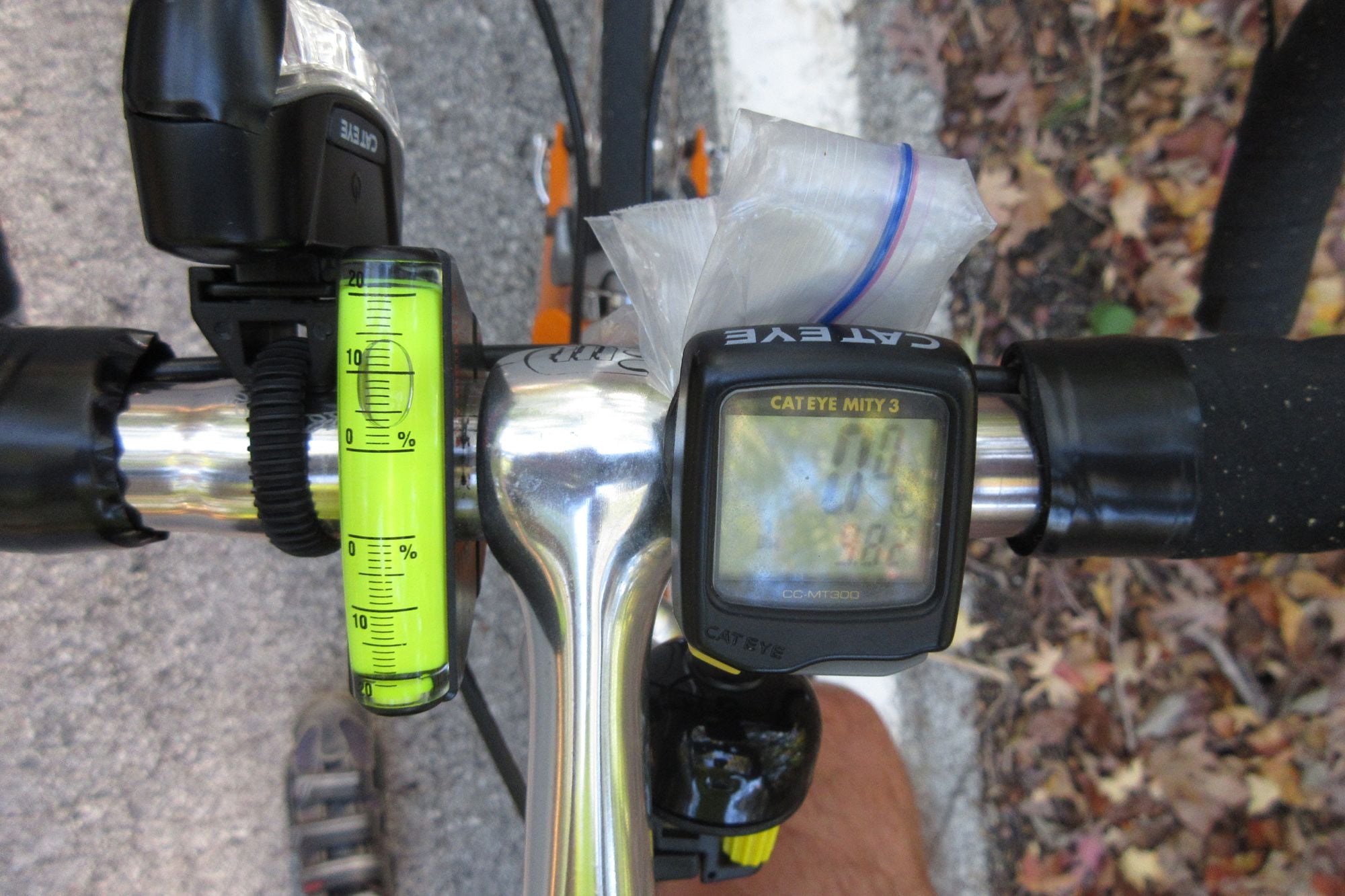
It's important to get the mileage in the shot too, just to help correlate it with the graph of elevation from RideWithGPS...
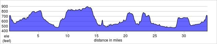
The elevation sure looks steep at 9.8 miles, but I'd have to go to the RideWithGPS site to put the cursor on the route and get the grade info for a particular point. Too bad they don't provide a graph for grade too.
Steve in Peoria
11-18-23, 03:23 PM
#14

Senior Member
Join Date: Dec 2005
Posts: 17,159
Mentioned: 481 Post(s)
Tagged: 0 Thread(s)
Quoted: 3811 Post(s)
Liked 6,710 Times
in
2,613 Posts
I use a Wahoo GPS device and import routes from Ride with GPS. A newish feature seems to be a hill tracker of sorts: When I come up to a climb, my device announces the hill, gives me some stats on length and average grade and then announces, “CLIMB!” I’ve found myself switching to a different screen on most rides as I’d really rather not know that a steep climb will get even steeper or how much further I have to climb. I prefer to put my head down and grind it out.
11-18-23, 03:30 PM
#15
Senior Member
The app I used back in the day was mapmyride, it did an adequate job and adequate was good enough. It would fall apart on some back country roads with tunnels, where the incline measurement was being taken from the topology rather than the road data. I would be like a mole taking a shortcut through the mountain while the app said I was on a 45% incline.
11-18-23, 05:28 PM
#16

don't try this at home.

Join Date: Jan 2006
Location: N. KY
Posts: 5,940
Mentioned: 10 Post(s)
Tagged: 0 Thread(s)
Quoted: 974 Post(s)
Liked 512 Times
in
352 Posts
Actual grade calc via a phone app
I use my Garmin grade percentage as a reasonable grade indication. It averages over a 6 second interval, and isn't good at high accuracy on very short, steep pitches.
My Samsung phone has the android Bubble Level app on it. It's well designed, showing a bubble level along with a digital readout with the phone flat on the table, or a carpenter's level + readout if stood vertically on the bottom or side edge of the phone.
I have a very good 4 foot carpenter's level, and this app is within 1/10 percent of "0%" with the 4 foot level centered. It can display in degrees or slope percentage. It can be zeroed to any angle too.
My top tube slants front-to-back. With the bike on a known flat floor, with the phone base on the top tube and the phone edge against my stem, the bubble level shows "14.3 percent" slope toward the saddle.
I made a note of this for future reference. I can tilt the phone app to read "14.3" then press the Zero set button. Now, stopping on a hill, with the phone on the top tube as mentioned above, it reads the grade percentage directly.
I was interested in one of the notorious steeper hills in the area, and stopped during a downhill ride on that hill. Yes, it's steep: 22%. (It's very hard to completely stop on a 22% grade, and bike shoes aren't designed for this either!)
Last edited by rm -rf; 03-20-24 at 09:23 AM.
Likes For rm -rf:
11-18-23, 05:37 PM
#17
don't try this at home.
Join Date: Jan 2006
Location: N. KY
Posts: 5,940
Mentioned: 10 Post(s)
Tagged: 0 Thread(s)
Quoted: 974 Post(s)
Liked 512 Times
in
352 Posts
I find that to be valuable too.
I will usually map routes with RideWithGPS, and it provides an indication of the grade along the route. However, the grade data is a bit coarse and it's hard to know exactly what data points were used to generate that value for grade. The goal is to know how much to trust its numbers when I'm planning new rides.
I've had rides where I put the Sky Mounti on the bike and stopped to take a quick photo of it for later
It's important to get the mileage in the shot too, just to help correlate it with the graph of elevation from RideWithGPS...
The elevation sure looks steep at 9.8 miles, but I'd have to go to the RideWithGPS site to put the cursor on the route and get the grade info for a particular point. Too bad they don't provide a graph for grade too.
Steve in Peoria
rwgps can be incorrect on hills. Locally, it's data shows a steep dip at a creek crossing -- but there's been a bridge there for 50 or more years. Some roads were straightened and the hill cut into, to make a consistent, modern highway road. The map still shows the old hill grade that's been cut through.
There's always a low chance of a "5-6%" climb being "10-12%" for a somewhat short distance. That's fairly rare, though.
And tunnels are often wrong. Even the Blue Ridge Parkway tunnels show a very steep climb over the ridge instead of the tunnel!
Likes For rm -rf:
11-19-23, 12:19 AM
#18
Crawlin' up, flyin' down

Join Date: Jan 2006
Location: Democratic Peoples' Republic of Berkeley
Posts: 5,658
Bikes: 1967 Paramount; 1982-ish Ron Cooper; 1978 Eisentraut "A"; two mid-1960s Cinelli Speciale Corsas; and others in various stages of non-rideability.
Mentioned: 40 Post(s)
Tagged: 0 Thread(s)
Quoted: 1027 Post(s)
Liked 2,531 Times
in
1,059 Posts
Before altimeters/grade calculators were common in bike computers, I used a variation of the bubble level device. I called it my Pain-O-Meter(TM).
I also use the gugie method outlined above, although I generally come in behind him, supplemented by how close I feel to barfing up a lung. When it comes to climbing, my main function in a group is to make everyone else fell good about themselves.
I also use the gugie method outlined above, although I generally come in behind him, supplemented by how close I feel to barfing up a lung. When it comes to climbing, my main function in a group is to make everyone else fell good about themselves.
__________________
"I'm in shape -- round is a shape." Andy Rooney
"I'm in shape -- round is a shape." Andy Rooney
11-19-23, 02:55 AM
#19
Strong Walker

Has any of those airbubble inclinometers ever worked?
I remember Ciclomaster had a very expensive altitude addon for their model II that tried its luck with a liquid damped pendulum. Was about as precise as a crystal ball.
What about this: measure distance from bottom to top - measure or read elevation. Elevation gain/distance ridden = slope steepness.
Likes For martl:
11-19-23, 06:09 AM
#20
Senior Member
Join Date: Aug 2007
Location: Evanston, IL
Posts: 5,095
Bikes: many
Mentioned: 63 Post(s)
Tagged: 0 Thread(s)
Quoted: 1445 Post(s)
Liked 1,395 Times
in
762 Posts

I use the Clinometer app from time-to-time, but haven't tried it for this application. If I'm curious, I just go with whatever my Wahoo Bolt says.
Apologies for the diversion. Back to your regularly scheduled programming.
Last edited by smontanaro; 11-19-23 at 06:16 AM.
11-19-23, 07:17 AM
#21
Full Member

Join Date: Jul 2023
Location: "Driftless" WI
Posts: 387
Bikes: 1972 Motobecane Grand Record, 2022 Kona Dew+
Mentioned: 2 Post(s)
Tagged: 0 Thread(s)
Quoted: 157 Post(s)
Liked 146 Times
in
107 Posts
S'what I Use...
If you're using the Strava app to track your rides it'll let you know with some detail about the hills you've climbed via elevation gain, slope, and distance, and will also conveniently combine those to provide insights into the "rigor" of the climb using the same formula that describes the climb categories seen in professional cycling.
(I do have a little WIXEY thingy that gives degrees of pitch readout to 0.1�, use to ensure my table saw's set up for truly square cuts:
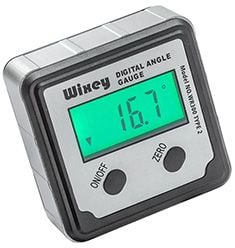
Has a magnetic base so I could stick it to my MB's top tube, but as it's screen'd be facing away from my face I'd have to connive some means of viewing or otherwise recording its display... maybe a GoPro? Sheesh....)
Strava's useful for other pursuits like swimming, XC skiing, even rowing (boat vs. machine) and sailing, when I can make that happen.
Last edited by spclark; 11-19-23 at 07:29 AM.
11-19-23, 09:25 AM
#22
Senior Member
Join Date: Nov 2005
Location: NW Ohio
Posts: 3,421
Bikes: 1984 Miyata 310, 1986 Schwinn Sierra, 2011 Jamis Quest, 1980 Peugeot TH8 Tandem, 1992 Performance Parabola, 1987 Ross Mt. Hood, 1988 Schwinn LeTour, 1988 Trek 400T, 1981 Fuji S12-S LTD, 197? FW Evans
Mentioned: 24 Post(s)
Tagged: 0 Thread(s)
Quoted: 532 Post(s)
Liked 1,007 Times
in
516 Posts
Where I live, the rigor of just about all climbs would be "not actually a hill."
I use the Clinometer app from time-to-time, but haven't tried it for this application. If I'm curious, I just go with whatever my Wahoo Bolt says.
Apologies for the diversion. Back to your regularly scheduled programming.
I use the Clinometer app from time-to-time, but haven't tried it for this application. If I'm curious, I just go with whatever my Wahoo Bolt says.
Apologies for the diversion. Back to your regularly scheduled programming.
") 11-19-23, 09:44 AM
11-19-23, 09:44 AM
#23
Senior Member
Join Date: Jan 2016
Posts: 3,449
Mentioned: 33 Post(s)
Tagged: 0 Thread(s)
Quoted: 874 Post(s)
Liked 2,290 Times
in
1,279 Posts
In my technical, over thinking method of measurement , I have boiled hills down to two groups . Those that I can climb by pedaling and those that I walk up. The numbers no longer matter to me , my legs know what to do. I live on a steep hill so I always use both methods of climbing!
11-19-23, 07:48 PM
#24
Crawlin' up, flyin' down
Join Date: Jan 2006
Location: Democratic Peoples' Republic of Berkeley
Posts: 5,658
Bikes: 1967 Paramount; 1982-ish Ron Cooper; 1978 Eisentraut "A"; two mid-1960s Cinelli Speciale Corsas; and others in various stages of non-rideability.
Mentioned: 40 Post(s)
Tagged: 0 Thread(s)
Quoted: 1027 Post(s)
Liked 2,531 Times
in
1,059 Posts
Not very well. Getting the set up so the angle from which you are looking at the device is critical and kind of annoying. Not hard, but annoying. Once you've done that, you discover that any surging or slacking in your pace also affects the bubble. So if you are going a constant x degree slope, stepping on the gas a little or standing up to stomp for a bit will make the bubble say you are riding a >x degree slope. And that doesn't even account for the slightly different angle of viewing the device which changes what you see as the reading. All in all, I found it could, at best, give a fairly reasonable approximation of the order of magnitude of the slope, and was slightly better at comparisons (this slope on X Road is less than/greater than/about the same as the slope on Y Road), Mildly interesting as a conversation piece with other cyclists, but overall more trouble than the info provided was worth.
__________________
"I'm in shape -- round is a shape." Andy Rooney
"I'm in shape -- round is a shape." Andy Rooney
11-19-23, 09:29 PM
#25
Wheelman
Thread Starter
Join Date: Aug 2021
Location: Putney, London UK
Posts: 845
Bikes: 1982 Holdsworth Avanti (531), 1961 Holdsworth Cyclone
Mentioned: 4 Post(s)
Tagged: 0 Thread(s)
Quoted: 298 Post(s)
Liked 676 Times
in
341 Posts
FYI
That one I mentioned uses a brass ball instead of an air bubble, so I think the ball falls to the lowest point (by gravity) in the tube. Maybe that's more damped.
https://www.amazon.co.uk/Sun-Company...s%2C123&sr=8-3
But it's still not worth �26 unless you have a particular need for a continuous slope measurement.
